Posted by AGORACOM
at 8:54 AM on Thursday, October 29th, 2020
VANCOUVER, British Columbia, Oct. 29, 2020 (GLOBE NEWSWIRE) — Candente Gold Corp. (TSXV:CDG) (“Candente Gold” and/or the “Company”) is pleased to announce that high grade gold and silver has been sampled on the Cocula project.
As reported in News Release dated, October 22nd, 2020, samples collected to check historical reporting confirmed grades of 5.663 grams per tonne (“g/t”) gold over 6 metres and 4.322 g/t gold over 8 metres in quartz breccia bodies which we understand are typical throughout the deposit.
In addition, higher grades of 59.0 g/t gold and 729 g/t silver have been found in a selected sample over 10 centimetres (“cm”) in the hanging wall of a quartz vein-breccia structure near the portal of a collapsed adit. We understand mineralization was previously exploited from this adit on a small scale using a flotation recovery process but the Company has not found any formal production records. The mineralization in the high grade sample is described as dark grey to milky white banded quartz in vein and breccia with galena, pyrite and quartz crystals filling open spaces. A channel sample collected over 0.75 m adjacent to the selected sample and including part of the hanging wall, only returned 0.182 g/t gold and 18.9 g/t silver. The channel sample comprised milky white and gray to dark gray quartz breccia vein with fine grained pyrite, +1% galena and trace malachite. The Company understands that the high grades are coming from a bonanza zone for which we have no idea of the size or extent yet. Due to the nature of the high grades, the bonanza zone samples were check assayed in a second laboratory. The two laboratories used are the Alti Plano Gold Silver laboratory in Matehualas, San Luis Potosi, Mexico owned by Reyna Mining and Inspectorate Laboratory owned by Bureau Veritas who prepare their samples in Durango, Mexico and conduct sample analyses in Vancouver, Canada.
Base metal assays and multi-element ICP analyses are still pending for the rock check samples as are results from preliminary metallurgical testing.
The due diligence work is being conducted by Ing. Humberto Hernandez, Geological Engineer, member of Asociación de Ingenieros Mineros, Metalúrgistas y Geólogos de México and Ing. Gerardo Moreno, Geological Engineer and Miner, of Grupo Constructor Germo based in Durango, Mexico.
The Cocula Project area is located within the Ameca Mining District of Jalisco State which is home to Agnico Eagle’s El Barqueño Project and Endeavor Silver’s Terronera Project.
Please see News Releases No. 084 and 086 dated September 10th, and October 22nd, 2020 and http://www.candentegold.com/s/cocula.asp for further details on the Cocula Project.
About Candente Gold
Candente Gold has launched a comprehensive growth strategy to build a cash flowing business platform and gain access to properties with near surface exploration potential while maintaining El Oro as its flagship asset and an integral part of the overall growth strategy. The acquisition of the SDA Plant, the El Dorado historic mines and the Cocula Project signifies an important first step.
The financial benefits from Western Mexico operations and the addition of specialized personnel will translate across platforms to strengthen our efforts to explore and potentially mine. The Company is currently evaluating other properties that are complimentary to the SDA plant, El Dorado and the Cocula Project.
El Oro is a district scale gold project encompassing a well-known prolific high-grade gold dominant gold-silver epithermal vein system in Mexico. The project covers 20 veins with past production and more than 57 veins in total, from which approximately 6.4 million ounces of gold and 74 million ounces of silver were reported to have been produced from just two of these veins (Ref. Mexico Geological Service Bulletin No. 37, Mining of the El Oro and Tlapujahua Districts. 1920, T. Flores*)
Modern understanding of epithermal vein systems indicates that several of the El Oro district’s veins hold excellent discovery potential, particularly below and adjacent to the historic workings of the San Rafael Vein, which was mined to an average depth of only 200 metres.
Joanne C. Freeze, P.Geo., President, CEO and Director and Matthew Melnyk, CPG., Director Operations and Director are Qualified Persons as defined by National Instrument 43-101 for the projects discussed above, however they have not been able to visit the Cocula Project recently due to COVID virus travel restrictions. The work discussed in the News Release is either historical and documented by public records or conducted by Mexican professionals with qualifications similar to those of QP’s registered in Canada. Ms. Freeze and Mr. Melnyk have reviewed and approved the contents of this release.
Neither TSX Venture Exchange nor its Regulation Services Provider accepts responsibility for the adequacy or accuracy of this release.
Forward-looking Information
This news release may contain forward-looking information (as such term is defined under Canadian securities laws) including but not limited to information regarding the potential for and other statements that are not historical facts. While such forward-looking information is expressed by Candente Gold in good faith and believed by Candente Gold to have a reasonable basis, they address future events and conditions and are therefore subject to inherent risks and uncertainties including those set out in Candente Gold’s MD&A. Factors that cause the actual results to differmaterially from those in forward-looking information include, without limitation, gold prices, results of exploration and development activities, regulatory changes, defects in title, availability of materials and equipment, timeliness of government approvals, potential environmental issues, availability of capital and financing and general economic, market or business conditions. Candente Gold expressly disclaims any intention orobligation to update or revise any forward-looking information, whether as a result of new information, future events or otherwise, except in accordance with applicable securities laws.
On behalf of the Board of Candente Gold Corp. “Joanne Freeze” P.Geo. President, CEO and Director
For further information please contact: Joanne Freeze President & CEO Tel: + 1 (604) 689-1957
Posted by AGORACOM
at 9:13 AM on Monday, October 26th, 2020
American Creek’s JV Partner Tudor Gold Intersects 1,152 Meters of 0.741 gpt AuEq, Including 1.561 gpt AuEq over 121.5 Meters and 0.968 gpt AuEq over 414 Meters with Hole GS-20-75
Step-Out Hole GS-20-70 Extends the Goldstorm 300 Horizon and CS-600 Zone Another 150 Meters to the Northeast as Drilling Continues with Six Drills at Treaty Creek
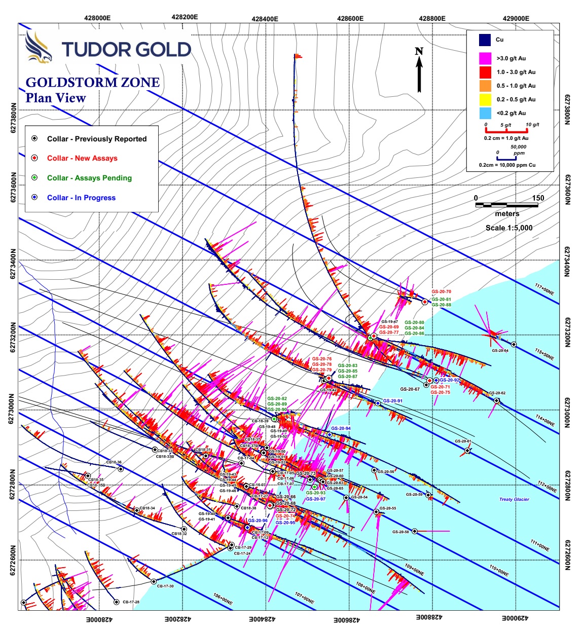
Cardston, Alberta–(Newsfile Corp. – October 26, 2020) – American Creek Resources Ltd. (TSXV: AMK) (“the Corporation”) is pleased to present results for the fourth set of diamond drill holes at their flagship property, Treaty Creek, located in the heart of the Golden Triangle of Northwestern British Columbia. Diamond drilling continues with six drill rigs currently working on the Goldstorm Zone which is on-trend from Seabridge’s KSM Project, 5 km to the southwest. All nine of the recent drill holes have successfully intersected the Goldstorm System expanding the mineralization to the northeast and southeast, as well as to depth. The Goldstorm System 300 Horizon has now been traced for 1100 meters along the northeast axis and in addition, the CS-600 and DS-5 systems have been expanded to the northeast and to depth as well. All 26 drill holes completed at Goldstorm during the 2020 program have encountered significant precious metal mineralization.
Tudor Gold’s Vice President of Project Development, Ken Konkin, P.Geo., stated: “The goal is to drill-define the limits of the Goldstorm system mineralization. We are very pleased with the results obtained from the 2020 drill holes that have yet to define limits or boundaries to the mineralized target along the northeastern and the southeastern axes, and to depth as well as we keep encountering mineralization versus non-mineralized host rock. Drill hole results from GS-20-75 demonstrate that several aspects of the mineralized horizon appear to be gaining strength at depth with significant Au-Cu-Ag mineralization encountered in the CS-600 zone which averaged 0.968 gpt AuEq over 414 meters. Our technical team has to date received drill hole results from 26 diamond drill holes at Goldstorm and three holes from the PSZ Zone, totaling 24,343.6 meters. Samples from 12 drill holes are awaiting results from MSA Labs, totaling 12,443.7 meters, with six additional holes currently being drilled that are expected to total more than 6,500 meters. The information released to date represents just over half of the drill information we plan to collect for this year’s program at Goldstorm. We have also received good news from MSA Labs that they hope to get back to our scheduled 15-day turn-around-time for results. We are confident that our combined efforts will expediate the news flow for the near-future.”
Goldstorm Highlights include:
Nine diamond drill holes in this release totaled 10,234.2 meters, all hitting the intended targets with favorable results listed in the tables below.
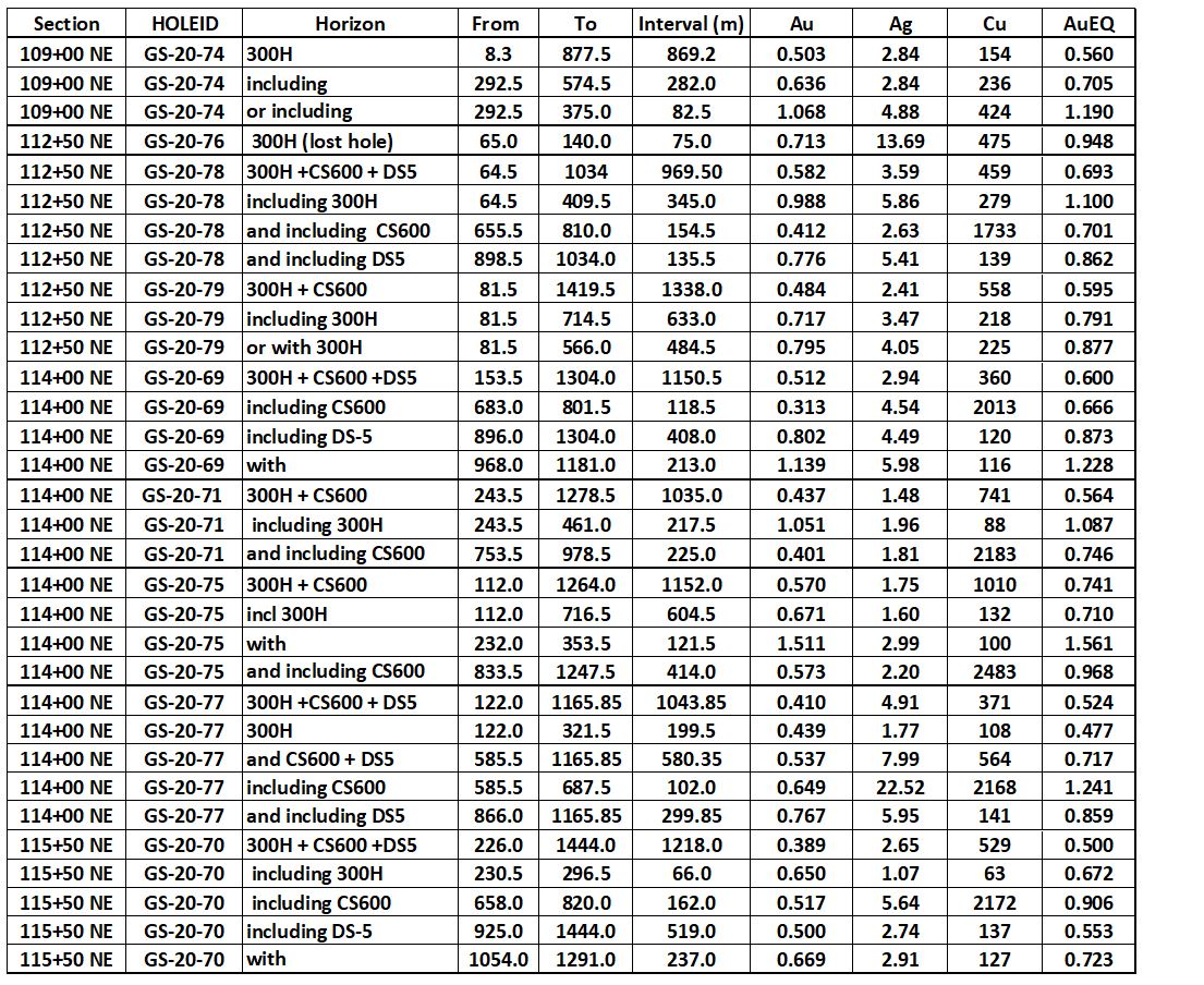
Best intercept was from GS-20-75 on Section 114+00 NE that averaged 0.741 gpt AuEq over 1152.0 metres (112.0-1264.0 m) containing an enriched portion of 121.5 meters (232.0-353.5 m) that averaged 1.561 gpt AuEq.
GS-20-75 also had a remarkable 414.0 meter intercept (833.5-1247.5 m) of 0.968 gpt AuEq within the CS-600 Zone, which is the longest intercept for CS-600 drilled to date.
Tudor Gold has surpassed the previous longest mineralized intercept with GS-20-79 on section 112+00 NE, 150 meters southwest of GS-20-75. This hole intersected 1338 meters (81.5-1419.5m) of 0.595 gpt Au Eq with the upper portion of the 300 Horizon averaging 0.877 gpt AuEq over 484.5 meters (81.5-566.0 m).
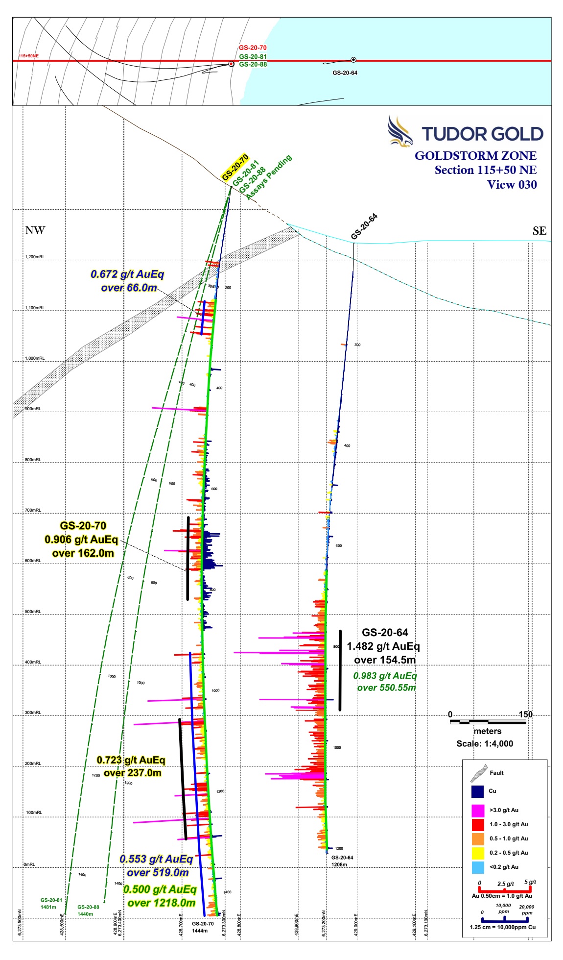
A 150 meter extension of the 300, CS-600 and DS-5 Zones was confirmed by an aggressive step-out to the northeast with hole GS-20-70 on section 115+50 NE. The intercept averaged 0.500 gpt AuEq over 1218.0 meters and mineralization remains open to the northeast, northwest and southeast along Section 115+50 NE.
The DS-5 System appears to be gaining strength to the northeast; hole GS-20-64, the north-easternmost hole, returned the strongest result for DS-5, averaging 0.983 gpt AuEq over 550.55 meters with an enriched portion averaging 1.482 gpt AuEq over 154.5 meters (Press Release July 27, 2020).
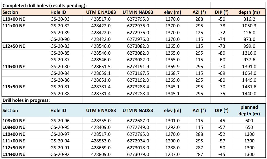
The following three tables below provide the complete list of composited drill hole results as well as the drill hole data including hole location, elevation, depth, dip and azimuth.
All assay values are uncut and intervals reflect drilled intercept lengths.
HQ and NQ2 diameter core samples were sawn in half and typically sampled at standard 1.5m intervals.
The following metal prices were used to calculate the Au Eq metal content: Gold $1322/oz, Ag: $15.91/oz, Cu: $2.86/lb. Calculations used the formula Au Eq g/t = (Au g/t) + (Ag g/t x 0.012) + (Cu% x 1.4835). All metals are reported in USD and calculations do not consider metal recoveries. True widths have not been determined as the mineralized body remains open in all directions. Further drilling is required to determine the mineralized body orientation and true widths.
Table lll: Drill Data for Holes Completed, Pending Results and Currently Drilling
Attached are Sections 109+00 NE, 112+50 NE, 114+00 NE and 115+50 NE showing holes traces with gold and copper histogram results and a Plan Map showing the drill hole and section locations.
Walter Storm, President and CEO, stated: “For the fourth consecutive press release this year, we again are very pleased to announce a result that surpassed our finest result from the 2019 drill program. Last year, we had an excellent intercept from hole GS-19-47, which yielded 0.697 gpt Au Eq over 1081.5 meters (Section 114+00 NE)- and now we have yet another hole, GS-20-75 with a comparable result that was drilled along the same section but in the opposite direction from GS-19-47. Drill hole GS-20-75 averaged 0.741 gpt Au Eq over an impressive 1152.0 meters. With every hole our technical team completes, we are further defining the mineralized area. Clearly, however, much more drilling is required to locate the limits of the system due to the size and robust nature of the mineralization. Our commitment is to advance the project as far as possible this year and our team will push the winter elements to continue drilling as long as the conditions permit. We are proud of what we have achieved in these last two years of exploration. Given the amount of geological potential that the entire project possesses with the Goldstorm, Perfect Storm Z, Eureka and Orpiment Systems, we believe that similar results will continue to enhance the prospects for the Treaty Creek Project.”
Darren Blaney, CEO of American Creek commented: “The Goldstorm continues to impress. Yet another step out hole has hit significant gold mineralization and has extended the zone another 150m to the northeast. Even after all this 2020 drilling, we still don’t know the extent or bounds of the Goldstorm but clearly, it’s a truly massive gold zone. I congratulate Walter, Ken, and the whole Tudor team on the incredible effort and the associated incredible success as they continue to keep six drills turning at Treaty Creek. I also commend Sean and the More Core Drilling team for their commitment and Get it Done attitude and professionalism.”
Tudor Gold Corp and associated service companies have taken extreme measures to maintain the highest professional standards while working within COVID-19 health and safety protocols. Only essential personnel are permitted to enter the camp and staging areas. Of those who are at the project site and staging site, we have strict daily monitoring of the workers’ temperatures and general health conditions. We have a certified paramedic at the staging area to examine all in-coming and out-going Tudor personnel and all service providers.
The Treaty Creek Project is a Joint Venture with Tudor Gold owning 3/5th and acting as operator. American Creek and Teuton Resources each have a 1/5th interest in the project creating a 3:1 ownership relationship between Tudor Gold and American Creek. American Creek and Teuton are both fully carried until such time as a Production Notice is issued, at which time they are required to contribute their respective 20% share of development costs. Until such time, Tudor is required to fund all exploration and development costs while both American Creek and Teuton have “free rides”.
Treaty Creek Background
The Treaty Creek Project lies in the same hydrothermal system as Pretium’s Brucejack mine and Seabridge’s KSM deposits with far better logistics.
For a better understanding of the mineralized zones at the Goldstorm, please view this video (which shows the original 20,000m planned drill program opposed to the 40,000m+ drill program that has taken place).
American Creek is a Canadian junior mineral exploration company with a strong portfolio of gold and silver properties in British Columbia.
Three of those properties are located in the prolific “Golden Triangle”; the Treaty Creek JV with Tudor Gold/Walter Storm, the D-1 McBride, and the 100% owned past producing Dunwell Mine.
The Corporation also holds the Gold Hill, Austruck-Bonanza, Ample Goldmax, Silver Side, and Glitter King properties located in other prospective areas of the province.
See additional images of drill locations in this press release at www.americancreek.com.
For further information please contact Kelvin Burton at: Phone: 403 752-4040 or Email: [email protected]. Information relating to the Corporation is available on its website at www.americancreek.com.
Neither the TSX Venture Exchange nor its Regulation Services Provider (as that term is defined in the policies of the TSX Venture Exchange) accepts responsibility for the adequacy or accuracy of this release.
This news release contains forward-looking statements. These statements are based on current expectations and assumptions that are subject to risks and uncertainties. Readers should not place undue importance on forward-looking information and should not rely upon this information as of any other date. Actual results could differ materially because of factors discussed in the Corporation’s management discussion and analysis filed with applicable Canadian securities regulators, which can be found under the Corporation’s profile on www.sedar.com. The Corporation does not assume any obligation to update any forward-looking statements.
Posted by AGORACOM
at 8:59 AM on Thursday, October 22nd, 2020
Candente believes the Conceptual Exploration Targets have potential grading from 0.5 g/t Au to 2.75 g/t Au containing between 50,000 and 100,000 oz Au
VANCOUVER, British Columbia, Oct. 22, 2020 (GLOBE NEWSWIRE) — Candente Gold Corp. (TSXV:CDG) (“Candente Gold” and/or the “Company”) is pleased to announce that a due diligence site visit to the Cocula Gold Project in Jalisco, Mexico has been completed. Samples were collected to check historical reporting and also to conduct preliminary metallurgical test work to assist in determining the best methods for processing material from the deposit.
The most extensive work on the Cocula Project to date was conducted by Timmins Gold Corp. (“Timmins”) between 2007 and 2011. Timmins delineated disseminated gold, silver, lead, zinc and copper mineralization as well as higher grade zones of the same metals. The mineralization has been found, to date, near and at-surface, over an 800m length and 54 metre depth within a NW-SE trending fault zone.
Timmins work comprised comprehensive exploration which included geological mapping, geochemical sampling, trenching, Reverse Circulation (“RC”) drilling (1,974 meters (“m”)) and leach testing. Significant results from the RC drilling and trenching included 54m grading 4.97 grams per tonne (“g/t”) gold in a trench across the center of the mineralized area. An RC hole drilled beneath this trench encountered 37.5m grading 1.3 g/t gold including 7.5m grading 5.8 g/t from surface to a 7.5m depth.
The Company has reviewed the above as well all reports and data available and considers there is potential for conceptual exploration targets including a lower grade bulk tonnage, potentially leachable deposit as well as a higher grade/lower tonnage core of the deposit. Based on all of the existing exploration data and previous resource estimates to date the Company believes the Conceptual Exploration Targets have potential for: 500,000 to 6,000,000 tonnes grading from 0.5 g/t Au to 2.75 g/t Au containing between 50,000 and 100,000 oz Au with secondary credits from silver, lead, zinc and copper. The above is based on exploration to date by Timmins and other and does not include additional exploration potential. The potential quantity and grade described above is conceptual in nature, that there has been insufficient exploration to define a mineral resource and it is uncertain if further exploration will result in the target being delineated as a mineral resource.
Check sampling conducted by Ing. Humberto Hernandez, Geological Engineer, member of Asociación de Ingenieros Mineros, Metalúrgistas y Geólogos de México, has confirmed grades of 5.663 g/t gold over 6 metres and 4.322 g/t gold over 8 metres in quartz breccia bodies which also contain galena and sphalerite.
Samples have also been collected for preliminary metallurgical testing to assist the Company in identifying potential opportunities for a leaching and/or a flotation operation. Some of the extraction processes being considered could involve the use of the recently optioned SDA plant in Acaponeta. This work is being overseen by Ing. Gerardo Moreno, Geological Engineer and Miner, of Grupo Constructor Germo based in Durango, Mexico.
The Cocula Project area is located within the Ameca Mining District of Jalisco State which is home to Agnico Eagle’s El Barqueño Project and Endeavor Silver’s Terronera Project.
Candente Gold has launched a comprehensive growth strategy to build a cash flowing business platform and gain access to properties with near surface exploration potential while maintaining El Oro as its flagship asset and an integral part of the overall growth strategy. The acquisition of the SDA Plant, the El Dorado historic mines and the Cocula Project signifies an important first step.
The financial benefits from Western Mexico operations and the addition of specialized personnel will translate across platforms to strengthen our efforts to explore and potentially mine. The Company is currently evaluating other properties that are complimentary to the SDA plant, El Dorado and the Cocula Project.
El Oro is a district scale gold project encompassing a well-known prolific high-grade gold dominant gold-silver epithermal vein system in Mexico. The project covers 20 veins with past production and more than 57 veins in total, from which approximately 6.4 million ounces of gold and 74 million ounces of silver were reported to have been produced from just two of these veins (Ref. Mexico Geological Service Bulletin No. 37, Mining of the El Oro and Tlapujahua Districts. 1920, T. Flores*)
Modern understanding of epithermal vein systems indicates that several of the El Oro district’s veins hold excellent discovery potential, particularly below and adjacent to the historic workings of the San Rafael Vein, which was mined to an average depth of only 200 metres.
Joanne C. Freeze, P.Geo., President, CEO and Director and Matthew Melnyk, CPG., Director Operations and Director are Qualified Persons as defined by National Instrument 43-101 for the projects discussed above, however they have not been able to visit the Cocula Project recently due to COVID virus travel restrictions. The work discussed in the News Release is either historical and documented by public records or conducted by Mexican professionals with qualifications similar to those of QP’s registered in Canada. Ms. Freeze and Mr. Melnyk have reviewed and approved the contents of this release.
Neither TSX Venture Exchange nor its Regulation Services Provider accepts responsibility for the adequacy or accuracy of this release.
On behalf of the Board of Candente Gold Corp. “Joanne Freeze” P.Geo. President, CEO and Director
For further information please contact: Joanne Freeze President & CEO Tel: + 1 (604) 689-1957 [email protected]
Posted by AGORACOM-JC
at 8:55 AM on Thursday, October 15th, 2020
American Creek Resources (AMK:TSX-V) Treaty Creek Project has been the subject of incredible discussion in 2020, including by Eric Sprott who stated Treaty Creek may have as much as 50,000,000 ounces of gold this summer.
There isn’t a single junior exploration company that isn’t envious of Treaty Creek and the one good problem it is creating for the Company – it is overshadowing everything else in the Company. As such, AMK announced the following:
“American Creek Announces Spinout of Dunwell Property and Other Properties and Assets and Sets Date for Annual General & Special Meeting”
Watch this powerful interview with CEO Darren Blaney as to the reasons for the spinout that go well beyond the obvious.
Posted by AGORACOM
at 12:52 PM on Monday, September 28th, 2020
Signed the Definitive Agreement to earn up to a 100% interest in the San Dieguito de Arriba beneficiation plant
VANCOUVER, British Columbia, Sept. 28, 2020 (GLOBE NEWSWIRE) — Candente Gold Corp. (TSXV:CDG) (“Candente Gold” and/or the “Company”) is pleased to advise that the Company has signed the Definitive Agreement (in keeping with the Memorandum of Understanding (“MOU”) signed April 28 th , 2020) with Magellan Acquisition Corp. (“Magellan”) which gives Candente Gold the right to earn up to a 100% interest in the San Dieguito de Arriba beneficiation plant (“SDA Plant”) and take over their rights to a lease agreement on the El Dorado Property, both located in Nayarit State, Mexico.
SDA Plant
The SDA plant consists of a flotation plant which also includes a precious metals leach circuit – Merrill Crowe system and associated assets, licenses and agreements. The plant has a ten year operating history at 100 tonnes per day but can be expanded to process mined material at a rate of up to 200 tonnes per day. Historically its operation has been based on sales of flotation concentrates to smelters, and payment for precious metals content. The plant lies within the rich Sierra Madre Occidental mineralized belt, which historically has yielded millions of ounces (“oz”) of precious metals and offers multiple high grade gold and silver epithermal vein opportunities.
The mill was operational from 2007 (by Minerales Vane S.A. de C.V.) until April 2017, processing material from various operations in the region on a both a profit sharing and toll basis. The toll materials were tested prior to processing to estimate recoveries and concentrate grades. Typical reported recoveries were in the range 85 to 92% for gold and 72 to 77% for silver. The mill operated as recently as February 2019 for processing of a bulk sample of approximately 600 tonnes. Due Diligence uncovered the requirements for usual wear and tear maintenance estimated at $95,000 to restore the mill to functional condition in order to receive and run a 1,000 tonne bulk sample from El Dorado. The Company has initiated discussions for potential lines of credit facilities with offtake groups.
El DoradoGold-Silver Project
The El Dorado Gold-Silver Project is located in the Pacific Coastal Plain, State of Nayarit, within a district of epithermal vein systems which is known to host high grade gold and silver in several veins. The El Dorado vein trend is the principal vein system within the property covering an area of 5 km x 3.5 km in size. Veining follows a general northeasterly strike dipping steeply to the NW. A continuous reef outcrop forms a ridge 1.5 kilometers (“km”) in length. Additional discontinuous outcrops both to the NE and SW indicate a strike length of 3.5 km.
The El Dorado vein system has a history of small-scale mining from two veins. Mining in the area has been documented during the periods of: 1900 to 1927; 1965 to 1975; 1975 to 1983; and 1985 to 1990, often producing direct-to-smelter grade material. Most recently, from 1985 to 1990, material from three levels to a depth of 30 meters (“m”) below the surface was shipped to the “El Venado” processing plant located near Ruiz, Nayarit, for toll treatment to produce a flotation concentrate. Historical metallurgical balance sheets from this plant indicate the grade of the material was in the order of 5 grams per tonne (“g/t”) gold and 70 g/t silver.
Prospero Silver Corp. explored the El Dorado property between 2010 and 2011, through a series of comprehensive exploration programs which included historical data reviews, geological mapping, geochemical sampling, trenching and drilling. A total of 4,950 m were drilled in 28 diamond core holes to an average depth of 150 m, over a strike length of 440 m. The drilling intersected multiple steeply-dipping silicified mineralized zones extending from near-surface to the 150 metre drilled depth.
Significant results reported by Prospero on Dec 10, 2010 ( https://pr.globenewswire.com/FileDownloader/DownloadFile?source=ml&fileGuid=83e6aacd-f015-48bc-af52-1e3f95cf6d9b ) included 16.17 meters grading 4.03 g/t gold, 204 g/t silver, 4.0% lead, and 1.75% zinc; and 2.32 meters grading 6.04 g/t gold and 140 g/t silver. The range of widths and grades of the holes within the central portion of the Hundido historical mine area were reported to range from 1.45 meters to 11.22 meters (true widths). The Company’s Qualified Persons have not verified Prospero’s drilling results as due to COVID travel restrictions, they have not yet been able to examine the drill core nor assay data and are therefore relying on data provided in News Releases filed on Sedar by Prospero in 2010 and 2011 and verified by their Qualified Persons.
Prospero also reported that the mineralized zone is 400 meters long and extends up to 180 meters at depth. Within the mineralized zone Prospero intersected grades ranging from 3.0 to 40.0 g/t Au and 57 to 500 g/t Ag over true widths that range from 0.52 meters to 11.2 meters.
To the Company’s knowledge, a NI 43-101 compliant mineral resource estimate has not been completed for the El Dorado property, however in July 2011, Prospero conducted an in-house historical resource estimate based on their drilling described above as well as a review of summary cross sections, limited production documentation and other mine records, as well as results from samples of mine dumps, underground sampling (46 by Fresnillo) and 283 surface outcrop samples collected by both Prospero and previous explorers and exploiters.
Candente Gold believes that Prospero’s Qualified Person (“QP”) is very well qualified and that the parameters used to arrive at the historical resource estimate are relevant and reliable, however the categories used in the estimate do not appear to be compliant with CIM Definition Standards. The Company’s QP cannot verify that a qualified person has done sufficient work to classify the historical estimates as current mineral resources and therefore the Company is not treating the historical estimates as current mineral resources. Historical reviews of the potential tonnes and the potential grades quoted below are conceptual in nature.
Prospero’s historical resource estimate was calculated using polygonal resources in 10 blocks based on intersections from 10 holes covering/in the Hundido and Intermedia Veins, using a tonnage dilution factor of 25% and a specific gravity of 2.8. Metal equivalencies were based on a gold price of US$1,000 per ounce (“oz”) and a silver value of US$20 per ounce.
Prospero’s historical estimate for the Hundido and Intermedia Veins is 190,000 tonnes grading 7.0 g/t gold and 173 g/t silver containing a historical resource of 40,926 oz gold and 1,014,030 oz silver. The grades and tonnages attributable to each vein are as follows:
HISTORICALESTIMATE/MINERALIZATION INDICATED BY DRILLING
Vein
True Width m
Tonnes
GoldEquivalentg/t
Hundido
2.3
89,000
7.01
Intermedia
8.3
91,000
15.17
Notes:
1. Polygonal resources based on intersections from 10 holes.
2. Tonnage reduced by 25% to allow for mining dilution and recovery loss.
3. Does not constitute Reserves under SEC Industry Guide 7 nor Resources under current CIM Definition Standards
Based on all of the existing exploration data and previous historical resource estimates to date the Company believes that a Conceptual Exploration Target within 150 metres of surface has potential for: 110,000 to 200,000 tonnes of material grading from 4.4 to 9.8 g/t gold and 113 to 239 g/t silver containing between 22,500 and 41,000 oz gold and 500,000 to 1,000,000 oz silver, with secondary credits from lead and zinc. This in-situ conceptual estimate of the potential tonnes and grade is contained in unmined portions of the veins as previously delineated. It does not include vertical extensions of the veins below 150 m nor along strike where the veins have been mapped for 3.5 km nor additional exploration potential. The potential quantity and grade described above is conceptual in nature, that there has been insufficient exploration to define a mineral resource and it is uncertain if further exploration will result in the target being delineated as a mineral resource.
Significant data compilation, re-drilling, re-sampling and data verification may be required by a Qualified Person for the Company before the intersection widths and grades can be verified to be compliant with current NI 43-101 standards. The Company’s QP has not done sufficient work to verify the above-mentioned intersections.
In addition to the data described above, exploration potential outside of the area of historical mining and Prospero’s drilling is believed to be excellent based on the 3.5 km strike length of the vein structures as indicated by vein outcroppings, argillic alteration and silicification. Along this trend, potential exists for both high-grade veins and lower-grade bulk tonnage stockwork zones that have been observed to extend over tens of meters in width in both the hanging wall and footwall of the El Dorado vein system (“Magellan Gold Corporation, Form 10-K Annual Report US SEC dated Dec 31, 2018, File No. 333-174287”) ( https://pr.globenewswire.com/FileDownloader/DownloadFile?source=ml&fileGuid=f7eae2de-c9e8-4748-9f41-78d2cd4ca914 ). Both the northeasterly striking as well as east-west striking splits of the main structure exhibit structural complexity and potential for multi-meter wide precious metal mineralization. Anomalous base metal assays (100’s to 1000’s of parts per million lead, zinc and copper) are ubiquitous as evidenced by the common occurrence of visible galena, sphalerite and chalcopyrite in outcrop and dumps.
El Dorado lies 50 km south of the SDA Plant, 70 km north-northwest of Tepic, the state capital, and 180 km southeast of Mazatlan, Sinaloa. The project has excellent road and rail infrastructure.
Terms of the Agreement
Candente Gold has the Option to earn up to a 100% interest in the Plant and assume the Lease Agreement to the El Dorado Property by making staged payments in shares totalling a value of US$1.425 million over 30 months as well as $5,000 on signing the MOU and 5,000,000 shares on signing the Definitive Agreement and obtaining TSXV approval. Share values are to be calculated using a 30 day VWAP. The Company also has the option to earn a partial interest in the plant and pay Magellan Acquisitions a fee for usage based on percentage owned. (See News Release No. 077 dated April 28 th , 2020 for more details)
Candente Gold also has the right to assume the rights and obligations of a Lease Agreement Magellan Acquisitions had with the owner of the El Dorado Ingenieros Mineros, S.A. de C.V. (“IMSA”). Candente Gold has the right to explore and exploit form the El Dorado property while IMSA retains a negotiable NSR of 3.5% and is obligated to either perform US$20,000 of work on the property in 2020 and $25,000 in 2021 or make payments of US$5,000 per quarter.
About Candente Gold
Candente Gold has launched a comprehensive growth strategy to build a cash flowing business platform and gaining access to properties with near surface exploration potential while maintaining El Oro as its flagship asset and an integral part of the overall growth strategy. The acquisition of the SDA Plant and the El Dorado historic mines signifies an important first step. The Company is currently evaluating other properties that are complimentary to the SDA plant and El Dorado Property.
The recently announced profit-sharing agreement on the Cocula Property in Jalisco affords Candente the opportunity to establish a second production center in Western Mexico. Whereas the target properties to provide feed for the SDA plant are dominantly underground targets, the Cocula Property hosts near surface, gold-silver-lead which may be amenable to open pit mining and either leaching or flotation, bringing an element of diversification the Western Mexico operations.
El Oro is a district scale gold project encompassing a well-known prolific high-grade gold dominant silver epithermal vein system in Mexico. The project covers 20 veins with past production and more than 57 veins in total, from which approximately 6.4 million ounces of gold and 74 million ounces of silver were reported to have been produced from just two of these veins (Ref.Mexico Geological Service Bulletin No. 37, Mining of the El Oro andTlapujahuaDistricts. 1920, T. Flores*)
Modern understanding of epithermal vein systems indicates that several of the El Oro district’s veins hold excellent discovery potential, particularly below and adjacent to the historic workings of the San Rafael Vein, which was mined to an average depth of only 200 metres.
Joanne Freeze, P.Geo., President, CEO and Director and Matthew Melnyk, CPG., Director Operations and Director, are Qualified Persons as defined by National Instrument 43-101 for the project discussed above. Ms. Freeze and Mr. Melnyk have reviewed and approved the contents of this release.
On behalf of the Board of Candente Gold Corp. “Joanne Freeze” P.Geo. President, CEO and Director
For further information please contact: Joanne Freeze President & CEO Tel: + 1 (604) 689-1957 [email protected]
Posted by AGORACOM
at 6:13 PM on Thursday, September 17th, 2020
For anyone who missed it we are providing the link to Tudor’s presentation on Treaty Creek. Catalin Kilofliski and Ken Konkin only took 15 minutes to do a great job at giving us details on the geological system and where the focus is at Treaty Creek. We highly encourage everyone to take a few minutes to watch it.
The Treaty Creek Project is a Joint Venture with Tudor Gold, who owns 3/5th and acts as the operator. American Creek and Teuton Resources each have a 1/5th interest in the project creating a 3:1 ownership relationship between Tudor Gold and American Creek. American Creek and Teuton are both fully carried until such time as a Production Notice is issued, at which time they are required to contribute their respective 20% share of development costs. Until such time, Tudor is required to fund all exploration and development costs while both American Creek and Teuton have “free rides”.
We also recommend you forwarding this to friends, family, or anyone else you may know that has an interest in the gold mining sector.
Posted by AGORACOM
at 8:38 AM on Friday, September 11th, 2020
American Creek Resources Ltd. (TSXV: AMK) (“the Corporation”) is pleased to report that it has now completed a 450 line km high-resolution magnetic survey in combination with a LIDAR survey at the company’s 100% owned Dunwell Mine gold and silver property located in the Golden Triangle of British Columbia.
Genesis Aviation Inc. was chosen to complete the High-Resolution Gradient Magnetometer survey in conjunction with a Three-Dimensional LIDAR survey over the property. This type of magnetic survey is flown by a low altitude helicopter and offers Measured Horizontal and Vertical Gradient data. This makes a significant difference to the magnetic inversion that provides a model at depth. The survey, which was conducted over the whole property, will allow the past, present and future geological and geophysical programs to be correlated with a much higher degree of accuracy than otherwise possible.
The geophysical instruments used were GEM Systems GSMP-35A Potassium Vapor Magnetometers mounted in a Tri-Axal array.
Darren Blaney, CEO and President stated: “We look forward to seeing the results of the recently completed magnetic and Lidar surveys as that new data, combined with our fall 2019 IP data, will greatly expand our understanding of the underground geology and enhance drill placement and targeting. We will also now be able to develop strong correlations between known mineralized zones and future untested targets thus potentially improving our hit ratio as we target these high-grade vein systems with the drill.
We have always thought that the numerous high-grade gold and silver showings associated with the Portland Canal Fissure Zone, that extends through the property for several kilometers down the valley, are related in some meaningful way and are likely part of the same geological event. We will soon be in position to begin proving this with the commencement of the Dunwell Phase II drill program planned for this fall.”
The Dunwell Mine is a high-grade past producing polymetallic mine located just 8 kilometers by road from the shipping town of Stewart, BC. The mine itself is one of dozens of high-grade gold / silver / lead / zinc occurrences that are primarily associated with the Portland Canal Fissure zone that extends for several kilometers through the property. The Dunwell Mine project boasts exceptional logistics and a rich mining history with potential for future development. It is located within the Bear River valley which was one of the first areas prospected in the Stewart camp because of its combination of rich veins and easy access due to the low elevation and close proximity to town.
Because of the property’s low elevation and heavy rainfall, it is completely covered with a heavy canopy of vegetation with exposed bedrock limited to gullies and stream beds. Notwithstanding this limited surface outcrop, there are over two dozen known high-grade showings on the property. As no modern exploration techniques or technologies had been employed on the Dunwell property prior to American Creek’s acquisition, careful consideration was given as to the best options and techniques that could lead to discovery. This analysis resulted in a decision to proceed with an extensive Induced Polarization (IP) survey in the fall of 2019 and, to further define targets, this just completed detailed Magnetic survey in 2020.
Alpha IP was chosen over a conventional IP survey because of its cutting-edge technology in detecting detailed high chargeability / low resistance anomalies in the ground. Specifically, the Alpha IP survey has far greater resolution and depth than standard IP’s and can provide the data in a 3D view. These are critical factors as the Dunwell Mine property contains numerous high-grade veins that are potentially more readily detected using a high-resolution survey.
Simcoe Geoscience, who performed the survey, was chosen because of their exceptional experience in this field and the in-depth interpretation they provide. Once the data provided by Genesis is processed, Simcoe will also be using their expertise to integrate the new 3D Magnetic Survey results with the existing IP results, the 2019 maiden drill program results, and all historic data in order to fine tune drill targets. Simcoe’s same Alpha IP system continues to achieve success locating high-grade veins at Ascot’s neighboring Silbak-Premier Mine (9km away).
The exploration objectives of the Alpha IP survey were to detect the source of potential high‐grade Au, Ag, Pb, Zn, Cu in quartz and detect quartz breccia vein systems hosted within thin bedded argillite, siltstone and greywacke of the Middle Jurassic Salmon River Formation (Hazelton Group). The Alpha IP system was used to provide the following benefits:
Detect and delineate zones and structures related to the emplacement of sulphide mineralization to depths of up to 400 meters with chargeability and resistivity.
Mapping the resistivity and chargeability features related to mineralization, alteration, faults and lithologies.
Results from the fall 2019 survey resulted in thirty-seven anomalous zones being identified and interpreted as significant targets for follow up from surface to ~300m+ depth. Out of thirty-seven anomalous zones, fifteen are considered first priority, sixteen second and six are third priority targets. The anomalous zones consist of strong to moderate chargeability related to associated conductive to resistive zones. These targets have a strong correlation with the Portland Canal Fissure Zone with the strongest targets running along the Dunwell Creek / Portland Canal Faults, the secondary targets running down each side of the primary target, and the tertiary targets running along the western edge of the fissure zone.
Property Description and History
The Dunwell property is located just 7 km east of the Silbak Premier Mine (Ascot Resources), 11 km west of the Red Mountain deposit (Ascot – formally IDM), and only 9 km north of the past producing Porter Idaho silver mine (Strikepoint Gold). Through a series of strategic acquisitions American Creek was able to purchase the past-producing Dunwell Mine as well as several adjoining very prospective properties, combining them into one large land package that encompasses the most promising gold and silver mineral occurrences and historic workings within the Bear River valley. The amalgamated property spans 2,222 hectares covering the majority of the Portland Canal Fissure Zone, an area first prospected in the late 1800’s and hosting some of the earliest producing gold and silver mines in the Stewart area.
Image of the Dunwell Mine Property located between Ascot’s Premier Mine and Red Mountain.
The Portland Canal Fissure Zone is the most significant geological feature in the Bear River valley. This zone of faulting and shearing trends north, dips steeply west, and hosts a vein system that extends southward for 6.5 kilometres from the Victoria/Dandy occurrence (on Dunwell) in the north, through the Dunwell mine itself, across Glacier Creek to the Ben Bolt occurrence (on Dunwell) in the south. With the recent acquisition of the Glacier Creek Crown Grants (south of Glacier Creek), American Creek now controls 5km of the 6.5km fissure zone which contains numerous high-grade polymetallic mineral occurrences including two past producing mines (Dunwell and Portland Canal).
The Dunwell project is located 8km northeast of Stewart and is road accessible with the Dunwell Mine adit itself located only 2km from Highway 37A and a major power line (both running through the property). Stewart hosts two deep sea ports including ore loading and shipping facilities. Unlike the majority of mineral properties located in the Golden Triangle near Stewart, the Dunwell Mine is located in low mountainous terrain (800m and lower elevation) with relatively moderate relief. These features allow for potential year-round work which typically isn’t the case for exploration programs conducted in the Stewart region where projects are typically at higher altitude, are accessible only by helicopter, and lack critical infrastructure such as roads and power. The Dunwell Mine project may very well have the best logistics of any project within the Golden Triangle.
According to historic records, the Dunwell Mine is the most significant mineral occurrence within the Portland Canal Fissure Zone. Production at the Dunwell occurred between 1926 and 1941. From historic production reports, it appears that a total of 45,657 tonnes averaging 6.63 g/t gold, 223.91 g/t silver, 1.83% lead, 2.43% zinc and 0.056% copper were produced.
American Creek’s Phase I maiden drill program on the Dunwell (which took place within the vicinity of the Dunwell Mine in the fall of 2019) produced many high-grade intercepts including:
For a table showing breakdown of metals and complete results please click here for the press release.
In addition to the Dunwell mine itself, the property package also contains over two dozen other high-grade gold and silver occurrences and historic small-scale gold/silver high-grading operations along a north/south trend that correlates to the fissure zone and major faulting. Some examples of the nine areas on the Dunwell property that produced ore historically are:
Ben Ali: 4,500 tons at 21.6 g/t gold
Lakeview 60 tons at 4.7 g/t gold, 2,734 g/t silver, and 11.5% lead
Victoria 11 tons at 20.15 g/t gold, 775 g/t silver, 25% lead
Tyee 8.2 tons at 124.4 g/t gold and 4,478.8 g/t silver
George E 12 tons at 13 g/t gold and 3,250 g/t silver, 23.3% lead
Each of these areas were producing during the 1930’s when exploration techniques and technology was very primitive. They were basically high-grading operations focused on vein systems that were exposed on surface.
The High-Resolution Gradient Magnetometer survey combined with the 3D Alpha IP survey represent the cutting edge in geophysical technology today and are designed to aid with understanding potential correlations between the multiple high-grade surface showings.
The Dunwell Phase II drill program is expected to commence in the near future once the data and interpretation from the geophysical survey is integrated with the IP data, last year’s drilling data, and all historical data.
The Qualified Person for this news release for the purposes of National Instrument 43-101 is Jim McRae, P.Geo. He has read and approved the scientific and technical information that forms the basis for the disclosure contained in this news release.
About American Creek
American Creek holds a strong portfolio of gold and silver properties in British Columbia.
The portfolio includes three Golden Triangle gold/silver properties; the Treaty Creek joint venture with Walter Storm/Tudor Gold, as well as the 100% owned D-1 McBride property and 100% owned past-producing Dunwell Mine.
Other properties held throughout BC include the Gold Hill, Austruck-Bonanza, Ample Goldmax, Silver Side, and Glitter King.
For further information please contact Kelvin Burton at: Phone: 403 752-4040 or Email: [email protected]. Information relating to the Corporation is available on its website at www.americancreek.com.
Posted by AGORACOM
at 5:01 PM on Thursday, September 10th, 2020
Candente Gold will be entitled to receive 70% of any potential profits that may be derived from mining and processing of ore from the Cocula Gold Project.
VANCOUVER, British Columbia, Sept. 10, 2020 (GLOBE NEWSWIRE) — Candente Gold Corp. (TSXV:CDG) (“Candente Gold” and/or the “Company”) is pleased to announce the signing of a Letter of Intent (“Agreement”) to enter into a profit sharing agreement on the Cocula Gold Project (“Cocula”) in Jalisco State, Mexico whereby Candente Gold will be entitled to receive 70% of any potential profits that may be derived from mining and processing of the deposit. The addition of Cocula to our asset base represents another critical step in the Company’s growth strategy for Western Mexico. In addition to untested exploration potential, the Project contains gold mineralization at surface, hosted in quartz veins, stockwork zones and oxidized, mineralized breccias.
Timmins Gold Corp. explored the Cocula property between 2007 and 2011 through a series of comprehensive exploration programs which included geological mapping, geochemical sampling, trenching and 1,974 meters (“m”) of Reverse Circulation (“RC”) drilling. Significant results included 54m grading 4.97 grams per tonne (“g/t”) gold in a trench across the center of the mineralized area. An RC hole drilled beneath this trench encountered 37.5m grading 1.3 g/t gold including 7.5m grading 5.8 g/t from surface to a 7.5 m depth. Near and at-surface, mineralization delineated by drilling and trenching has been traced for at least 800m along strike within a NW-SE trending fault zone.
To the Company’s knowledge, a NI 43-101 compliant mineral resource estimate has not been completed for the Cocula property however Timmins Gold Corp. conducted various in-house resource estimates. A qualified person has not done sufficient work to classify the historical estimates as current mineral resources and therefor the Company is not treating the historical estimates as current mineral resources. Historical reviews of the potential tonnes and the potential grades quoted below are conceptual in nature.
In December of 2008, consultant (Pedro Teran) contracted by Timmins Gold Corp., estimated an internal resource estimate for the portion of the deposit delineated by their RC drilling and trenching results, including assays from 1,552 surface samples. The geologist applied a geological model appropriate to the observed mineralization to build a MineSight block model and derived an estimate of 5,796,023 tonnes grading 0.58 g/t gold containing 108,081 ounces (“oz”) gold (the cutoff grade was not defined and CIM categories are not clear).
The Company has reviewed the above as well all reports and data available and considers there is potential for conceptual exploration targets including a lower grade bulk tonnage, potentially leachable deposit as well as a higher grade/lower tonnage core of the deposit. Based on all of the existing exploration data and previous resource estimates to date the Company believes the Conceptual Exploration Targets have potential for: 500,000 to 6,000,000 tonnes grading from 0.5 g/t Au to 2.75 g/t Au containing between 50,000 and 110,000 oz Au with secondary credits from silver, lead, zinc and copper. The above is based on exploration to date by Timmins and other and does not include additional exploration potential. The potential quantity and grade described above is conceptual in nature, that there has been insufficient exploration to define a mineral resource and it is uncertain if further exploration will result in the target being delineated as a mineral resource.
The Agreement provides for the following payments to be made by Candente Gold to the owners (the Lopez family) of the Cocula Gold Project:
1. $10,000 upon signing of the Letter of Intent; 2. $20,000 upon signing of a Definitive Agreement (“DA”) and completion of due diligence within 60 days; 3. $210,000 in staged payments to be made every 6 months over a 36 month period starting 6 months after signing the DA. 4. Upon commencement of production, the owner of the Property will receive a minimum consideration of $25,000 per quarter deductible from mining profits for each quarter.
It will be Candente Gold Corp.’s responsibility to put the Property into production and the Lopez Family will retain 25% of the profits derived from mining, processing and product sales. The Company has also agreed to pay 5% of profits to Mingeo International as a finder’s fee such that the Company will have the rights to retain 70% of all profits. Mingeo is a non-arms length party.
In addition, the Company welcomes Mr. Barney Lee to the team overseeing operations in Western Mexico. Barney has over 30 years of experience working in operations in Mexico with numerous companies including the El Sauzal Mine for Glamis Gold and Goldcorp; as Director for Premium Exploration operations in Nayarit and Jalisco and on the Cocula Property for Timmins Gold. Most recently Mr. Lee has been working on the Los Cardones Project for the Invecture Group and on the Guadalupe de los Reyes Project for Prime Mining. He has also worked for Barrick Gold, Kennecott and Excellon Resources. Additionally, Mr. Lee is skilled in dealing with Mexican land tenure, fiscal and accounting matters. His role going forward will be to manage operations in Western Mexico.
The Project area is located within the Ameca Mining District of Jalisco State which is home to Agnico Eagle’s El Barqueño Project and Endeavor Silver’s Terronera Project. It is hosted in a Mesozoic age volcano-sedimentary package of the Guerrero Terrane intruded by dioritic and granitic stocks. Mineralization is hosted in multi-lithic breccia within a NW-SE trending fault zone that has been traced for at least 800m in strike length. The fault zone coincides with the contact of andesites from the volcano-sedimentary package and a granodioritic stock. A younger sequence of Tertiary age andesites and basalts locally covers portions of the host units.
About Candente Gold
Candente Gold has launched a comprehensive growth strategy to build a cash flowing business platform and gain access to properties with near surface exploration potential while maintaining El Oro as its flagship asset and an integral part of the overall growth strategy. The acquisition of the SDA Plant and the El Dorado historic mines signifies an important first step.
The financial benefits from Western Mexico operations and the addition of specialized personnel will translate across platforms to strengthen our efforts to explore and potentially mine. The Company is currently evaluating properties that are complimentary to the SDA plant and El Dorado Property.
El Oro is a district scale gold project encompassing a well-known prolific high-grade gold dominant gold-silver epithermal vein system in Mexico. The project covers 20 veins with past production and more than 57 veins in total, from which approximately 6.4 million ounces of gold and 74 million ounces of silver were reported to have been produced from just two of these veins (Ref. Mexico Geological Service Bulletin No. 37, Mining of the El Oro and Tlapujahua Districts. 1920, T. Flores*)
Modern understanding of epithermal vein systems indicates that several of the El Oro district’s veins hold excellent discovery potential, particularly below and adjacent to the historic workings of the San Rafael Vein, which was mined to an average depth of only 200 metres.
Joanne C. Freeze, P.Geo., President, CEO and Director and Matthew Melnyk, CPG., Director Operations are Qualified Persons as defined by National Instrument 43-101 for the projects discussed above. Ms. Freeze and Mr. Melnyk have reviewed and approved the contents of this release.
Neither TSX Venture Exchange nor its Regulation Services Provider accepts responsibility for the adequacy or accuracy of this release.
On behalf of the Board of Candente Gold Corp. “Joanne Freeze” P.Geo. President, CEO and Director
For further information please contact: Joanne Freeze President & CEO Tel:+1(604)689-1957 [email protected]
Posted by AGORACOM
at 9:32 AM on Wednesday, September 9th, 2020
Drill Hole GS-20-73 Expands the 300 Horizon with a 229.5 Meter Intercept Averaging 1.506 Gpt AuEq Within a 775.5 Meter Interval Averaging 0.932 Gpt AuEq.
Drill Hole GS-20-66 Expands the CS-600 System 100 Metres to the Southeast with a 75 Meter Intercept Averaging 2.150 Gpt AuEq.
Expands the Goldstorm Mineralization Along the Northeast Axis to 1100 Meters
Cardston, Alberta–(Newsfile Corp. – September 9, 2020) – American Creek Resources Ltd. (TSXV: AMK) (“the Corporation”) is pleased to report that its JV partner Tudor Gold Corp announced today that it has completed the third set of diamond drill holes at our JV flagship property, Treaty Creek located in the heart of the Golden Triangle of Northwestern British Columbia. Diamond drilling is progressing very well with six diamond drill rigs currently working on the Goldstorm Zone which is on-trend from Seabridges’ KSM Project to the southwest.
Three drill holes have intersected the newly discovered gold-dominant PSZ System located approximately 2 kilometers southwest of the Goldstorm Zone. These diamond drill holes targeted a 1.5 kilometer-wide geophysical anomaly (magnetometer high). Tudor Gold has discovered this new thrust-hosted porphyry-style gold-copper-silver bearing system on trend, and approximately 4 km northeast from Seabridges’ Iron Cap Deposit, which is located at the southwestern boundary of the Tudor Claim block.
Furthermore, diamond drilling on the Goldstorm System has successfully expanded the mineralization to the northeast, southwest and southeast as well to depth. The Goldstorm System 300 Horizon has now been traced for 1100 meters along the northeast axis.
Goldstorm Drilling Highlights include:
Five diamond drill holes are reported from Goldstorm, all having hit their intended targets with favorable results listed in Table l.
The best intercept was from drill hole GS-20-73 on Section 110+00 NE that cut 775.5 metres (29.0m to 804.5 m) averaging 0.932 gpt AuEq containing an enriched portion that averaged 1.506 gpt AuEq over 229.5 meters (519.5m to 749.0 m). This was a southwest offset to drill hole GS-20-57 that averaged 1.40 gpt AuEq over 217.5 meters (544.5 to 762.0 meters) within an overall composite averaging 0.845 gpt AuEq over 973.05m (34.50 to 1007.55 meters). (GS-20-57 was collared on Section 110+00 but deviated drastically to the northeast and the lower portion plotted on Section 111+00 NE leaving a gap in the drill model which GS-20-73 has now filled).
A second longer intercept from GS-20-73 includes material that averaged 0.828 gpt AuEq from a 949.5 meter intercept (29.0 to 978.5 meters) but the hole was abandoned at 980 meters due to safety concerns with the drill platform so hole GS-20-73 WAS STOPPED IN MINERALIZATION. However, the results from entire hole composites are extremely consistent between GS-20-57 (0.845 gpt AuEq over 973.05 meters) and GS-20-73 (0.827 gpt AuEq over 949.5 meters).
Drill hole GS-20-73 is undercut by GS-20-65; a remarkable 348 meter intercept of 2.120 gpt AuEq within a larger 930 meter intercept of 1.161 gpt AuEq (Press Release July 27th, 2020), which is currently the best intercept on the project to-date.
Tudor expanded the CS-600 Zone 100m to the southeast on Section 109+00 NE with a 75 meter intercept averaging 2.150 gpt AuEq in hole GS-20-66.
GS-20-67 on Section 114+00 NE deviated drastically to the north thereby extending the length of the northeast axis of the 300 Horizon to 1100 meters. This hole also ended in mineralization with the last 15 meters (1325m to 1340m) averaging 0.905 gpt AuEq within a strong quartz stockwork zone similar to the DS-5 stockwork system found at the bottom of GS-19-47 (243 meters averaging 0.996 gpt AuEq). See Section 114+00 NE attached below.
Notable increase to silver grades occurred within GS-20-73. A 78 meter intercept (534.5m to 612.5m) had elevated silver grades averaging 26.3 gpt Ag associated with 1.588 gpt gold.
Tudor Gold’s Vice President of Project Development, Ken Konkin, P.Geo., states: “We are very pleased to have intersected significant gold-copper-silver porphyry-related mineralization within a large magnetic anomaly called Perfectstorm (PSZ). This magnetic anomaly is located along a relatively evenly spaced frequency of large deposits following the Treaty-Sulphuretes Thrust Fault, approximately mid-way between the Iron Cap Deposit to the southwest and our Goldstorm System to the northeast. Results obtained from PS-20-01 and PS-20-02 on Section 89+00 NE demonstrate the consistency within these two drill holes completed off the same drill pad. PS-20-01 intersected 0.594 gpt AuEq over 133.5 meters while PS-20-02 intersected 151 meters of 0.621 gpt AuEq. The third PSZ System drill hole was a 300 meter step-out to the southwest and this hole (PS-20-03) intersected 220.5 meters of 0.402 gpt AuEq on Section 86+00 NE. The results suggest that the system is open to expansion to the southwest and to the northwest. The exploration target area is at least 1.5 kilometers long and 500-800 meters wide. We are very excited to see the results confirming that large mineralized polymetallic systems occur at a predictable frequency along the Sulphuretes-Treaty Thrust Fault belt. We are planning an aggressive diamond drill-hole program for 2021 to further expand the limits of the PSZ System’s potential mineralization, searching for the center of the metal pile as we have successfully done with the Goldstorm System.”
The two tables below provide the complete list of composite results from the eight drill holes reported, as well as the drill hole data including hole location, elevation, depth, dip and azimuth. Perfectstorm Sections 86+00 NE and 89+00 NE with Goldstorm Sections 109+00 NE, 110+00 NE and 114+00 NE are attached below along with corresponding plan maps (also available on the Company’s website).
Table l Gold equivalent composite values from five Goldstorm Zone holes and three PSZ drill holes.
Section
HOLE
Horizon
From
To
Interval (m)
Au (gpt)
Ag (gpt)
Cu (ppm)
AuEq (gpt)
109+00 NE
GS-20-66
300H+CS600
6.0
529.5
523.5
0.673
1.86
425
0.758
109+00 NE
GS-20-66
including 300H
7.5
156.5
149.0
0.941
3.29
190
1.008
109+00 NE
GS-20-66
including CS-600
454.5
529.5
75.0
2.075
1.87
352
2.150
109+00 NE
GS-20-68
300
4.85
798.0
793.15
0.521
1.73
127
0.561
109+00 NE
GS-20-68
including 300H
4.85
62.0
57.15
1.026
1.11
60
1.048
109+00 NE
GS-20-68
& including 300H
221.0
536.0
315.0
0.744
1.82
135
0.785
109+00 NE
GS-20-72
300H
4.5
730.5
726.0
0.475
1.53
97
0.507
110+00 NE
GS-20-73
330H
29.0
804.5
775.5
0.842
5.47
160
0.932
110+00 NE
GS-20-73
or 330H
29.0
978.5
949.5
0.749
4.67
152
0.828
110+00 NE
GS-20-73
including
29.0
80.0
51.0
1.276
6.52
168
1.379
110+00 NE
GS-20-73
& including
519.5
749.0
229.5
1.338
11.94
170
1.506
114+00 NE
GS-20-67
300H
62.0
68.0
6.0
1.799
0.88
100
1.824
114+00 NE
GS-20-67
and 300H
126.5
908.0
781.5
0.486
2.99
238
0.557
114+00 NE
GS-20-67
including 300H
321.5
591.5
270.0
0.618
5.20
492
0.754
114+00 NE
GS-20-67
and 300
1325.0
1340.0
15.0
0.860
1.64
175
0.905
89+00 NE
PS-20-01
Main
240.0
373.5
133.5
0.483
2.75
527
0.594
89+00 NE
PS-20-01
including
240.0
320.5
80.5
0.573
4.11
775
0.737
89+00 NE
PS-20-02
Main
265.5
416.5
151.0
0.514
3.16
469
0.621
89+00 NE
PS-20-02
including
300.5
350
49.5
0.781
6.71
648
0.957
86+00 NE
PS-20-03
Main
152.0
372.5
220.5
0.293
1.78
591
0.402
86+00 NE
PS-20-03
including Upper
152.0
171.5
19.5
0.885
0.82
160
0.919
86+00 NE
PS-20-03
including Lower
348.5
371
22.5
0.846
3.73
340
0.942
All assay values are uncut and intervals reflect drilled intercept lengths.
HQ and NQ2 diameter core samples were sawn in half and typically sampled at standard 1.5m intervals
The following metal prices were used to calculate the Au Eq metal content: Gold $1322/oz, Ag: $15.91/oz, Cu: $2.86/lb. Calculations used the formula Au Eq g/t = (Au g/t) + (Ag g/t x 0.012) + (Cu% x 1.4835). All metals are reported in USD and calculations do not consider metal recoveries. True widths have not been determined as the mineralized body remains open in all directions. Further drilling is required to determine the mineralized body orientation and true widths.
Walter Storm, President and CEO, stated: “We are delighted to see continued success from the Treaty Creek drill program. Not only are we getting excellent results from all the drill holes completed this year, we have also discovered a new mineralized system at Perfectstorm. This demonstrates the remarkable potential that our flagship property holds. However, we must now focus all our exploration efforts on completing the drilling at Goldstorm. We intend to continue our 150 meter step-outs to the northeast on Section 115+50 NE as well as expand the drilling to the southeast and northwest along Sections 110+00 NE, 111+00 NE, 112+50 NE and 114+00 NE. The Goldstorm System remains open in all directions and at depth.”
Tudor Gold Corp and our associated service companies have taken extreme measures to maintain the highest professional standards while working within COVID-19 health and safety protocols. Only essential personnel are permitted to enter the camp and staging areas. Of those who are at the project site and staging site, we have strict daily monitoring of the workers’ temperatures and general health conditions. We have a certified paramedic at the staging area to examine all in-coming and out-going Tudor personnel and all service providers.
QA/QC
Drill core samples were prepared at MSA Labs’ Preparation Laboratory in Terrace, BC and assayed at MSA Labs’ Geochemical Laboratory in Langley, BC. Analytical accuracy and precision are monitored by the submission of blanks, certified standards and duplicate samples inserted at regular intervals into the sample stream by Tudor Gold personnel. MSA Laboratories quality system complies with the requirements for the International Standards ISO 17025 and ISO 9001. MSA Labs is independent of the Company.
Qualified Person
The Qualified Person for Tudor’s news release for the purposes of National Instrument 43-101 is Tudors Vice President Project Development, Ken Konkin, P.Geo. He has read and approved the scientific and technical information that forms the basis for their disclosure contained in their news release. The Qualified Person for this news release is James A. McCrea, P. Geo., for the purposes of National Instrument 43-101. While American Creek has not independently confirmed Tudors information, Mr. McCrea has read and approved the scientific and technical information that forms the basis for the disclosure contained in this news release.
Treaty Creek JV Partnership
The Treaty Creek Project is a Joint Venture with Tudor Gold owning 3/5th and acting as operator. American Creek and Teuton Resources each have a 1/5th interest in the project creating a 3:1 ownership relationship between Tudor Gold and American Creek. American Creek and Teuton are both fully carried until such time as a Production Notice is issued, at which time they are required to contribute their respective 20% share of development costs. Until such time, Tudor is required to fund all exploration and development costs while both American Creek and Teuton have “free rides”.
Treaty Creek Background
The Treaty Creek Project lies in the same hydrothermal system as Pretium’s Brucejack mine and Seabridge’s KSM deposits with far better logistics.
American Creek is a Canadian junior mineral exploration company with a strong portfolio of gold and silver properties in British Columbia.
Three of those properties are located in the prolific “Golden Triangle”; the Treaty Creek JV with Tudor Gold/Walter Storm, the D-1 McBride, and the 100% owned past producing Dunwell Mine.
The Corporation also holds the Gold Hill, Austruck-Bonanza, Ample Goldmax, Silver Side, and Glitter King properties located in other prospective areas of the province.
See additional images of drill locations in this press release at www.americancreek.com.
For further information please contact Kelvin Burton at: Phone: 403 752-4040 or Email: [email protected]. Information relating to the Corporation is available on its website at www.americancreek.com
Posted by AGORACOM
at 9:21 AM on Monday, August 31st, 2020
This week Rick Rule and Doug Casey had an excellent 2 part interview on Kitco. It was both highly informative and entertaining. I suggest that everyone watch it after you listen to Eric Sprott so I’ve included the Kitco links below for you. In the interview Doug Casey suggests that we all try to follow the advice of Wayne Gretzky which is this “On the ice skating arena, most guys skate to the puck, and that’s a problem because there’s all these big mean guys swinging sticks….skate to where you think the puck is going to be opposed to where all these big means guys swinging sticks are”.
Who can argue with Gretzky given his track record? That’s exactly what Eric Sprott is doing with his investments. He closely follows the silver / gold ratio which is 17.5:1 in the ground. As you can see on the 10 year chart below the market ratio has had dramatic increases over the last decade, and industry experts are saying it is due to silver being more manipulated than gold. In April of this year it reached a peak of 114.77 (a 94 year high) and (for various reasons) is on its way back down.
Sprott has stated that all the data “is screaming” that the market silver / gold ratio will go down to a 15:1 ratio (for many reasons but one is that the silver / gold ratio in production is only 8:1 so there just isn’t enough silver out there to account for all the silver accounts on paper and people are starting to want delivery – a very wise decision). So like Gretzky, Sprott is looking at where the puck is going to be, or in this case where silver is going to be, and evaluating companies based on where they would be if a 15:1 ratio were to take place.
I thought he would start talking about the many high-grade projects out there but instead the very first example he had was Treaty Creek where the silver is just an afterthought! The first 12 minutes is spent discussing arguments for silver and then Eric explains why Treaty is the first one he mentions would benefit from a dropping silver / gold ratio (11:40 – 13:19).
As promised, here is the two part interview with Rick Rule and Doug Casey. I highly suggest you watch it to the end!


