Agoracom Blog Home

Posts Tagged ‘#Drill’

Client Feature: GGX Discovers Tellerium at GoldDrop along with 2018’s Highest Grade Drill Intercepts in the World over the 2018 Drill Season $GGX.ca $APH.ca $TUE.ca $GOM.ca $TYE.ca $NNZ.ca $GTT.ca $AOT.ca $MTB.ca

Posted by AGORACOM at 1:44 PM on Wednesday, April 10th, 2019
https://s3.amazonaws.com/s3.agoracom.com/public/companies/logos/564602/hub/ggx_large.png

Fortis Metals, the world’s leading producer of minor metals, recently forecast a tellurium supply deficit that, “as of 2020 could be as big as a staggering 370 metric tonnes.”

Noting the rapidly-growing use of tellurium for thin-film solar panels, Fortis stated:

            “At the moment, we are still seeing (tellurium) inventories in China but these are being eaten away by the two main suppliers of First Solar (the world’s largest thin-film solar manufacturer). It is only a matter of time before the market will understand the new dynamics and prices will start to reflect the growing deficit. We would not be surprised to see prices break the previous record seen in  2011.”

GGX has produced some of the highest grade drill intercepts in the world over the 2018 drill season, which compliment High Grade Gold intercepts of:

  • COD18-67: 129 g/t gold, 1,154 g/t silver and 823 g/t tellurium over 7.28-metre core length;
  • COD18-70: 107 g/t gold, 880 g/t silver and 640 g/t tellurium over 6.90-metre core length.
https://gallery.mailchimp.com/6080860d60ef07da5b25aa2dc/images/1abad88f-abd1-45de-93fc-cbf0aabaeb8e.png

FULL DISCLOSURE: GGX Gold is an advertising client of AGORA Internet Relations Corp

Great Atlantic Applies for Diamond Drilling Permit Golden Promise Project, Central Newfoundland $GR.ca $SIC.ca $MOZ.ca

Posted by AGORACOM at 9:56 AM on Wednesday, January 23rd, 2019
https://s3.amazonaws.com/s3.agoracom.com/public/companies/logos/564603/hub/GREATATLANTIC_LOGO_TESTER-e1480712241913.jpg
  • Applied for a diamond drilling permit for the Company’s Golden Promise Jaclyn Main Zone (JMZ) and Jaclyn North Zone (JNZ)
  • In-fill drilling in west half of JMZ within conceptual pit-constrained area.
  • Explore along projected strike east of JNZ in area of high-grade quartz boulders (boulder samples of 163, 208 and 332 g/t gold

VANCOUVER, BC / ACCESSWIRE / January 23, 2019 / GREAT ATLANTIC RESOURCES CORP. (TSXV.GR) (the “Company” or “Great Atlantic”) is pleased to announce it has applied for a diamond drilling permit for the Company’s Golden Promise Gold Property, located in the central Newfoundland gold belt. The application is for up to 50 drill holes (up to 6,500 meters) in the northern half of the property at the Jaclyn Zone, specifically at the Jaclyn Main Zone (JMZ) and Jaclyn North Zone (JNZ). Pending approval of the drilling permit and financing, the Company plans to begin drilling during spring 2019, with the following focus:

  • In-fill drilling in west half of JMZ within conceptual pit-constrained area.
  • Both shallow and deeper drilling in central-east region of JMZ.
  • Provide data for up-dated JMZ mineral resource estimate, engineering studies and studies of mineralizing controls.
  • Explore along projected strike east of JNZ in area of high-grade quartz boulders (boulder samples of 163, 208 and 332 g/t gold – News Release of August 31, 2017).

The Company recently reported a National Instrument 43-101 mineral resource estimate for the JMZ (News Release of December 6, 2018; and Sedar-filed National Instrument 43-101 Technical Report on the Golden Promise Property, Central Newfoundland (revised), dated December 4, 2018 by Mr. Greg Z. Mosher, M.Sc. App., P.Geo., and Mr. Larry Pilgrim, B.Sc., P.Geo.). The reported inferred mineral resource estimate for the JMZ is as follows:

Resource Cutoff Au g/t Au Cap g/t Au Uncap g/t Tonnes Au Ounces Capped Au Ounces Uncapped
Total 1.1 9.3 10.4 357,500 106,400 119,900
Pit-Constrained 0.6 11.4 14.1 157,300 57,800 71,200
Underground 1.5 7.5 7.6 200,200 48,600 48,700

Mineral Resources are not Mineral Reserves and do not have demonstrated economic viability.

There is no certainty that all or any part of the Mineral Resources estimated will be converted into Mineral Reserves.

Mineral resource tonnage and contained metal have been rounded to reflect the accuracy of the estimate, and numbers may not add due to rounding.

Mineral resource tonnage and grades are reported as undiluted.

Contained Au ounces are in-situ and do not include recovery losses

The majority of 2019 planned diamond drill holes at the Golden Promise Property will be in-fill drill holes in the west section of the JMZ in the conceptual pit-constrained area. Some drilling is planned for the central-east section of the JMZ. Historic drilling in this part of the JMZ is less concentrated versus the west section. Planned drilling in the central-east section of the JMZ will include near-surface drilling to test continuation of gold mineralization to near-surface, and some deeper holes. The drilling program will provide data for an up-dated JMZ mineral resource estimate, engineering studies and studies of mineralizing controls. Up to nine drill holes are planned testing continuation of the JNZ east along projected strike. The Company conducted trenching during 2017 along the projected east strike of the JNZ. The trenching generally failed to reach bedrock due to thick glacial till. However gold bearing quartz vein boulders were excavated from multiple trenches, with some boulder samples returning high grade gold (including 163.99, 208.51 and 332.67 g/t gold: News Release of August 31, 2017). A qualified person managed the 2017 trenching program and sampling and verified the analytical data.

The Golden Promise Property hosts multiple gold bearing quartz veins and is located in a region of recent significant gold discoveries. The property is located within the Exploits Subzone of the Newfoundland Dunnage Zone. Within the Exploits Subzone, the property lies along the north-northwestern fringe of the Victoria Lake Supergroup (VLSG), a volcano-sedimentary terrane. The northwestern margin of the Golden Promise Property occurs proximal to, and, in part, contiguous with a major (Appalachian-scale) collisional boundary, and suture zone, known as the Red Indian Line (RIL). The RIL forms the western boundary of the Exploits Subzone. Recent significant gold discoveries in this region of the Exploits Subzone include those of Sokoman Iron Corp. (TSXV.SIC) at the Moosehead Project and Marathon Gold Corp. (TSXV.MOZ) at the Valentine Lake Gold Camp.

Sokoman Iron Corp. (TSXV.SIC) recently announced a high-grade gold discovery on its Moosehead Property, located approximately 40 kilometers east-northeast of the Golden Promise Property. The discovery was made during the 2018 diamond drilling program. A drill intersection of 44.96 g/t gold over 11.90 meters core length was reported including a 1.35 meters core length quartz vein intersection of 385.85 g/t gold (Sokoman Iron Corp. News Release of July 24, 2018). The Valentine Lake Gold Camp of Marathon Gold Corp. (TSXV.MOZ) is located approximately 55 kilometers southwest of the Golden Promise Property. As reported on Marathon’s website, the Valentine Lake Gold Camp currently hosts four near-surface, mainly pit-shell constrained, deposits with measured and indicated resources totaling 2,691,400 oz. of gold at 1.85 g/t gold and inferred resources totalling 1,531,600 oz. of gold at 1.77 g/t. Readers are warned that mineralization at the Moosehead Property and Valentine Lake Gold Camp is not necessarily indicative of mineralization on the Golden Promise Property.

High-grade gold is reported in quartz veins and quartz vein boulders within the Golden Promise Property. Gold bearing quartz veins are reported in multiple areas of the property, including at least 5 gold bearing quartz vein systems reported in the Jaclyn Zone. Much of the reported historical exploration within the property has been focused on the Jaclyn Zone with gold bearing vein systems reported at the JMZ, JNZ, Jaclyn South Zone, Jaclyn East Zone and Jaclyn West Zone. The majority of historic drilling (2002-2010) was conducted at the JMZ. Gold bearing veins and gold bearing float are reported in other regions of the property. These include the Linda/Snow White vein in the southern region and the Shawn’s Shot vein in the central region of the property.

As reported in the National Instrument 43-101 Technical Report on the Golden Promise Property, Central Newfoundland (revised), dated December 4, 2018 by Mr. Greg Z. Mosher, M.Sc. App., P.Geo., and Mr. Larry Pilgrim, B.Sc., P.Geo., the JMZ was modelled as a single quartz vein that strikes east-west and dips steeply to the south. Modelled vein thickness was based on true thickness derived from quartz vein intercepts. The estimate is based on 220 assays that were composited to 135 one-meter long composites. A bulk density of 2.7 g/cm3 was used. Blocks in the model measured 15 meters east-west, 1-meter north-south and 10 meters vertically. The block model was not rotated. Grades were interpolated using inverse-distance squared (ID2) weighting and a search ellipse that measured 100 meters along strike, two meters across strike and 50 meters vertically. Grades were interpolated based on a minimum of two and a maximum of 10 composites with a maximum of one composite per hole so the grade of each block is based on at least two drillholes thereby demonstrating continuity of mineralization. For the capped mineral resource estimate, all assays that exceed 65 g/t gold were capped at 65 g/t gold. All resources were classified as Inferred because of the relatively wide spacing of drill holes through most of the zone.

Because part of the vein is near surface the resource estimate was constrained by a conceptual open pit to demonstrate reasonable prospects of eventual economic extraction. Generic mining costs of US$2.50/tonne and processing costs of US$25.00/tonne were used together with a gold price of US$1,300/ounce. A conceptual pit slope of 45° was assumed with no allowance for mining loss or dilution. Based on the combined hypothetical mining and processing costs and the assumed price of gold, a pit-constrained cutoff grade of 0.6 g/t was adopted. For the underground portion of the resource a cutoff of 1.5 g/t was assumed. The cutoff grade for the total resource is the weighted average of the pit-constrained and underground cutoff grades.

Jaclyn Main Zone Total Inferred Mineral Resource Estimate

Resource Cutoff Au g/t Au Cap g/t Au Uncap g/t Tonnes Au Ounces Capped Au Ounces Uncapped
Total 1.1 9.3 10.4 357,500 106,400 119,900
Pit-Constrained 0.6 11.4 14.1 157,300 57,800 71,200
Underground 1.5 7.5 7.6 200,200 48,600 48,700

Mineral Resources are not Mineral Reserves and do not have demonstrated economic viability.

There is no certainty that all or any part of the Mineral Resources estimated will be converted into Mineral Reserves.

Mineral resource tonnage and contained metal have been rounded to reflect the accuracy of the estimate, and numbers may not add due to rounding.

Mineral resource tonnage and grades are reported as undiluted.

Contained Au ounces are in-situ and do not include recovery losses

David Martin, P.Geo., a Qualified Person as defined by NI 43-101 and VP Exploration for Great Atlantic, is responsible for the technical information contained in this News Release.

About Great Atlantic Resources Corp.: Great Atlantic Resources Corp. is a Canadian exploration company focused on the discovery and development of mineral assets in the resource-rich and sovereign risk-free realm of Atlantic Canada, one of the number one mining regions of the world. Great Atlantic is currently surging forward building the company utilizing a Project Generation model, with a special focus on the most critical elements on the planet that are prominent in Atlantic Canada, Antimony, Tungsten and Gold.
On Behalf of the board of directors

“Christopher R Anderson

Mr. Christopher R. Anderson “Always be positive, strive for solutions, and never give up”
President CEO Director
604-488-3900 – Dir

$AMK.ca American Creek Reports JV Partner Intersects 0.98 g/t Gold Over 563.8M At Treaty Creek Property in the Golden Triangle $TUE.ca, $MK.ca

Posted by AGORACOM at 9:38 AM on Monday, November 26th, 2018

https://s3.amazonaws.com/s3.agoracom.com/public/companies/logos/562696/hub/HubLogoLarge2_copy.jpg

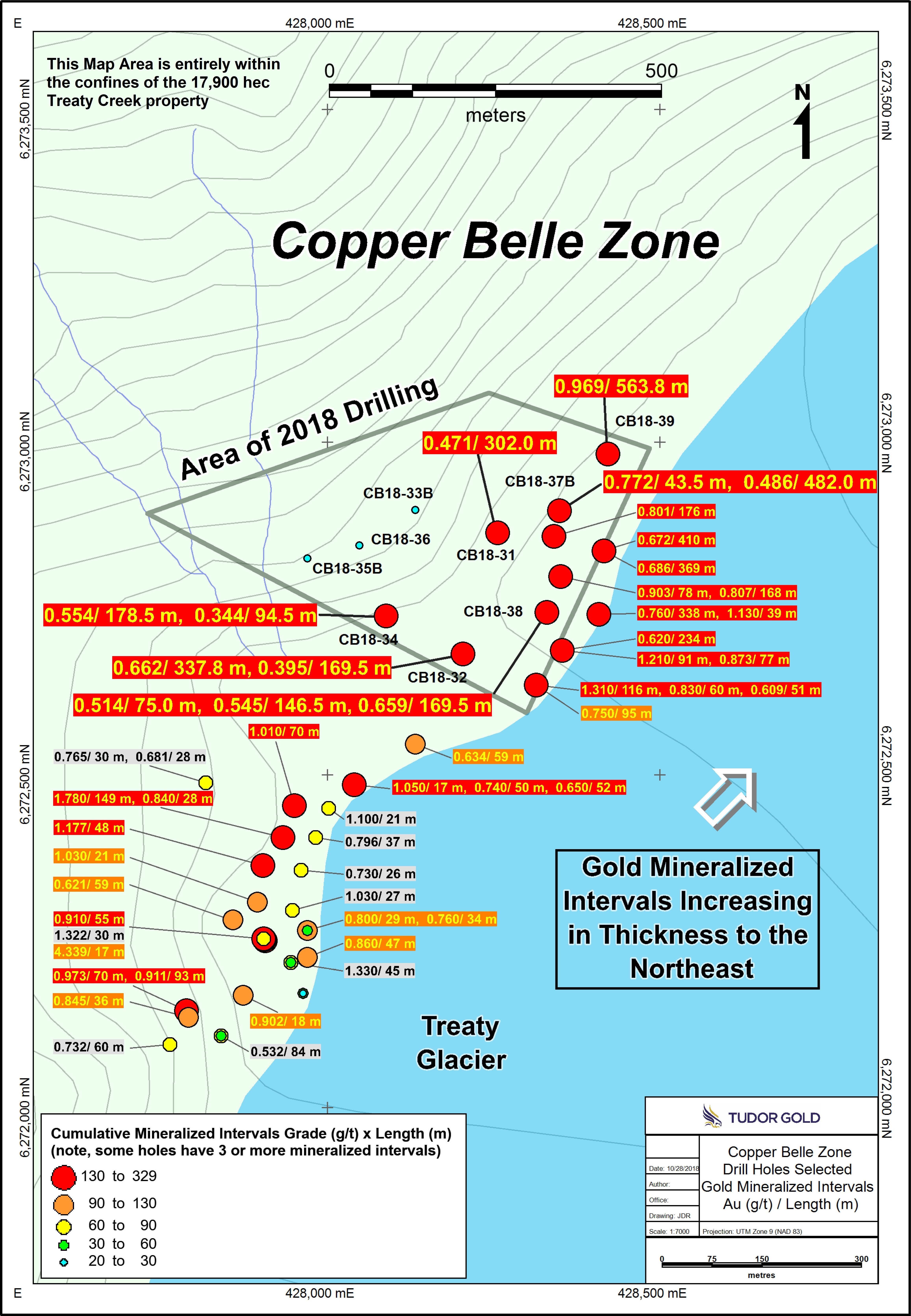
  • Final hole (CB-18-39) of the 2018 exploration season,was a 90 m step-out to the north of the Copper Belle Zone
  • Intersected 0.981 g/t gold over 563.8m, including 1.15 g/t gold over 234 m and 1.72 g/t gold over 55.5m
  • Widest and most strongly mineralized interval of the 69 holes that have been drilled within the zone

Cardston, Alberta–(Newsfile Corp. – November 26, 2018) –  American Creek Resources Ltd. (TSXV: AMK) (“American Creek”) (“the Corporation”) is pleased to report that the final hole (CB-18-39) of the 2018 exploration season, a 90 m step-out to the north of the Copper Belle Zone, intersected 0.981 g/t gold over 563.8 meters including 1.15 g/t gold over 234 m and 1.72 g/t gold over 55.5m and bottomed in mineralization. This is the widest and most strongly mineralized interval seen to date of the 69 holes that have been drilled within the zone, and more importantly, suggests potentially greater widths of mineralization continuing to the north and northeast. This new extension will be a prime target for follow-up drilling in 2019.

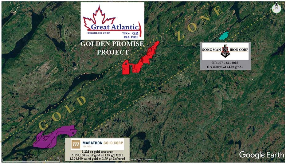
Hole CB-18-39 is one of the three holes reported here that were part of the nine-hole 2018 drill program on the Copper Belle zone of the Company’s Treaty Creek property, in the “Golden Triangle” area of north-western BC (see map below). The Treaty Creek property is adjacent to and part of the same large hydrothermal system as Seabridge’s KSM property and Pretivm’s Brucejack / Snowfield property. Results of core sampling have now been received for all of the nine holes completed. The first six holes were reported in the August 24 and October 30 news releases.

Walter Storm, President and CEO, stated: “This very positive intersection in the final hole of the year at Treaty Creek exhibits particularly strong gold values for a porphyry-style deposit. It is certainly the best result to date at Copper Belle – in terms of grade x length – being some 50% longer than the previous longest intersection. We drilled 9 deep holes in 2018, testing a large area with a wide-spaced drill pattern, a program which has expanded the Copper Belle zone to the north and northwest; discovering broad intercepts of gold mineralization adjacent to similar wide intercepts reported in 2017. The target next year will be more drilling north and northeast of Hole CB-18-39, expanding on the significant grade and scale of the gold mineralization encountered.”

Copper Belle Drill Hole CB-18-39 Mineralized Intervals

Hole ID From (m) To (m) Interval (m) Au (g/t) Ag (g/t) Cu (ppm)
CB-18-39 141.5 705.3 563.8 0.981 4.4 352.2
includes 141.5 185 43.5 1.21 2.8 171.7
and 194 428 234 1.147 6.1 501.6
and 437 474.5 37.5 0.352 2.8 84
and 483.5 519.5 36 0.641 2.1 282.4
and 530 549.5 19.5 1.071 1.8 407.7
and 560 563 3 1.243 1 167.5
and 569 624.5 55.5 1.719 10.4 348.3
and 632 660.5 28.5 1.521 2.4 330.9
and 666.5 705.3 38.8 0.673 1.5 305.1
EOH 705.3


* All assay values are uncut and intervals reflect drilled intercept lengths.
* True widths of the mineralization have not been determined.

CB-18-39 intersected mineralization from a depth of 141.5 m to the end of the hole at 705.3 m, averaging 0.981 g/t Au over 563.8 m. The hole also contained higher grade sections, such as 1.719 g/t Au, with 10.4 g/t Ag, over 55.5 m and, significantly, the hole ended in mineralization, grading 0.673 g/t Au over 38.8 m, indicating potential for continuing mineralization at depth.

CB-18-39 was drilled northwesterly at an angle of -72 degrees. The host volcaniclastic rocks are typically chlorite, sericite and locally potassically altered, however the more strongly mineralized intervals exhibit increased pyrite and stronger silicification than surrounding rocks. This hole also displayed more chalcopyrite than was observed in previous holes. This may indicate that copper grades could be increasing to the north. Silver values were also higher on average in hole CB-18-39, with sections such as 10.4 g/t Ag over 55.5 m from 569.0 m to 624.5 m.

Hole CB-18-39 is the northernmost hole drilled to date and has extended the length of the Copper Belle Zone approximately 90 m northeast from CB-18-37B, to a total known length of 1200 m. Hole CB-18-38; a fill-in hole in the east part of the drill grid, returned wide intercepts of gold mineralization similar to nearby previously drilled holes. Hole CB-18-36 was drilled at the west edge of the drill grid and gold-bearing intervals in this hole indicate that the zone continues at depth in that direction. Gold, silver and copper results for holes CB-18-38 and CB-18-36 are summarized in the table below.

Copper Belle Drill Holes CB-18-38 and CB-18-36 Mineralized Intervals

Hole ID From (m) To (m) Interval (m) Au (g/t) Ag (g/t) Cu (ppm)
CB-18-38 20.5 40 19.5 0.561 0.6 56.7
49 52 3 0.446 1.6 37.5
59.5 134.5 75 0.514 1.2 187.8
161.5 164.5 3 1.114 1.4 192
185.5 200.5 15 0.22 1.5 118.6
215.5 362 146.5 0.545 2.8 298.7
468.5 638 169.5 0.659 1.1 76.4
includes 504.5 572 67.5 1.049 1.3 98.1
686 698 12 0.54 0.8 133.4
EOH 698.0
CB-18-36 658 704.5 46.5 0.76 2.7 93.2
736 752.5 16.5 0.276 1.6 73.8
758.5 778 19.5 0.361 1.6 51.6
EOH 805.0


* All assay values are uncut and intervals reflect drilled intercept lengths.
* True widths of the mineralization have not been determined.

CB-18-38 was a fill-in hole located approximately 60 m and 140 m from the adjacent holes (see map below), providing important information about the width, grade and continuity of the Copper Belle Zone in this area. It was drilled to the northwest at an angle of -72 degrees, parallel to the adjacent holes, and returned three broad intervals of gold mineralization; 0.514 g/t Au over 75.0 m, 0.545 g/t Au over 146.5 m and 0.659 g/t Au over 169.5 m. Additional narrower intervals included 0.561 g/t Au over 19.5 m, as well as 0.540 g/t Au over 12.0 m, which extended to the end of the hole indicating that mineralization probably continues at depth.

The gold mineralized intervals in CB-18-38 are primarily hosted by andesitic tuff and fragmental rocks that are moderately silicified, with chloritic, sericitic and potassic alteration, and are cut by abundant fine pyrite veins and later quartz-carbonate veins. Pyrite content averages about 5%, occurring as fine veins, disseminations and local coarse masses in the host rocks. Gold occurs primarily within the pyritic intervals, as well as within later quartz veins, along with rare chalcopyrite, galena and sphalerite.

CB-18-36 was located at the west edge of the drill grid, and oriented to the northwest at an angle of -72 degrees. It intersected a wide zone of faulting and brecciation that has undergone sericite alteration, with overprinted strong silicification and abundant pyrite. This fault zone, plus underlying brecciated volcanic rocks, is mineralized over a drilled length of more than 140 m, and contains a more strongly mineralized gold zone averaging 0.760 g/t Au over a thickness of 46.5 m. Later quartz-carbonate veins containing pyrite, with lesser galena and sphalerite may also contribute to the gold grades.

The nine holes drilled in 2018 covered an area measuring approximately 370 meters by 250 meters, to depths ranging from 600 to 900 meters. This area is located to the north and west of the area for which the company reported a range of 1.8 to 1.9 million ounces contained within 50 to 45 million tonnes grading 1.12 to 1.35 g/t Au determined from the drill results prior to 2018.

The most recent drilling has now extended the known length of the porphyry-style mineralized system for over 1200 meters. For locations of the 2018 and other holes in the Copper Belle area please view the map below. The Copper Belle zone has an elongate north-northeast trend, dipping at a relatively flat angle to the northwest. Mineralization appears to be related to an extensive north-northeast trending tectonic zone that may be part of the extensive Sulphurets Thrust Fault structure that also traverses the KSM property to the south.

The objective of the 2018 drill program was to better define the extent of the Copper Belle zone. The results from the 2018 holes have provided additional information about continuity and grade of mineralization that, along with the previous drill results, will be integral for a resource calculation.

Darren Blaney, CEO of American Creek stated: “Drilling has continued to show long intervals of one-gram gold including lenses of higher grade within. The mineralization is open at depth and to the north-north east just as indicated by the geophysics, which also indicates that we’re only scratching the surface of highly prospective areas on Treaty Creek. What has been rewarding is that the geology and geophysics, both similar to Seabridge’s KSM and Pretivm’s Snowfield, have been used together to guide the drill to such exceptional results.”

Cannot view this image? Visit: https://orders.newsfilecorp.com/files/682/41235_62180926f4bd1bdb_001.jpg

Figure 1: Copper Belle Drill Hole Locations and Composite Mineralized Intervals

To view an enhanced version of Figure 1, please visit:
https://orders.newsfilecorp.com/files/682/41235_62180926f4bd1bdb_001full.jpg

QAQC

Drill core samples were prepared at ALS Global’s (independent) Preparation Laboratory in Terrace, BC and assayed at ALS Global’s (independent) Geochemical Laboratory in North Vancouver, BC. Analytical accuracy and precision are monitored by the submission of blanks, certified standards and duplicate samples inserted at regular intervals into the sample stream by Tudor Gold personnel. ALS Global Laboratories quality system complies with the requirements for the International Standards ISO 17025: 2005.

QP

The Qualified Person for the Treaty Creek results in this new release is James A. McCrea, P.Geo., for the purposes of National Instrument 43-101. He has read and approved the scientific and technical information that forms the basis for the disclosure contained in this news release.

Gold Hill Drill Program

The Corporation reports that the previously announced exploration/drill program on the Gold Hill project located in the Wildhorse (Boulder) watershed in SE British Columbia is still underway and is proceeding as planned. Core is being logged, split and sampled and the first batch of samples is expected to be shipped to the assay lab this week.

Cannot view this image? Visit: https://orders.newsfilecorp.com/files/682/41235_62180926f4bd1bdb_002.jpg

To view an enhanced version of this graphic, please visit:
https://orders.newsfilecorp.com/files/682/41235_62180926f4bd1bdb_002full.jpg

A summary of the Gold Hill project can be found here:
https://americancreek.com/images/Gold_Hill_Summary_2018.pdf

A short video on the Gold Hill property can be found here:
https://americancreek.com/index.php/news/news-2018/377-2

About American Creek

American Creek holds a strong portfolio of gold and silver properties in British Columbia.

Three of those properties are located in the prolific “Golden Triangle”; the Treaty Creek and Electrum joint venture projects with Tudor (Walter Storm) as well as the 100% owned past producing Dunwell Mine.

The Corporation also holds the Austruck-Bonanza, Ample Goldmax, Silver Side, and Glitter King properties located in other prospective areas of the province.

For further information please contact Kelvin Burton at: Phone: 403 752-4040 or Email: [email protected]. Information relating to the Corporation is available on its website at www.americancreek.com