Posted by AGORACOM
at 2:17 PM on Tuesday, May 21st, 2019
Aiming to become a Wollastonite producer focused on delivering high quality products to multiple industries.
WOLLASTONITE
St-Onge-Wollastonite Deposit located approximately 90 kilometres Northwest of the city of Saguenay, in St-Onge township, in the Saguenay-Lac-St-Jean region of Quebec, Canada.
Research and testing in the Phase 1 program for use in cannabis growth was managed and monitored by AGRINOVA, a highly-regarded Center for Research and Innovation in Agriculture in Quebec
St-Onge-Wollastonite Deposit:
Utilizing Wollastonite as A Soil Additive
Vertical is researching the use of Wollastonite as a soil additive for optimizing marijuana growth
Phase
Three trials involving cannabis grown with wollastonite (CaSiO3) as a
soil additive at BC Bud Depot’s (BCBD) ACMPR-licenced Research and
Development facilities in Vancouver, BC
Phase Three trials measured and recorded significant improvements in root mass, powdery mildew control and pest elimination.
In every case the most optimal results occurred with an admixture rate of 10% to 15% wollastonite to the growth medium
Hub on Agoracom FULL DISCLOSURE: Vertical Exploration is an advertising client of AGORA Internet Relations Corp.
Posted by AGORACOM
at 9:54 AM on Friday, May 3rd, 2019
Primary exploration target within Treaty Creek is the Goldstorm system.
The Goldstorm zone is located five kilometers northeast of Seabridge’s Iron Cap Deposit.
The Goldstorm mineralized body can be traced for at least 500 meters along strike.
20 diamond drill holes totaling 14,000 meters of drilling are planned
Cardston, Alberta–(Newsfile Corp. – May 3, 2019) – American Creek Resources Ltd.
(TSXV: AMK) (“the Corporation”) is pleased to announce that JV partner
Tudor Gold (“Tudor”) has announced the 2019 exploration plans for its
flagship property, the Treaty Creek project located in the Golden
Triangle of NW British Columbia.
The primary exploration target
within Treaty Creek is the Goldstorm system. From the southwest corner
of the Treaty Creek claims, which are bordering Seabridge’s claims, the
Sulphurets Thrust Fault leads from Seabridge’s Iron Cap Deposit to
Tudor’s Goldstorm system. This regional thrust fault sharply defines the
hanging wall contact of both the Iron Cap Deposit and the Goldstorm
zone. The Goldstorm zone is located five kilometers northeast of
Seabridge’s Iron Cap Deposit.
Map showing Sulphurets fault extending through Goldstorm zone.
The
Goldstorm mineralized body can be traced for at least 500 meters along
strike. The gold mineralization appears to be confined to the northwest
by what appears to be the Sulphurets Thrust Fault, however gold
mineralization remains open in all other directions and is open to depth
as well.
Ken Konkin, P.Geo. Tudor’s Exploration Manager, provided details on Tudor’s exploration plans and objectives for Treaty Creek:
“For
the 2019 exploration season we have planned 20 diamond drill holes
totaling 14,000 meters of drilling, subject to the Company having
sufficient cash resources to fund the ongoing program. Tudor Gold plans
to use two diamond drill rigs. The first phase of drilling will include
3,600 meters of drilling with five planned drill holes. The goal is to
trace-out the gold mineralization to the footwall contact and to
continue drilling to extend the zone to the northeast 200 meters beyond
drill hole CB18-39 (0.981 gpt Au over 563.8m) (See news release of
November 26, 2018). The gold system appears to be at least 300 meters
wide and at least 700 meters deep, however the strongest mineralized
horizons occur near surface in the uppermost parts of the mineralized
body. In order to fast-track the exploration process, step-out drilling
along strike is proposed in 200 meter sections. We believe that this
approach is the most efficient way to outline the size and shape of the
target.”
Walter Storm, President and CEO of Tudor stated: “We are
fortunate to have someone with such vast geological experience as Ken
Konkin as Tudor Gold’s Exploration Manager. Our management team is very
confident with Ken’s abilities and he will personally manage all aspects
of the drill program. His preliminary work has been outstanding in
defining and prioritizing drill targets.”
Darren Blaney, CEO of
American Creek stated: “The much anticipated 2019 exploration program at
Treaty Creek is rapidly approaching. We are very optimistic that the
proposed expanded drilling program building on that spectacular last
hole from 2018, CB18-39 will continue to show extensive gold
mineralization. We have the utmost confidence in Mr. Konkin’s expertise
and ability as his amazing track record speaks for itself.”
The following video shows the drill hole collar locations with proposed drill hole traces.
The
Qualified Person for this news release for the purposes of National
Instrument 43-101 is Ken Konkin, P.Geo. He has read and approved the
scientific and technical information that forms the basis for the
disclosure contained in this news release.
The Treaty Creek
Project is a joint venture between Tudor Gold, American Creek Resources,
and Teuton Resources Corp. Tudor is the operator and holds a 60%
interest with both American Creek and Teuton each holding respective 20%
carried interests in the property (fully carried until a production
notice is given).
For more information about Treaty Creek click here.
About American Creek
American
Creek is a Canadian junior mineral exploration company with a strong
portfolio of gold and silver properties in British Columbia. Three of
those properties are located in the prolific “Golden Triangle”; the
Treaty Creek and Electrum joint venture projects with Tudor Gold/Walter
Storm as well as the 100% owned past producing Dunwell Mine.
The
Corporation also holds the Gold Hill, Austruck-Bonanza, Ample Goldmax,
Silver Side, and Glitter King properties located in other prospective
areas of the province.
For further information please contact Kelvin Burton at: Phone: 403 752-4040 or Email: [email protected]. Information relating to the Corporation is available on its website at www.americancreek.com
Posted by AGORACOM
at 9:41 AM on Friday, May 3rd, 2019
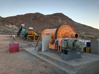
The Company has been advancing the Graphite Project on three fronts
Exploration and diamond drilling
Construction of on-site offices, laboratory, and living quarters,
Construction of a commercial scale graphite processing plant capable of producing 20,000 tonnes of concentrate per year,
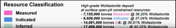
TORONTO, May 3, 2019 /CNW/ – Gratomic Inc. (“Gratomic” or the “Company”) (TSX-V: GRAT) (CB81–FRANKFURT) a vertically integrated graphite to graphene, advanced materials development company is pleased to provide an update from its Aukam Graphite Mine in Namibia. The Company has been advancing the Graphite Project on three fronts focusing on exploration and diamond drilling, construction of on-site offices, laboratory, and living quarters, and the construction of a commercial scale graphite processing plant. The commercial scale graphite plant, capable of producing in excess of 20,000 tonnes of graphite concentrate per year, will replace the existing pilot plant commissioned in 2018 which successfully produced 5.5 tonnes of graphite concentrate grading between 88%-96% Carbon as Graphite (“Cg”).
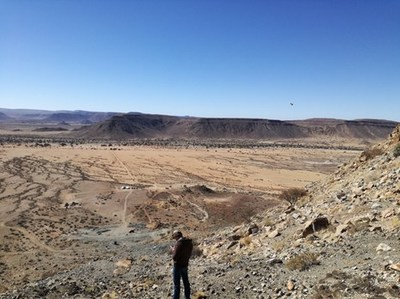
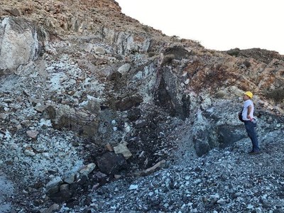
The Aukam Graphite Project is located in southern Namibia
close to the port city of Luderitz. The property hosts five underground
adits which were mined periodically between 1940 and 1974. Graphite
mineralization at Aukam is of the vein or lump type and occurs as
massive lenses and veins. Graphite has also been observed as minor
disseminated patches hosted in variably altered granite.
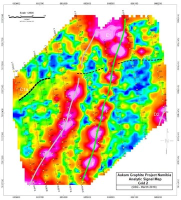
2018 Exploration
During 2018, Gratomic contracted Gregory Symons Geophysics (GSG) to
perform Horizontal Loop Electromagnetics (HLEM) and magnetic surveys in
continuation of previous geophysical surveys undertaken in 2016/2017.
The original survey was performed in the vicinity of the Aukam Mine
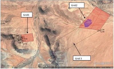
marked by the black polygon in Figure1 below. During the 2018
geophysical survey, ground electromagnetic and magnetic surveys were
completed in two areas identified as Grid 1, which lies East of the
Aukam Mine, and a portion Grid 2 as indicated in purple, known as Snyman
Graphite Occurrence (see Figure 1).
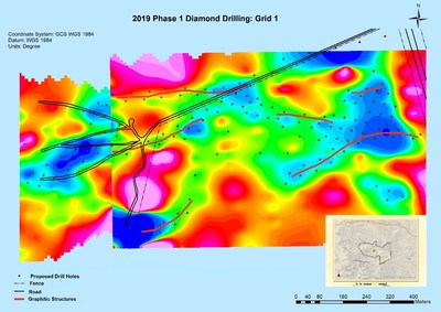
Grid 1 adjoins the previous survey over the mine area at Aukam
and extends the strike length covered to 1.6 kilometres to the East.
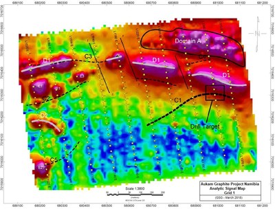
Significant interpretations pertaining to Grid 1 include:
Graphite identified at surface occurs both as
massive graphite veins and widespread disseminated graphite over an area
of 550 metres east-west by 190 metres north- south,
Surface graphite showings are located sub-parallel to known electromagnetic anomalies,
Electromagnetic anomalies extend those depicted by the original survey by approximately 550 metres,
Current strike length of anomaly now stands at 1.3 kilometres,
Distinct drill targets have been identified along the trend (see Figure 2),
Surveyed area appears to be under rather shallow sand cover,
Prospective areas identified are conducive to surface trenching.
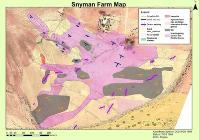
Grid 2 of the completed geophysical survey covers the Snyman
graphite occurrence in the northeastern portion of EPL3895. The Snyman
graphite occurrence covers an area of 7.5 ha and lies approximately 6.5
kilometres east of the Aukam mine.
Significant interpretations pertaining to Grid 2 include:
Graphitic interpreted mineralization is depicted by a
predominant EM anomaly in the northwest part of the grid extending over
150 metres,
A second weaker EM further to the east extends
over 600 metres is thought to be associated with graphite mineralization
in the area
The grid area appears to be covered with thin overburden,
Areas have been identified as prospective areas conducive to surface trenching (see Figure 3)
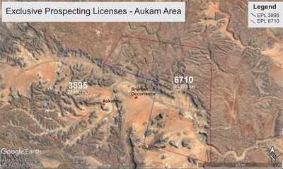
During 2018 Gratomic was granted additional Exclusive
Prospecting License, Number 6710 (EPL 6710) by the Namibian Ministry of
Mines and Energy, with an initial exclusivity of three years. The
license area is contiguous with EPL 3895, which covers the Aukam
graphite deposit and the Snyman graphite occurrence (see Figure 4). The
application for EPL 6710 was submitted in order to cover the potential
strike extension of the Snyman graphite occurrence to the east. In
addition, EPL 6710 covers an additional area considered prospective for
graphite within the “Aukam window” where rocks hosting the Aukam and
Snyman graphite are exposed beneath the regional unconformity at the
base of the Nama Group sedimentary rocks. The addition of the new EPL
increases the area of prospective geology covered to 63,072 hectares
(630 square kilometres).
Regional exploration in 2018 included mapping and sampling of
graphite occurrences throughout the Company’s license areas with
emphasis on the 400 hectares encompassing both the Snyman graphite
occurrence and the area east of the Aukam Mine. Compilation,
interpretation and presentation of all available geologic data allowed
for subsequent diamond drill targeting with initial drilling planned for
the area immediately east of the existing underground workings of the
Aukam Mine.
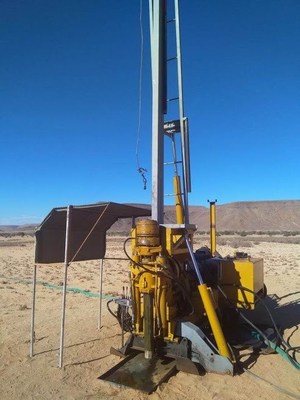
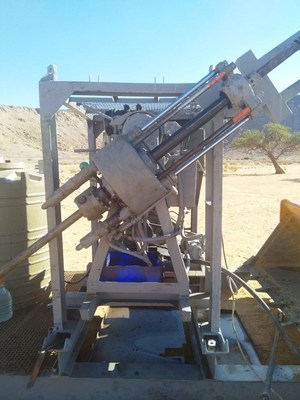
Diamond Drilling
Two company drills were deployed to Aukam in March 2019
with diamond drilling commencing in April. The company is currently
operating a Longyear 38 with a 2-cylinder XY-1 drill for a backup.
Initial targets being drilled are proximal to the Aukam Mine and are
spaced at 25 metres with infill drill planned to follow based on
results. Five holes have been completed at the time of this release.
Processing Plant
During 2018 Gratomic completed the construction and start-up of its’
prototype processing plant to test and refine the processes that will be
used for commercial production. The Aukam processing plant uses a
simple crushing, grinding and flotation system. Graphite feed for the
prototype plant was obtained from screening and sorting of existing
stockpiles from historical mining. The processing plant operated for 26
days during April and for all 31 days in May of 2018. While operational,
data was collected at each phase of the process and test results from
samples were sent to Gecko labs with the subsequent results used to
optimize plant processes. The following tests and optimization were
conducted:
Liberation analysis
Flake size distribution analysis
Mixing velocity optimization
Screen size analysis and optimization
Air flow analysis in columns and optimization
Drying analysis and optimization
Silica dispersant ratio optimization
Reagent optimization
Product flow rate optimization
Grade optimization
Staff recruitment, training, and man-hour analysis
Economic sensitivity analysis on pilot processing facility
Feed stock optimization and process
The
Company continued to optimize the pilot plant processing stockpiled
graphite mineralization throughout 2018. To date, the plant has
processed 9 tonnes of the graphite mineralization with 5.5 tonnes of
graphite concentrate grading between 88% and 96% Cg shipped to Perpetuus
Carbon Technologies (“Perpetuus”) for the manufacture of graphene to be
used in the automobile and bicycle tire industry. Graphene made from
Aukam graphite continues to be tested in Europe and Asia with good results.
Gratomic and Perpetuus are currently in collaboration to build on
Perpetuus’ capability to produce high quality surface modified graphene
in support of the anticipated volumes required by the tire manufacturing
industry. Additional applications that have now been generated in a
preproduction format include radiant heating membranes and super
hydrophobic coatings with an addressable market that include; graphene
inks, marine, oil & gas, power generation, industrial (repair &
maintenance), infrastructure (new build) and automotive &
transportation among others.
Plant Expansion
Plant expansion to increase capacity to 20,000 tonne per annum began
in2018. Initial activities included construction of a platform for
drying graphite product and of a washing bay for equipment, complete
with a containment system to collect impacted water. Steel drying pans,
an oven, and two screens were also assembled and successfully
tested. Continued upgrades involved the extension of the working area on
the pilot plant by another 35 metres to the north-west to accommodate
new crushing equipment and conveyer belts. Analysis of all plant
processes continues to optimize efficiencies of each process such as rod
mills, flotation columns, and reagent introduction. Four different
tests were run with the first test being used as a base line. Samples
were taken from the rod mill feed, mill discharge, and screen
under-and-over size. Calculations were made to determine the amount of
chemicals needed to be introduced into the mixers according to the
density and volume of the mixer feed.
Recent upgrades to the processing plant continue with the arrival of
additional commercial scale equipment including; industrial sized
generator, screw conveyors, shaker screens, rod mill, conveyors, and
boom truck.
Gratomic is continuing with its systematic assembly of the commercial scale graphite processing plant. Next steps will include:
Completion of the pilot acid wash. This circuit will
be used to collect engineering data to design the commercial scale
plant. This is an addition to the plant that will allow the company to
produce upwards of 98.5% graphite based on its latest pilot testing
results in the lab.
Modifications are currently being made to the jaw crusher to allow it to more effectively crush graphite,
Rod
mill support systems such as maintenance cradles and cranes, rod
loading equipment and control systems are currently being engineered,
Flotation
circuit mass balances are being explored using pilot plant data in
order to size the pumps and flow lines of the flotation system,
Dewatering circuit equipment are currently being specified,
Water
conditioning systems are currently being designed to allow close to
100% recycle of water. This includes pH control, removal of fine
suspended solids and removal of dissolved iron,
Control systems are being designed for each sub-circuit of the commercial scale plant.
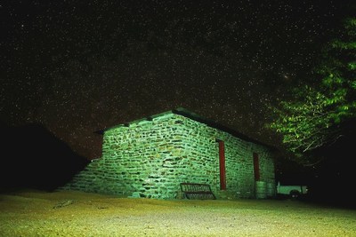
Camp Construction
Construction of the onsite Management Camp consisting of offices,
laboratory, kitchen, and living quarters, is ongoing. Work began with
two of the larger structures during Q4/2018.
Qualified Persons
Steve Gray, P.Geo. has reviewed,
prepared and approved the scientific and technical information in this
press release and is Gratomic Inc’s “Qualified Person” as defined by
National Instrument 43-101 – Standards of Disclosure for Mineral Projects.
About Gratomic Inc.
Gratomic is an advanced materials company focused on mine to market
commercialization of graphite products most notably high value
graphene-based components for a range of mass market products. We are
collaborating with a leading European manufacturer of graphene to use
Aukam graphite to manufacture graphene products for commercialization on
an industrial scale. The company is listed on the TSX Venture Exchange
under the symbol GRAT.
“Neither TSX Venture Exchange nor its Regulation Services Provider
(as that term is defined in the policies of the TSX Venture Exchange)
accepts responsibility for the adequacy or accuracy of this release.”
Posted by AGORACOM
at 8:34 AM on Wednesday, March 13th, 2019
Labrador Gold controls 57 kilometre a strike length of stratigraphy prospective for gold in the Florence Lake Greenstone Belt. Hopedale Project
Exploration program at Hopedale followed up on successful results of 2017 work that outlined regional scale gold in soil and lake sediment anomalies
Of these samples, 80 assayed greater than 0.1 g/t gold including 17 samples that assayed greater than 1 g/t gold.
VANCOUVER,
British Columbia, March 13, 2019 (GLOBE NEWSWIRE) — Labrador Gold
Corp. (TSX-V: LAB) (“Labrador Gold†or the “Companyâ€) is pleased to
announce assay results for rock samples from its Hopedale project in
Labrador. The company controls a 57 kilometre strike length of
stratigraphy prospective for gold in the Florence Lake Greenstone Belt.
The exploration program at Hopedale followed up on successful results of
2017 work that outlined regional scale gold in soil and lake sediment
anomalies along the length of the belt and included detailed soil
sampling, geological mapping, rock sampling and prospecting.
A
total of 588 rock samples were taken along the length of the Florence
Lake Greenstone Belt during the regional prospecting and mapping
program. Of these samples, 80 assayed greater than 0.1 g/t gold
including 17 samples that assayed greater than 1 g/t gold. Results of
the assays ranged from below the detection limit of 0.05 g/t to 11.4 g/t
gold in a grab sample from a quartz vein with pyrite and arsenopyrite.
Additional highlights include channel samples of 2.77 g/t gold over 2.1
metres and 2.37 g/t gold over 2 metres. Highlights of gold assays of
grab samples include 4.55g/t gold from quartz porphyry and 2.52g/t and
2.46g/t gold from quartz veins that were altered or contained sulphide.
Complete highlights of the program are shown in the table below.
Sample ID
Area
Sample Type*
Length
Au g/t
Description
1685504 to 506
Thurber Dog
Channel
3.5
0.47
Quartz veins in Quartz porphyry
1685506
Thurber Dog
including
1
0.86
Quartz Porphyry
1685509 to 510
Thurber Dog
Channel
2
0.91
Felsic volcanic
1685509
Thurber Dog
including
1
1.27
Quartz vein
1685555 to 556
Thurber North
Channel
2
2.36
Quartz Porphyry
1685556
Thurber North
Including
1
2.73
Quartz Porphyry
1685566
Thurber North
Channel
0.5
0.92
Ferruginous quartz vein
1685589
Thurber North
Channel
0.56
0.48
Quartz vein with iron Carbonate
1685613
Thurber South
Channel
1.2
0.65
Carbonate altered mafic volcanic
1685632 to 633
Thurber South
Channel
2.1
2.77
Chlorite altered Mafic volcanic with quartz veins
1685632
Thurber South
including
1.2
3.99
Quartz vein with Fe oxide
1693835
Thurber Dog
Grab
n/a
1.01
Quartz vein with Arsenopyrite
1685854
Shirley
Grab
n/a
1.09
Phyllite with arsenopyrite
1690808
Thurber Dog
Grab
n/a
1.45
Felsic volcanic/Quartz Porphyry
1692276
Thurber South
Grab
n/a
1.64
Quartz Vein
1692279
Thurber South
Grab
n/a
1.74
Quartz Vein
1693836
Thurber North
Grab
n/a
1.84
Silicified ultramafic with quartz veining and arsenopyrite
1685851
Shirley
Grab
n/a
2.46
Quartz-carbonate vein with pyrite
1692283
Thurber South
Grab
n/a
2.52
Quartz vein with iron carbonate
1656525
Thurber North
Grab
n/a
4.55
Quartz porphyry
1693833
Thurber Dog
Grab
n/a
11.40
Quartz vein with pyrite and arsenopyrite
*Note that grab samples are select samples and are not necessarily representative of gold mineralization found on the property.
While
rock samples containing anomalous gold are found in many parts of the
greenstone belt, most of the samples above 0.1g/t gold occur in the
Jasmine/Shirley and Thurber Dog areas of the belt. At Jasmine/Shirley,
the gold mineralization is associated with altered mafic volcanic rocks
and phyllite that contain varying amounts of arsenopyrite from
disseminated grains to veins of massive arsenopyrite. The highest-grade
rocks in the area are from quartz veins with iron carbonate alteration.
At
Thurber Dog, gold mineralization is associated primarily with altered
porphyritic felsic volcanic rocks and quartz veins around the Thurber
Dog occurrence and in the Thurber North area. At Thurber South the
mineralization is associated with intensely carbonate altered ultramafic
and mafic volcanic rocks and associated quartz veins. The mineralized
rocks typically contain disseminated pyrite and, more rarely
arsenopyrite.
“The results of our prospecting
at Hopedale are very encouraging, especially since this was our first
systematic rock sampling of the greenstone belt.†said Roger Moss,
President and Chief Executive Officer of Labrador Gold. “Over 13% of the
samples taken along the length of the belt returned results of more
than 0.1 g/t gold and will be followed up in detail. In addition,
significantly anomalous gold mineralization previously identified over a
three kilometre strike length in the Thurber Dog portion of the belt
continues to show excellent potential.â€
All
samples were shipped to the Bureau Veritas preparation laboratory in
Timmins, Ontario, where they were crushed and split and a 500g sub
sample pulverized to 200 mesh. Pulps were sent to the Vancouver
laboratory for assay. Samples of 30g were analyzed for gold by fire
assay with an atomic absorption finish and another 15g sample for 36
elements by ultratrace ICP-MS (inductively coupled plasma-mass
spectrometry) following an aqua regia digestion. Overlimit samples
(greater than 10g/t Au) are re-assayed using fire assay with a
gravimetric finish. In addition to the QA-QC conducted by the
laboratory, the Company routinely submits blanks, field duplicates and
certified reference standards with batches of samples to monitor the
quality of the analyses.
Roger Moss, PhD., P.Geo., is the qualified person responsible for all technical information in this release.
The
company gratefully acknowledges the Newfoundland and Labrador Ministry
of Natural Resources’ Junior Exploration Assistance (JEA) Program for
its financial support for exploration of the Hopedale property.
About Labrador Gold:
Labrador
Gold is a Canadian based mineral exploration company focused on the
acquisition and exploration of prospective gold projects in the
Americas. In 2017 Labrador Gold signed a Letter of Intent under which
the Company has the option to acquire 100% of the 896 square kilometre
(km2) Ashuanipi property in northwest Labrador and the Hopedale (458 km2) property in eastern Labrador.
The
Hopedale property covers much of the Hunt River and Florence Lake
greenstone belts that stretch over 80 km. The belts are typical of
greenstone belts around the world but have been underexplored by
comparison. Initial work by Labrador Gold during 2017 show gold
anomalies in soils and lake sediments over a 3 kilometre section of the
northern portion of the Florence Lake greenstone belt in the vicinity of
the known Thurber Dog gold showing where grab samples assayed up to
7.8g/t gold. In addition, anomalous gold in soil and lake sediment
samples occur over approximately 40 kilometres along the southern
section of the greenstone belt (see news release dated January 25th 2018 for more details). Labrador Gold now controls approximately 57km strike length of the Florence Lake Greenstone Belt.
The
Ashuanipi gold project is located just 35 km from the historical iron
ore mining community of Schefferville, which is linked by rail to the
port of Sept Iles, Quebec in the south. The claim blocks cover large
lake sediment gold anomalies that, with the exception of local
prospecting, have not seen a systematic modern day exploration program.
Results of the 2017 reconnaissance exploration program following up the
lake sediment anomalies show gold anomalies in soils and lake sediments
over a 15 kilometre long by 2 to 6 kilometre wide north-south trend and
over a 14 kilometre long by 2 to 4 kilometre wide east-west trend. The
anomalies appear to be broadly associated with magnetic highs and do not
show any correlation with specific rock types on a regional scale (see
news release dated January 18th 2018). This suggests a
possible structural control on the localization of the gold anomalies.
Historical work 30 km north on the Quebec side led to gold intersections
of up to 2.23 grams per tonne (g/t) Au over 19.55 metres (not true
width) (Source: IOS Services Geoscientifiques, 2012, Exploration and
geological reconnaissance work in the Goodwood River Area, Sheffor
Project, Summer Field Season 2011). Gold in both areas appears to be
associated with similar rock types.
The Company has 56,264,022 common shares issued and outstanding and trades on the TSX Venture Exchange under the symbol LAB.
Posted by AGORACOM
at 9:57 AM on Wednesday, February 27th, 2019
Received all analytical results from the 2018 exploration program at its Golden Promise Property, located in the central Newfoundland gold belt
The results identified additional exploration targets where no prior drilling has taken place
VANCOUVER, BC / ACCESSWIRE / February 27, 2019 / GREAT ATLANTIC RESOURCES CORP. (TSXV.GR) (the “Company” or “Great Atlantic”) is pleased to announce it has received all analytical results from the 2018 exploration program at its Golden Promise Property, located in the central Newfoundland gold belt, the results identifying additional exploration targets. The 2018 soil and rock analytical results confirm gold soil anomalies +/- rock samples anomalous in gold in at least three additional target areas in under-explored regions of the property. The Company’s main focus on the property remains the Jaclyn Zone where multiple gold bearing quartz vein systems occur. Gold bearing veins and gold bearing quartz vein boulders occur in other regions of the property.
Anomalous 2018 rock and soil samples were concentrated in three new targets areas:
Southwest
region: Anomalous soil samples along two reconnaissance soil lines, up
to 77 ppb gold (News Release of September 27, 2018). All 11 samples
along one 570- meter long line returned anomalous gold values. Rock
samples within the soil anomaly retuned anomalous gold values including
1.04 g/t gold.
East-Central region:
Anomalous soil samples (up to 39 ppb gold) & rock float samples (up
to 136 ppb gold) along a reconnaissance traverse.
West-Central
region: Anomalous soil samples (up to 41 ppb) following up in an area
of 2017 soil anomalies (212 and 236 ppb gold).
No previous drilling in the new target areas.
The
2018 program was reconnaissance in nature consisting of prospecting and
soil / rock geochemical sampling in multiple under-explored regions of
the Golden Promise Property. Multiple gold soil anomalies were
identified in the southwest, west-central and east-central regions of
the property, thereby adding to the number of gold targets within the
property. Rock grab samples from float in the east-central and southwest
regions of the property returned anomalous values for gold, the high
value being 1.04 g/t gold.
Soil sample analytical results from the
southwest region of the Golden Promise Property were reported in the
Company’s News Release of September 27, 2018. The
results include anomalous gold in soil samples from a new target area in
this southwest region. The majority of soil samples from two
reconnaissance lines in this target area returned anomalous values for
gold (up to 77 parts per billion (ppb) gold) including all 11 samples
from one approximately 570-meter long line. Nine of the 2018 rock grab
samples (float and outcrop) from this anomalous zone returned anomalous
gold values, the high value being a boulder sample with quartz veins
returning 1.04 g/t gold.This anomalous zone is
approximately 4 kilometers northeast of the Linda / Snow White gold
bearing vein which is located within the southwest region of the
property. Reported historic highlights for the Linda / Snow White vein
include a 232 g/t gold grab sample, 29.7 g/t gold over 0.5 meters in a
channel sample and 19.5 g/t gold over 1.15 meters during diamond
drilling (core length).
Quartz boulder in new southwest target area
The
2018 program confirmed an area of gold soil anomalies in the
west-central region of the property. Initial reconnaissance soil
sampling by the Company in this region during 2017 identified gold
anomalies (including samples returning 212 and 236 ppb gold). Soil
sampling in this area was continued during 2018 along 2 north-south
lines. Six of seven soil samples from an approximately 300-meter long
section of one line returned anomalous values for gold in the 8-41 ppb
gold range, confirming this new target area. This zone of gold soil
anomalies is located approximately 1 kilometer northwest of the gold
bearing Shawn’s Shot quartz vein. A 0.32-meter long chip sample
collected by the Company across the Shawn’s Shot vein in 2017 returned
48.2 g/t gold (News Release of August 28, 2017).
The 2018 program
established a new gold target area in the east-central region of the
property. Prospecting and soil sampling were conducted along one
east-west reconnaissance line in this region. Approximately 25% of the
soil samples along an approximately 2-kilometer section of this line
returned anomalous values for gold (6-39 ppb gold). Rock samples from
quartz boulders in this region returned anomalous values for gold (up to
136 ppb gold). The target area is approximately 2.2 kilometers
south-southwest of the gold bearing Jaclyn Main Zone. The Jaclyn Main
Zone has been the primary focus of historic gold exploration on the
property.
The Company recently reported a National Instrument
43-101mineral resource estimate for the Jaclyn Main Zone, located in the
northern region of the property (News Release of December 6, 2018; and
Sedar-filed National Instrument 43-101 Technical Report on the Golden
Promise Property, Central Newfoundland (revised), dated December 4, 2018
by Mr. Greg Z. Mosher, M.Sc. App., P.Geo., and Mr. Larry Pilgrim,
B.Sc., P.Geo.). The reported inferred mineral resource estimate for the
Jaclyn Main Zone is as follows:
Resource
Cutoff Au g/t
Au Cap g/t
Au Uncap g/t
Tonnes
Au Ounces Capped
Au Ounces Uncapped
Total
1.1
9.3
10.4
357,500
106,400
119,900
Pit-Constrained
0.6
11.4
14.1
157,300
57,800
71,200
Underground
1.5
7.5
7.6
200,200
48,600
48,700
Mineral Resources are not Mineral Reserves and do not have demonstrated economic viability.
There is no certainty that all or any part of the Mineral Resources estimated will be converted into Mineral Reserves.
Mineral
resource tonnage and contained metal have been rounded to reflect the
accuracy of the estimate, and numbers may not add due to rounding.
Mineral resource tonnage and grades are reported as undiluted.
Contained Au ounces are in-situ and do not include recovery losses
The
Jaclyn Main Zone is part of the Jaclyn Zone. At least 5 gold bearing
quartz vein systems are reported at the Jaclyn Zone, including the
Jaclyn Main Zone, Jaclyn North Zone, Jaclyn South Zone, Jaclyn East Zone
and Jaclyn West Zone. Much of the reported historical exploration
within the property has been focused on the Jaclyn Zone with the
majority of historic drill holes (2002-2010) at the Jaclyn Main Zone.
Other gold bearing veins within the property include Shawn’s Shot, Linda
/ Snow White and at the Gabbro Occurrence. High grade quartz boulders
are reported within the property including at the Jaclyn Zone and
Branden and Justin’s Hope boulder occurrences.
The property is
located within the Exploits Subzone of the Newfoundland Dunnage Zone.
Within the Exploits Subzone, the property lies along the
north-northwestern fringe of the Victoria Lake Supergroup (VLSG), a
volcano-sedimentary terrane. The northwestern margin of the Golden
Promise Property occurs proximal to, and, in part, contiguous with a
major (Appalachian-scale) collisional boundary, and suture zone, known
as the Red Indian Line (RIL). The RIL forms the western boundary of the
Exploits Subzone. Recent significant gold discoveries in this region of
the Exploits Subzone include those of Sokoman Iron Corp. (TSXV.SIC) at the Moosehead Project and Marathon Gold Corp. (TSXV.MOZ) at the Valentine Lake Gold Camp.
Sokoman Iron Corp. (TSXV.SIC) recently
announced a high-grade gold discovery on its Moosehead Property,
located approximately 40 kilometers east-northeast of the Golden Promise
Property. The discovery was made during the 2018 diamond drilling
program. A drill intersection of 44.96 g/t gold over 11.90 meters core
length was reported including a 1.35 meters core length quartz vein
intersection of 385.85 g/t gold (Sokoman Iron Corp. News Release of July
24, 2018). The Valentine Lake Gold Camp of Marathon Gold Corp. (TSXV.MOZ) is
located approximately 55 kilometers southwest of the Golden Promise
Property. As reported on Marathon’s website, the Valentine Lake Gold
Camp currently hosts four near-surface, mainly pit-shell constrained,
deposits with measured and indicated resources totaling 2,691,400 oz. of
gold at 1.85 g/t gold and inferred resources totalling 1,531,600 oz. of
gold at 1.77 g/t. Readers are warned that mineralization at the
Moosehead Property and Valentine Lake Gold Camp is not necessarily
indicative of mineralization on the Golden Promise Property.
As
reported in the National Instrument 43-101 Technical Report on the
Golden Promise Property, Central Newfoundland (revised), dated December
4, 2018 by Mr. Greg Z. Mosher, M.Sc. App., P.Geo., and Mr. Larry
Pilgrim, B.Sc., P.Geo., the Jaclyn Main Zone was modelled as a single
quartz vein that strikes east-west and dips steeply to the south.
Modelled vein thickness was based on true thickness derived from quartz
vein intercepts. The estimate is based on 220 assays that were
composited to 135 one-meter long composites. A bulk density of 2.7 g/cm3
was used. Blocks in the model measured 15 meters east-west, 1-meter
north-south and 10 meters vertically. The block model was not rotated.
Grades were interpolated using inverse-distance squared (ID2) weighting
and a search ellipse that measured 100 meters along strike, two meters
across strike and 50 meters vertically. Grades were interpolated based
on a minimum of two and a maximum of 10 composites with a maximum of one
composite per hole so the grade of each block is based on at least two
drillholes thereby demonstrating continuity of mineralization. For the
capped mineral resource estimate, all assays that exceed 65 g/t gold
were capped at 65 g/t gold. All resources were classified as Inferred
because of the relatively wide spacing of drill holes through most of
the zone.
Because part of the vein is near surface the resource
estimate was constrained by a conceptual open pit to demonstrate
reasonable prospects of eventual economic extraction. Generic mining
costs of US$2.50/tonne and processing costs of US$25.00/tonne were used
together with a gold price of US$1,300/ounce. A conceptual pit slope of
45° was assumed with no allowance for mining loss or dilution. Based on
the combined hypothetical mining and processing costs and the assumed
price of gold, a pit-constrained cutoff grade of 0.6 g/t was adopted.
For the underground portion of the resource a cutoff of 1.5 g/t was
assumed. The cutoff grade for the total resource is the weighted average
of the pit-constrained and underground cutoff grades.
The
2018 rock and soil samples were analyzed by Eastern Analytical Ltd. in
Springdale, NL for gold by Fire Assay and for 34 elements by ICP. A
qualified person managed and conducted the 2018 exploration program.
Readers
are warned that historical records referred to in this News Release
have been examined but not verified by a Qualified Person. Further work
is required to verify that historical records referred to in this News
Release are accurate.
David Martin, P.Geo., a Qualified Person as
defined by NI 43-101 and VP Exploration for Great Atlantic, is
responsible for the technical information contained in this News
Release.
About Great Atlantic Resources Corp.: Great
Atlantic Resources Corp. is a Canadian exploration company focused on
the discovery and development of mineral assets in the resource-rich and
sovereign risk-free realm of Atlantic Canada, one of the number one
mining regions of the world. Great Atlantic is currently surging forward
building the company utilizing a Project Generation model, with a
special focus on the most critical elements on the planet that are
prominent in Atlantic Canada, Antimony, Tungsten and Gold. On Behalf of the board of directors
“Christopher R Anderson“
Mr. Christopher R. Anderson “Always be positive, strive for solutions, and never give up” President CEO Director 604-488-3900 – Dir
Posted by AGORACOM
at 7:50 AM on Wednesday, February 27th, 2019
Completed 71 diamond drill holes on the C.O.D vein.
High-grade intersections include 107.5 g/t gold and 880 g/t silver over 6.90 meters core length and 129 g/t gold and 1,154 g/t silver over 7.28 meter core length (News Releases of January 11 & 18, 2019).
Mining.com lists GGX drill intercept #7th best worldwide to date for 2019
Extended the C.O.D vein 160 m to the southwest by means of drilling
Completed 19 diamond drill holes on the Everest vein
VANCOUVER, BC / ACCESSWIRE / Feb 27, 2019 / GGX Gold Corp. (TSX-v: GGX), (OTCQB: GGXXF), (FRA: 3SR2) (the “Company” or “GGX“)
is pleased to recap highlights of the 2018 exploration season on the
Gold Drop Property located in Southern British Columbia. The program
focused on the C.O.D vein, located in the Gold Drop Southwest Zone.
During the drilling program the company also conducted mechanical
trenching on numerous targets.
Completed 71
diamond drill holes on the C.O.D vein. High-grade intersections include
107.5 g/t gold and 880 g/t silver over 6.90 meters core length and 129
g/t gold and 1,154 g/t silver over 7.28 meter core length (News Releases
of January 11 & 18, 2019).
Mining.com lists GGX drill intercept #7th best worldwide to date for 2019
Extended the C.O.D vein 160 m to the southwest by means of drilling
Completed 19 diamond drill holes on the Everest vein
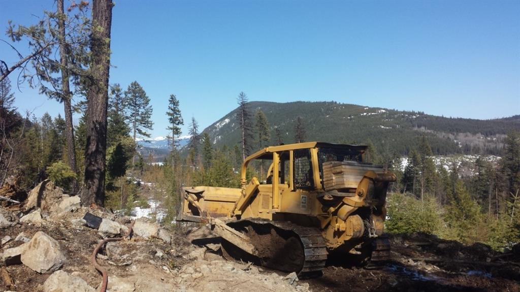
Discovered the southern extension of the Gold Drop vein by means of mechanical trenching
Completed 30 m of trenching on the Silent Friend Vein
Completed thorough trenching program in the C.O.D North region of the property
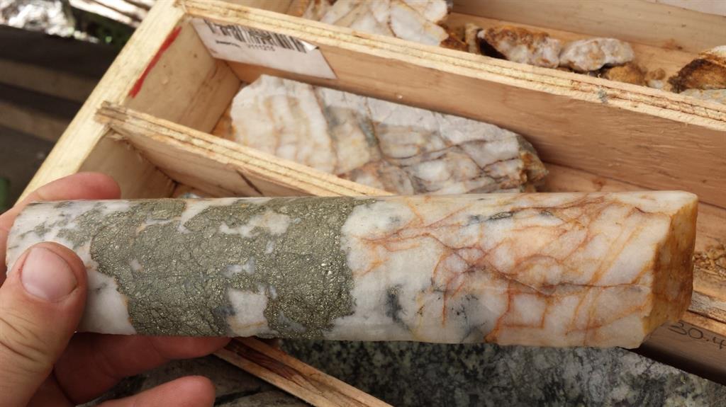
Picture: First C.O.D Vein discovery and sample, May 2017
The
Gold Drop Property covers 5,628 hectares of geologically prospective
ground in the well-mineralized Greenwood District, and hosts 8 or more
known low-sulfide, gold-bearing veins or vein systems. These historical
showings have had limited modern exploration. Recently, the Greenwood
area has had a renewed interest by major and junior companies exploring
precious and base metals in the district.
The
2018 diamond drill program carried out by the Company focused on the
C.O.D vein. The vein was first identified to be a target of interest in
the spring of 2017. Following initial sampling of the vein the Company
conducted mechanical trenching and drilling. The results of the 2017
program were encouraging and the Company launched a winter drill program
in 2018. The program followed up on the 2017 drilling. The Company
completed additional diamond drilling during the fall of 2018,
completing a series of exploration holes south of the C.O.D trench. Here
the holes intercepted the vein, successfully extending the vein by 160
meters.
During
2018 a total of 71 diamond drill holes were completed on the C.O.D vein
structure and 19 diamond drill holes were completed on the Everest vein
for a total of 5,616 meters of drilling. The highlights of the program
are COD18-67 that intersected 129 grams per tonne (g/t) gold and 1,154
g/t silver over 7.28 meters core length and COD18-70 which intersected
107.5 g/t gold and 880 g/t silver over 6.90 meters core length. The
highlights of the drilling are listed in the following table.
Hole ID
Interval Length
Gold (gpt)
Silver (gpt)
Te (gpt)
COD17-14
16.03
4.59
38.64
COD18-3
2.1
14.62
150.2
102
COD18-26
1.4
10.3
1.09
0.24
COD18-32
1.51
3.67
67.2
30.4
COD18-33
2.98
8.65
47.6
37.3
COD18-34
3.41
6.16
72.4
31
COD18-37
3.95
8.23
67.36
38.53
COD18-45
2.05
50.15
375
COD18-46
1.47
54.9
379
COD18-49
1.47
9.52
118
72.2
COD18-54
1.66
7.6
60.2
34.1
COD18-61
1.38
5.29
32.4
31.4
COD18-63
1.17
28
424.7
150.4
COD18-67
7.28
129.11
1,154.90
COD18-68
2.76
8.77
85.4
56.3
COD18-69
7.46
5.76
67.9
61.2
COD18-70
6.9
107.5
880
Note:
Due to some tellurium drill core analyses being greater than the upper
analytical limit of 500 g/t the weighted average value for tellurium
could not be calculated for some intervals.
The
2018 trenching program was completed on targets located during the 2017
soil geochemical sampling program. The most significant discovery
during the trenching is the southern extension of the historic Gold Drop
Vein. Historic production from the Gold Drop Vein System is reported to
be 335 tonnes mined during 1926-1988 (mainly during 1933-1941) with
5,020 grams of gold (14.99 g/t gold) and 35,894 grams of silver (107.1
g/t silver) recovered. Grab samples collected from this vein during 2018
assayed up to 3.37 g/t gold and 43.9 g/t silver.
The
company completed a thorough trenching program in the C.O.D North area.
This area is located approximately 600m to the north of the C.O.D
drilling worksite. Here the company conducted trenching on targets
identified during the 2017 soil geochemical sampling program.
Several
quartz vein outcroppings were located and sampled in the trenches. The
highlights include grab sample 112753 of rusty quartz vein that assayed
15.45 g/t gold, 159 g/t silver and 114.5 g/t tellurium; and sample
112759, a chip sample across a 40 centimeter wide northeast-southwest
striking sub-vertical quartz vein, that assayed 21.7 g/t gold, 216 g/t
silver and 149 g/t tellurium. The table below outlines the chip sample
assays obtained.
Sample ID
Sample type
Au (ppm)
Ag (ppm)
Te (ppm)
112751
30 cm chip
1.43
12.8
10.2
112752
40 cm chip
4.26
26.8
18.25
112753
Area grab
15.45
159
114.5
112754
Area grab
1.38
9.23
5.98
112755
Area grab
6.52
17.65
14.25
112756
30 cm chip
5.07
39.5
29.2
112757
30 cm chip
1.38
10.1
6.27
112758
Area grab
4.75
20.9
12.65
112759
40 cm chip
21.7
216
149
112761
Area grab
1.58
11.85
9.08
The
Company is very pleased with the results obtained during the 2018
season. Plans are being finalized for 2019 and everyone at GGX is
excited for the 2019 field season!
David Martin, P.Geo., a
Qualified Person as defined by NI 43-101, is responsible for the
technical information contained in this News Release.
To view the Original News release with pictures please go to the website or contact the company.
Posted by AGORACOM-JC
at 11:17 AM on Tuesday, February 12th, 2019
Investment Highlights
Kenbridge property has a measured and indicated resource of 7.14 million tonnes at 0.62% nickel, 0.33% copper
17.5 (21.8 fully diluted) percent equity stake in Eloro Resources and 2 percent NSR in their La Victoria property
Kenbridge Ni Project (ON, Canada)
Advanced stage deposit remains open in three directions, is
equipped with a 623m deep shaft and has never been mined.
Preliminary Economic Assessment completed and updated returned robust project economics and operating costs including a NPV of C$253M and cash costs of US$3.47/lb of nickel net of copper credits.
Plans for Kenbridge include updating PEA,
advancing the project through to feasibility and exploring the open
mineralization at depth
FULL DISCLOSURE: Tartisan Nickel Corp. is an advertising client of AGORA Internet Relations Corp.
Posted by AGORACOM
at 9:23 AM on Wednesday, January 9th, 2019
Results for holes COD18-61 to COD18-64 completed during the 2018 November diamond drilling program at its Gold Drop Property
COD18-45: 50.1 g/t gold and 375 g/t silver over 2.05 meters.
COD18-46: 54.9 g/t gold and 379 g/t silver over 1.47 meters.
VANCOUVER, BC / ACCESSWIRE / January 9, 2019 / GGX Gold Corp. (TSX-V: GGX), (OTCQB: GGXXF), (FRA: 3SR2) (the “Company” or “GGX“)
is pleased to announce it has received drill core analytical results
for drill holes COD18-61 to COD18-64 completed during the 2018 November
diamond drilling program at its Gold Drop Property near Greenwood,
southern British Columbia. The drilling program that was completed at
the end of November last year consisted of 11 drill holes (COD18-61 to
COD18-71) targeting the gold bearing COD vein, the focus being an area
of previous high grade gold drill intercepts. Highlights from 2018
drilling at the COD vein and the Gold Drop Property include:
COD18-45: 50.1 g/t gold and 375 g/t silver over 2.05 meters.
COD18-46: 54.9 g/t gold and 379 g/t silver over 1.47 meters.
COD18-63: 28.0 g/t gold and 424 g/t silver over 1.17 meter core length.
Gold
and silver bearing quartz veins in multiple regions of the property
with high grade gold reported (samples exceeding 1 oz. / ton gold
reported).
Historic gold and silver production at the Gold Drop, North Star, Amandy and Roderick Dhu vein systems.
The
2018 Fall diamond drilling program tested the COD vein, located in the
Gold Drop Southwest Zone. The program followed up on results from
earlier 2018 diamond drilling at the southern extension of the COD vein.
Two earlier 2018 holes at the southern extension, COD18-45 and COD18-46
(which were drilled at 45 and 50 degree dips to the west from the same
site), intersected high grade gold and silver plus significant amounts
of tellurium. COD18-45 intersected of 50.1 grams per tonne (g/t) gold
and 375 g/t silver over 2.05 meter core length including 167.5 g/t gold,
1,370 g/t silver and >500 g/t tellurium over 0.46 meter core length
(News Release of August 15, 2018). COD18-46 intersected 54.9 g/t gold
and 379 g/t silver over a 1.47 meter core length, including 223 g/t
gold, 1,535 g/t silver and greater than 500 g/t tellurium over a 0.30
meter core length (News Release of August 22, 2018).
Intersections
exceeding 1 g/t gold for drill holes COD18-61 to COD18-64 are listed in
the table below. Since true widths cannot be accurately determined from
the information available the core lengths (meters) are reported.
Hole ID
From (m)
To (m)
Length (m)
Au (g/t)
Ag (g/t)
Te (g/t)
Description
COD18-61
22.62
24.00
1.38
5.29
32.4
31.4
Quartz vein
COD18-63
23.22
24.15
0.93
2.51
19.4
12.7
Quartz veins & altered granodiorite
COD18-63
25.74
26.14
0.40
1.16
9.78
8.72
Quartz veins & altered wall rock.
COD18-63
26.14
27.31
1.17
28.0
424.7
150.4
Quartz vein with local VG & tellurides
COD18-63
incl. 26.72
27.31
0.59
49.7
787
245
Quartz vein with VG & tellurides
COD18-64
30.10
30.40
0.30
3.04
24.6
31.3
Altered granodiorite
All
of the 2018 Fall drill holes were collared within 25 meters of holes
COD18-45 and COD-46. Holes COD18-61 to COD18-66 were drilled to the west
and slightly northwest at dips of 45 to 60 degrees to intersect the
approximately northeast striking COD vein. Holes COD18-67 to COD18-71
were drilled at dips of 45 to 60 degrees slightly northeast to intersect
the COD vein at a shallower angle, the purpose being to test the
continuity of the quartz veining and mineralization. The high grade
intercept of drill hole COD18-63 is at approximate 20 meter vertical
depth (similar depth of high grade intercept of drill hole COD18-45) and
approximately 5 meters north of the high grade intercept of drill hole
COD18-45.
The COD vein system is open to the northeast and at depth and possible open to the southwest.
The
drill core was split at a secure location in Greenwood with half core
samples securely packaged and delivered to ALS Canada Ltd. in Vancouver,
BC for preparation and analysis. The core samples were analyzed for
gold by Fire Assay-AA and for 48 elements (including silver and
tellurium) by Four Acid – ICP-MS. Samples exceeding 100 g/t silver were
re-analyzed for silver by Four Acid – ICP-AES. Quality control (QC)
samples were inserted at regular intervals.
David Martin, P.Geo., a
Qualified Person as defined by NI 43-101, is responsible for the
technical information contained in this News Release.
To view the Original News release with pictures please go to the website or contact the company.
On Behalf of the Board of Directors, Barry Brown, Director 604-488-3900 [email protected]
Tags: #exploration, #GoldDrop, #GreenwoodBC, #silver, #tellerium, $GGX.ca, gold Posted in GGX Gold Corp. | Comments Off on GGX Gold Intersects 28 g/t Gold and 424 g/t Silver over 1.17 Meters Diamond Drilling Program at COD Vein on the Gold Drop Property Southern British Columbia $GGX.ca, $Tusk.ca, $GZD.ca $K.ca
Posted by AGORACOM
at 9:06 AM on Tuesday, October 30th, 2018
2017 and 2018 drill intersections (core length) of 50.1 g/t gold over 2.05 meters, 54.9 g/t gold over 1.47 meters and 4.59 g/t gold over 16.03 meters at COD Vein.
Gold and silver bearing quartz veins in multiple regions of the property with high grade gold reported (samples exceeding 1 oz. / ton gold reported).
Historic gold and silver production at the Gold Drop, North Star, Amandy and Roderick Dhu vein systems.
VANCOUVER, BC / ACCESSWIRE / October 30, 2018 / GGX Gold Corp. (TSX-v: GGX), (OTCQB: GGXXF), (FRA: 3SR2) (the “Company” or “GGX“) is pleased to announce it has commenced the fall 2018 diamond drilling program on the Gold Drop Property near Greenwood, southern British Columbia. The program will focus on the gold bearing COD Vein, located in the Gold Drop Southwest Zone. Highlights for the Gold Drop Property, including COD Vein include:
2017 and 2018 drill intersections (core length) of 50.1 g/t gold over 2.05 meters, 54.9 g/t gold over 1.47 meters and 4.59 g/t gold over 16.03 meters at COD Vein.
Gold and silver bearing quartz veins in multiple regions of the property with high grade gold reported (samples exceeding 1 oz. / ton gold reported).
Historic gold and silver production at the Gold Drop, North Star, Amandy and Roderick Dhu vein systems.
The objective of the diamond drilling program is to follow up on the high grade intersections in the COD Vein system, specifically in the area of earlier 2018 drill holes COD18-45 and COD18-46. Hole COD18-45 intersected of 50.1 grams per tonne (g/t) gold and 375 g/t silver over 2.05 meter core length, including 167.5 g/t gold, 1,370 g/t silver and >500 g/t tellurium over 0.46 meter core length (News Release of August 15, 2018) . COD18-46 intersected 54.9 g/t gold and 379 g/t silver over a 1.47 meter core length, including 223 g/t gold, 1,535 g/t silver and greater than 500 g/t tellurium over a 0.30 meter core length (News Release of August 22, 2018).
The current drill program will test the continuation of gold mineralization at depth below the intersections of drill holes COD18-45 and COD18-46 and to the south of these holes.
Gold bearing quartz vein with high grade gold in drill hole COD18-45
(50.1 g/t gold over 2.05meters)
Both COD18-45 and COD18-46 are approximately 160 meters southwest of the area of 2017 trenching at the COD Vein and approximately 220 meters southwest of drill hole COD17-14 which intersected 4.59 g/t gold over 16.03 meter core length, including 10.96 g/t gold over 5.97 meter core length (News Release of September 7, 2017).
David Martin, P.Geo., a Qualified Person as defined by NI 43-101, is responsible for the technical information contained in this News Release.
To view the Original News release with pictures please go to the website or contact the company.
On Behalf of the Board of Directors,
Barry Brown, Director
604-488-3900 [email protected]
Posted by AGORACOM
at 8:49 AM on Tuesday, September 25th, 2018
Historical work at Kagoot Brook has delineated two drainages, two kilometres apart, that exhibit remarkably high cobalt values up to 6,000 ppm in the silts
Recent silt sampling results has fully corroborated the existence and intensity of the cobalt mineralization
Significant occurrence of manganese and base metals (nickel, copper, lead and zinc) with the cobalt mineralization.
Vancouver, British Columbia (FSCwire) – GREAT ATLANTIC RESOURCES CORP. (TSX.V: GR) (the “Company†or “Great Atlanticâ€) is pleased to provide this update in regard to its Kagoot Brook Cobalt project.
To view the graphic in its original size, please click here
Kagoot Brook Co-Mn-Base Metal Project, New Brunswick Historical work at Kagoot Brook has delineated two drainages, two kilometres apart, that exhibit remarkably high cobalt values up to 6,000 ppm in the silts (see Company news releases dated May 31 and February 14, 2018). Â The recent results from a complementary silt sampling program has:
1)Â Â Â Â Â Â Â Â Â Â Â Fully corroborated the existence and intensity of the cobalt mineralization; and
2)Â Â Â Â Â Â Â Â Â Â Â Revealed a strong relationship and significant occurrence of manganese and base metals (nickel, copper, lead and zinc) with the cobalt mineralization.
The observed suite of elements and local geological units supports a ferromanganese marine environment indicating a strong affinity and trap for cobalt and base metals; a setting similar to the well-known ferromanganese stratiform mineralizing models around the world.
Of note:
1. The amount of manganese and iron in the cobalt enriched silts, upwards to 4.1% and 26.7% respectively, indicates a prevalent source with size potential; and
2. The relative percentage of the manganese to cobalt indicates a favourable high cobalt tenor (i.e. grade component).
As a result, Great Atlantic’s optionee has initiated a follow-up stream silt sampling program with tightly spaced sample stations to better frame the contact of the underlying target mineralized horizon.  In conjunction, a detailed magnetometer and very low frequency electromagnetic (“VLF-EMâ€) survey has been initiated to map the underlying stratigraphy to assist with the targeting.
Once these additional surveys have been completed and integrated with the historical work, a drill program is planned.
No drilling has ever been conducted and no source of the historic geochemical anomalies is known on the property.
Note(*): The surface rock grab and stream silt samples reported in this release are solely designed to show the presence or absence of mineralization and to characterize the mineralization. Â Grab and silt samples are by definition selective and not intended to provide nor should be construed as a representative indication of grade or mineralization at the projects.
Option Agreement
The Kagoot Brook property is 100% owned by Great Atlantic and is subject to an underlying agreement with a Explorex Resources Inc. ( EX.v ). Â Explorex is acquiring up to a 75% interest in the project. (See News Release dated February 14,2018)
Technical Information in this news release has been reviewed by David Martin, P Geo., a Qualified Person as that term is defined in NI 43-101.
On Behalf of the board of director
“Christopher R Andersonâ€
Mr. Christopher R. Anderson ” Always be positive, strive for solutions, and never give up ”
About Great Atlantic Resources Corp.: Great Atlantic Resources Corp. is a Canadian exploration company focused on the discovery and development of mineral assets in the resource-rich and sovereign risk-free realm of Atlantic Canada, one of the number one mining regions of the world. Great Atlantic is currently surging forward building the company utilizing a Project Generation model, with a special focus on the most critical elements on the planet that are prominent in Atlantic Canada, Antimony, Cobalt, Zinc, Tungsten and Gold.