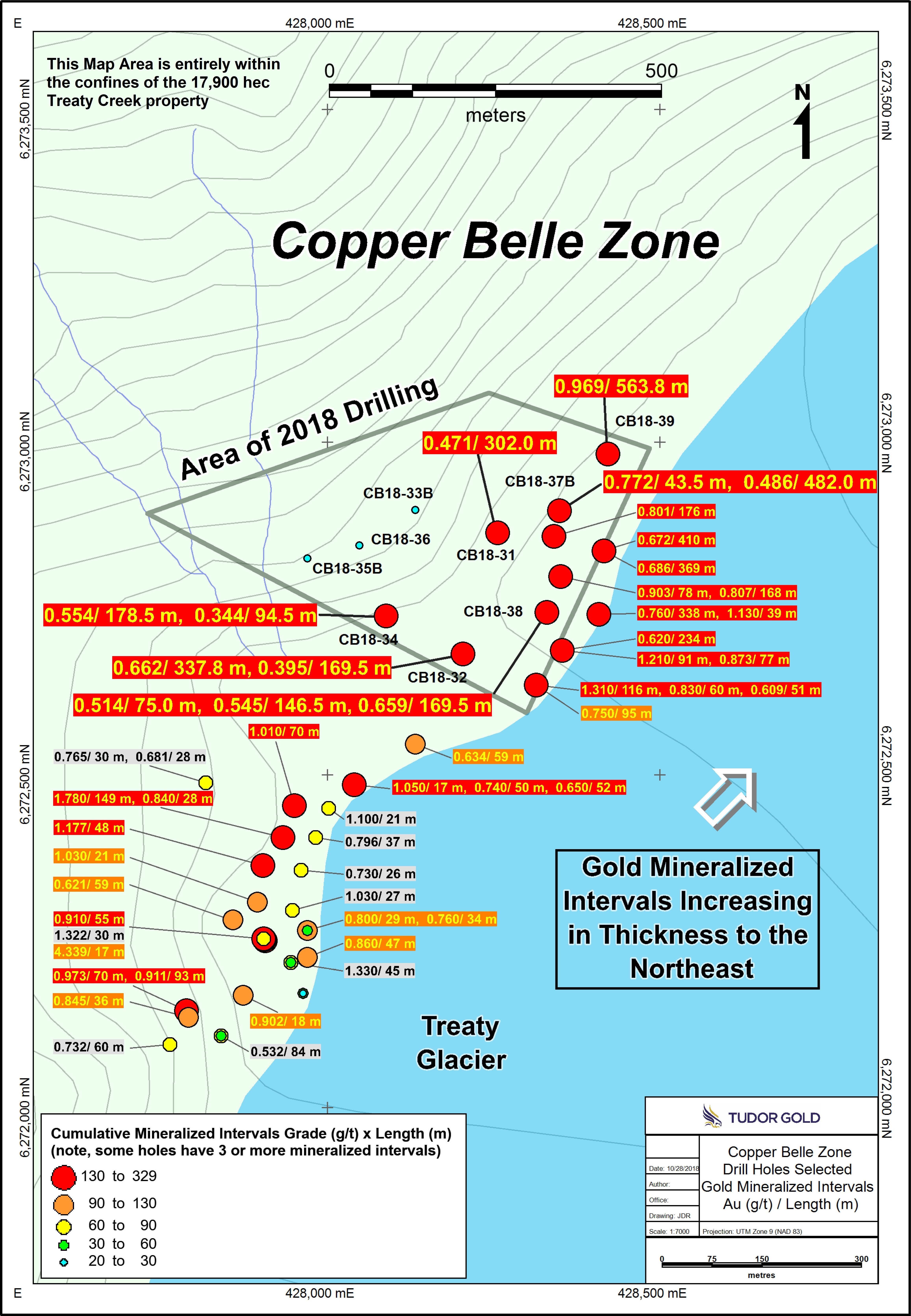
- JV partner Tudor Gold has updated information from the southern part of the Goldstorm Zone on the Treaty Creek property in the Golden Triangle
- Significant horizons of stronger gold mineralization occur in a thick envelope of low-grade gold mineralization throughout the entire Goldstorm Zone.
- Within the low-grade mineralized body, near-surface horizons of stronger gold grades occur.
- CB-17-24 interval averages 0.945 g/t Au over 213.0 meters,including the core of the zone that averages 1.925 g/t Au over a 60 meter interval.
Cardston, Alberta–(Newsfile Corp. – February 27, 2019) – American Creek Resources Ltd. (TSXV: AMK) (the “Company”)is
pleased to announce that JV partner Tudor Gold has updated information
from the southern part of the Goldstorm Zone on the Treaty Creek
property in the Golden Triangle region of British Columbia. New
composites from drill holes completed during 2017 and 2018 demonstrate
that significant horizons of stronger gold mineralization occur in a
thick envelope of low-grade gold mineralization throughout the entire
Goldstorm Zone.
Within
the low-grade mineralized body, near-surface horizons of stronger gold
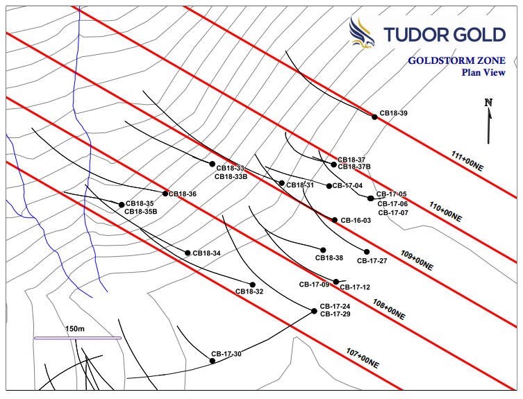
grades occur. The southernmost drill section, 107+00 NE (attached below)
demonstrates that the Goldstorm Zone contains a higher grade gold
interval at its eastern near-surface projection in hole CB-17-24. This
enriched gold interval averages 0.945 g/t Au over 213.0 metersincluding the core of the zone that averages 1.925 g/t Au over a 60 meter interval.
Similarly, the upper part of the gold intercepts in holes CB18-32 and
CB18-34 also demonstrate that the stronger gold mineralization occurs in
the upper portion of each intercept. The following table gives gold
composites from the three drill holes on Section 107+00 NE that cut the
Goldstorm Zone.

To view an enhanced version of this graphic, please visit:
https://orders.newsfilecorp.com/files/682/43074_39f1da8cb467c8d9_001full.jpgTudor
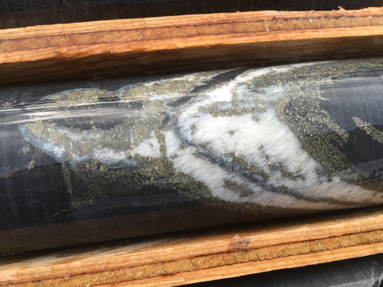
Gold Exploration Manager Ken Konkin stated: “We consistently see thick,
low-grade gold intercepts that contain distinct horizons of stronger
gold mineralization throughout the entire Goldstorm Zone. Our
preliminary petrographic studies confirm that gold mineralization is
associated with multiple pulses of disseminated and veinlet pyrite
emplacement. These events were then over-printed and mineralized by
late-stage, steep-angled, quartz-calcite-pyrite veinlets that contain
native gold. The hanging wall of the Goldstorm Zone is well defined by a
sharp fault contact. This appears to be a moderately dipping regional
thrust fault similar to the orientation and nature of the Sulphurets
Thrust Fault hanging wall contact at Seabridge’s Iron Cap deposit,
located five kilometers to the southwest.”
Goldstorm
extends for at least 500 meters along a northeastern strike and is open
to the east, north and down dip. A drill plan map showing the locations
of drill hole collars and section lines is included below in the
attached Section 107+00NE. Drill hole CB18-35B stopped within the fault
zone and therefore did not penetrate the gold zone. In the following
weeks, geologists will be planning an aggressive diamond drill hole
program for the 2019 exploration season in order to fast-track the
advancement of the Treaty Creek Project.
Tudor
Gold will be displaying core samples and drill sections at booth #3314
at the Prospectors and Developers Association of Canada convention in
Toronto March 3-6, 2019.
To view an enhanced version of this graphic, please visit:https://orders.newsfilecorp.com/files/682/43074_39f1da8cb467c8d9_002full.jpg

To view an enhanced version of this graphic, please visit:
https://orders.newsfilecorp.com/files/682/43074_39f1da8cb467c8d9_003full.jpgQA/QCIn
2016 and 2017, drill core samples were prepared and analyzed at
Activation Laboratories Ltd. in Kamloops, BC. In 2018, drill core
samples were prepared ALS Global’s Preparation Laboratory in Terrace, BC
and assayed at ALS Global’s Geochemical Laboratory in North Vancouver,
BC. Analytical accuracy and precision are monitored by the submission of
blanks, certified standards and duplicate samples inserted at regular
intervals into the sample stream by Tudor Gold personnel. Activation
Laboratories and ALS Global Laboratories quality systems comply with the
requirements for the International Standards ISO 17025: 2005.
QP
The
Qualified Person for this new release for the purposes of National
Instrument 43-101 is Tudor Gold’s Exploration Manager, Ken Konkin,
P.Geo. He has read and approved the scientific and technical information
that forms the basis for the disclosure contained in this news release.
About American Creek
American Creek holds a strong portfolio of gold and silver properties in British Columbia. Three of those properties are located in the prolific “Golden Triangle”; the Treaty Creek and Electrum joint venture projects with Tudor Gold (Walter Storm) as well as the 100% owned past producing Dunwell Mine.
The Corporation also holds the Gold Hill, Austruck-Bonanza, Ample Goldmax, Silver Side, and Glitter King properties located in other prospective areas of the province.
For further information please contact Kelvin Burton at: Phone: 403 752-4040 or Email: [email protected]. Information relating to the Corporation is available on its website at www.americancreek.comNeither
TSX Venture Exchange nor its Regulation Services Provider (as that term
is defined in the policies of the TSX Venture Exchange) accepts
responsibility for the adequacy or accuracy of this release.
Cautionary Statements regarding Forward-Looking Information
Certain
statements contained in this press release constitute forward-looking
information. These statements relate to future events or future
performance. The use of any of the words “could”, “intend”, “expect”,
“believe”, “will”, “projected”, “estimated” and similar expressions and
statements relating to matters that are not historical facts are
intended to identify forward-looking information and are based on the
Company’s current belief or assumptions as to the outcome and timing of
such future events. Actual future results may differ materially.
All
statements including, without limitation, statements relating to the
Goldstorm Zone as well as any other future plans, objectives or
expectations of the Company are forward-looking statements that involve
various risks and uncertainties. There can be no assurance that such
statements will prove to be accurate and actual results and future
events could differ materially from those anticipated in such
statements. Important factors that could cause actual results to differ
materially from the Company’s plans or expectations include risks
relating to the actual results of current exploration activities,
fluctuating gold prices, possibility of equipment breakdowns and delays,
exploration cost overruns, availability of capital and financing,
general economic, market or business conditions, regulatory changes,
timeliness of government or regulatory approvals and other risks
detailed herein and from time to time in the filings made by the Company
with securities regulators. The Company expressly disclaims any
intention or obligation to update or revise any forward-looking
statements whether as a result of new information, future events or
otherwise except as otherwise required by applicable securities
legislation.


 Â Â