Agoracom Blog Home

Posts Tagged ‘#Discovery’

American Creek $AMK.ca What Do Gretzky, Silver, and Treaty Creek Have To Do With Each Other and Why Is It Important? Doug Casey and Eric Sprott Explain $TUD.ca $SII.ca $GTT.ca $AFF.ca $SEA.ca $SA $PVG.ca $AOT.ca $ESK.ca

Posted by AGORACOM at 9:21 AM on Monday, August 31st, 2020

This week Rick Rule and Doug Casey had an excellent 2 part interview on Kitco. It was both highly informative and entertaining. I suggest that everyone watch it after you listen to Eric Sprott so I’ve included the Kitco links below for you. In the interview Doug Casey suggests that we all try to follow the advice of Wayne Gretzky which is this “On the ice skating arena, most guys skate to the puck, and that’s a problem because there’s all these big mean guys swinging sticks….skate to where you think the puck is going to be opposed to where all these big means guys swinging sticks are”.

Who can argue with Gretzky given his track record? That’s exactly what Eric Sprott is doing with his investments. He closely follows the silver / gold ratio which is 17.5:1 in the ground. As you can see on the 10 year chart below the market ratio has had dramatic increases over the last decade, and industry experts are saying it is due to silver being more manipulated than gold. In April of this year it reached a peak of 114.77 (a 94 year high) and (for various reasons) is on its way back down.

Sprott has stated that all the data “is screaming” that the market silver / gold ratio will go down to a 15:1 ratio (for many reasons but one is that the silver / gold ratio in production is only 8:1 so there just isn’t enough silver out there to account for all the silver accounts on paper and people are starting to want delivery – a very wise decision).  So like Gretzky, Sprott is looking at where the puck is going to be, or in this case where silver is going to be, and evaluating companies based on where they would be if a 15:1 ratio were to take place.
 
I thought he would start talking about the many high-grade projects out there but instead the very first example he had was Treaty Creek where the silver is just an afterthought!  The first 12 minutes is spent discussing arguments for silver and then Eric explains why Treaty is the first one he mentions would benefit from a dropping silver / gold ratio (11:40 – 13:19).  

As promised, here is the two part interview with Rick Rule and Doug Casey.  I highly suggest you watch it to the end!

SOURCE: American Creek Resources

Client Feature: Tajiri Resources $TAJ.ca Embarks on Maiden Drill Program At Rio Project, Burkina Faso $GXS.ca $EDV.ca $IMG.ca $GUY.ca

Posted by AGORACOM at 9:23 AM on Friday, August 21st, 2020

Reo Gold Project in Burkina Faso is one of 2 Company making gold projects it its property portfolio.  

Maiden Drill Program Initiated: 

  • Drilling contractor hired to conduct up to 7000m of reverse circulation drilling.  
  • Drilling is expected to start within the next 2 weeks. 

Project Focus: Morley and K4-K5 Prospects  

Morley: Prior operator identified a potential high-grade gold bearing structure of 3-10m width and 400 metres in strike. 

Previous drill and trench exploration identified high grade gold; 

  • KRAC11 32m @ 17.5g/t from 2m,  
  • MRTR001(trench) 11m @ 7.97g/t,  
  • MRRC005 10m @ 9.63g/t from 74m,  
  • MRRC040 5m @ 16.9g/t from 33m 
  • KRC022 10m @7.55g/t from 16m 

There are clear signs of potential for a high grade near surface orebody similar in nature to other mines in the region. 

K4-K5: A large gold bearing system 4 x 5 km in size with 30,000m of previous drill data guiding current exploration. 

Targeting 20 new zones for exploration follow up that correlate with the following past results  

  • MRRC0047  13m @ 2.47g/t from  
  • MRRB1608  12m @ 3.23 from 4m 
  • MRRC0081  16m @ 1.95g/t from 7m, 
    • 6m @ 2.27g/t from 54m,  
    • 13m @ 2.19g/t from 85m 
  • MRRC0091  10m @ 3.47g/t from 25m 

Additionally, Tajiri will also test another 3-6 highly prospective targets with 1,500-2,000m of further drilling. 

FULL DISCLOSURE: Tajiri Resources is an advertising client of AGORA Internet Relations Corp.

Tajiri Resources $TAJ.ca to Begin Drilling at the 100% Owned Reo Gold Project, Burkina Faso $GXS.ca $EDV.ca $IMG.ca

Posted by AGORACOM at 3:28 PM on Thursday, August 20th, 2020

Past Drill Highlights:

  • KRAC11 32m @ 17.5g/t from 2m,
  • MRTR001(trench) 11m @ 7.97g/t,
  • MRRC005 10m @ 9.63g/t from 74m,
  • MRRC040 5m @ 16.9g/t from 33m
  • KRC022 10m @7.55g/t from 16m

VANCOUVER, BC, Aug. 20, 2020 /CNW/ – Tajiri Resources Corp. (the “Company”) (TSX VENTURE: TAJ) is pleased to announce that it has entered into an agreement with Sahara Natural Resources (or “Sahara’) to provide full support to the Company’s maiden exploration program on the Reo Gold Project located some 130km west of the country’s capital Ouagadougou in Burkina Faso.  Sahara is a full-service natural resource contractor and has been providing services globally since 2010. Sahara is accredited with all major stock exchanges.  The contract envisages 4,000- 7,000m of RC drilling and 1,500- 2,500m of diamond core drilling with all work to be conducted by and supervised by Sahara.   Drilling is expected to start within the next 2 weeks.

The specific focus of the drill campaign will be at the advanced Morley and K4-K5 prospects with drilling commencing at Morley, where the previous project owner Middle Island Resources identified through drilling and trenching a potential high grade gold bearing structure of 3-10m width and 400 metres in strike, The true extent of which remains unknown.  The perspectivity of Morley is clearly demonstrated by numerous drill and trench intersections such as:

  • KRAC11 32m @ 17.5g/t from 2m,
  • MRTR001(trench) 11m @ 7.97g/t,
  • MRRC005 10m @ 9.63g/t from 74m,
  • MRRC040 5m @ 16.9g/t from 33m
  • KRC022 10m @7.55g/t from 16m

A minimum of 2,000m of RC drilling is scheduled for Morley with the objective of infilling gaps in previous drilling to demonstrating down continuity and extending the zone along strike.  With an extensive collection of historical data to provide a blueprint the Company plans to both confirm and expand on the Morley prospect area in the upcoming program, as there are clear signs of potential for a high grade near surface orebody similar in nature to other mines in the region.

After drilling Morley additional work is planned to continue, without pause, at the K4/K5 prospect, where previous scout drilling of approximately 30,000 metres of various methods has identified a large gold bearing system that to date has been defined to be some 4 x 5 km in size.  In addition, in 2013 an IP survey was conducted which identified >20 discrete chargeability + resistivity anomalies which correlate with drill intersected mineralisation such as:

  • MRRC0047  13m @ 2.47g/t from
  • MRRB1608  12m @ 3.23 from 4m
  • MRRC0081  16m @ 1.95g/t from 7m,
    • 6m @ 2.27g/t from 54m,
    • 13m @ 2.19g/t from 85m
  • MRRC0091  10m @ 3.47g/t from 25m

The planned drill program will include 2,000-4,000m of shallow RC drilling to extend strike from historic drill intersections along the chargeability + resistivity anomalies.  Drilling will be on 50-100m strep outs and will test 2-3 of the chargeability + resistivity anomalies as proof of concept before the Company embarks on a resource drilling campaign.

In addition the Company will also test 3-6 deep, highly prospective, resistivity/chargeability IP targets with 1,500-2,000m of diamond core drilling to a depth of ~400m.  IP surveys have indicated the presence of 6 targets at depths of between 250m-400m below surface that are 2-4 times the intensity of shallower targets and appear 30-50m in width. To date drilling at K4-K5 has been generally shallow with only 5 diamond drill holes ranging from 71-190m depth having been completed.  As only one of these drill holes came close to testing a deeper IP target-  MRDD 003 drilled – to a depth of 170m – which intersected at the bottom of the hole a silica-chlorite altered granodiorite which returned 2m @ 16.8g/t between 158 and 160 metres.  MRDD 003 was drilled in a down dip direction, did not test the most prospective part of the resistivity/chargeability target, and therefore the possibility that a deeper a higher grade mineralisation is related to the highly altered subsurface intrusion and as such presents an exploration target of the highest priority.

On Behalf of the Board,

Tajiri Resources Corp.

Graham Keevil,
President, CEO

American Creek $AMK.ca Begins High-Resolution Magnetic and Lidar Surveys at Past Producing Dunwell Mine Property in Golden Triangle of BC $TUD.ca $SII.ca $GTT.ca $AFF.ca $SEA.ca $SA $PVG.ca $AOT.ca $ESK.ca

Posted by AGORACOM at 9:15 AM on Thursday, August 20th, 2020
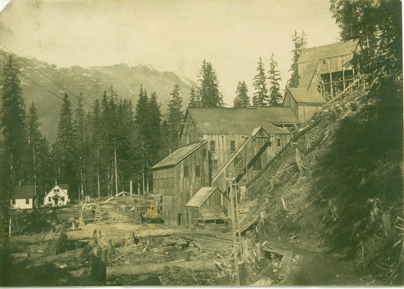
  • Dunwell Mine is one of dozens of high-grade gold / silver / lead / zinc occurrences that are primarily associated with the Portland Canal Fissure zone that extends for several kilometers through the property.

Cardston, Alberta–(Newsfile Corp. – August 20, 2020) – American Creek Resources Ltd. (TSXV: AMK) (“the Corporation”) is pleased to report that it has commenced a high-resolution magnetic survey in combination with a LIDAR survey at the company’s 100% owned Dunwell Mine gold and silver property located in the Golden Triangle of British Columbia.

Genesis Aviation Inc. is currently completing a High- Resolution Gradient Magnetometer survey in conjunction with a Three-Dimensional LIDAR survey over the property. This type of magnetic survey is flown by a low altitude helicopter and offers Measured Horizontal and Vertical Gradient data. This makes a significant difference to the magnetic inversion that provides a model at depth. The LIDAR survey being collected over the whole property will allow the past, present and future geological and geophysical programs to be correlated with a much higher degree of accuracy than otherwise possible.

The Dunwell Mine is a high-grade past producing polymetallic mine located just 8 kilometers by road from the shipping town of Stewart BC. The mine itself is one of dozens of high-grade gold / silver / lead / zinc occurrences that are primarily associated with the Portland Canal Fissure zone that extends for several kilometers through the property. The Dunwell Mine project boasts exceptional logistics and a rich mining history with potential for future development. It is located within the Bear River valley which was one of the first areas prospected in the Stewart camp because of its combination of rich veins and easy access due to the low elevation and proximity to town.

Figure 1: Image of the historic Dunwell Mine which shut down during World War II

To view an enhanced version of Figure 1, please visit:
https://orders.newsfilecorp.com/files/682/62173_9df8bb2544ec9bf6_001full.jpg

Because of the property’s low elevation and heavy rainfall, it is completely covered with a heavy canopy of vegetation with limited exposed bedrock in gullies and stream beds. As no modern exploration techniques or technologies had been conducted on the Dunwell prior to American Creek’s acquisition, careful consideration was given as to the best options that could lead to discovery. This resulted in a decision to proceed with a detailed Magnetic survey in 2020 and an Induced Polarization (IP) survey in the fall of 2019.

Alpha IP was chosen over a conventional IP survey because of its cutting-edge technology in detecting detailed high chargeability / low resistance anomalies in the ground. Specifically, the Alpha IP survey has far greater resolution and depth than standard IP’s and can provide the data in a 3D view. These are critical factors as the Dunwell Mine property contains numerous high-grade veins that are more readily detected using a high-resolution survey. Simcoe Geoscience, who performed the survey, was chosen because of their exceptional experience in this field and the in-depth interpretation they provide. They will also be using their expertise to integrate the new 3D Magnetic Survey results with the existing IP results. Simcoe’s same Alpha IP system continues to achieve success locating high-grade veins at Ascot’s neighboring Silbak-Premier Mine (9km away).

The exploration objectives of the Alpha IP survey were to detect the source of potential high‐grade Au, Ag, Pb, Zn, Cu in quartz and detect quartz breccia veins hosted in thin bedded argillite, siltstone and greywacke of the Middle Jurassic Salmon River Formation (Hazelton Group). The Alpha IP system was used to provide the following benefits:

  • Detect and delineate zones and structures related to the emplacement of sulphide mineralization to depths of up to 400 meters with chargeability and resistivity.
  • Mapping the resistivity and chargeability features related to mineralization, alteration, faults and lithologies.

Thirty-seven anomalous zones were interpreted as significant targets for follow up from surface to ~300m+ depth. Out of thirty-seven anomalous zones, fifteen are considered first priority, sixteen second and six are third priority targets. The anomalous zones consist of strong to moderate chargeability related to associated conductive to resistive zones. These targets have a strong correlation with the Portland Canal Fissure Zone with the strongest targets running along the Dunwell Creek / Portland Canal Fault, the secondary targets running down each side of the primary target, and the tertiary targets running along the western edge of the fissure zone.

CEO and President, Darren Blaney stated: “We are excited about the magnetic and Lidar surveys taking place right now and the further detail they will give us in expanding our understanding of the underground geology when combined with last fall’s Alpha IP.

“We have always thought that the numerous high-grade gold and silver showings associated with the Portland Canal Fissure Zone, that extends for several kilometers down the valley, are related in some meaningful way and may be part of the same geological event. The additional geophysics will greatly add to our understanding of the geology down to 400 meters in depth.

“We are expecting quick turnaround of the new geophysics data which will allow us to commence the Phase II drill program this fall with the advantage and added benefit of utilizing this new information in targeting the drill.”

Property Description and History

The property is located just 7 km east of the Silbak Premier Mine (Ascot Resources), 11 km west of the Red Mountain deposit (Ascot – formally IDM), and only 9 km north of the past producing Porter Idaho silver mine (Strikepoint Gold). Through a series of strategic acquisitions American Creek was able to purchase the past-producing Dunwell Mine as well as several adjoining very prospective properties, combining them into one large land package that encompasses the most promising gold and silver mineral occurrences and historic workings within the Bear River valley. The amalgamated property spans 2,222 hectares covering the majority of the Portland Canal Fissure Zone, an area first prospected in the late 1800’s and hosting some of the earliest producing gold and silver mines in the Stewart area.

Figure 2: Image of the Dunwell Mine Property located between Ascot’s Premier Mine and Red Mountain

To view an enhanced version of Figure 2, please visit:
https://orders.newsfilecorp.com/files/682/62173_9df8bb2544ec9bf6_002full.jpg

The Portland Canal Fissure Zone is the most significant geological feature in the Bear River valley. This zone of faulting and shearing trends north, dips steeply west and hosts a vein system that extends southward for 6.5 kilometres from the Victoria/Dandy occurrence (on Dunwell) in the north, through the Dunwell mine itself, across Glacier Creek to the Ben Bolt occurrence (on Dunwell) in the south. With the recent acquisition of the Glacier Creek Crown Grants (south of Glacier Creek) American Creek now controls 5km of the 6.5km fissure zone which contains numerous high-grade polymetallic mineral occurrences including two past producing mines (Dunwell and Portland Canal).

The Dunwell project is located 8km northeast of Stewart and is road accessible with the Dunwell Mine adit itself located only 2km from Highway 37A and a major power line (both running through the property). Stewart hosts two deep sea ports including ore loading and shipping facilities. Unlike the majority of mineral properties located near Stewart, the Dunwell Mine is located in low mountainous terrain (800 m and lower elevation) with relatively moderate relief. These features allow for potential year-round work which typically isn’t the case for exploration programs conducted in the Stewart region where projects are typically at higher altitude, are accessible only by helicopter, and lack critical infrastructure such as roads and power. The Dunwell Mine project may very well have the best logistics of any project within the Golden Triangle.


Figure 3: Image of the Dunwell Mine boundary and showings

To view an enhanced version of Figure 3, please visit:
https://orders.newsfilecorp.com/files/682/62173_9df8bb2544ec9bf6_003full.jpg

The Dunwell Mine is the most significant mineral occurrence within the Portland Canal Fissure Zone. Production at the Dunwell occurred between 1926 and 1941. From historic reports, it appears that a total of 45,657 tonnes averaging 6.63 g/t gold, 223.91 g/t silver, 1.83% lead, 2.43% zinc and 0.056% copper were produced.

In addition to the Dunwell mine itself, the property package also contains over two dozen other high-grade gold and silver occurrences and historic small-scale gold/silver high-grading operations along a north/south trend that correlates to the fissure zone and major faulting. Some examples of the nine areas that actually produced ore are:

  • Ben Ali: 4,500 tons at 21.6 g/t gold
  • Lakeview 60 tons at 4.7 g/t gold, 2,734 g/t silver, and 11.5% lead
  • Victoria 11 tons at 20.15 g/t gold, 775 g/t silver, 25% lead
  • Tyee 8.2 tons at 124.4 g/t gold and 4,478.8 g/t silver
  • George E 12 tons at 13 g/t gold and 3,250 g/t silver, 23.3% lead

Each of these areas were producing during the 1930’s when exploration techniques and technology was very primitive.

The High- Resolution Gradient Magnetometer survey combined with the 3D Alpha IP survey represent the cutting edge in geophysical technology today and are designed to aid with understanding potential correlations between the multiple high-grade surface showings.

The Dunwell Phase II drill program is expected to commence early this fall once the data and interpretation from the geophysics survey is available.

For more information on the Dunwell Mine please click here:
https://americancreek.com/index.php/projects/dunwell-mine

Qualified Person

The Qualified Person for this news release for the purposes of National Instrument 43-101 is Jim McRae, P.Geo. He has read and approved the scientific and technical information that forms the basis for the disclosure contained in this news release.

About American Creek

American Creek holds a strong portfolio of gold and silver properties in British Columbia.

The portfolio includes three Golden Triangle gold/silver properties; the Treaty Creek joint venture with Walter Storm/Tudor Gold, as well as the 100% owned D-1 McBride property and 100% owned past-producing Dunwell Mine.

Other properties held throughout BC include the Gold Hill, Austruck-Bonanza, Ample Goldmax, Silver Side, and Glitter King.

For further information please contact Kelvin Burton at: Phone: 403 752-4040 or Email: [email protected]. Information relating to the Corporation is available on its website at www.americancreek.com.

American Creek $AMK.ca Announces Significant Expansion of the D1-McBride Property in BC’s Golden Triangle $TUD.ca $SII.ca $GTT.ca $AFF.ca $SEA.ca $SA $PVG.ca $AOT.ca $ESK.ca

Posted by AGORACOM at 3:39 PM on Tuesday, August 18th, 2020
  • The D1-McBride property is located 60 km northeast of the Red Chris mine (Imperial Metals / Newcrest Mining)

Cardston, Alberta–(Newsfile Corp. – August 18, 2020) – American Creek Resources Ltd. (TSXV: AMK) (“the Corporation”) is pleased to report that it has significantly expanded its D1-McBride property located in the northeast corner of British Columbia’s Golden Triangle. The new claim block encompasses an area of approximately 2,600 hectares immediately adjacent to and surrounding the Corporation’s original 34-hectare D1-McBride property. The Corporation holds a 100% interest in the property.

The D1-McBride property is located in the Liard Mining Division, about 64 km southeast of Dease Lake and 60 km northeast of the Red Chris mine (Imperial Metals / Newcrest Mining). This area of the Stikine Mountain Range has a history of placer gold and Jade mines. It is quickly becoming a hotbed of activity as companies are starting to recognize the potential it holds.

According to BC MINFILE No 104-093, the property is host to a galena and gold bearing quartz/calcite vein system. According to Assessment Report 35096, work on the property in 2014 included limited rock sampling of a vein subcrop from the Discovery Showing which returned high grade assays of 43.1 g/t gold, 240 g/t silver, 1.8% lead and 1.98% zinc and 13.1 g/t gold, 16 g/t silver, 2.32% lead and 3.02 zinc. Previous sampling of veins returned assays of 161.32 g/t gold, 1,110.9 g/t silver, 3.17% lead and 2.1% zinc across 10 centimeters and 115.89 g/t gold, 589.72 g/t silver, 12.3% lead and 11.04 oz/t zinc across 25 centimeters (Assessment Report 14004). The vein strikes 030 degrees with a vertical dip and has been traced, through prospecting and trenching, for 30 meters on surface. The overburden-covered lineament in which the vein occurs can be traced for 300 meters (MINFILE N0 104-093).

The additional claims expand the property to cover the projected trace of the exposed veining system, the fault system believed to be related to the mineralization, and regional faults. The property now spans 2,600 hectares, making it the Corporation’s largest single property. Very limited past exploration has taken place on the property.


D1-McBride Claims

To view an enhanced version of this image, please visit:
https://orders.newsfilecorp.com/files/682/62018_americancreek1enhanced.jpg

This most recent expansion of the D1-McBride is part of the Corporation’s ongoing strategy of adding shareholder value by increasing its gold and silver property portfolio in key exploration and mining camps such as the Golden Triangle. The Golden Triangle is quickly becoming one of the world’s premiere exploration jurisdictions. While there is a strong history of mining in the northeast part of the Triangle, the vast majority of this portion of the Triangle is still relatively untouched and awaiting exploration.

Qualified Person

The Qualified Person for this news release for the purposes of National Instrument 43-101 is Jim McCrea, P.Geo. He has read and approved the scientific and technical information that forms the basis for the disclosure contained in this news release.

About American Creek

American Creek holds a strong portfolio of gold and silver properties in British Columbia.

The portfolio includes three Golden Triangle gold/silver projects; the Treaty Creek joint venture with Walter Storm/Tudor Gold, as well as the 100% owned D-1 McBride property and 100% owned past-producing Dunwell Mine.

Other properties held throughout BC include the Gold Hill, Austruck-Bonanza, Ample Goldmax, Silver Side, and Glitter King.

For further information please contact Kelvin Burton at: Phone: 403 752-4040 or Email: [email protected]. Information relating to the Corporation is available on its website at www.americancreek.com.

Affinity Metals $AFF.ca Commences Field Exploration and Drill Program on Regal Gold and Silver Project $MKR.ca $SII.ca $TUD.ca $GTT.ca $AMK.ca $OSK.ca $RKR.ca

Posted by AGORACOM at 9:08 AM on Friday, August 14th, 2020
  • Exploration program will focus on several key areas of the property and will consist of further geological mapping and associated geochemical sampling
  • 2,000 meters of diamond drilling.

Vancouver, British Columbia–(Newsfile Corp. – August 14, 2020) – Affinity Metals Corp. (TSXV:AFF)”) (“Affinity”) (“the Corporation”) is pleased to announce that it has commenced the 2020 field exploration program at its flagship Regal Project encompassing 8,800 hectares of the northern end of the prolific Kootenay Arc approximately 25 km northeast of Revelstoke, British Columbia, Canada.

The exploration program will focus on several key areas of the property and will consist of further geological mapping and associated geochemical sampling as well as up to 2,000 meters of diamond drilling. The initial program may be expanded depending on ongoing prospecting and sampling being conducted in previously unexplored areas of the property.

Allco – Silver Discovery

The drilling in the Allco area is designed to test part of a large, several kilometer long northwest-southeast fault/contact that separates limestones from argillites. Previous 2019 prospecting and surface sampling in the vicinity of several past producing historic adits resulted in the discovery of several high grade silver and gold surface outcrops. Drilling in this same area last fall resulted in a significant new silver discovery being made with drill hole #10 intersecting 11.10 meters of 143.29 g/t silver including 0.55 meters of 2612.0 g/t silver. This intersection also carried high grade zinc and lead with some copper. Mineralized intersections within the drill core consisted mostly of argentiferous galena, sphalerite and tetrahedrite hosted within quartz veins and breccias.

The Allco portion of the 2020 exploration program will focus on expanding the hole #10 silver discovery through step out drill holes and detailed surface mapping and will also attempt to test the continuity of the mineralized structure further along the fault/contact.

Z-TEM – SG3 Acoustic EM Geophysical Anomaly

Drilling is planned to test a very large geophysical anomaly defined by previously flown Z-TEM (Geotech Ltd.) as well as overlapping SG3 Acoustic EM (Earth Sciences Services Corp.). The anomaly is located between the Allco and Regal areas of the property in an area in which several major fault structures converge.

This geophysical anomaly potentially represents a significant “engine” for the regional geological system exhibiting high grade polymetallic veins and enriched silver-lead-zinc soil anomalies distributed over a several kilometer trend through the past producing Allco and Regal areas of the property.

Robert Edwards, CEO of Affinity stated: “We are excited to get back on the property to build on the successes of the past exploration with our 2019 silver discovery and also to now drill test this substantial geophysical target. The timing of this Regal program really couldn’t be better coinciding with the gold and silver markets showing incredible bullishness.”

Qualified Person

The Qualified Person for the Regal Project for the purposes of National Instrument 43-101 is Alicia Carpenter, P.Geo. She has read and approved the scientific and technical information that forms the basis for the disclosure contained in this news release.

About Affinity Metals

Affinity is focused on the acquisition, exploration and development of strategic metal deposits within North America. Affinity is following a hybrid approach of combining the advancement of strategic assets along with following a Project Generator model.

Affinity presently holds two properties in British Columbia as well as five properties located near Timmins, Ontario. Affinity is presently advancing both the Regal and West Timmins Gold projects.

The Regal is located near Revelstoke, BC in the northern end of the prolific Kootenay Arch and hosts several major geophysical anomalies as well as three historic small-scale past producing mines. Affinity conducted the first known drill program in the Allco area of the property in 2019 which resulted in a new silver discovery with an 11.10 meter interval of 143.29 g/t silver which included a 0.55 meter interval of 2,612.0 g/t silver.

The West Timmins Gold property is located near Timmins, Ontario, Canada and adjoins Melkior’s Carscallen project. The first drill hole has been completed and assays from that first hole are expected to be received by the Corporation within the next two weeks.

On behalf of the Board of Directors

Robert Edwards, CEO and Director of Affinity Metals Corp.

The Corporation can be contacted at: [email protected]

Information relating to the Corporation is available at: www.affinity-metals.com

Gold-Silver Ratio Reaches Its Highest Level In 87 Years From Its Lowest Level In 41 Years SPONSOR: Affinity Metals $AFF.ca $MKR.ca $SII.ca $TUD.ca $GTT.ca $AMK.ca $OSK.ca $RKR.ca

Posted by AGORACOM at 9:56 AM on Monday, August 10th, 2020
https://s3.amazonaws.com/s3.agoracom.com/public/companies/logos/564657/hub/Affinity_Metals_Corp_Logo.png

Affinity is focused on the acquisition, exploration and development of strategic metal deposits within North America. In addition to the West Timmins Gold project, Affinity is advancing the Regal Project in the northern end of the prolific Kootenay Arch. Regal hosts two major geophysical anomalies as well as three past producing mines. Recent drill results included a new silver discovery with an 11.10 meter interval of 143.29 g/t silver which included a 0.55 meter interval of 2,612.0 g/t silver Click Here For More Info

  • The gold-silver ratio indicates how many ounces of silver are required to buy one ounce of gold. In time periods where the ratio is relatively high, it acts as a leading indicator for a rise in silver’s value

As technical indicators go, the ratio of gold price to silver prices, commonly referred to as the gold-silver ratio, is considered by precious metal traders to be one of the most reliable indicators for forward price movements in silver.

The gold-silver ratio indicates how many ounces of silver are required to buy one ounce of gold. In time periods where the ratio is relatively high, it acts as a leading indicator for a rise in silver’s value.

Previously the highest the ratio has ever been was 132 to 1 in 1933, when the US government invoked Executive Order 6102 and forced US citizens to sell all but a small portion of their gold and silver holdings to the Federal Reserve.

In more recently the highest the ratio has reached id 97.3 to 1 in February 1991 (Figure 1), at the height of a global economic recession. After this high in the ratio, the silver price rose in a continued uptrend from an average price of US$3.74/oz in February 1991 to US$6.84/oz in February 1998, an increase of 83%.

Figure 1: Gold-Silver Ratio since 1990

Source: Mining and Metals Research Corporation Ltd.

In June 2003, after a sustained five-year period of lower gold-silver ratios, the gold-silver ratio reached a high of 78.7:1, over the next five years the silver price rose from US$4.53/oz to a high of US$19.32/oz in March 2008, (Figure 1) an increase of 326%.

A spike in the gold-silver ratio in December 2008 to 79.3:1, associated with another global recession, was a leading indicator of a 315% increase in the silver price from US$10.29/oz in December 2008 to US$42.7 in April 2011 (Figure 1).

The gold-silver ratio has now risen from a low of 34.7:1 in April 2011, its lowest level since 1979, to its highest level in 87 years of 111.7:1 in April 2020, before reducing to 90.6:1 in July on the back of a 35% rise in the silver price over just three months (Figure 1).

Could we now be facing a sustained uptrend in the silver price?

Historical precedent appears to suggests so, only once in history was silver more undervalued compared to gold than it was in April 2020 and that was in 1933 when the US Government forced its citizens to sell their precious metal holdings.

Source: https://www.proactiveinvestors.co.uk/companies/news/926237/gold-silver-ratio-reaches-its-highest-level-in-87-years-from-its-lowest-level-in-41-years-926237.html

Labrador Gold $LAB.ca Announces Start of Exploration at Kingsway $RIO.ca $WHM.ca $SIC.ca $NXS.ca $NVO.ca $CFE.ca

Posted by AGORACOM at 9:24 AM on Thursday, August 6th, 2020

TORONTO, Aug. 06, 2020 (GLOBE NEWSWIRE) — Labrador Gold Corp. (TSX-V: LAB | OTCQB: NKOSF) (“LabGold” or the “Company”) is pleased to announce that its field crew has arrived in Gander and started the 2020 exploration program on the Kingsway Property.

LabGold’s work program will initially focus on following up known gold anomalies identified from previous work on the three licenses. Soil sampling has begun on a high priority target that covers a 3km long anomaly of gold in heavy mineral concentrates with values from <5ppb to 89ppm (89g/t Au) that runs along the interpreted trace of the Appleton fault zone. Geological mapping and prospecting of anomalous areas and known showings is also underway.

Up to 10,000 soil samples and 250 km of ground magnetics/VLF-EM are planned for the property and are expected to take about six weeks to complete. We intend to hit the priority areas with known gold anomalies first so that the results of these surveys, together with the results of the geological mapping and prospecting can be used to plan a first phase fall drilling program.

Concurrently with the field work, we are working on a structural compilation of the district. This compilation will allow us to more efficiently target areas for detailed mapping and prospecting based on a better understanding of the role of primary and secondary structures on the localization of gold mineralization.

“It feels good to get boots on the ground at Kingsway which we believe to be the most strategically located property in the Gander gold district relative to New Found Gold’s recent discovery,” said Roger Moss, President and CEO. “Our focus on soil geochemistry and mag/VLF to define structures and potential alteration zones is consistent with what has worked well in the past and we expect to generate numerous targets along the major structures for drill testing.”

“It’s good to see the Kingsway Project moving along. Our limited 2019 deeper soil program over anomalous gold in till and vegetation samples proved successful in outlining new gold targets that will be followed up during this season’s work,” said Shawn Ryan, Technical Advisor to LabGold. “Based on last year’s success, the proposed larger 10,000 sample soil program covering existing gold in till and vegetation samples should produce some nice new gold anomalies leading to new drill targets.”

Roger Moss, PhD., P.Geo., is the qualified person responsible for all technical information in this release.

The Company gratefully acknowledges the Newfoundland and Labrador Ministry of Natural Resources’ Junior Exploration Assistance (JEA) Program for its financial support for exploration of the Kingsway property.

About Labrador Gold:

Labrador Gold is a Canadian based mineral exploration company focused on the acquisition and exploration of prospective gold projects in Eastern Canada.

In early March 2020, Labrador Gold acquired the option to earn a 100% interest in the Kingsway project in the Gander area of Newfoundland. The property is along strike to the northeast of New Found Gold’s discovery of 92.86 g/t Au over 19.0 metres on their Queensway property. (Note that mineralization hosted on adjacent or nearby properties is not necessarily indicative of mineralization hosted on the Company’s property). In early July 2020, the Company signed an option agreement to acquire a third license to add to the property package which now covers approximately 77 km2. The three licenses comprising the Kingsway project cover approximately 16km of the Appleton fault zone which is associated with gold occurrences in the region, including the New Found Gold discovery. Historical work over the area covered by the Kingsway licenses shows evidence of gold in till, vegetation, soil, stream sediments, lake sediments and float. Infrastructure in the area is excellent located just 18km from the town of Gander with road access to the project, nearby electricity and abundant local water.

The Hopedale property covers much of the Hunt River and Florence Lake greenstone belts that stretch over 80 km. The belts are typical of greenstone belts around the world but have been underexplored by comparison. Initial work by Labrador Gold during 2017 show gold anomalies in soils and lake sediments over a 3 kilometre section of the northern portion of the Florence Lake greenstone belt in the vicinity of the known Thurber Dog gold showing where grab samples assayed up to 7.8g/t gold. In addition, anomalous gold in soil and lake sediment samples occur over approximately 40 kilometres along the southern section of the greenstone belt (see news release dated January 25th 2018 for more details). Labrador Gold now controls approximately 57km strike length of the Florence Lake Greenstone Belt.

The Ashuanipi gold project is located just 35 km from the historical iron ore mining community of Schefferville, which is linked by rail to the port of Sept Iles, Quebec in the south. The claim blocks cover large lake sediment gold anomalies that, with the exception of local prospecting, have not seen a systematic modern day exploration program. Results of the 2017 reconnaissance exploration program following up the lake sediment anomalies show gold anomalies in soils and lake sediments over a 15 kilometre long by 2 to 6 kilometre wide north-south trend and over a 14 kilometre long by 2 to 4 kilometre wide east-west trend. The anomalies appear to be broadly associated with magnetic highs and do not show any correlation with specific rock types on a regional scale (see news release dated January 18th 2018). This suggests a possible structural control on the localization of the gold anomalies. Historical work 30 km north on the Quebec side led to gold intersections of up to 2.23 grams per tonne (g/t) Au over 19.55 metres (not true width) (Source: IOS Services Geoscientifiques, 2012, Exploration and geological reconnaissance work in the Goodwood River Area, Sheffor Project, Summer Field Season 2011). Gold in both areas appears to be associated with similar rock types.

The Company has 91,584,175 common shares issued and outstanding and trades on the TSX Venture Exchange under the symbol LAB.

For more information please contact:             

Roger Moss, President and CEO      Tel: 416-704-8291

Or visit our website at: www.labradorgold.com

Twitter:@LabGoldCorp

VIDEO – 2020 Drill Program at Treaty Creek Exceeding Expectations $AMK.ca $TUD.ca $SII.ca $GTT.ca $AFF.ca $SEA.ca $SA $PVG.ca $AOT.ca $ESK.ca

Posted by AGORACOM-JC at 5:57 PM on Thursday, July 30th, 2020

American Creek Resources Ltd. (TSXV: AMK) sits down to discuss the exceptional assay results on Treaty Creek that have already exceeded last years results resulting in en expansion to 6 drills and 40,00m. Sit down and grab your favorite beverage and find out why Eric Sprott believes Treaty creek may have 50 Million ounces. His words not ours.

“Eric Sprott has stated regarding Treaty Creek “I was just doing some numbers the morning and I figured, Man, they certainly look like they’ve got 20 (million ounces gold) and they could easily get to 30 or 40 or 50 million”

Watch this interview or listen by Podcast on AppleGoogleSpotify or your favourite podcaster.

Affinity Metals $AFF.ca Advisor Ronald Stoerfele Provides His Perspective On Gold In This New Bull Market $MKR.ca $SII.ca $TUD.ca $GTT.ca $AMK.ca $OSK.ca $RKR.ca

Posted by AGORACOM at 12:41 PM on Wednesday, July 29th, 2020
  • “Ronald Stöferle: Gold Outperforming the Equity Markets”

Interview with the author of “In Gold We Trust” and fund manager at Incrementum. Gold is in a healthy and strong bull market, fueled by the financial stimuli of governments and central banks. Ronald Stöferle has set an ambitious price target for gold at the end of the decade.