Posted by AGORACOM
at 8:46 AM on Monday, March 18th, 2019
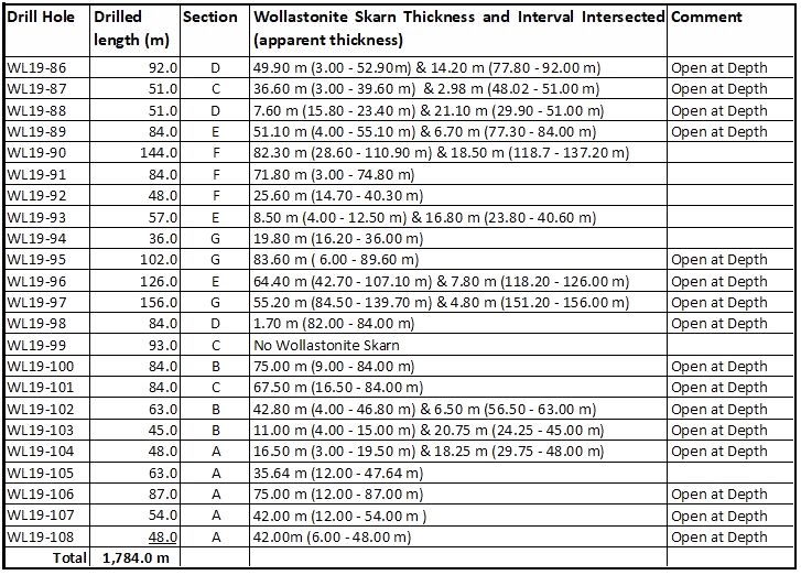
Twenty-three (23) drill holes totaling 1,784.0 metres were completed in less than two weeks of drilling (see Figure 1 & Table 1).
Twenty (20) drill holes intersected high-grade wollastonite zones, confirming excellent continuity and correlation with the thickly mineralized zones intersected by previously reported historical drill holes.
Sixteen (16) drill holes intersected high-grade wollastonite zones right up until the end of the hole, which are all open at depth.
A total of 1,107.5 meters of high-grade wollastonite mineralized core length was intersected, representing approximately 62% of all drilled core length.
VANCOUVER, BC / ACCESSWIRE / March 18, 2019 /
VERTICAL EXPLORATION INC. (TSX-V: VERT) (“Vertical” or “the Company”) is
pleased to announce that it has completed a successful diamond drilling
and sampling program on its advanced stage St-Onge-Wollastonite Deposit
located approximately 90 kilometres Northwest of the city of Saguenay,
in St-Onge township, in the Saguenay-Lac-St-Jean region of Quebec,
Canada.
The primary goal of the 2019 drilling program, which
consisted of seven (7) drilling sections (see Figure 1, Sections A-G),
was to establish an additional measured mineral resource of
approximately 5 million tonnes of crude wollastonite. The pit
constrained mineral resources at the St-Onge Wollastonite deposit, as
previously reported in the Company’s August 2, 2018 news release,
comprises an NI 43-101 compliant resources totaling 14 million tonnes at
36.61% Wollastonite in the measured and indicated class using a cut-off
grade of 30% Wollastonite (7.1 million tonnes at 36.20% in measured and
6.9 million tonnes at 37.04% in indicated), and 17.9 million tonnes at
40.25% in the inferred class (rounded numbers). The NI 43-101 Technical
Report was prepared by GoldMinds Geoservices Inc. (‘GMG’).
HIGHLIGHTS OF THE 2019 DRILLING CAMPAIGN
Twenty-three
(23) drill holes totaling 1,784.0 metres were completed in less than
two weeks of drilling (see Figure 1 & Table 1).
Twenty
(20) drill holes intersected high-grade wollastonite zones, confirming
excellent continuity and correlation with the thickly mineralized zones
intersected by previously reported historical drill holes.
Sixteen
(16) drill holes intersected high-grade wollastonite zones right up
until the end of the hole, which are all open at depth.
A
total of 1,107.5 meters of high-grade wollastonite mineralized core
length was intersected, representing approximately 62% of all drilled
core length.
In total, nine hundred thirteen (913) drill
core samples of approximately 1.5 metres in length, including samples
ranging from less than one 1.0 metre in length and up to a maximum of
2.5 metres in length, were collected for laboratory assaying. Eighty-one
(81) of the 913 drill core samples were quality assurance/quality
control (QA/QC) samples, including mineralized certified samples, blank
samples and duplicate samples.
Peter P. Swistak, President and CEO
of Vertical Exploration, commented: ”I am very pleased with the speed
of completion and overall success of this 2019 drilling program. The
mineral data obtained from the program will now allow the Company to
further update its NI 43-101 Technical Report and continue to
aggressively move forward with its plans to begin the quarry permitting
process on its St-Onge-Wollastonite Deposit.”
Complete drilling results for the 23 hole program will be announced when received.
The
diamond drilling program has been supervised by Jean-Paul Barrette P.
Geo., a qualified person under National Instrument 43-101 contracted by
Magnor Exploration Inc., and responsible for reviewing and approving the
technical contents of this press release as they pertain to the
St-Onge-Wollastonite property.
ABOUT VERTICAL EXPLORATION
Vertical
Exploration’s mission is to identify, acquire, and advance high
potential mining prospects located in North America for the benefit of
its stakeholders. The Company’s flagship St-Onge-Wollastonite property
is located in the Lac-Saint-Jean area in the Province of Quebec.
Posted by AGORACOM
at 9:02 AM on Friday, March 15th, 2019
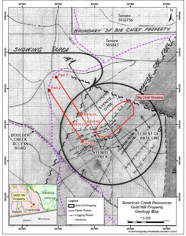
100% owned Gold Hill property located in the Boulder Creek drainage, a tributary of the Wildhorse River
4 diamond drill holes on two sections totaling 2,087 meters of drilling. Nine hundred and twenty nine (929) drill core samples
This is the first time area has been drilled. The program successfully intersected multiple zones of gold.
A high grade intersection in hole NS18-01 contained 66.4 g/t gold over 0.2 meters (true width unknown)
Cardston, Alberta–(Newsfile Corp. – March 15, 2019) – American Creek Resources Ltd.
(TSXV: AMK) (“American Creek”) is pleased to report on drilling results
from the late fall exploration program conducted on its 100% owned Gold
Hill property located in the Boulder Creek drainage, a tributary of the
Wildhorse River east of Fort Steele, British Columbia. The preliminary
program included four diamond drill holes on two sections totaling 2,087
meters of drilling. Nine hundred and twenty nine (929) drill core
samples were analyzed.
The management and professionals that
guided the exploration program are pleased and very encouraged by the
results. There were multiple gold intersections in all 4 preliminary
drill holes. A summary of the significant intersections and gold values
is contained herein.
The 2018 drill program was conducted to test
a Cretaceous age swarm of syenite porphyry dykes intruded into lower
and middle Cambrian sediments. This is the first time that this package
of rocks has ever been drilled. The drill program successfully
intersected multiple zones of gold associated with several syenite dike
targets as well as significant intervals of highly altered, silicified
rock. In addition, there were several intersections of highly altered
and, in some cases, calcareous sediments, some of which contained
elevated gold values. These altered sediments will be further explored
for gold content. They will also be useful as marker horizons guiding
future drilling.
A high grade intersection in hole NS18-01
contained 66.4 g/t gold over 0.2 meters (true width unknown). This
intersection correlates with prior historic gold values obtained in the
area. Car samples and face samples from a drift (small tunnel) driven
partially along the hanging wall of a syenite porphyry dyke in 1937 were
assayed over a width of 1.5 feet (~0.5m). The car samples averaged
0.43 oz. Au per ton (13.4 g/t), 0.48 oz. (14.9g/t) Ag per ton and 2.3%
Pb per ton over 40 feet (12.2m). The face samples along 22 feet (6.7m)
averaged at 2.4 oz. Au per ton (74.6 g/t) 2.17 oz. (67.5 g/t) Ag per
ton and 5.51% Pb.
The Gold Hill property covers approximately 836
hectares and is located along the eastern edge of the Kimberly Gold
Trend. The property is road accessible by paved highway to Fort Steele
and then by main logging roads to (and through) the property. Driving
time from Cranbrook to the center of the property is less than one hour.
The
property contains a significant portion of the Boulder Creek drainage, a
tributary of the Wild Horse River which is considered to be one of the
greatest placer gold rivers in the entire province. Gold rushes have
taken place there since the 1860’s that have yielded over 48 tonnes of
reported gold, making it Canada’s 4th largest placer producer. The
majority of the gold recovered from the Wild Horse was located along a 6
km stretch between Boulder Creek (upstream) and Brewery Creek
(downstream). From the point where Boulder Creek enters the Wild Horse
River for a distance of 6 kilometers downstream, a minimum of 1.5
million ounces (45,655,215 grams) of placer gold was recovered between
1864 and the 1930’s. In addition, an undetermined amount of placer gold
was sold in the United States during this period but no records of the
amount are available. The Boulder Creek drainage is the logical source
of the placer gold recovered from the Wildhorse River below.
Early
efforts by prospectors to locate the source of the Wild Horse placer
gold led explorers up Boulder Creek to what is now called the Gold Hill
property. Although lode gold was first found in the area by prospectors
in the late 1800’s, the Gold Hill property has not been the subject of
any systematic modern exploration and prior to this program, the
property has never been drill tested.
Significant Intercepts from Preliminary 2018 Drill Program
Gold
values, as tested by initial ICP analysis, range from slightly less
than 0.5 g/t to 5.68 g/t. With reference to sample 043174 in hole
NS18-01, where the initial analysis placed gold at >30,000 ppb (30.0
g/t), total metal analysis of the same sample returned a value of 66.4
g/t. To date, this is the only sample that has been analyzed for total
metal. It was originally selected because of the proximal galena and
visible gold.
Historical work on the property has noted the
presence of metallic gold in samples that is not detected by
conventional ICP analysis. A skilled, well trained and experienced
Prospector discusses this phenom in Assessment Report 27,173 (Dec. 29,
2004). Again, in AR 34,920, (July 2015) a P. Geo. explained the presence
of metallic gold. The following is a direct quote from AR 34,920 by the
highly experienced P. Geo. who mapped the property: “work by the
original prospectors and miners on the property from 1898 to 1957 did a
good job of exposing gold-bearing structures and the related sulphides
and gangue minerals. This work demonstrated the course nature of the gold which is commonly visible to the naked eye.”
In
light of the strong possibility that metallic gold was missed by the
initial assaying, further assay work including advanced testing for
metallics will be conducted. As a first step, 12 samples, all of which
indicate significant gold values, have been selected for total metal
analysis. The company is looking forward to receiving the total metal
gold value for the 12 samples selected for this purpose. The results
will be available when the additional assay analysis is completed.
There is some correlation between anomalous Pb in the samples with higher gold values however, they do not always correlate.
Frank
O’Grady, P. Eng. and QP for the project stated: “This first look at the
underground geological structure in the Big Chief area of the property
is very encouraging. Not only are we seeing gold associated with
multiple syenite dyke contacts, but we are also seeing gold showing up
in the highly altered sediments. To have intersected gold in every hole,
especially since we had no prior drill holes on the property to guide
us, indicates the potential scope and scale of the property’s potential
going forward. We clearly have a large gold system we are dealing with
here.”
Darren Blaney, CEO of American Creek stated: “This is a
significant first step in unravelling the mystery of the potential
source of the large quantity of Wild Horse river placer gold collected
downstream. Not only are we seeing widespread gold mineralization on
surface, but we now also have our first glimpse at what is going on
underneath a portion of the property. This preliminary program will be a
tremendous aid in guiding future work on the project.”
There are two main highly prospective targets on the property:
1.
The Midas / Gold Hill prospect which is situated on the southern part
of the property. The Midas is in an area of steep topography and is
structurally controlled.
2. The Big Chief prospect which is
situated on the northern portion of the property. The Big Chief is
located on an area of moderate relief and is formed by hydrothermal
activity from intruded syenite dikes of Cretaceous age.
The
property is nominally divided into north and south portions by Boulder
Creek which flows westerly through the property. This phase of the
exploration program focused solely on a portion of the Big Chief
prospect. The highly prospective area of the property situated south of
Boulder Creek was not explored during 2018. This southern area, which
includes high grade gold values in grab samples including 25.14 g/t from
the Guggenheim showing, will be included in 2019 exploration.
Initial
logging of the core combined with sample results has provided a basic
understanding of the underground geological structure as well as the
gold and accompanying metals present in the previously undrilled package
or rocks underlying the Big Chief showings.
Sections containing
increased Au, sometimes Ag and in several cases increased base metals
which include Pb, Cu and Zn are contained in sections of intense
alteration. This alteration includes, but may not be limited to,
silicification, sericitization, carbonatization (in some places) and
increased epidote.
The core will be carefully re-examined during
2019 with key sections being relogged. The initial logging was done
under inclement conditions including low temperatures and poor light and
without the benefit of any prior drill core assays for reference.
Qualified Person
Frank
O’Grady, P.Eng., is the Qualified Person as defined by National
Instrument 43-101 for the Gold Hill Project and for this news release.
American Creek holds a strong portfolio of gold and silver properties in British Columbia.
Three
of those properties are located in the prolific “Golden Triangle”; the
Treaty Creek and Electrum joint venture projects with Tudor Gold (Walter
Storm) as well as the 100% owned past producing Dunwell Mine.
The
Corporation also holds the Austruck-Bonanza, Ample Goldmax, Silver
Side, and Glitter King properties located in other prospective areas of
the province.
For further information please contact Kelvin Burton at: Phone: 403 752-4040 or Email: [email protected]. Information relating to the Corporation is available on its website at www.americancreek.com
Tags: #Drilling, #GoldHill, #SteeleBC, $AMK, gold Posted in American Creek Resources Ltd. | Comments Off on $AMK.ca American Creek Intersects Gold in All Four Preliminary Holes at Gold Hill Project – up to 66.4 G/T Gold over 0.2 Meters $SEA $SA $SKE.ca $TUD.ca $PVG $MRO.ca
Posted by AGORACOM
at 1:39 PM on Tuesday, March 5th, 2019
Advance Gold has Identified up to 30 Epithermal veins through the first 2 stages of drilling.
AGT-02 Tabasquena intersected 19m of core and is discovery hole of 1.7m of 9.64g/t gold in first 10 metres assayed.
La Chiquita – 4.70m Intersection from (109.25 to 113.95) in AGT-04
AGT-04 Intersected new Vein Yaki for 0.8m, crosscutting La Chiquita vein for 4.70m,the Tabasquena vein for 10 metres in the oxide zone & the La Nina vein for 11m (129-140m depth)
Phase 3 Drilling
In the first two phases of drilling, Advance discovered a cluster of epithermal veins, all but a few of them blind, which suggests this drilling intersected the top of the epithermal vein system.
The results from the 2 phases of drilling returned significant gold mineralization (see Press Releases November 1, 2018 and November 6, 2018)
A key focus of the phase 3 drilling will be to drill deeper and target the boiling zone of the epithermal vein system. The cluster of veins dip toward a fault which is considered a key structural feature.
A proposed hole will start from the east side of the fault, drill west, to then go through the cluster of veins to catch them at the boiling zone.
Posted by AGORACOM
at 12:20 PM on Friday, March 1st, 2019
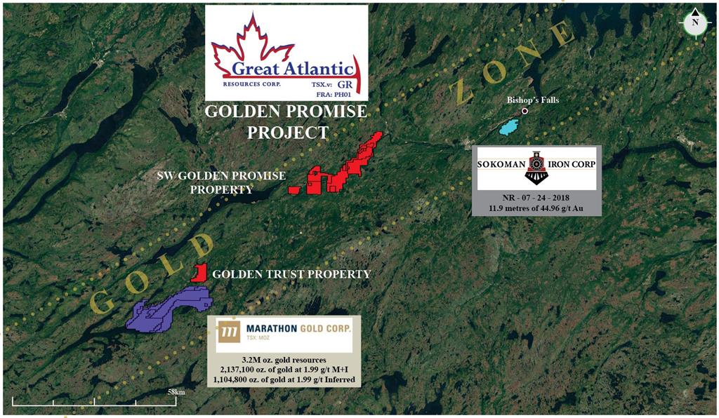
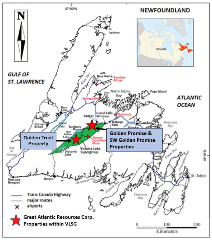
Acquired the Golden Trust Property through staking
1 kilometer north of the Valentine Lake Gold Camp of Marathon Gold Corp.
Golden Trust Property covers an area of 2,400 hectares in a relatively under-explored area of the central Newfoundland gold belt
VANCOUVER, BC / ACCESSWIRE / March 1, 2019 / GREAT ATLANTIC RESOURCES CORP. (TSXV:GR) (the “Company” or “Great Atlantic”) is pleased to announce it has acquired, through staking, the Golden Trust Property, located in the central Newfoundland gold belt and 1 kilometer north of the Valentine Lake Gold Camp of Marathon Gold Corp. has acquired, through staking, the Golden Trust Property (TSXV:MOZ). The Golden Trust Property covers an area of 2,400 hectares in a relatively under-explored area of the central Newfoundland gold belt. Key points for the Golden Trust Property include:
Located
1 km north of the Valentine Lake Gold Camp of Marathon Gold Corp.,
approximately 44 km southwest of Great Atlantic’s Golden Promise
Property and approximately 31 km southwest of the Duck Pond VMS deposit.
Within
the prospective Victoria Lake Supergroup which hosts numerous
epigenetic gold & volcanogenic massive sulfide occurrences
(including Duck Pond VMS deposit).
Within
the Exploits Subzone of the Dunnage Zone and east of the Red Indian
Line (RIL), a major (Appalachian-scale) collisional boundary, and suture
zone.
Government till samples (2008) returned elevated to anomalous values for gold in various regions of the Golden Trust Property.
The
Golden Trust Property occurs within an under-explored area of the
Newfoundland central gold belt. Company management have been unable to
locate any reports of historic diamond drilling within the property.
Till geochemical sampling conducted by the Newfoundland Department of
Natural Resources in 2008 included a small number of wide-spaced samples
within the Golden Trust Property. Samples from various regions of the
property returned elevated to anomalous values for gold including in the
5-9 parts per billion range.
The southern boundary of the
property is located 1 kilometer north of the northeast region of the
Valentine Lake Gold Camp of Marathon Gold Corp. (TSXV:MOZ).
As reported on Marathon’s website, the Valentine Lake Gold Camp
currently hosts four near-surface, mainly pit-shell constrained,
deposits with measured and indicated resources totaling 2,691,400 oz. of
gold at 1.85 g/t gold and inferred resources totalling 1,531,600 oz. of
gold at 1.77 g/t. The Golden Trust Property is located approximately 44
kilometers southwest of Great Atlantic’s Golden Promise Gold Property
which hosts multiple gold bearing quartz vein systems.
The
Company’s Golden Trust and Golden Promise Properties and the Valentine
Lake Gold Camp of Marathon Gold Corp. all occur within the Exploits
Subzone of the Dunnage Zone. The Red Indian Line (RIL), a major
(Appalachian-scale) collisional boundary, and suture zone, forms the
western boundary of the Exploits Subzone.
The Golden Trust
Property occurs within the Victoria Lake Supergroup (VLSG), a
volcano-sedimentary terrane within the Exploits Subzone. The VLSG hosts
numerous volcanogenic massive sulfide (VMS) and epigenetic gold
occurrences. The most significant of the VMS deposits within the VLSG is
the Duck Pond deposit (zinc, lead, copper, silver and gold), located
approximately 31 kilometers northeast of the Golden Trust Property.
Readers
are warned that mineralization at the Valentine Lake Gold Camp, Golden
Promise Property, Duck Pond Deposit and elsewhere within the Exploits
Subzone and VLSG is not necessarily indicative of mineralization within
the Golden Trust Property.
David Martin, P.Geo., a Qualified
Person as defined by NI 43-101 and VP Exploration for Great Atlantic, is
responsible for the technical information contained in this News
Release.
About Great Atlantic Resources Corp.: Great
Atlantic Resources Corp. is a Canadian exploration company focused on
the discovery and development of mineral assets in the resource-rich and
sovereign risk-free realm of Atlantic Canada, one of the number one
mining regions of the world. Great Atlantic is currently surging forward
building the company utilizing a Project Generation model, with a
special focus on the most critical elements on the planet that are
prominent in Atlantic Canada, Antimony, Tungsten and Gold.
On Behalf of the board of directors
“Christopher R Anderson”
Mr. Christopher R. Anderson “Always be positive, strive for solutions, and never give up” President CEO Director 604-488-3900 – Dir
Posted by AGORACOM
at 8:30 AM on Friday, March 1st, 2019
The recently completed drilling in phase 2 identified a series of 30 epithermal veins
Approximately 1000m to the northeast, the SG3 Target area, is a structural intersection mapped and sampled by the geological survey of Mexico which is a feeder system type target.
Now that we have established that there is a large cluster of epithermal veins at Tabasquena, we are also eager to explore for feeder system type targets. Our plan to drill deeper into the vein system to look for the boiling point in our epithermal veins
About Advance Gold Corp. (TSXV: AAX)
Advance Gold is a TSX-V listed junior exploration company focused on
acquiring and exploring mineral properties containing precious metals.
The Company acquired a 100% interest in the Tabasquena Silver Mine in
Zacatecas, Mexico in 2017, and the Venaditas project, also in Zacatecas
state, in April, 2018.
The Tabasquena project is located near the Milagros silver mine near
the city of Ojocaliente, Mexico. Benefits at Tabasquena include road
access to the claims, power to the claims, a 100-metre underground shaft
and underground workings, plus it is a fully permitted mine.
FULL DISCLOSURE: Advance Gold is an advertising client of AGORA Internet Relations Corp.
For further information, please contact: Allan Barry Laboucan, President and CEO Phone: (604) 505-4753 Email: [email protected]
Posted by AGORACOM
at 1:30 PM on Thursday, February 28th, 2019
Issued 5,691,539 Units, each Unit consisting of 1 common share and 1 common share purchase warrant, each warrant being exercisable at $0.08 for 24 months
Proceeds from the financing will be used to fund the phase 3 drilling at the Tabasquena project near Ojocaliente, Mexico
A key focus of the phase 3 drilling will be to drill deeper and target the boiling zone of the epithermal vein system
Vancouver, British Columbia–(Newsfile Corp. – February 28, 2019) –
Advance Gold Corp. (TSXV: AAX) (“Advance Gold” or “the Company”) is
pleased to announce that it has closed its previously announced private
placement financing (see February 5, 2019 and February 22, 2019 news
releases). The Company has issued 5,691,539 Units, each Unit consisting
of 1 common share and 1 common share purchase warrant, each warrant
being exercisable at $0.08 for 24 months, for gross proceeds of
$369,950. Proceeds from the financing will be used to fund the phase 3
drilling at the Tabasquena project near Ojocaliente, Mexico and for
general corporate purposes.
All securities issued pursuant to the
financing will be subject to a 4 month hold. Finders’ fees have been
paid to certain finders in accordance with TSX Venture Exchange
policies.
The private placement was effected with 1 insider of
the Company subscribing for a total of $75,000, that portion of the
Financing a “related party transaction” as such term is defined under
Multilateral Instrument 61-101 – Protection of Minority Security Holders
in Special Transactions (“MI 61-101”). The Company is relying on
exemptions from the formal valuation and minority approval requirements
set out in MI 61-101. The Company is exempt from the formal valuation
requirement of MI 61-101 under sections 5.5(a) and (b) of MI 61-101 in
respect of the transaction as the fair market value of the transaction,
insofar as it involves the interested party, is not more than 25% of the
Company’s market capitalization. Additionally, the Company is exempt
from minority shareholder approval under sections 5.7(1)(a) and (b) of
MI 61-101 as, in addition to the foregoing, (i) neither the fair market
value of the Units nor the consideration received in respect thereof
from interested party exceeds $2,500,000, (ii) the Company has one or
more independent directors who are not employees of the Company, and
(iii) all of the independent directors have approved the transaction.
Material change reports were not filed 21 days prior to the closing of
the financing because insider participation had not been established at
the time the financing was announced.
Upcoming Drilling
In
the first two phases of drilling, Advance discovered a cluster of
epithermal veins, all but a few of them blind, which suggests this
drilling intersected the top of the epithermal vein system. The results
from the 2 phases of drilling returned significant gold mineralization
(see Press Releases November 1, 2018 and November 6, 2018).
A
key focus of the phase 3 drilling will be to drill deeper and target
the boiling zone of the epithermal vein system. The cluster of veins dip
toward a fault which is considered a key structural feature. A proposed
hole will start from the east side of the fault, drill west, to then go
through the cluster of veins to catch them at the boiling zone.
The
other key focus will be to drill a few shallow holes near a 12 metre
intersection of the Tabasquena vein in the oxides. This vein in the
oxides is much wider than the historical 2-4 metre mining width utilized
by former operator Penoles, which was across 2-4 metres. This
intersection was a 125 metre step out to the north of the old mine
workings and is approximately 75 metres along strike from the 100 metre
deep shaft and headframe. Advance has mining equipment and the
Tabasquena project is fully permitted for mining.
Allan Barry Laboucan, President and CEO of Advance Gold Corp. commented: “Our
team is very excited to get started on our phase 3 drilling program at
the Tabasquena project. We are in the final stages of planning our two
pronged approach to drilling, and will provide more details as we begin
drilling shortly.
“Past historical mining by Penoles in
the oxides had reported high-grade silver, we have stepped out from
their underground workings and found a much wider intersection of the
Tabasquena vein of 12 metres in the oxides. The shallow holes will help
us understand the near surface potential. There are plenty of streaming
and royalty companies looking for near term production projects to
invest in, yet a small group to choose from. Our timing to test the near
surface potential is very good.
“Our deep hole will test
the depth potential of the cluster of epithermal veins we have hit in
the first 2 phases of drilling. Zonation of grade along the vertical and
horizontal is common in epithermal vein systems, our deeper hole will
help us understand down to the boiling zone of the system.”
Julio
Pinto Linares is a QP, Doctor in Geological Sciences with specialty in
Economic Geology and Qualified Professional No. 01365 by MMSA., for
Advance Gold and is the qualified person as defined by National
Instrument 43-101 responsible for the accuracy of technical information
contained in this news release.
About Advance Gold Corp. (TSXV: AAX)
Advance
Gold is a TSX-V listed junior exploration company focused on acquiring
and exploring mineral properties containing precious metals. The Company
acquired a 100% interest in the Tabasquena Silver Mine in Zacatecas,
Mexico in 2017, and the Venaditas project, also in Zacatecas state, in
April, 2018.
The Tabasquena project is located near the Milagros
silver mine near the city of Ojocaliente, Mexico. Benefits at Tabasquena
include road access to the claims, power to the claims, a 100-metre
underground shaft and underground workings, plus it is a fully permitted mine.
Venaditas
is well located adjacent to Teck’s San Nicholas mine, a VMS deposit,
and it is approximately 11km to the east of the Tabasquena project,
along a paved road.
In addition, Advance Gold holds a 14.53%
interest on strategic claims in the Liranda Corridor in Kenya, East
Africa. The remaining 85.47% of the Kakamega project is held by Acacia
Mining (63% owned by Barrick Gold).
For further information, please contact:
Allan Barry Laboucan, President and CEO Phone: (604) 505-4753 Email: [email protected]
Posted by AGORACOM
at 10:20 AM on Thursday, February 28th, 2019
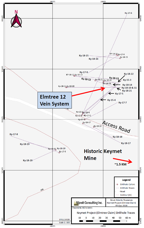
Drilling occurred in northwest region of the property, 1.5 km NW of the historic Keymet Mine.
Ky-18-14: 7.89% zinc equivalent over 34.3 meters (From 46.20 m to 80.50 m)
Elmtree 12 vein: System traced to approximately 145 meters depth, open at depth
Elmtree 12 vein: Strike length of approximately 110 meters and open along strike
The Company’s focus since acquiring the Keymet Property is the area of reported polymetallic veins with most work in the area of the Elmtree 12 copper-lead-zinc-silver bearing vein system.
At least seven vein occurrences with lead, zinc and +/- copper, silver and gold are reported in this region of the property in addition to the polymetallic veins reported at the historic Keymet Mine
FULL DISCLOSURE: Great Atlantic is an advertising client of AGORA Internet Relations Corp
Posted by AGORACOM
at 9:57 AM on Wednesday, February 27th, 2019
Received all analytical results from the 2018 exploration program at its Golden Promise Property, located in the central Newfoundland gold belt
The results identified additional exploration targets where no prior drilling has taken place
VANCOUVER, BC / ACCESSWIRE / February 27, 2019 / GREAT ATLANTIC RESOURCES CORP. (TSXV.GR) (the “Company” or “Great Atlantic”) is pleased to announce it has received all analytical results from the 2018 exploration program at its Golden Promise Property, located in the central Newfoundland gold belt, the results identifying additional exploration targets. The 2018 soil and rock analytical results confirm gold soil anomalies +/- rock samples anomalous in gold in at least three additional target areas in under-explored regions of the property. The Company’s main focus on the property remains the Jaclyn Zone where multiple gold bearing quartz vein systems occur. Gold bearing veins and gold bearing quartz vein boulders occur in other regions of the property.
Anomalous 2018 rock and soil samples were concentrated in three new targets areas:
Southwest
region: Anomalous soil samples along two reconnaissance soil lines, up
to 77 ppb gold (News Release of September 27, 2018). All 11 samples
along one 570- meter long line returned anomalous gold values. Rock
samples within the soil anomaly retuned anomalous gold values including
1.04 g/t gold.
East-Central region:
Anomalous soil samples (up to 39 ppb gold) & rock float samples (up
to 136 ppb gold) along a reconnaissance traverse.
West-Central
region: Anomalous soil samples (up to 41 ppb) following up in an area
of 2017 soil anomalies (212 and 236 ppb gold).
No previous drilling in the new target areas.
The
2018 program was reconnaissance in nature consisting of prospecting and
soil / rock geochemical sampling in multiple under-explored regions of
the Golden Promise Property. Multiple gold soil anomalies were
identified in the southwest, west-central and east-central regions of
the property, thereby adding to the number of gold targets within the
property. Rock grab samples from float in the east-central and southwest
regions of the property returned anomalous values for gold, the high
value being 1.04 g/t gold.
Soil sample analytical results from the
southwest region of the Golden Promise Property were reported in the
Company’s News Release of September 27, 2018. The
results include anomalous gold in soil samples from a new target area in
this southwest region. The majority of soil samples from two
reconnaissance lines in this target area returned anomalous values for
gold (up to 77 parts per billion (ppb) gold) including all 11 samples
from one approximately 570-meter long line. Nine of the 2018 rock grab
samples (float and outcrop) from this anomalous zone returned anomalous
gold values, the high value being a boulder sample with quartz veins
returning 1.04 g/t gold.This anomalous zone is
approximately 4 kilometers northeast of the Linda / Snow White gold
bearing vein which is located within the southwest region of the
property. Reported historic highlights for the Linda / Snow White vein
include a 232 g/t gold grab sample, 29.7 g/t gold over 0.5 meters in a
channel sample and 19.5 g/t gold over 1.15 meters during diamond
drilling (core length).
Quartz boulder in new southwest target area
The
2018 program confirmed an area of gold soil anomalies in the
west-central region of the property. Initial reconnaissance soil
sampling by the Company in this region during 2017 identified gold
anomalies (including samples returning 212 and 236 ppb gold). Soil
sampling in this area was continued during 2018 along 2 north-south
lines. Six of seven soil samples from an approximately 300-meter long
section of one line returned anomalous values for gold in the 8-41 ppb
gold range, confirming this new target area. This zone of gold soil
anomalies is located approximately 1 kilometer northwest of the gold
bearing Shawn’s Shot quartz vein. A 0.32-meter long chip sample
collected by the Company across the Shawn’s Shot vein in 2017 returned
48.2 g/t gold (News Release of August 28, 2017).
The 2018 program
established a new gold target area in the east-central region of the
property. Prospecting and soil sampling were conducted along one
east-west reconnaissance line in this region. Approximately 25% of the
soil samples along an approximately 2-kilometer section of this line
returned anomalous values for gold (6-39 ppb gold). Rock samples from
quartz boulders in this region returned anomalous values for gold (up to
136 ppb gold). The target area is approximately 2.2 kilometers
south-southwest of the gold bearing Jaclyn Main Zone. The Jaclyn Main
Zone has been the primary focus of historic gold exploration on the
property.
The Company recently reported a National Instrument
43-101mineral resource estimate for the Jaclyn Main Zone, located in the
northern region of the property (News Release of December 6, 2018; and
Sedar-filed National Instrument 43-101 Technical Report on the Golden
Promise Property, Central Newfoundland (revised), dated December 4, 2018
by Mr. Greg Z. Mosher, M.Sc. App., P.Geo., and Mr. Larry Pilgrim,
B.Sc., P.Geo.). The reported inferred mineral resource estimate for the
Jaclyn Main Zone is as follows:
Resource
Cutoff Au g/t
Au Cap g/t
Au Uncap g/t
Tonnes
Au Ounces Capped
Au Ounces Uncapped
Total
1.1
9.3
10.4
357,500
106,400
119,900
Pit-Constrained
0.6
11.4
14.1
157,300
57,800
71,200
Underground
1.5
7.5
7.6
200,200
48,600
48,700
Mineral Resources are not Mineral Reserves and do not have demonstrated economic viability.
There is no certainty that all or any part of the Mineral Resources estimated will be converted into Mineral Reserves.
Mineral
resource tonnage and contained metal have been rounded to reflect the
accuracy of the estimate, and numbers may not add due to rounding.
Mineral resource tonnage and grades are reported as undiluted.
Contained Au ounces are in-situ and do not include recovery losses
The
Jaclyn Main Zone is part of the Jaclyn Zone. At least 5 gold bearing
quartz vein systems are reported at the Jaclyn Zone, including the
Jaclyn Main Zone, Jaclyn North Zone, Jaclyn South Zone, Jaclyn East Zone
and Jaclyn West Zone. Much of the reported historical exploration
within the property has been focused on the Jaclyn Zone with the
majority of historic drill holes (2002-2010) at the Jaclyn Main Zone.
Other gold bearing veins within the property include Shawn’s Shot, Linda
/ Snow White and at the Gabbro Occurrence. High grade quartz boulders
are reported within the property including at the Jaclyn Zone and
Branden and Justin’s Hope boulder occurrences.
The property is
located within the Exploits Subzone of the Newfoundland Dunnage Zone.
Within the Exploits Subzone, the property lies along the
north-northwestern fringe of the Victoria Lake Supergroup (VLSG), a
volcano-sedimentary terrane. The northwestern margin of the Golden
Promise Property occurs proximal to, and, in part, contiguous with a
major (Appalachian-scale) collisional boundary, and suture zone, known
as the Red Indian Line (RIL). The RIL forms the western boundary of the
Exploits Subzone. Recent significant gold discoveries in this region of
the Exploits Subzone include those of Sokoman Iron Corp. (TSXV.SIC) at the Moosehead Project and Marathon Gold Corp. (TSXV.MOZ) at the Valentine Lake Gold Camp.
Sokoman Iron Corp. (TSXV.SIC) recently
announced a high-grade gold discovery on its Moosehead Property,
located approximately 40 kilometers east-northeast of the Golden Promise
Property. The discovery was made during the 2018 diamond drilling
program. A drill intersection of 44.96 g/t gold over 11.90 meters core
length was reported including a 1.35 meters core length quartz vein
intersection of 385.85 g/t gold (Sokoman Iron Corp. News Release of July
24, 2018). The Valentine Lake Gold Camp of Marathon Gold Corp. (TSXV.MOZ) is
located approximately 55 kilometers southwest of the Golden Promise
Property. As reported on Marathon’s website, the Valentine Lake Gold
Camp currently hosts four near-surface, mainly pit-shell constrained,
deposits with measured and indicated resources totaling 2,691,400 oz. of
gold at 1.85 g/t gold and inferred resources totalling 1,531,600 oz. of
gold at 1.77 g/t. Readers are warned that mineralization at the
Moosehead Property and Valentine Lake Gold Camp is not necessarily
indicative of mineralization on the Golden Promise Property.
As
reported in the National Instrument 43-101 Technical Report on the
Golden Promise Property, Central Newfoundland (revised), dated December
4, 2018 by Mr. Greg Z. Mosher, M.Sc. App., P.Geo., and Mr. Larry
Pilgrim, B.Sc., P.Geo., the Jaclyn Main Zone was modelled as a single
quartz vein that strikes east-west and dips steeply to the south.
Modelled vein thickness was based on true thickness derived from quartz
vein intercepts. The estimate is based on 220 assays that were
composited to 135 one-meter long composites. A bulk density of 2.7 g/cm3
was used. Blocks in the model measured 15 meters east-west, 1-meter
north-south and 10 meters vertically. The block model was not rotated.
Grades were interpolated using inverse-distance squared (ID2) weighting
and a search ellipse that measured 100 meters along strike, two meters
across strike and 50 meters vertically. Grades were interpolated based
on a minimum of two and a maximum of 10 composites with a maximum of one
composite per hole so the grade of each block is based on at least two
drillholes thereby demonstrating continuity of mineralization. For the
capped mineral resource estimate, all assays that exceed 65 g/t gold
were capped at 65 g/t gold. All resources were classified as Inferred
because of the relatively wide spacing of drill holes through most of
the zone.
Because part of the vein is near surface the resource
estimate was constrained by a conceptual open pit to demonstrate
reasonable prospects of eventual economic extraction. Generic mining
costs of US$2.50/tonne and processing costs of US$25.00/tonne were used
together with a gold price of US$1,300/ounce. A conceptual pit slope of
45° was assumed with no allowance for mining loss or dilution. Based on
the combined hypothetical mining and processing costs and the assumed
price of gold, a pit-constrained cutoff grade of 0.6 g/t was adopted.
For the underground portion of the resource a cutoff of 1.5 g/t was
assumed. The cutoff grade for the total resource is the weighted average
of the pit-constrained and underground cutoff grades.
The
2018 rock and soil samples were analyzed by Eastern Analytical Ltd. in
Springdale, NL for gold by Fire Assay and for 34 elements by ICP. A
qualified person managed and conducted the 2018 exploration program.
Readers
are warned that historical records referred to in this News Release
have been examined but not verified by a Qualified Person. Further work
is required to verify that historical records referred to in this News
Release are accurate.
David Martin, P.Geo., a Qualified Person as
defined by NI 43-101 and VP Exploration for Great Atlantic, is
responsible for the technical information contained in this News
Release.
About Great Atlantic Resources Corp.: Great
Atlantic Resources Corp. is a Canadian exploration company focused on
the discovery and development of mineral assets in the resource-rich and
sovereign risk-free realm of Atlantic Canada, one of the number one
mining regions of the world. Great Atlantic is currently surging forward
building the company utilizing a Project Generation model, with a
special focus on the most critical elements on the planet that are
prominent in Atlantic Canada, Antimony, Tungsten and Gold. On Behalf of the board of directors
“Christopher R Anderson“
Mr. Christopher R. Anderson “Always be positive, strive for solutions, and never give up” President CEO Director 604-488-3900 – Dir
Posted by AGORACOM
at 8:33 AM on Wednesday, February 27th, 2019
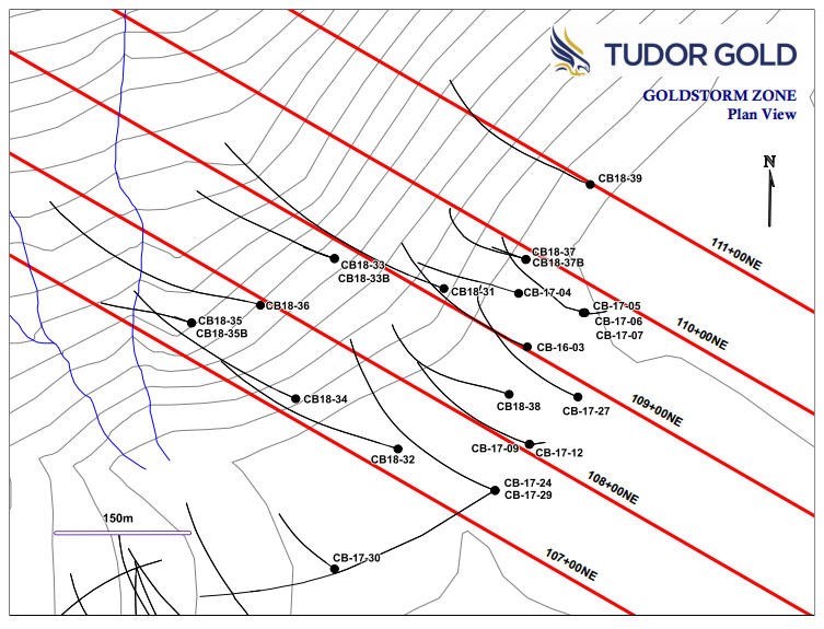
JV partner Tudor Gold has updated information from the southern part of the Goldstorm Zone on the Treaty Creek property in the Golden Triangle
Significant horizons of stronger gold mineralization occur in a thick envelope of low-grade gold mineralization throughout the entire Goldstorm Zone.
Within the low-grade mineralized body, near-surface horizons of stronger gold grades occur.
CB-17-24 interval averages 0.945 g/t Au over 213.0 meters,including the core of the zone that averages 1.925 g/t Au over a 60 meter interval.
Cardston, Alberta–(Newsfile Corp. – February 27, 2019) – American Creek Resources Ltd. (TSXV: AMK) (the “Company”)is
pleased to announce that JV partner Tudor Gold has updated information
from the southern part of the Goldstorm Zone on the Treaty Creek
property in the Golden Triangle region of British Columbia. New
composites from drill holes completed during 2017 and 2018 demonstrate
that significant horizons of stronger gold mineralization occur in a
thick envelope of low-grade gold mineralization throughout the entire
Goldstorm Zone.
Within
the low-grade mineralized body, near-surface horizons of stronger gold
grades occur. The southernmost drill section, 107+00 NE (attached below)
demonstrates that the Goldstorm Zone contains a higher grade gold
interval at its eastern near-surface projection in hole CB-17-24. This
enriched gold interval averages 0.945 g/t Au over 213.0 metersincluding the core of the zone that averages 1.925 g/t Au over a 60 meter interval.
Similarly, the upper part of the gold intercepts in holes CB18-32 and
CB18-34 also demonstrate that the stronger gold mineralization occurs in
the upper portion of each intercept. The following table gives gold
composites from the three drill holes on Section 107+00 NE that cut the
Goldstorm Zone.
To view an enhanced version of this graphic, please visit: https://orders.newsfilecorp.com/files/682/43074_39f1da8cb467c8d9_001full.jpgTudor
Gold Exploration Manager Ken Konkin stated: “We consistently see thick,
low-grade gold intercepts that contain distinct horizons of stronger
gold mineralization throughout the entire Goldstorm Zone. Our
preliminary petrographic studies confirm that gold mineralization is
associated with multiple pulses of disseminated and veinlet pyrite
emplacement. These events were then over-printed and mineralized by
late-stage, steep-angled, quartz-calcite-pyrite veinlets that contain
native gold. The hanging wall of the Goldstorm Zone is well defined by a
sharp fault contact. This appears to be a moderately dipping regional
thrust fault similar to the orientation and nature of the Sulphurets
Thrust Fault hanging wall contact at Seabridge’s Iron Cap deposit,
located five kilometers to the southwest.” Goldstorm
extends for at least 500 meters along a northeastern strike and is open
to the east, north and down dip. A drill plan map showing the locations
of drill hole collars and section lines is included below in the
attached Section 107+00NE. Drill hole CB18-35B stopped within the fault
zone and therefore did not penetrate the gold zone. In the following
weeks, geologists will be planning an aggressive diamond drill hole
program for the 2019 exploration season in order to fast-track the
advancement of the Treaty Creek Project. Tudor
Gold will be displaying core samples and drill sections at booth #3314
at the Prospectors and Developers Association of Canada convention in
Toronto March 3-6, 2019.
To view an enhanced version of this graphic, please visit: https://orders.newsfilecorp.com/files/682/43074_39f1da8cb467c8d9_003full.jpgQA/QCIn
2016 and 2017, drill core samples were prepared and analyzed at
Activation Laboratories Ltd. in Kamloops, BC. In 2018, drill core
samples were prepared ALS Global’s Preparation Laboratory in Terrace, BC
and assayed at ALS Global’s Geochemical Laboratory in North Vancouver,
BC. Analytical accuracy and precision are monitored by the submission of
blanks, certified standards and duplicate samples inserted at regular
intervals into the sample stream by Tudor Gold personnel. Activation
Laboratories and ALS Global Laboratories quality systems comply with the
requirements for the International Standards ISO 17025: 2005. QP The
Qualified Person for this new release for the purposes of National
Instrument 43-101 is Tudor Gold’s Exploration Manager, Ken Konkin,
P.Geo. He has read and approved the scientific and technical information
that forms the basis for the disclosure contained in this news release. About American Creek
American
Creek holds a strong portfolio of gold and silver properties in British
Columbia. Three of those properties are located in the prolific “Golden
Triangle”; the Treaty Creek and Electrum joint venture projects with
Tudor Gold (Walter Storm) as well as the 100% owned past producing
Dunwell Mine.
The Corporation also holds
the Gold Hill, Austruck-Bonanza, Ample Goldmax, Silver Side, and
Glitter King properties located in other prospective areas of the
province.
For further information please contact Kelvin Burton at: Phone: 403 752-4040 or Email: [email protected]. Information relating to the Corporation is available on its website at www.americancreek.comNeither
TSX Venture Exchange nor its Regulation Services Provider (as that term
is defined in the policies of the TSX Venture Exchange) accepts
responsibility for the adequacy or accuracy of this release. Cautionary Statements regarding Forward-Looking Information Certain
statements contained in this press release constitute forward-looking
information. These statements relate to future events or future
performance. The use of any of the words “could”, “intend”, “expect”,
“believe”, “will”, “projected”, “estimated” and similar expressions and
statements relating to matters that are not historical facts are
intended to identify forward-looking information and are based on the
Company’s current belief or assumptions as to the outcome and timing of
such future events. Actual future results may differ materially. All
statements including, without limitation, statements relating to the
Goldstorm Zone as well as any other future plans, objectives or
expectations of the Company are forward-looking statements that involve
various risks and uncertainties. There can be no assurance that such
statements will prove to be accurate and actual results and future
events could differ materially from those anticipated in such
statements. Important factors that could cause actual results to differ
materially from the Company’s plans or expectations include risks
relating to the actual results of current exploration activities,
fluctuating gold prices, possibility of equipment breakdowns and delays,
exploration cost overruns, availability of capital and financing,
general economic, market or business conditions, regulatory changes,
timeliness of government or regulatory approvals and other risks
detailed herein and from time to time in the filings made by the Company
with securities regulators. The Company expressly disclaims any
intention or obligation to update or revise any forward-looking
statements whether as a result of new information, future events or
otherwise except as otherwise required by applicable securities
legislation.