- Holes COD18-67 and COD18-70 re-analyzed for exceeding the upper 500 (g/t) analytical limit for tellurium
- New analytical results confirm high grade tellurium within the high-grade gold and silver intersections.
- COD18-67, (7.28 meters core length) graded 823.4 g/t tellurium
- COD18-70, (6.90 meters core length) graded 640.5 g/t Tellurium
VANCOUVER, BC / ACCESSWIRE / March 18, 2019 / GGX Gold Corp. (TSX-V: GGX), (OTCQB: GGXXF), (FRA: 3SR2) (the “Company” or “GGX“) is pleased to announce it has received tellurium analytical results for select drill core samples from the Fall 2018 diamond drill program at the Gold Drop Property, located in southern British Columbia. The Fall 2018 drill program was conducted at the C.O.D. Vein, located in the Gold Drop Southwest Zone. The tellurium results are re-analyses of drill core samples from drill holes COD18-67 and COD18-70 which initially exceeded the upper 500 grams per tonne (g/t) analytical limit for tellurium. The re-analyses confirm high-grade tellurium for these drill holes, being associated with high-grade gold and silver (gold and silver results reported in News Releases of January 11 and 18, 2019):
- COD18-67: 129 g/t gold, 1154 g/t silver & 823 g/t tellurium over 7.28-meter core length
- COD18-70: 107 g/t gold, 880 g/t silver & 640 g/t tellurium over 6.90-meter core length

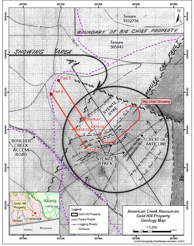
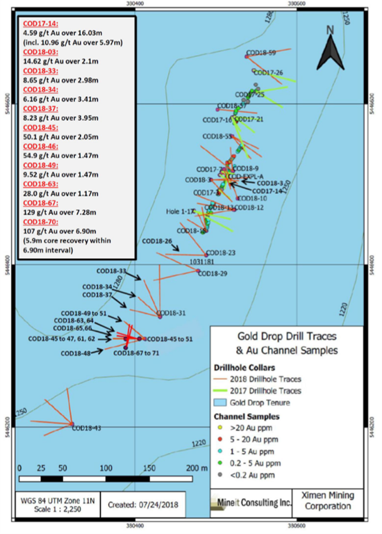
The 2018 Fall diamond drill program tested the COD vein. The program followed up on results from previous 2018 diamond drilling at the southern extension of the COD vein. The highlights of the 2018 Fall drill program are drill hole COD18-67 which intersected 129.1 g/t gold and 1,154 g/t silver over 7.28 meters core length and drill hole COD18-70 which intersected 107.5 g/t gold and 880 g/t silver over 6.90 meters core length (News Releases of January 11and 18, 2019). Both holes were drilled slightly northeast from the same site (COD18-67 at a 50-degree dip and COD-18-70 at a 54-degree dip) to intersect the northwest trending COD Vein at a shallower angle, the objective to test the continuity of the quartz veining and mineralization.
Fourteen drill core samples from the high-grade gold and silver intersections of drill holes COD18-67 and COD18-70 returned greater than the upper analytical limit of 500 g/t for tellurium during initial analysis (four acid ICP-MS analysis by ALS Canada Ltd. in North Vancouver). As a result, the tellurium weighted average grades for these intersections could not be determined from initial analyses. ALS Canada Ltd. recently re-analyzed these 14 samples for tellurium by four acid ICP-AES. These new analytical results confirm high grade tellurium within the high-grade gold and silver intersections. For drill hole COD18-67, the near-surface interval of 23.19-30.47m (7.28 meters core length) graded 823.4 g/t tellurium. For drill hole COD18-70, the near-surface interval of 22.57-29.47m (6.90 meters core length) graded 640.5 g/t Tellurium. The 14 drill samples are listed as follows (core length):
| Hole No. | From (m) | To (m) | Length (m) | Te (G/T) | Sample No. |
| COD18-67 | 23.58 | 23.95 | 0.37 | 880 | V108489 |
| COD18-67 | 24.50 | 25.10 | 0.60 | 560 | V108491 |
| COD18-67 | 25.10 | 25.50 | 0.40 | 770 | V108492 |
| COD18-67 | 25.50 | 26.06 | 0.56 | 900 | V108493 |
| COD18-67 | 26.06 | 26.34 | 0.28 | 930 | V108494 |
| COD18-67 | 26.34 | 26.72 | 0.38 | 2,250 | V108495 |
| COD18-67 | 26.72 | 27.10 | 0.38 | 3,860 | V108496 |
| COD18-67 | 27.10 | 27.63 | 0.53 | 1,550 | V108497 |
| COD18-67 | 29.70 | 30.04 | 0.34 | 1,090 | V108503 |
| COD18-67 | 30.04 | 30.47 | 0.43 | 710 | V108504 |
| COD18-70 | 22.57 | 22.95 | 0.38 | 690 | V108537 |
| COD18-70 | 23.30 | 23.75 | 0.45 | 3,340 | V108539 |
| COD18-70 | 23.75 | 24.15 | 0.40 | 2,960 | V108541 |
| COD18-70 | 26.19 | 26.98 | 0.79 | 830 | V108544 |


Intersections for 2017 and 2018 diamond drill holes at the C.O.D. vein include the following (please refer to the Company’s website for News Releases announcing these results):
| Hole ID | Interval Length (m) | Gold (gpt) | Silver (gpt) | Te (gpt) |
| COD17-14 | 16.03 | 4.59 | 38.64 | |
| COD18-3 | 2.1 | 14.62 | 150.2 | 102 |
| COD18-26 | 1.4 | 10.3 | 1.09 | 0.24 |
| COD18-32 | 1.51 | 3.67 | 67.2 | 30.4 |
| COD18-33 | 2.98 | 8.65 | 47.6 | 37.3 |
| COD18-34 | 3.41 | 6.16 | 72.4 | 31 |
| COD18-37 | 3.95 | 8.23 | 67.36 | 38.53 |
| COD18-45 | 2.05 | 50.15 | 375 | |
| COD18-46 | 1.47 | 54.9 | 379 | |
| COD18-49 | 1.47 | 9.52 | 118 | 72.2 |
| COD18-54 | 1.66 | 7.6 | 60.2 | 34.1 |
| COD18-61 | 1.38 | 5.29 | 32.4 | 31.4 |
| COD18-63 | 1.17 | 28 | 424.7 | 150.4 |
| COD18-67 | 7.28 | 129.1 | 1,154.90 | 823 |
| COD18-68 | 2.76 | 8.77 | 85.4 | 56.3 |
| COD18-69 | 7.46 | 5.76 | 67.9 | 61.2 |
| COD18-70 | 6.9 | 107.5 | 880 | 640 |
Tellurium remains as one of the rarest elements on earth. Tellurium production has been a by-product of copper and gold mining. The production is limited, estimated to being on the order of 800 metric tonnes per year. According to the USGS total production for 2007 was 107 Mtonnes.
Up to recently, the sole use of tellurium has been alloying of other metals to increase the machinability of copper or to decrease the corrosive action of sulfuric acid on lead.
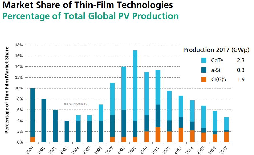
The most significant modern use of tellurium is the Cadmium-telluride (Cd-Te) photovoltaic solar cells. These solar cells are the forefront of solar power. One gigawatt (GW) of Cd-Te, at current efficiencies, would require approximately 93 metric tons of tellurium. These cells have the smallest carbon footprint and the shortest energy payback time of all solar cells. The efficiency of technology is constantly improving and the Cd-Te now takes up 5.1% of worldwide PV production.

PHOTOVOLTAICS REPORT, Freiburg, 27 August 2018
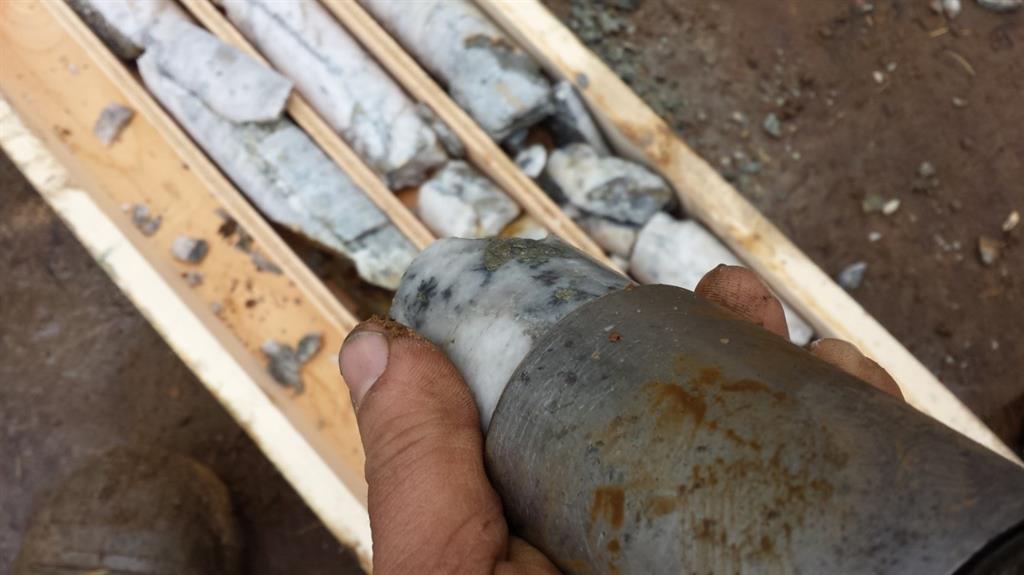
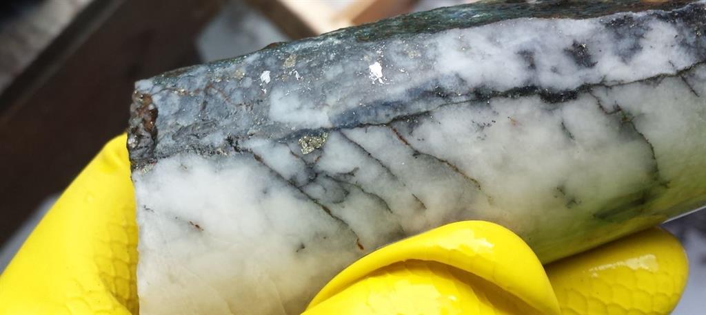
In the C.O.D vein system the tellurium occurs as a soft silver-grey telluride mineral. The telluride mineral is a Silver-Tellurium-Gold alloy speculated to be sylvanite. Whenever this mineral is observed in the drill core the interval has elevated silver, gold and tellurium values.
David Martin, P.Geo., a Qualified Person as defined by NI 43-101 and consultant for GGX Gold Corp., is responsible for the technical information contained in this News Release.
To view the Original News release with pictures please go to the website or contact the Company.
On Behalf of the Board of Directors,
Barry Brown, Director
604-488-3900
Investor Relations: Mr. Jack Singh, 604-488-3900 [email protected]