
- Received licensing documentation from the Icelandic government confirming that a definitive license to conduct mineral exploration on the Trollaskagi permit
- Identified as EL06, granted to the company in July
Montreal, Quebec / August 17, 2017 – St-Georges Platinum and Base Metals Ltd. (CSE: SX) (OTC: SXOOF) (FSE: 85G1) is pleased to announce that it has received licensing documentation from the Icelandic government confirming that a definitive license to conduct mineral exploration on the Trollaskagi permit, identified as EL06, was granted to the company in July.
As per press release dated March 16, 2017, St-Georges gained control, directly or indirectly, of all the active mineral tenures in Iceland through the acquisition of Iceland Resources EHF. The newly granted exploration license covers 1017.7 square kilometers and is located in northern Iceland near the town of Akureyri. The area is fairly accessible; tracks and roads encompass the majority of the permitted zone. The Company can also rely on the infrastructure of nearby municipalities.
Figure 1. Location of the Trollaskagi license in Iceland

Click Image To View Full Size
Peaks in the region reach 1,538 meters above sea level. The area is characterized by calderas containing extensive rhyolite and low temperature zeolite alteration. A considerable reconnaissance effort was affected here by Melmi (Fleming, 2006) to identify any potential gold occurrences. Trollaskagi is located in an area with a mapped felsic central volcano that has not been explored in work conducted by previous explorers, Teck and Melmi. In 2006, Melmi conducted a program of stream sediment sampling in most of the major valleys using roads, tracks, and foot-traverses for access. Rock samples were also collected where alteration was encountered.
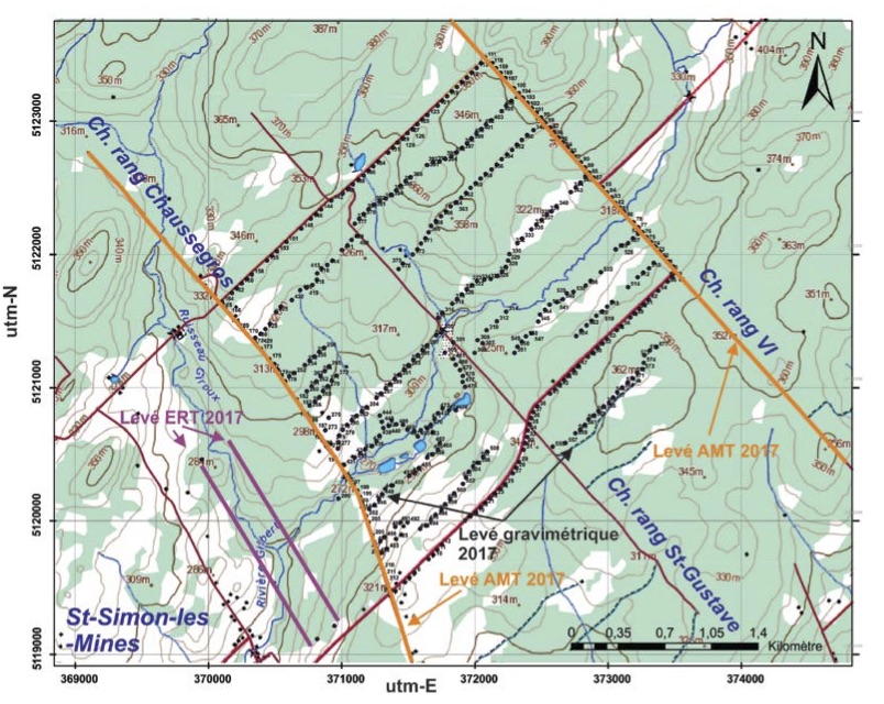
Figure 2. Trollaskagi regional access
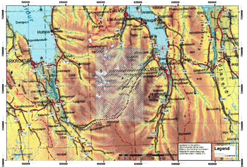
Click Image To View Full Size
The license allows the holder to explore for minerals at surface, to research the dispersion, quantity and the geological and physical characteristics of the metals within the license area.
The license also allows the holder to perform drilling surveys in areas within the specified boundaries as long as the drilling program is submitted to the government and local authorities for compliance review and acceptance. This license does not give the holder permission to exploit a mining operation as mine permitting requires additional licensing reviews.
“(…) We are pleased with the decision of the Icelandic government in the matter of the Trollaskagi license,” said St-Georges’ president, Frank Dumas. “We have designed an initial exploration program for the area, which we expect to execute before the end of the next quarter. Findings will orient further work that should take place in late spring and summer of 2018. This is the second exploration license out of 8 applications that is granted to us and we are looking forward to continue our work in Iceland and move along the balance of our permitting effort (…) Achieving this milestone is essential as it demonstrates the expertise and commitment of our team in Iceland, and the Icelandic Government’s support of the development of the natural resource potential.”
Further information on the work program for Trollaskagi will be detailed in future press releases.
ON BEHALF OF THE BOARD OF DIRECTORS
“Frank Dumas’
FRANK DUMAS, PRESIDENT & CEO
About St-Georges
St-Georges is developing new technologies to solve the biggest environmental problems in the mining industry. If these new technologies are successful, they should improve the financial bottom line of current mining producers. The potential success of these technologies would also involve upgrading certain current known metal resources to economic status while addressing the environmental and social acceptability issues.
The Company control directly or indirectly all of the active mineral tenures in Iceland. It also explores for Nickel on the Julie Nickel Project & for industrial minerals on the Quebec’s North Shore and for Lithium and rare metals in Northern Quebec and in the Abitibi area. Headquartered in Montreal, St-Georges’ stock is listed on the CSE under the symbol SX, on the US OTC under the Symbol SXOOF and on the Frankfurt Stock Exchange under the symbol 85G1. For additional information, please visit our website at www.stgeorgesplatinum.com
The Canadian Securities Exchange (CSE) has not reviewed and does not accept responsibility for the adequacy or the accuracy of the contents of this release.


")


