Agoracom Blog Home

Archive for the ‘Small Cap Lithium Stocks’ Category

Nevada Energy Metals Options-out Second Lithium Project in Nevada $BFF.ca

Posted by AGORACOM-JC at 8:36 AM on Friday, July 15th, 2016

Bff_hub-2_copy

  • Agreed to an Option Agreement where Wildcat Exploration Ltd.
  • Acquire a 100% interest,
  • Subject to a 3% Net Smelter Royalty,
  • 348 mineral claims located in Dixie Valley, Churchill County, Nevada

July 15, 2016 / Vancouver, British Columbia- Nevada Energy Metals Inc. “the Company” (TSX-V: BFF; OTCQB: SSMLF) (Frankfurt: A2AFBV) is pleased to announce that it has agreed to an Option Agreement where Wildcat Exploration Ltd. can acquire a 100% interest, subject to a 3% Net Smelter Royalty, in 348 mineral claims located in Dixie Valley, Churchill County, Nevada. The Option Agreement is “non-arms’ length” and so constitutes a related party transaction, as the Company’s President and CEO, Rick Wilson, is also a director of Wildcat Exploration Ltd., and is subject to TSX Venture Exchange (the “Exchange”) approval.

The DVA 1 to 348 placer claims, having an area of approximately 2,817 hectares/6,960 acres, covers a significant portion of the Humboldt Salt Marsh playa. Of the seven characteristics favorable for the formation of a Lithium brine deposit, as outlined in the USGS deposit model, all seven are found in Dixie Valley. The Lithium deposit model for Dixie Valley is a Clayton Valley style brine deposit.

Pursuant to the terms of the option agreement, Wildcat Exploration Ltd has 36 months within which to exercise the option as follows:

  • -USD $20,000 non-refundable deposit on signing;-USD$ 180,000 payable and 2,000,000 common shares issuable upon Exchange approval;-2,000,000 common shares issuable on the first anniversary date;

    -2,000,000 common shares issuable on the second anniversary date

    -USD$ 1,250,000 in eligible on or before the third anniversary date of the Option Agreement.

In certain instances and subject to Exchange approval, the Company may pay finder’s fees to eligible persons (“Finders”) in regards to the Option Agreement with Wildcat Exploration Ltd., consisting of cash and or common shares.

Dixie Valley Overview

Dixie Valley is located in west central Nevada, about 160 km east northeast of Reno. The entire basin is about 98 km long and up to 16 km wide. Humboldt Salt Marsh occupies the central part of the playa and is about 10 km north-south and 6 km east-west.

Dixie Valley is home to a large and long-lived geothermal system that is still active. The Caithness Dixie Valley geothermal power plant is producing about 64 megawatts of electricity making it the largest geothermal power plant in Nevada. The active geothermal system extends about 30 km roughly north – south along the entire west side of the valley. The heat source appears to be simple very deep circulation into the crust and is not related to igneous activity.

Very little exploration work has been directed at Lithium in this area. Geothermal water in the basin contains up to 4.89 ppm Lithium and stream sediment samples from the adjacent Stillwater range show values to 80 ppm Lithium. Geologically, recent volcanic ash from the Long Valley Caldera (Bishop Tuff) and Mono craters are expected to be found within catchment area of the basin and within the basin fill sediments. One major productive horizon in the Clayton Valley brine field is thought to be Bishop Tuff deposited and preserved in the basin (Zampirro, 2004).

Dixie Valley is a closed fault-bounded basin having the lowest elevation point (1031 m, 3383 ft.) in the Northern Great Basin as measured on the Humboldt Salt Marsh playa. Given the valley has been a closed basin for at least 500,000 years and probably much, much longer, plenty of time has elapsed for evaporative concentration of Lithium bearing geothermal and surface water. The valley appears to be about 2,000 meters deep, primarily filled with poorly sorted coarse conglomerate, gravel, sand and silt with volcanic rocks, and tuff beds, and finer sediments in the lower third of the section (Blackwell et al, 2014).

The conceptual deposit model is as the basin went through multiple wet and dry periods, Lithium dissolved by deep circulating geothermal fluids or leached from local rock units by surface and near surface water, seeped into the basin where it was concentrated by evaporation. Heavier brines sink into the deeper levels of the basin or flow downward along tilted permeable beds, potentially forming subsurface pools of Lithium rich fluids. The process can be likened to an inverted oil field, with the target material being descending fluids caught in gravity traps instead of ascending fluids caught in the tops of structures. This model is somewhat akin to placer gold deposits wherein large areas of very low grade sources are concentrated into economic grades.

The Humboldt Salt Marsh project was acquired for staking cost without royalties and a 200,000 share payment to the locator.

The contents of this news release has been approved by Alan J. Morris CPG who serves as the project geologist and Qualified Person on the Dixie Valley Project.

About Nevada Energy Metals: http://nevadaenergymetals.com/

Nevada Energy Metals Inc. is a well-funded Canadian based exploration company whose primary listing is on the TSX Venture Exchange. The Company’s main exploration focus is directed at Lithium brine targets located in the mining friendly state of Nevada. The Company has recently completed (1) a 70/30 farm-out option JV on 77 claims in Clayton Valley, approximately 250m from the Rockwood Lithium mine, the only brine based Lithium producer in North America; (2) acquisition of 100% of the Teels Marsh West project (100 claims covering 2000 acres/809 hectares) in Mineral County, Nevada; (3) acquisition of 100% ownership of the Black Rock property (128 claims covering 2,560 acres/1,036 hectares) located in southwest Black Rock Desert, Washoe County, Nevada; (4) acquisition of 100% ownership in the San Emidio Project (155 claims, 3,100 acres/1,255 hectares) near Empire, Washoe County, Nevada; (5) the acquisition of the Alkali lake Project, 60% Option from Dajin Resources Corp. (191 claims covering 3,820 acres/1,558 hectares) in the Esmeralda County, Nevada.

On Behalf of the Board of Directors

Rick Wilson, President & CEO

Neither the TSX Venture Exchange nor its Regulation Services Provider (as that term is defined in the policies of the TSX Venture Exchange) accepts responsibility for the contents of this news release.

Disclaimer for Forward-Looking Information:

This news release may contain forward-looking statements which include, but are not limited to, comments that involve future events and conditions such as Exchange approval of the Option Agreement and the Financing and the Company’s ability to exercise the Option or close the Financing, which are subject to various risks and uncertainties. Except for statements of historical facts, comments that address resource potential, upcoming work programs, geological interpretations, receipt and security of mineral property titles, availability of funds, and others are forward-looking. Forward-looking statements are not guarantees of future performance and actual results may vary materially from those statements. Availability of financing, and general business conditions are all factors that could cause actual results to vary materially from forward-looking statements.

Durango Initiates Sampling Program at Dianna Lakesilver Prospect In Saskatchewan $DGO.ca

Posted by AGORACOM-JC at 10:10 AM on Wednesday, July 13th, 2016

Logo

  • Commencing a sampling program this coming week at its 100%-owned Dianna Lake Silver Prospect near Uranium City, Saskatchewan
  • Sampling and mapping program will commence on July 17, 2016 and will take place over approximately one week

Vancouver, BC / July 13, 2016 – Durango Resources Inc. (TSX.V-DGO), (the “Company” or “Durango”) is pleased to announce that it will be commencing a sampling program this coming week at its 100%-owned Dianna Lake Silver Prospect near Uranium City, Saskatchewan.

The Company confirms that the sampling and mapping program will commence on July 17, 2016 and will take place over approximately one week. The program aims to achieve the following goals:

  • -Verify and expand the area of historical anomalous assay values in and around the main Dianna Lake silver showings at Pit #1, Pit #2, and Pit #6 by means of outcrop mapping and sampling, and channel sampling;-Conduct detailed mapping and sampling across the four undrilled and underexplored historically identified IP (induced polarization) anomalies. Historical drilling of two other IP anomalies on the Dianna Lake property defined the bulk of the current zone of mineralization on the property (1); and-Establish the extent of the copper anomalies identified in Pit #7. Historical samples in this location yielded up to 5.87% Cu and 2.6 oz/t Ag (historical sample of up to 5.87% Cu and 2.6 oz/t Ag (1)).

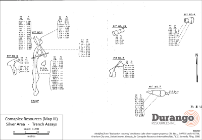
The following historical samples are summarized in an evaluation report prepared for Comaplex Resources Corporation following a drilling, geophysical, and surface sampling program in 1980 (1). Pit dimensions are summarized in Table 1. Historical assay results for the most significant pits are shown below in their entirety in Table 2a and 2b, with a map of the trench locations shown in Figure 1. All samples from the trenches were recorded as grab samples. No significant work has been reported on the property since this program.

Table 1. Dimensions of significant historical trenches

Trench Length (m) # of samples taken Remarks
Pit #1 (main) 14.6 17 Main section of Pit 1
Pit #1 (north extension) 7.1 10 Northern extension of Pit 1
Pit #2 7.4 7
Pit #6 7.8 4
Pit #7 8.4 11

Table 2a. Historical samples from the Dianna Lake property (arranged in order of Ag content)

Pit #1 (Main) Pit #1 (North) Pit #2
Ag (oz/t) % Cu Ag (oz/t) % Cu Ag (oz/t) % Cu
2458.4 336.0 0.05 298.0 0.46
684.4 0.05 225.5 0.14 197.0 0.65
647.4 9.8 0.17 20.4 0.77
600.2 6.0 0.31 20.4 0.02
464.6 0.10 4.1 0.42 16.2 0.26
454.8 3.6 0.36 14.2 0.36
407.2 0.01 3.4 4.92 12.2 0.46
405.4 2.8 0.73
383.4 1.5 0.43
321.0 1.2 0.43
242.6 0.02
240.5
185.0 0.02
56.4
31.0 0.10
17.0 0.02
16.7 0.02

Table 2b. Historical samples from the Dianna Lake property (arranged in order of Ag content)

Pit #6 (Main) Pit #7 (North)
Ag (oz/t) % Cu Ag (oz/t) % Cu
54.6 0.1 8.4 0.19
45.1 0.04 5.0 4.92
18.2 0.05 4.7 2.35
11.1 0.19 3.1 1.15
1.6 0.19 2.6 5.87
2.6 1.18
2.4 1.95
2.3 1.06
2.1 0.62
1.9 0.94
1.5 0.48

(The Company cautions that grab samples are selective and may not be representative of the mineralization on the property.)

Figure 1. Trench locations and historical assays


Click Image To View Full Size

Larger image available at: http://www.durangoresourcesinc.com/dianna-lake-silver-saskatchewan/

About the Dianna Lake Silver Prospect

Durango’s Dianna Lake Silver Prospect covers a historical area in which, from 1968 to 1969, two high-grade, primarily native silver-bearing exploration targets of between 30,000 and 50,000 tonnes grading five to 10 ounces per ton silver, approximately 600 metres apart, were determined by trench grab sample assays, according to a historical evaluation report composed for Comaplex Resources in 1980(1) *.

* Potential quantities and grades are conceptual in nature. There has been insufficient exploration to define a mineral resource and it is uncertain if further exploration will result in the target being delineated as a mineral resource.

Additionally, the main silver-bearing zone is spatially associated with a large zone of low-grade, disseminated copper-silver mineralization in which “drilling of two IP anomalies indicated approximately five million tonnes averaging 0.4 ounce per ton Ag and 0.4 per cent Cu” (undefined category historical resource estimate), according to the same report (1) **.

** A qualified person has not done sufficient work to classify the historical estimate as current mineral resources or mineral reserves and the issuer is not treating the historical estimate as current mineral resources or reserves. Further work must be carried out to verify all historical information before a resource estimate is possible.

Fourteen additional induced polarization anomalies in the historical exploration area surrounding Dianna Lake and the nearby Doug Lake remain yet undrilled, according to the Comaplex Resources report (1), four of which occur within the property boundary of Durango’s Dianna Lake silver project.

Previous work on the claims was reported in 1969, 1980 and 1998 and included diamond drill holes, trenches, and pits primarily across two zones where mineralization was identified at or near surface. One zone was reported to have five trenches exposing Ag-Cu mineralization over approximately 80 metres. Historical grab samples from Pit 1 of this zone included ounce-per-ton silver values of 2,458.4, 684.4, 647.4, 600.2, 464.2, and 454.8 ounces per ton Ag. Out of 18 grab samples, 13 samples assayed between 185.0 and 2,458.4 ounces per ton. Pit 2 grab samples returned reported highs of 298.0 and 197.0 ounce per ton Ag (out of seven samples ranging from 12.2 to 298.0 ounces per ton Ag) (1). (The Company cautions that grab samples are selective and may not be representative of the mineralization on the property.)

The technical contents of this release were approved by Mr. Case Lewis, P.Geo., a qualified person as defined by National Instrument 43-101. The property has not been the subject of a National Instrument 43-101 report.

References

  1. (1)”Evaluation report of the Dianna Lake silver-copper property, CBS 3141, S-97735 and S-97736, Uranium City area, Saskatchewan, Canada, for Comaplex Resources International Ltd.” E.G. Kennedy, PEng, 1980.

About Durango Resources Inc.

Durango is a natural resources company engaged in the acquisition and exploration of mineral properties. The Company has a 100% interest in the Mayner’s Fortune and Smith Island limestone properties in northwest British Columbia, the Decouverte and Trove gold properties in the Abitibi Region of Quebec, and the NMX East, Lac Noirs, Montagne North and Boomerang lithium properties near the Whabouchi mine, the Buckshot graphite property near the Miller Mine in Quebec, the Whitney Northwest property near the Lake Shore Gold and Goldcorp joint venture in Ontario, as well as three sets of claims in the Labrador nickel corridor.

For further information on Durango, please refer to its website and its SEDAR profile at www.sedar.com.

Marcy Kiesman, Chief Executive Officer

Telephone: 604.428.2900 or 604.339.2243

Facsimile: 888.266.3983

Email: [email protected]

Website: www.durangoresourcesinc.com

Forward-Looking Statements

This document may contain or refer to forward-looking information based on current expectations, including, but not limited to future exploration or project development programs and the impact on the Company of these events. Forward-looking information is subject to significant risks and uncertainties, as actual results may differ materially from forecasted results. Forward-looking information is provided as of the date hereof and we assume no responsibility to update or revise them to reflect new events or circumstances. For a detailed list of risks and uncertainties relating to Durango, please refer to the Company’s prospectus filed on its SEDAR profile at www.sedar.com.

Neither TSX Venture Exchange nor its Regulation Services Provider (as that term is defined in the policies of the TSX Venture Exchange) accepts responsibility for the adequacy or accuracy of this release.

PFN Launches 2016 PGM Exploration Program at River Valley Platinum Group Metal Project, Sudbury, Ontario $PFN.ca

Posted by AGORACOM-JC at 9:15 AM on Wednesday, July 13th, 2016

-Field crew mobilized to PFN’s 100% owned River Valley PGM property

-Summer surface exploration followed by fall drill program

-Surface exploration to guide planning of Fall Drill Program, on T2 discovery and exploration for more T2-like discoveries, along the strike to the east and to the south

-River Valley, a primary PGM deposit with 2.5 Moz PGM in near-surface, Measured and Indicated resources, within 100 km of Sudbury – one of Canada’s largest, undeveloped, Primary PGM Reserves.

-Strong infrastructure support, with year-round road access and nearby rail, power and communities

-4 New, 100% owned Lithium Projects, with Pegmatite deposits, in Manitoba and one Brine Exploration Project, Clayton Valley, Nevada

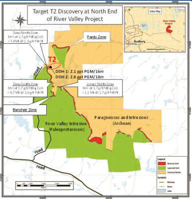
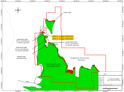
Vancouver, BC / July 13, 2016 – Pacific North West Capital Corp. (“PFN”, the “Company”) (TSX.V: PFN; Frankfurt: P7J.F; OTCQB: PAWEF announces the launch of its 2016 Exploration Program, at its 100% owned River Valley Platinum Group Metal (PGM)-Copper-Nickel Project, near the city of Sudbury, Ontario (Figure 1). PFN’s key objective for 2016 is to follow-up drilling at the high-grade T2 discovery, in order to confirm that it has the potential to warrant resource delineation drilling. To that end, the 2016 Exploration Program consists of two components: 1) a Surface Exploration Program for the summer field season; and 2) a follow-up Diamond Drill Program for the fall. Each of the components will be carried out under Exploration Permit PR-13-10095R and with financial support from the Junior Exploration Assistance Program (JEAP) (see PFN press release dated June 15th, 2016).

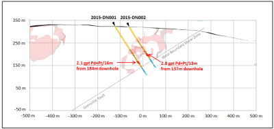
The Surface Exploration Program consists of geological mapping, mineral prospecting, sampling, assaying, litho-structural studies, drill core review and 3D modelling. The program focus is on areas with indications of higher-grade mineralization that remain under-explored. One such priority area is the surface above the T2 discovery (Figure 1). Two holes drilled at T2 in early 2015 (see PFN press release dated March 11, 2015) intersected higher-grade, near-surface PGM mineralization, under cover and in the footwall, to the east of the main mineralized trend at Dana North Zone. Highlights include 2.1 g/t PGM/16m from 184m downhole in Hole 1 and 2.8 g/t PGM/18m from 137m downhole in Hole 2. The T2 Discovery Mineralization remains open, up-dip to surface, at depth and east along the strike for 2 km, to the Pardo Zone (Figure 1). Furthermore, the Pardo Zone itself is mineralized, but also remains under explored.

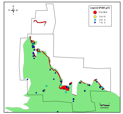
Elsewhere at River Valley, the Surface Exploration Program will cover areas from which previous grab samples, grading up to 60 g/t PGM were taken, and that remain under explored. Previous and new assay data will be integrated with litho-structural data, in order to define the extents of potentially high-grade mineralization, within the main mineralized trend on the basal contact (i.e., Contact Style Mineralization) and internally within the River Valley Intrusion (i.e., Reef Type Mineralization) (Figure 2). In addition, the previous discovery of the Spade Zone (see PFN press release dated June 19, 2012) is to be examined for controls on the apparent thickening of the mineralization at that location (see Azen-Spade Zone in Figure 1). Overall, the Surface Exploration Program, as currently planned, requires 3-4 weeks of field time, from about mid-July to mid-September. The results of the Surface Exploration Program will be used to further guide and refine planning of the fall Diamond Drill Program.

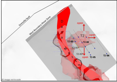
The fall 2016 Diamond Drill Program, as currently planned, consists of four drill holes for a total of 1000m, at the T2 Discovery (Figure 3). The holes are designed to expand the near-surface, high-grade PGM mineralization up-dip, down-dip and eastward along the strike. Pending successful drill results, six additional holes are planned for drilling at T2, in early 2017. That program would then be followed by a Delineation Drill Program, for resource modelling. In addition, drill testing would be carried out on other priority T2-like targets (currently 9 in total) developed along the 12 km strike length of the River Valley PGM deposit, on PFN’s property (Figure 4).

About Pacific North West Capital Corp.

Pacific North West Capital Corp. (TSX.V: PFN; OTCQB: PAWEF; Frankfurt: PJ7) is a mineral exploration company, focused on the Discovery, Exploration and Development of one of Canada’s largest primary Platinum Group Metals (PGM) deposits, the River Valley PGM Project, located in the Sudbury region of Northern Ontario. The Company also has a Lithium Division (Li), with 5 Li Projects.

Management’s corporate philosophy is to be a Project Generator, Explorer and Project Operator, with the objective of Option/Joint Venturing its projects, with major and junior mining companies, through to production. Pacific North West Capital Corp. is a member of the International Metals Group of Companies. For further information on the Company and its projects, please visit: www.PFNCapital.com


Click Image To View Full Size

Figure 1. River Valley location (inset) and property geology maps, showing the position of the Target T2 discovery, at the north end of the PGM deposit (red), between the Dana North Zone to the east and the Pardo Zone to the north. Note: location of the Azen-Spade Zone discovered in 2012 but never followed up.


Click Image To View Full Size

Figure 2. Geological map showing the distribution of surface grab samples with grades of >=1 g/t Pd + Pt (PGM).


Click Image To View Full Size

Figure 3. Map view of 3D models, for the T2 discovery, showing drill collar locations and holes traces, of the four holes planned for drilling in the fall of 2016. In this view, the T2 feature is 100-150m below surface, whereas Dana North is at surface. Holes labelled T2-01 and T2-02 are T2 discovery holes, drilled in early 2015. The T2-03 to T2-03 distance = 50m.


Click Image To View Full Size

Figure 4. Map showing location of three T2-like drill targets at the north end of the River Valley PGM deposit.

About PFN’s Platinum Group Metals Division

River Valley is one of Canada’s largest undeveloped primary PGM deposit.

Achievements to date and future plans for River Valley are outlined below as follows:

  1. 1.PFN currently has 100% ownership in the River Valley Project, subject to a 3% NSR, with options to buy down
  2. 2.Completed exploration and development programs, on the River Valley property, include more than 600 holes drilled since year 2000 and several mineral resource estimates and metallurgical studies;
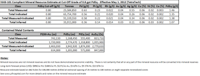
  3. 3.Results for the current (2012) mineral resource estimate are below;
  4. 4.2015 Diamond Drill Program confirms new high grade T2 discovery
  5. 5.Exploration and development plans outlined for 2016
  6. 6.Ongoing strategic partner search for River Valley Project
  7. 7.Results for the most recent Mineral Resource Estimate are summarized below:

– Prepared by Tetra Tech (Wardrop)

– High Confidence: Measured plus Indicated = 72% of total

– Reported on PdEq basis: Pd=40% & Pt=20% of the Payable Metals

– Pd to Pt ratio = 2.5:1; Cu to Ni ratio = 3:1

– High Grade potential, particularly in the north part of River Valley deposit

– Resources under evaluation for development potential as open pit mining operation


Click Image To View Full Size


Click Image To View Full Size

  1. 8.Results for the 2015 Discovery Drill Program on the T2 target are as follows:

-Drill hole intercepts much higher than the average grade of current mineral resource estimate

-Possible new mineralized zone at the north end of the River Valley deposit

-Show potential to take the River Valley PGM Project in a new direction

-More drilling required


Click Image To View Full Size

  1. 9. Exploration and Development Plans for 2016

-Mineral prospecting and geological mapping on surface

-Drill programs targeted to add more higher grade

-Geological interpretation and 2D/3D modelling of all drill and surface results

-Strategic Partner Search for River Valley

About PFN’s Lithium Division

The company’s Lithium Division will focus on the Discovery, Exploration and Development of Lithium Projects in Canada. In the United States, the company will use its wholly owned U.S.A subsidiary to Acquire and Develop projects in active mining camps in Nevada, Arizona and California.

Management believes that these New Age Metals, Lithium, PGMs and Rare Earths, have robust macro trends with surging demands and limited supply. Going forward, this new division will explore for the minerals needed to fuel the demand for energy storage and other core 21st Century Technologies.

The company has a growing portfolio of Lithium projects. The Clayton Valley Forks Li Project in Nevada is a recent Lithium Brine Project, acquired by the company (PFN News Releases April 25th, 2016 and May 9th, 2016). The company also has several Hard Rock Lithium projects in Canada. To date the company has acquired 4 Hard Rock Lithium projects in the Winnipeg River Pegmatite Field, in southeast Manitoba (April 21st 2016, May24th, 2016, June 15th, 2016 and July 5th, 2016). This Pegmatite Field hosts the giant Tanco Pegmatite that has been mined for Tantalum, Cesium and Spodumene (one of the primary Lithium ore minerals) in varying capacities since 1969. Today, the Tanco Mine is focused on the mining and production of Cesium Formate, a completion fluid for the petroleum industry. PFN’s Li projects are strategically situated to further explore this Pegmatite Field. Presently, the company is the largest claim holder in the Winnipeg River Pegmatite Field.

Lithium and Platinum Group Metal prices have improved drastically in recent months. Lithium supplies remain in deficit, relative to their demand. Both metals groups are used for the expanding worldwide automobile industry (conventional and electric). In the case of PGMs, demand is increasing for Autocatalysts, a key component for reducing toxic emissions for automotive, gasoline and diesel engines. Regarding Lithium, there is an ever increasing demand for batteries in cellphones, laptops, electric cars, solar storage, wireless charging and renewable energy products.

QUALIFIED PERSON

The contents contained herein that relates to Exploration Results or Mineral Resources is based on information compiled, reviewed or prepared by Dr. Bill Stone, Principal Consulting Geoscientist for Pacific Northwest Capital. Dr. Stone is the Qualified Person as defined by National Instrument 43-101 and has reviewed and approved the technical content.

On behalf of the Board of Directors

Harry Barr

Chairman and CEO

Neither the TSX Venture Exchange nor its Regulation Services Provider (as that term is defined in the policies of the TSX Venture Exchange) accepts responsibility for the adequacy or accuracy of this release.

Cautionary Note Regarding Forward Looking Statements. This release contains forward-looking statements that involve risks and uncertainties. These statements may differ materially from actual future events or results and are based on current expectations or beliefs. For this purpose, statements of historical fact may be deemed to be forward-looking statements. In addition, forward-looking statements include statements in which the Company uses words such as “continue”, “efforts”, “expect”, “believe”, “anticipate”, “confident”, “intend”, “strategy”, “plan”, “will”, “estimate”, “project”, “goal”, “target”, “prospects”, “optimistic” or similar expressions. These statements by their nature involve risks and uncertainties, and actual results may differ materially depending on a variety of important factors, including, among others, the Company’s ability and continuation of efforts to timely and completely make available adequate current public information, additional or different regulatory and legal requirements and restrictions that may be imposed, and other factors as may be discussed in the documents filed by the Company on SEDAR (www.sedar.com), including the most recent reports that identify important risk factors that could cause actual results to differ from those contained in the forward-looking statements. The Company does not undertake any obligation to review or confirm analysts’ expectations or estimates or to release publicly any revisions to any forward-looking statements to reflect events or circumstances after the date hereof or to reflect the occurrence of unanticipated events. Investors should not place undue reliance on forward-looking statements.