Agoracom Blog Home

Posts Tagged ‘#copper’

American Creek $AMK.ca Announces Ken Konkin’s Appointment to Vice President for Project Development for Tudor Gold Including the JV Treaty Creek Project $TUD.ca $SII.ca $GTT.ca $AFF.ca $SEA.ca $SA $PVG.ca

Posted by AGORACOM at 9:11 AM on Monday, November 4th, 2019

Cardston, Alberta–(Newsfile Corp. – November 4, 2019) – American Creek Resources Ltd. (TSXV: AMK) (“American Creek”) is pleased to extend congratulations to Ken Konkin, PGeo, for his new role at Tudor Gold as Vice President for Project Development. Mr. Konkin was the exploration manager for the hugely successful 2019 drill program on our JV Treaty Creek property. The Treaty Creek property adjoins to the north of Pretium Resources’ Brucejack-Snowfield property and Seabridge Gold’s KSM property, along the geological trend. Drilling at Treaty Creek in 2019 was very successful under the direction of Mr. Konkin, hitting significant mineralization in all 14 holes which reconfirmed a 300m+ gold rich zone close to surface and an extension of mineralization to over one kilometer in depth.

Mr. Konkin has over 35 years of geological experience throughout North and South America as well as Russia. Mr. Konkin worked for Silver Standard for 19 years and managed advanced exploration programs at Manantial Espejo (Argentina), San Luis and Berenguela (Peru) as well as Snowfields (Pretium) in the Golden Triangle, British Columbia. Mr. Konkin was appointed the project manager for Pretium Resources after it purchased the Snowfields-Brucejack project from Silver Standard in 2010. Subsequently, he was instrumental in the discovery of the Valley of Kings deposit at the Brucejack Lake mine, an eight-million-ounce gold deposit currently in production. He spent seven years managing all aspects of the exploration programs at Snowfield-Brucejack. During his tenure with Pretium, the company received the Bill Dennis award in 2013 for a Canadian discovery (presented by the Prospectors & Developers Association of Canada); Mr. Konkin was also the co-recipient of the prestigious H.H. “Spud” Huestis award for “excellence in prospecting and mineral exploration in B.C. and/or Yukon” in 2017.

Cannot view this image? Visit: https://orders.newsfilecorp.com/files/682/49371_0139630cb41929c4_001.jpg


Image of Ken Konkin in the Sulphurets Hydrothermal System in NW British Columbia

To view an enhanced version of this graphic, please visit:
https://orders.newsfilecorp.com/files/682/49371_0139630cb41929c4_001full.jpg

Darren Blaney, CEO of American Creek stated: “Since Ken came on board the Treaty Creek property has been fast tracked and is now looking like a world class property. The knowledge and experience he gained by discovering and developing the neighbouring Brucejack mine is being applied on Treaty Creek and it really shows. Ken clearly has the expertise and credibility to bring the Treaty Creek project to the next level. A world class project deserves a world class VP of Project Development.”

The Treaty Creek Project is a joint venture between Tudor Gold, Teuton Resources Corp., and American Creek. Tudor is the operator and holds a 60% interest with both American Creek and Teuton each holding respective 20% carried interests in the property (fully carried until a production notice is given).

More information on Treaty Creek can be found here: https://americancreek.com/index.php/projects/treaty-creek/home

About American Creek

American Creek holds a strong portfolio of gold and silver properties in British Columbia.

Three of those properties are located in the prolific “Golden Triangle”; the Treaty Creek and Electrum joint venture projects with Tudor Gold (Walter Storm) as well as the 100% owned past producing Dunwell Mine.

There is a drill program ongoing at the high-grade, past producing Dunwell Mine. More information on the Dunwell Mine can be found here:

https://americancreek.com/index.php/projects/dunwell-mine

The Corporation also holds the Gold Hill, Austruck-Bonanza, Ample Goldmax, Silver Side, and Glitter King properties located in other prospective areas of the province.

For further information please contact Kelvin Burton at: Phone: 403 752-4040 or Email: [email protected]. Information relating to the Corporation is available on its website at www.americancreek.com
American Creek $AMK.ca Treaty Creek Moves Closer to Eric Sprott’s Prediction of 10 to 20 Million Ounces with Latest Drill Results $TUD.ca $SII.ca $GTT.ca $AFF.ca $SEA.ca $SA $PVG.ca

Posted by AGORACOM at 9:43 AM on Thursday, October 31st, 2019
  • 23 holes drilled in the last two years have intersected significant mineralization and dramatically increased the size of the Goldstorm deposit at Treaty Creek
  • Eric Sprott re-emphasized the potential of the project in last Friday’s podcast where he stated that he is “hoping they can prove up a 20-million-ounce deposit”
https://www.sprottmoney.com/Blog/after-three-weeks-going-sideways-gold-and-silver-just-woke-up-weekly-wrap-up-october-25-2019.html

11:30 –“I still believe there’s going to be huge deposit proven up there. If we get the right environment in precious metals, which it looks like we might be getting here, people are going to start looking at these things again, and it could be very, very exciting, so…and I am, kind of, hoping that they can ultimately pull up, like, a 20 million ounce deposit there. So these stocks would prove to be very, very inexpensive”

SUMMARIZING THE 2019 PROGRAM

The Company’s JV partner, Tudor Gold’s 2019 exploration program at the Goldstorm Zone on Treaty Creek totalled 9,781.8 meters with 14 diamond drill holes. This year’s drilling program generated the best near-surface results attained to date on the project. Specifically, in addition to several hundred meters extension along strike to the northeast, the 2019 program significantly expanded the mineralized limits to the southeast, where one of the best near-surface intervals averaged 2 g/t Au over 87m, within 336 m averaging 1 g/t Au in hole GS19-52.

RESULTS OF THE FINAL 5 DRILL HOLES

  • Hole GS19-49 was drilled to 960.1 m, at -80° dip, on Section 111+00 NE next to the previously announced vertical hole GS19-48, which yielded 0.725 g/t Au over 838.5m, including an upper horizon that averaged 1.048 g/t gold Au over 328.5 m. Hole GS19-49 returned equally impressive results with a comparable 0.7 g/t Au over 826.5 m and the upper horizon averaging 1 g/t Au over 249 m 
  • Along the same section, hole GS19-52 (-50° dip at 115° azimuth) was drilled much longer than expected because the Goldstorm System continues at least 700 m to the southeast ; GS19-52 averaged 1 g/t gold over 336 meters with a higher grade core of 2 g/t gold over 87 meters within the upper horizon.

Tudor Gold Exploration Manager, Ken Konkin explained: “Clearly the results of the previously reported deep vertical step-out holes demonstrate the impressive size and grade consistency of the Goldstorm system. Within the overall mineralized package of fragmental intermediate volcanic rocks there are several sub-horizontal horizons of significantly higher gold grades. The uppermost portions of the previously reported holes GS19-42, GS19-47 and GS19-48 contained respectively, 1.268 g/t gold over 252 m, 0.828 g/t gold over 301.5 m and 1.048 g/t gold over 328.5 m. We now have several other drill holes with excellent near-surface gold values to add to this list of growing intercepts. GS19-52 has returned the highest core gold grades of 2.006 g/t Au over 87 m within a 336m intercept of 1.004 g/t Au.

These intercepts are part of the uppermost portion of the Goldstorm system which we refer to as the ‘300 Horizon’. The ‘300 Horizon’ remains open along strike to the northeast as well as to the southeast. In addition, the lower horizons of the Goldstorm system also remain open in all directions and the lowest horizon is open at depth.”

Furthermore, Mr. Konkin added: “We are seeing consistent silver and copper mineralization associated with the deeper gold horizons such as the previously reported 151.5 m zone of 0.572 g/t gold, 8.5 g/t silver and 0.21% copper that was intercepted from 665.0 to 816.5 m in GS19-47 and a 66.0 m zone with 0.958 g/t gold, 3.9 g/t silver and 0.35% copper, whichwas intercepted from 874.5 to 940.5 m in GS19-48. Similarly, we have now seen in GS19-49, a 78 m intercept averaging 1.145 g/t gold, 11.2 g/t silver and 0.21% copper (750-828 m) and in GS19-52 an 88.5 m interval averaging 0.352 g/t gold, 9.3 g/t silver and 0.25% copper (515-603.5 m). Not only does the Goldstorm Zone remain open at depth and along strike, we are now seeing base-metal associations possibly as part of a zonation within the hydrothermal system.”

The final three footwall extension holes (GS19-50, GS19-51 and GS19-53) were completed on section 110+00 NE. These were successful in extending the width of the mineralized zone to the southeast:

  • Hole GS19-50 returned an average of 0.602 g/t Au over 577.5 m including 0.811 g/t Au over 267.0 m in the ‘300 Horizon
  • Hole GS19-51 returned an average of 0.721 g/t Au over 246 m in the ‘300 Horizon’ and a lower horizon that averages 1.017 g/t Au over 40.5 m.
  • Hole GS19-53 returned an average of 0.984 g/t Au over 147.0 m in the ‘300 Horizon’
Cannot view this image? Visit: https://orders.newsfilecorp.com/files/682/49176_99c64899f4a48b79_001.jpg

About American Creek

American Creek is a Canadian junior mineral exploration company with a strong portfolio of gold and silver properties in British Columbia.

Three of those properties are located in the prolific “Golden Triangle”; the Treaty Creek and Electrum joint venture projects with Tudor Gold/Walter Storm as well as the 100% owned past producing Dunwell Mine.

The Treaty Creek Project is a Joint Venture with Tudor Gold owning 60% and acting as operator. American Creek and Teuton Resources each have 20% interests in the project. American Creek and Teuton are both fully carried until such time as a Production Notice is issued, at which time they are required to contribute their respective 20% share of development costs. Until such time, Tudor is required to fund all exploration and development costs while both American Creek and Teuton have “free rides”.

More information about the Treaty Creek Project can be found here: https://americancreek.com/index.php/projects/treaty-creek/home

A drill program is also ongoing on American Creek’s 100% owned Dunwell Mine property located near Stewart. More information can be found here: https://americancreek.com/index.php/projects/dunwell-mine

The Corporation also holds the Gold Hill, Austruck-Bonanza, Ample Goldmax, Silver Side, and Glitter King properties located in other prospective areas of the province.

For further information please contact Kelvin Burton at: Phone: 403 752-4040 or Email: [email protected]. Information relating to the Corporation is available on its website at www.americancreek.com.

Hub on Agoracom
  FULL DISCLOSURE: American Creek is an advertising client of AGORA Internet Relations Corp.

American Creek $AMK.ca Reports New Findings Regarding Gold Hill Project and Previously Reported Assay Results for First Four Phase One Drill Holes $TUD.ca $SII.ca $GTT.ca $AFF.ca $SEA.ca $SA $PVG.ca

Posted by AGORACOM at 11:43 AM on Wednesday, October 23rd, 2019
  • 100% owned Gold Hill property located in the Boulder Creek drainage, a tributary of the Wildhorse River located east of Fort Steele, British Columbia.
  • Re-logging of the drill core has confirmed that much of the gold within several drill core intersections was in fact not reflected in the initial assay results.
  • Hole NS18-01 contained 66.4 g/t gold over 0.2 meters (true width unknown)

Cardston, Alberta–(Newsfile Corp. – October 23, 2019) –  American Creek Resources Ltd. (TSXV: AMK) (“American Creek”) reports that further work is being conducted related to the drill core from the phase one drill program conducted in 2018 on its 100% owned Gold Hill property located in the Boulder Creek drainage, a tributary of the Wildhorse River located east of Fort Steele, British Columbia.

The preliminary program included four diamond drill holes on two sections totaling 2,087 meters of drilling. Nine hundred and twenty-nine (929) drill core samples were analyzed and assay results were reported on March 15, 2019. While management was pleased and very encouraged by the results as there were multiple gold intersections in all 4 preliminary drill holes, it was suspected that the initial assay results did not accurately reflect the amount of gold within the core and may have in fact missed much of the gold due to “nugget effect” and the coarse nature of the gold.

Re-logging of the drill core has now been concluded and this effort, along with further recent prospecting on the property, has confirmed that much of the gold within several drill core intersections was in fact not reflected in the initial assay results. During re-logging of the core visible gold was discovered in quartz veins in at least four new locations where assays indicated only trace or very low grade gold values.

As a first step, several samples have been selected for re-assay which will include screening for metallics in an effort to mitigate against and eliminate the “nugget effect” and get a more accurate assay as to actual gold present. Additional assay results, findings and conclusions will be reported in due course.

2018 Drill Program

The 2018 drill program was conducted to test a Cretaceous age swarm of syenite porphyry dykes intruded into lower and middle Cambrian sediments. Four holes on two sections were drilled (see map below) This is the first time that this package of rocks has ever been drilled.

A high-grade intersection in hole NS18-01 contained 66.4 g/t gold over 0.2 meters (true width unknown). This intersection correlates with prior historic gold values obtained in the area. Car samples and face samples from a drift (small tunnel) driven partially along the hanging wall of a syenite porphyry dyke in 1937 were assayed over a width of 1.5 feet (~0.5m). The car samples averaged 0.43 oz. Au per ton (13.4 g/t), 0.48 oz. (14.9g/t) Ag per ton and 2.3% Pb per ton over 40 feet (12.2m). The face samples along 22 feet (6.7m) averaged at 2.4 oz. Au per ton (74.6 g/t) 2.17 oz. (67.5 g/t) Ag per ton and 5.51% Pb.

About the Gold Hill Project

The Gold Hill property covers approximately 836 hectares and is located along the eastern edge of the Kimberly Gold Trend. The property is road accessible by paved highway to Fort Steele and then by main logging roads to (and through) the property. Driving time from Cranbrook to the center of the property is less than one hour.

The property contains a significant portion of the Boulder Creek drainage, a tributary of the Wild Horse River which is considered to be one of the greatest placer gold rivers in the entire province. Gold rushes have taken place there since the 1860’s that have yielded over 48 tonnes of reported gold, making it Canada’s 4th largest placer producer. The majority of the gold recovered from the Wild Horse was located along a 6 km stretch between Boulder Creek (upstream) and Brewery Creek (downstream). From the point where Boulder Creek enters the Wild Horse River for a distance of 6 kilometers downstream, a minimum of 1.5 million ounces (45,655,215 grams) of placer gold was recovered between 1864 and the 1930’s. In addition, an undetermined amount of placer gold was sold in the United States during this period but no records of the amount are available. The Boulder Creek drainage is the logical source of the placer gold recovered from the Wildhorse River below.

Early efforts by prospectors to locate the source of the Wild Horse placer gold led explorers up Boulder Creek to what is now called the Gold Hill property. Although lode gold was first found in the area by prospectors in the late 1800’s, the Gold Hill property has not been the subject of any systematic modern exploration and prior to this program, the property has never been drill tested.

There are two main highly prospective targets on the property:

1. The Midas / Gold Hill prospect which is situated on the southern part of the property. The Midas is in an area of steep topography and is structurally controlled.

2. The Big Chief prospect which is situated on the northern portion of the property. The Big Chief is located on an area of moderate relief and is formed by hydrothermal activity from intruded syenite dikes of Cretaceous age.

The property is nominally divided into north and south portions by Boulder Creek which flows westerly through the property. Phase 1 of the exploration program focused solely on a portion of the Big Chief prospect. The highly prospective area of the property situated south of Boulder Creek was not explored during 2018. This southern area, which includes high grade gold values in grab samples including 25.14 g/t from the Guggenheim showing, will be included in future phases of exploration.

Total Metal Discussion

Gold values, as tested by initial ICP analysis, ranged from slightly less than 0.5 g/t to 5.68 g/t. With reference to sample 043174 in hole NS18-01, where the initial analysis placed gold at >30,000 ppb (30.0 g/t), total metal analysis of the same sample returned a value of 66.4 g/t. To date, this is the only sample that has been analyzed for total metal. It was originally selected because of the proximal galena and visible gold.

Historical work on the property has noted the presence of metallic gold in samples that is not detected by conventional ICP analysis. A skilled, well trained and experienced Prospector discusses this phenom in Assessment Report 27,173 (Dec. 29, 2004). Again, in AR 34,920, (July 2015) a P. Geo. explained the presence of metallic gold. The following is a direct quote from AR 34,920 by the highly experienced P. Geo. who mapped the property: “work by the original prospectors and miners on the property from 1898 to 1957 did a good job of exposing gold-bearing structures and the related sulphides and gangue minerals. This work demonstrated the course nature of the gold which is commonly visible to the naked eye.”

Darren Blaney, CEO of American Creek stated: “This recent work has confirmed our suspicions that much of the high grade gold in the drill core was missed by the initial assays. While it will be challenging to determine the exact amount of gold we have in the core, we welcome the problem as it means we have successfully discovered multiple intersections of high grade visible, coarse gold in quartz veins in our preliminary phase one program. A further significant step in unravelling the mystery of the potential source of the large quantity of Wild Horse river placer gold collected downstream.”

Cannot view this image? Visit: https://orders.newsfilecorp.com/files/682/49040_fbdb3d4cd427f896_001.jpg


Figure 1: Image of visible gold found in core at Gold Hill

To view an enhanced version of Figure 1, please visit:
https://orders.newsfilecorp.com/files/682/49040_fbdb3d4cd427f896_001full.jpg

More pictures of the drill program can be viewed here in the Gold Hill Project photo gallery:https://americancreek.com/index.php/media-page/gallery/category/14-office

Cannot view this image? Visit: https://orders.newsfilecorp.com/files/682/49040_fbdb3d4cd427f896_002.jpg

Figure 2: Drill Hole Locations

To view an enhanced version of Figure 2, please visit:
https://orders.newsfilecorp.com/files/682/49040_fbdb3d4cd427f896_002full.jpg

Qualified Person

Frank O’Grady, P.Eng., is the Qualified Person as defined by National Instrument 43-101 for the Gold Hill Project and for this news release.

Important Links

A summary of the Gold Hill project can be found here:
https://americancreek.com/images/Gold_Hill_Summary_2018.pdf

About American Creek

American Creek holds a strong portfolio of gold and silver properties in British Columbia.

Three of those properties are located in the prolific “Golden Triangle”; the Treaty Creek and Electrum joint venture projects with Tudor Gold (Walter Storm) as well as the 100% owned past producing Dunwell Mine.

The Corporation also holds the Austruck-Bonanza, Ample Goldmax, Silver Side, and Glitter King properties located in other prospective areas of the province.

For further information please contact Kelvin Burton at: Phone: 403 752-4040 or Email: [email protected]. Information relating to the Corporation is available on its website at www.americancreek.com
CLIENT FEATURE: American Creek $AMK.ca encounters high grade #Gold / #Silver at Treaty Creek, same system as Seabridge Gold $SEA.ca $SKE.ca $TUD.ca $PVG $MRO.ca

Posted by AGORACOM at 9:43 AM on Monday, February 25th, 2019

AMK: TSX-V, OTCBB: ACKRF

  • Intersected various mineralized zones
  • Most significant was 337.5m of continuous mineralization grading 0.76 g/t gold from 2 to 339.5m depth,
  • Including a higher grade intercept of 124.5m grading 0.98 g/t gold from 53.0 to 177.5m

OTHER RECENT HIGHLIGHTS

  • Reported on First Two 2018 Holes at Treaty Creek Including 1.036 G/T Gold over 121.8 Meters and First Sighting of Visible Gold in Core Read More
  • Encountered numerous high grade gold/silver intercepts in preliminary drilling at the new HC zone at the Treaty Creek Project Read More
  • Additional gold discovery of 5.1m of 9.57 g/t gold from 249.35m to 254.45m Read More

View Presentation

FULL DISCLOSURE: American Creek Resources is an advertising client of AGORA Internet Relations Corp.

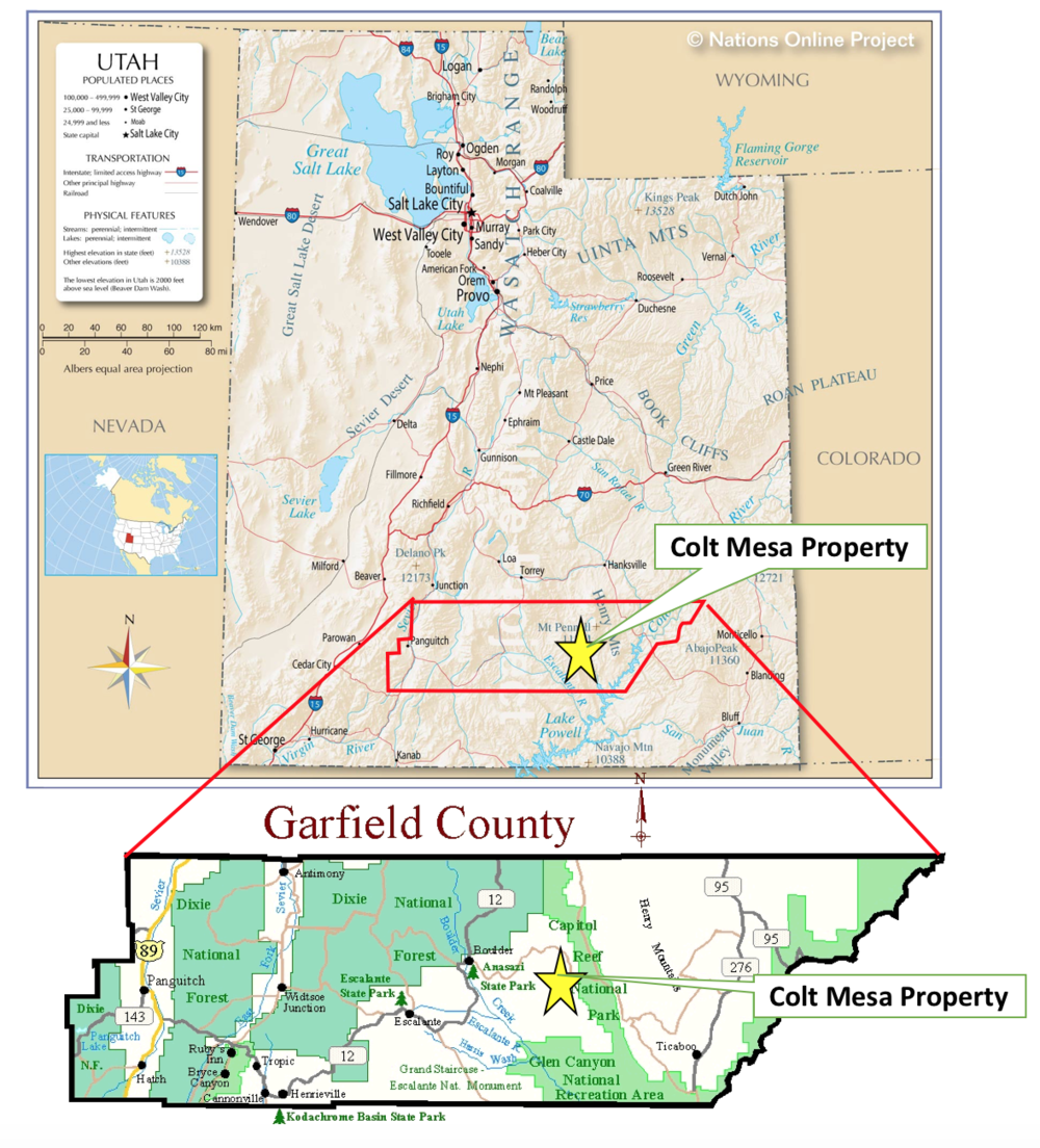
CLIENT FEATURE: Glacier Lakes ( GLI.V ) Colt Mesa Property – Past Producing Mine Samples 2.31% Cobalt

Posted by AGORACOM at 11:45 AM on Friday, January 25th, 2019

GLI:TSX

  • Property covers the past producing Colt Mesa Mine, a copper deposit with associated cobalt, zinc, nickel and molybdenum mineralization.
  • Recent sampling (CM-18-01) returned values of 0.88(%) copper (Cu), 2.31% cobalt (Co), 9.31 % zinc (Zn), +1.00 % nickel (Ni), and 0.29 % molybdenum (Mo), over a 0.3 meter chip sample of surface exposure near the adit portal.
  • Area recently became open for staking and exploration after a 21 year period moratorium, due to the reduction of the “Grand Staircase Escalante National Monument” by President Trump in December 2017.
  • 1975 grab sampling reported values from 0.07% to 29.50 % copper (Cu), 0.01% to 0.67 % cobalt (Co), 0.03% to 3.30 % zinc (Zn), 0.02% to 0.27 % nickel (Ni), and trace to 0.17 % molybdenum (Mo). The Company cautions investors grab samples are selected samples and are not necessarily representative of the mineralization on the Colt Mesa property.
  • Sedimentary (sandstone) hosted, tabular strata-bound mineralization.
  • Excellent year-round logistics, road accessible. No reclamation issues from historic mining activity.

https://static1.squarespace.com/static/5b0755ac365f02104c1b9097/t/5b1eef0770a6adf11579f3d7/1531171143346/Screen+Shot+2018-06-11+at+2.13.56+PM.png

Hub on AGORACOM 

Corporate Profile

FULL DISCLOSURE: Glacier Lake Resources is an advertising client of AGORA Internet Relations Corp.

$NSM.ca Northern Sphere Mining Corp. announces Arizona Gold Processing Agreement with New Ruby Mining Corp.

Posted by AGORACOM at 8:40 AM on Tuesday, September 11th, 2018

https://s3.amazonaws.com/s3.agoracom.com/public/companies/logos/564605/hub/NSM.png

  • Entered into a gold processing agreement with New Ruby Mining Corp.
  • The initial production run of gold mineralized material is scheduled to occur during the fourth quarter of 2018.
  • NSM will make payment to New Ruby for the gold mineralized material based on a 50/50 net profit share arrangement.

Toronto, Ontario–(Newsfile Corp. – September 11, 2018) – Northern Sphere Mining Corp. (CSE: NSM) (OTCQB: NSMCF) (“NSM” or the “Company”) is pleased to announce it has entered into a gold processing agreement with New Ruby Mining Corp. (“New Ruby”) pursuant to which the Company has agreed to process up to 100 tons per day of high grade gold mineralized material from New Ruby’s Houdon/Ellison gold property (the “Property”), located 80 miles north of NSM’s Globe Arizona production facility.

The processing by NSM will consist of crushing, grinding, screening, gravity concentration and pouring of gold dore bars. New Ruby has agreed to deliver the gold mineralized material to the NSM production facility in batches. The Company will store the mineralized material until sufficient tonnage is received for a production run. Tailings will be returned to the Property as backhaul loads as milling is completed. Gold dore bars will be sold by NSM directly to the refinery.

NSM will provide all of the management and accounting support in connection with these arrangements, including the collection of payment for the sale of gold dore bars. Following receipt of payment on the sale of gold dore bars, NSM will make payment to New Ruby for the gold mineralized material based on a 50/50 net profit share arrangement.

The initial production run of gold mineralized material is scheduled to occur during the fourth quarter of 2018. Metallurgical testing will commence immediately upon receipt of a 500 lbs sample of gold mineralized material from New Ruby. NSM’s production facility includes full gravity processing, an assay facility, maintenance shop and office.

“We are pleased that the Company will be in position to start generating revenue that will be used to advance our other assets,” stated A. John Carter, Chief Executive Officer. “Specifically, we will be focusing on our copper/silver/gold/manganese anomaly in Arizona (approximately 3 miles from the Buckeye Mine) and our gold/copper/cobalt/platinum group metals property in Northern Ontario.”

About Northern Sphere Mining Corp.

Northern Sphere is dedicated to growth through the acquisition and development of mining assets with an emphasis on gold, silver and copper. In efforts to expedite and optimize mineral targeting on its assets, the Company is employing cutting-edge exploration technologies to generate robust mining projects. Headquartered in Toronto, Ontario, Northern Sphere has a strong project pipeline of properties with a focus on gold, silver and other metal production in pro-mining jurisdictions.

Cautionary Statements

This press release contains forward-looking statements which reflect Northern Sphere’s current expectations regarding future events. The forward-looking statements involve risks and uncertainties. Actual results could differ materially from those projected herein. Northern Sphere disclaims any obligation to update these forward-looking statements other than as required by applicable securities laws.

For further information, please contact:
A. John Carter
Chief Executive Officer
Northern Sphere Mining Corp.
Tel: 905-302-3843

$GR.ca Great Atlantic has Begun 2018 Exploration Drilling Program at its Pilley’s Island Base – Precious Metal Property Northern Newfoundland $LAB.ca, $ANX.ca $MOZ.ca

Posted by AGORACOM at 9:20 AM on Thursday, September 6th, 2018

https://s3.amazonaws.com/s3.agoracom.com/public/companies/logos/564603/hub/GREATATLANTIC_LOGO_TESTER-e1480712241913.jpg

  • Commenced the 2018 exploration at its Pilley’s Island Base – Precious Metal Property, Newfoundland
  • program consists of prospecting and rock and soil geochemical sampling on a regional scale, multiple targets
  • Significant levels of zinc, lead, copper, gold and silver identified in 2017 at the Bull Road Showing

Vancouver, British Columbia (FSCwire)GREAT ATLANTIC RESOURCES CORP. (TSXV.GR) (the “Company” or “Great Atlantic”) is pleased to announce it has commenced the 2018 exploration program at its Pilley’s Island Base – Precious Metal Property, located in north-central Newfoundland, Newfoundland and Labrador. The property was expanded in 2018 to 4,600 hectares, covering most of Pilley’s Island. The current work program consists of prospecting and rock and soil geochemical sampling on a regional scale covering multiple target areas. The Company confirmed significant levels of zinc, lead, copper, gold and silver mineralization during 2017 within the property at the Bull Road Showing. The Company is also planning a diamond drilling program for 2018 at the Bull Road Showing.


To view the graphic in its original size, please click here

The focus of Great Atlantic’s work to date on the property has been the Bull Road showing, located in the southern region of Pilley’s Island. A trench was excavated in 2017 at this showing exposing sulfide mineralization over a northwest-southeast length of 130 meters with a width varying between 1-7 meters. The Bull Road Showing is a polylithic slump breccia of volcanogenic massive sulphide mineralization containing massive sulphide clasts up to greater than a meter in length. Sample results from this trench are reported in the Company’s News Releases of November 16 and December 14, 2017. Bull Road Trench sample highlights include (channel sample lengths are in meters):

  • 1.05m channel sample: 15.40% Zn, 6.60% Pb, 4.66% Cu, 111.5 g/t Ag and 1.008 g/t Au.


  • 0.70m channel sample: 17.30% Zn, 0.10% Pb, 2.97% Cu, 31.2 g/t Ag and 0.449 g/t Au.


  • 0.95m channel sample: 3.95% Zn, 0.73% Pb, 2.83% Cu, 62.2 g/t Ag and 0.613 g/t Au.


  • 1.00m channel sample: 2.96% Zn, 0.03% Pb, 3.27% Cu, 30.4 g/t Ag and 0.563 g/t Au


  • Outcrop grab sample: 40.8% Zn, 4.69% Pb, 6.08% Cu, 22.5 g/t Ag and 1.366 g/t Au.


  • Outcrop grab sample: 32.60% Zn, 1.30% Pb, 8.38% Cu, 148.1 g/t Ag and 1.421 g/t Au


  • Outcrop grab sample: 36.40% Zn, 5.50% Pb, 4.22% Cu, 59.9 g/t Ag and 0.325 g/t Au


  • Outcrop grab sample: 27.5% Zn, 20.0% Pb, 5.78% Cu, 63.4 g/t Ag and 0.314 g/t Au


Bull Road Trench

To view the graphic in its original size, please click here


Massive sulfide mineralization at the Bull Road Trench

To view the graphic in its original size, please click here

The 2017 samples were analyzed at Eastern Analytical in Springdale Newfoundland (gold by Fire Assay – atomic absorption (AA); and copper, lead, zinc and silver by multi-acid digestion and AA). The channels samples were collected across selected clasts at generally right angles to the long dimension of the clasts.  The 2017 Bull Road trench sample data was verified by qualified persons who managed the sampling program and verified sample data.

Great Atlantic is planning a diamond drilling program for fall 2018 at the Bull Road showing.

The Pilley’s Island Property hosts the historic Pilley’s Island Mine, which operated during the 1890s and early 1900s. The Newfoundland and Labrador Department of Natural Resources reports historic estimated proven reserves of 1.159 million tonnes grading 1.23% Cu (referencing Grimley, 1968 as the source) or 627,373 tons at 2.34% Cu (referencing Walker, 1976 as the source ) in their Mineral Occurrence Database. David Martin, VP Exploration for Great Atlantic, states “These historical estimates of reserves are not reliable. The historical estimates are only relevant to the extent of identifying an area on the property for research and possible future exploration. The key assumptions, parameters, and methods used to prepare the historical estimates are not known.  A qualified person has not done sufficient work to classify the historical estimates as current resources or current reserves. A qualified person would need to complete sufficient work following CIM Best Practice Guidelines to upgrade or verify the historical estimates as current mineral resources or mineral reserves. This would almost certainly require additional exploration in the way of diamond drilling, trenching and / or underground work and corresponding sampling all of which must follow CIM Exploration Best Practice Guidelines.” Great Atlantic is not treating the historical estimates for the historic Pilley’s Island Mine as current mineral resources or mineral reserves.

Access to and infrastructure at the Pilley’s Island Property is excellent. The property is serviced with power mains and government maintained roads and is within 2 km of tide water. The property is located within a mining friendly district.

Readers are warned that historical data on the historic Pilley’s Island Mine referred to in this News Release have not been verified by a qualified person. A qualified person has not verified this data as the Company’s focus since acquiring the property in 2017 has been the Bull Road showing.

David Martin, P.Geo., a Qualified Person as defined by NI 43-101 and VP Exploration for Great Atlantic, is responsible for the technical information contained in this News Release.

On Behalf of the board of directors

“Christopher R Anderson”

Mr. Christopher R Anderson  ” Always be positive, strive for solutions, and never give up ”

President CEO Director

604-488-3900

[email protected]


$GLI.ca Glacier Lake Completes Exploration at Silver Vista and Hackett Properties $TUE.ca

Posted by AGORACOM at 9:29 AM on Tuesday, September 4th, 2018

https://s3.amazonaws.com/s3.agoracom.com/public/companies/logos/564613/hub/GlacierLake.png

  • Glacier Lake Resources Inc. completed 2 reconnaissance surface exploration programs on its Silver Vista and Hackett properties
  • Silver Vista, the company’s principal project,  is a large, bulk-tonnage, clastic-sediment-hosted, disseminated copper-silver deposit
  • SV18-06 returned 153.4 meters averaging 28.9 grams per tonne silver equivalent

EXPLORATION ACTIVITY UPDATE- SILVER VISTA AND HACKETT PROPERTIES

Glacier Lake Resources Inc. has completed two reconnaissance surface exploration programs on its Silver Vista and Hackett properties. The Silver Vista property is the company’s principal project and is located near Smithers, B.C., with a focus on the discovery of a large, bulk-tonnage, clastic-sediment-hosted, disseminated copper-silver deposit. The Hackett property is located in the Sheslay area of northwestern British Columbia, strategically adjoins the eastern border of the Hat property, owned by Doubleview Capital Corp. and actively being explored by Hudbay Minerals Inc., the company’s joint venture partner. The work on both properties was completed by Exploration Facilitation Unlimited Inc.

Silver Vista property

The “MR Zone” on the Silver Vista property was drilled in the 1st quarter of 2018, with seven holes, totalling 1,273 metres completed. All drilling was directed at the “MR Zone”, which represented the first drilling on the property since the initial program of 1,252.5 meters in 1991/1992. Highlights of the recent drill program include Hole SV18-06 which returned multiple horizons of mineralization over the entire length of the hole, with the entire drill hole length of 153.4 meters averaging 28.9 grams per tonne silver equivalent, (see press release May 23, 2018). Hole SV18-06 was the northernmost hole and the mineralized zone is open and undrilled to the west, north and northwest. Assay results from these two work programs are pending.

The “MR Zone” discovery (1990) comprises a mineralized showing in a logging road-cut. The property has been extensively logged recently, and a network of newly constructed roads was the focus of this summer exploration program to discover additional mineralization in outcrop exposures or boulders.

Work performed included till sampling using a backpack drill and prospecting/mapping. A total of 7 till samples and 25 rock grab samples were collected from three target areas (West, SE, Circle Road), away from the “MR Zone’ area. Outcrop exposure is limited, due to the slight, rolling topography, but weak observations of copper mineralization (oxide stain) were observed at all three locations. The West and SE Target areas were surveyed using a GDD Beep Mat to detect near-surface EM/Mag conductors, with one anomaly noted. Further details on the Silver Vista property can be found in the National Instrument 43-101 report on the property located under the company’s SEDAR profile.

Hackett property

The Hackett property is located approximately 38 kilometres northwest of the village of Telegraph Creek, and approximately 95 kilometres west-southwest of Dease Lake. The western border of the Hackett property is less than a kilometre away from Doubleview’s Lisle zone, and the Hoey Minfile prospect is located near Big Creek on the boundary with the Hat property. Exploration activity focused on expanding on the mineral showings discovered in 2014, related to the Hoey Minfile occurrence, which lies on the boundary with Doubleview. On the Hackett property the 2014 discovery mineral showing returned 24 and 594 parts per billion gold, and 598 and 2,970 parts per million copper, respectively. Approximately 150 m upstream on Big Creek from the discovery showing, another strongly oxidized showing returned 128 ppb gold and 935 ppm copper.

ing, with a crew using a fly-camp located on the property, serviced by helicopter form Dease Lake. In total 26 rock samples were collected from the area of the 2014 sampling in a steep ravine on the western flank of the property. The majority of samples collected were gossanous fine-grained mafic volcanics, many of which contained quartz -carbonate veins/veinlets. In addition, 33 soil samples were collected using augers from within a target zone projects as the extension of the Hoey Zone.

The technical content of this news release has been reviewed and approved by R. Tim Henneberry, PGeo, a member of the Glacier Lake advisory board and a qualified person as defined by National Instrument 43-101 — Standards of Disclosure for Mineral Projects.

The TSX Venture Exchange has accepted for filing the company’s issuance of 734,095 shares at an average price of $0.0725 in consideration of certain services provided to the company pursuant to an agreement dated May 25, 2017.

$GLI.ca Maiden Drilling at Silver Vista Supports a Large Mineralized System $JAX.ca $TUE.ca

Posted by AGORACOM at 2:57 PM on Friday, August 3rd, 2018


https://s3.amazonaws.com/s3.agoracom.com/public/companies/logos/564613/hub/GlacierLake.png

GLI:TSX.V

  • Recently completed maiden drill program on its Silver Vista property located near Smithers, B.C.
  • Significant silver-copper mineralization  intersected in all seven holes.
  • Hole SV18-06 returned multiple horizons of mineralization over the entire length of the hole, with the 153.4-metre length averaging 28.9 grams per tonne silver equivalent, comprising 16.1 grams per tonne silver, 0.05 per cent copper and 0.10 per cent zinc.
  • Geology, geophysics, and exploration on Silver Vista indicate potential for world class deposit.

“Results from our maiden drill program on the Silver Vista MR target support a large mineralizing system, with excellent potential to expand the silver-copper zones to the northwest and west,” said Saf Dhillon,


FULL DISCLOSURE: Glacier Lake Resources is an advertising client of AGORA Internet Relations Corp.

Hub on AGORACOM 

Corporate Profile

$GLI.ca Acquisition of Colt Mesa Copper-Cobalt Property, Utah, Surface Grab Samples Return 0.88% Copper and 2.31% Cobalt $JAX.ca

Posted by AGORACOM at 8:31 AM on Wednesday, June 13th, 2018

https://s3.amazonaws.com/s3.agoracom.com/public/companies/logos/564613/hub/GlacierLake.png

  • Announced the acquisition of the “Colt Mesa” copper-cobalt property in Garfield County, south central Utah.
  • Colt Mesa mine is associated cobalt, zinc, nickel and molybdenum mineralization
  • Recent sampling (CM-18-01) by Company personnel, on a site visit with the vendor of the property, returned values of 0.88 percent (%) copper (Cu), 2.31% cobalt (Co), 9.31 % zinc (Zn), +1.00 % nickel (Ni), and 0.29 % molybdenum (Mo), over a 0.3 meter chip sample of surface exposure near the adit portal


VANCOUVER, British Columbia, June 13, 2018 (GLOBE NEWSWIRE) — Glacier Lake Resources Inc. (TSXV:GLI) – (“Glacier” or the “Company”) is pleased to announce the acquisition of the “Colt Mesa” copper-cobalt property in Garfield County, southcentral Utah. The property is readily accessible by gravel roads from Boulder, the closest community with services and support. Key takeaways:

  • Property covers the past producing Colt Mesa mine, a copper deposit with associated cobalt, zinc, nickel and molybdenum mineralization.
  • Recent sampling (CM-18-01) by Company personnel, on a site visit with the vendor of the property, returned values of 0.88 percent (%) copper (Cu), 2.31% cobalt (Co), 9.31 % zinc (Zn), +1.00 % nickel (Ni), and 0.29 % molybdenum (Mo), over a 0.3 meter chip sample of surface exposure near the adit portal. Tables below,
  • Area recently became open for staking and exploration after a 21 year period moratorium, due to the reduction of the “Grand Staircase Escalante National Monument” by President Trump in December 2017.
  • 1975 grab sampling reported values from 0.07% to 29.50 % copper (Cu), 0.01% to 0.67 % cobalt (Co), 0.03% to 3.30 % zinc (Zn), 0.02% to 0.27 % nickel (Ni), and trace to 0.17 % molybdenum (Mo). The Company cautions investors grab samples are selected samples and are not necessarily representative of the mineralization on the Colt Mesa property.
  • Sedimentary (sandstone) hosted, tabular strata-bound mineralization.
  • Excellent year-round logistics, road accessible. No reclamation issues from historic mining activity.

“The Colt Mesa acquisition broadens our focus on sedimentary hosted copper deposits, with a significant bonus of cobalt and nickel mineralization indicated. There is strong investor interest in the “Battery Metals” sector, including cobalt, nickel and copper. With this new interest coupled with the growth of the EV sector and strong demand for cobalt, the Colt Mesa project is a welcome addition to the Company’s ever growing portfolio of projects,” says Saf Dhillon, president and chief executive officer. “Surface exploration work will start this summer on the Colt Mesa property and drill permitting will be initiated shortly.”

The Colt Mesa deposit was discovered in 1968 and was mined intermittently from 1971 to 1974. While little data survived from the copper mining activities, a 1975 Master Thesis (G.M. Collings, 1975, Geology and Geochemistry of the Colt Mesa Copper Deposit”) completed at the University of Utah, is an invaluable source of information on the geology and mineralization at the Colt Mesa mine.

Tabular, strata-bound copper mineralization lies within a paleochannel at the contact of two distinct sedimentary (sandstone) units. The trackless, room-and-pillar mining was focused on the copper mineralization meaning the mine and surrounding area were never systematically explored for cobalt mineralization.

All of the above samples were taken at surface, near the adits. The underground working was examined (see website for photos), but not sampled. Samples CM-18-01, 02, and 03, were chip sampled from the same location over a width of 1.35 meters, averaging 0.52 % Cu, 1.51 % Co, 6.52 % Zn, 0.79% Pb, and 0.17 % Mo. Sample CM-18-01 and CM-18-03 had conspicuous “cobalt bloom”, whereas CM-18-02 was barren, unmineralized sandstone. Sample CM-18-04 was a select grab sample of bright, copper oxide float from the dump. The Colt Mesa is renowned for brilliant, multicolored copper oxides, attributed to the association with cobalt and molybdenum.’

The 1975 Master Thesis reports: “The ore body is tabular in form and is composed of chalcopyrite, bornite, digenite, covellite and chalcocite”. Sampling of the underground mineralized zone was completed in 1975 with a total of eight samples from the mineralized zone taken as follows:

Again, the Company cautions investors grab samples are selected samples and are not necessarily representative of the mineralization on the Colt Mesa property.

The Colt Mesa area has seen significant exploration for uranium in the 1950s and 1960s, modest exploration for copper and base metals but minimal exploration was focused on cobalt and nickel. The Colt Mesa mine area was sterilized from exploration and development in 1996, when President Clinton created the “Grand Staircase Escalante National Monument”, however, the size was recently reduced by Presidential proclamation in 2017, placing Colt Mesa outside the new boundaries of the restructured national monument.

For more information on the Colt Mesa project go to https://www.glacierlake.ca/colt-mesa/

In consideration for the property, Glacier Lake will issue one million common shares, and make a cash payment of US $120,000, staged over a two (2) year period. The vendors retain a one-and-three-quarters percent (1.75%) Net Smelter Returns (“NSR”). Glacier shall be entitled to purchase one percent (1.00%) of the Royalty at any time through a one-time cash payment of $1,000,000 to the vendors. Completion of the acquisition is subject to the approval of the TSX Venture Exchange. All common shares issued will be subject to a four-month-and-one-day statutory hold period. A finder’s fee may be payable related to this acquisition.

Quality assurance/quality control

All recent surface samples from the Colt Mesa property were hand delivered to the ALS Minerals Ltd. North Vancouver, B.C., laboratory, an 17025:2005 certified facility. All samples were collected by Company personnel and securely stored until delivery to ALS Minerals. At this early stage of exploration, Glacier Lake is relying on the certified standards utilized by ALS Minerals as part of it analysis protocols. No QA/QC anomalies were noted in the analyses.

The technical content of this news release has been reviewed and approved by R. Tim Henneberry, P.Geo, a member of the Glacier Lake advisory board and a qualified person as defined by National Instrument 43-101 — Standards of Disclosure for Mineral Projects.
For additional information please feel free to contact:

Saf Dhillon
President/CEO
Glacier Lake Resources Inc.
Tel:866-687-7059
Dir: 604-688-2922
[email protected]

Please visit our Website at: www.glacierlake.ca