Agoracom Blog Home

Posts Tagged ‘#Discovery’

GGX Gold Intersects 129 G/T Gold and 1,154 G/T Silver over 7.28 Meters Diamond Drilling Program at COD Vein $GGX.ca $TUSK.ca $GZD.ca

Posted by AGORACOM at 8:16 AM on Tuesday, January 15th, 2019
https://s3.amazonaws.com/s3.agoracom.com/public/companies/logos/564602/hub/ggx_large.png
  • 129 g/t gold and 1,154 g/t silver over 7.28 meter core length (majority of samples greater than the upper 500 g/t analytical limit for tellurium).
  • High-grade quartz vein intersection is near-surface (18 to 23 meters vertical depth).
  • Part of exploratory shallow drilling designed to define high-grade mineralization and expand the understanding of controls on mineralization.
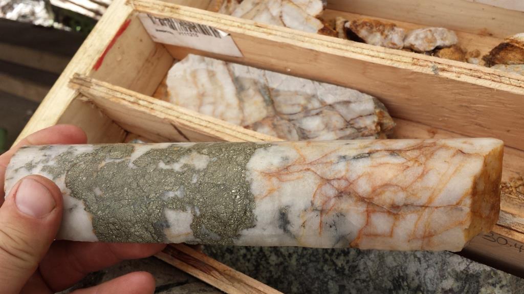
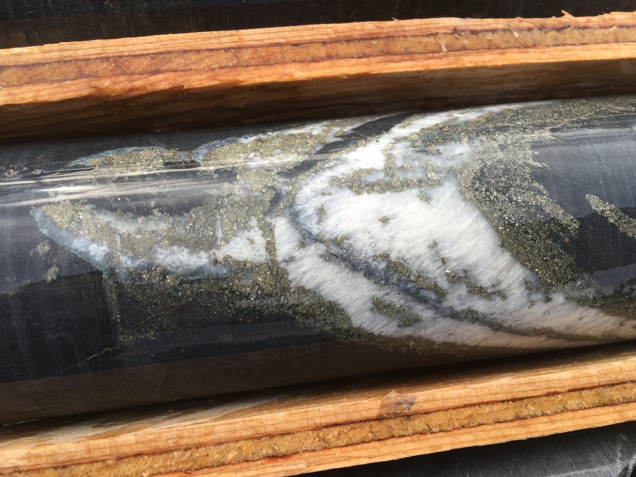
  • Telluride mineralization is common in vein intersection. Visible gold in one section.

VANCOUVER, BC / ACCESSWIRE / January 11, 2019 / GGX Gold Corp. (TSX-v: GGX), (OTCQB: GGXXF), (FRA: 3SR2) (the “Company” or “GGX“) is pleased to announce it has received drill core analytical results for drill holes COD18-65 to COD18-67 completed during the November 2018 diamond drilling program at its Gold Drop Property near Greenwood, southern British Columbia. COD18-67 intersected near-surface high-grade gold and silver with significant tellurium in the COD quartz vein. COD18-67 tested the southwest region of the COD vein in an area of prior high-grade gold drill intercepts. The mineralized COD vein system has been traced by drilling and / or trenching for approximately 400 meter strike length and is open to the northeast, at depth and possibly to the southwest. Highlights for COD18-67 include:

The November 2018 diamond drilling program (11 drill holes: COD18-61 to COD18-71) tested the southwest region of the COD vein in an area of high-grade gold and silver mineralization. The COD vein is located in the Gold Drop Southwest Zone. Prior 2018 drill holes in this part of the COD vein intersected near-surface high-grade gold and silver mineralization (News Releases of August 15 and 22, 2018). These include (core length):

  • COD18-45: 50.1 g/t gold and 375 g/t silver over 2.05 meters

(including 167.5 g/t gold, 1,370 g/t silver & >500 g/t tellurium over 0.46 meters).

  • COD18-46: 54.9 g/t gold and 379 g/t silver over 1.47 meters

(including 223 g/t gold, 1,535 g/t silver & > 500 g/t tellurium over a 0.30 meters).

  • Approximate 20 meter (COD18-45) to 23 meter (COD18-46) vertical depth of high grade gold and silver mineralization.

Drill holes COD18-45 and COD18-46 were drilled at 45 and 50 degree dips to the west from the same site to intersect the northeast-southwest striking COD vein.

Intersections exceeding 1 g/t gold for drill holes COD18-65 to COD18-67 are listed in the table below. Since true widths cannot be accurately determined from the information available the core lengths (meters) are reported.

Hole ID From (m) To (m) Length (m) Au (g/t) Ag (g/t) Te (g/t) Description
COD18-66 16.35 16.75 0.40 1.02 6.22 3.46 Quartz veinlet & altered wall rock.
COD18-66 22.96 23.90 0.94 6.97 46.8 34.4 Quartz vein
COD18-67 23.19 30.47 7.28 129.1 1,154.9 Quartz vein with +/- tellurides
COD18-67 incl. 23.58 23.95 0.37 106 1250 >500 Quartz vein with tellurides & VG
COD18-67 incl. 24.50 27.63 3.13 232.1 2,001.1 >500 Quartz vein with +/- tellurides
COD18-67 incl. 29.70 30.47 0.77 143 1,372.9 >500 Quartz vein with tellurides

Samples of felsic intrusive wall rock adjacent to the high grade vein in COD18-67 returned low grade gold values of 0.77 g/t (22.00-23.19 meters) and 0.57 g/t (30.47-32.72 meters).

All of the November 2018 drill holes were collared within 25 meters of holes COD18-45 and COD-46, the objective to define the high-grade mineralization in this part of the COD vein and to provide information on the controls on mineralization. Holes COD18-61 to COD18-66 were drilled to the west and slightly northwest at dips of 45 to 60 degrees to intersect the approximately northeast striking vein(s). Holes COD18-67 to COD18-71 were drilled at dips of 45 to 60 degrees slightly northeast to intersect the vein(s) at a shallower angle, the objective being to test the continuity of the quartz veining and mineralization.

Analytical results for drill holes COD18-61 to COD18-64 were reported in the Company’s News Release of January 9, 2018, the highlight being an intersection of 28.0 g/t gold, 424.7 g/t silver and 150.4 g/t tellurium over 1.17 meter core length in COD18-63.

The drill core was split with half core samples securely packaged and delivered to ALS Canada Ltd. in Vancouver, BC. The core samples were analyzed for gold by Fire Assay-Atomic Absorption and for 48 elements (including silver and tellurium) by Four Acid – ICP-MS. Samples exceeding 100 g/t gold were re-analyzed for gold by Fire Assay – Gravimetric Finish. Samples exceeding 100 g/t silver were re-analyzed for silver by Four Acid – ICP-AES. Samples exceeding 1,500 g/t silver by Four Acid – ICP-AES were re-analyzed for silver by Fire Assay – Gravimetric Finish. Quality control (QC) samples were inserted at regular intervals.

Gold and silver bearing quartz veins occur in multiple regions on the property with high grade gold reported (samples exceeding 1 oz. / ton gold reported).

Historic gold and silver production occurred at the Gold Drop, North Star, Amandy and Roderick Dhu vein systems.

David Martin, P.Geo., a Qualified Person as defined by NI 43-101, is responsible for the technical information contained in this News Release.

“With each additional drill program, we are significantly improving the gold grade mineralization of the COD Vein. We continue to expand the known strike length of the mineralized vein system, which remains open in several directions. With another new near-surface high-grade gold-zone and increasing strike length, we are very satisfied with the results generated and optimistic on the gold potential of the Gold Drop project.” comments Barry Brown, President.

On Behalf of the Board of Directors,
Barry Brown, Director
604-488-3900
[email protected]

$AAX.ca Advance Gold Update On Exploration Plans

Posted by AGORACOM at 1:31 PM on Thursday, December 6th, 2018

https://s3.amazonaws.com/s3.agoracom.com/public/companies/logos/564631/hub/advance-gold-large.png

  • Phase 2 identified 30 epithermal veins that remain open at depth and along strike
  • 1000m to the northeast lies the SG3 target area,  which is a feeder system type target.
  • Plan to drill deeper into the vein system to look for the boiling point in epithermal veins

Vancouver, British Columbia–(Newsfile Corp. – December 6, 2018) – Advance Gold Corp. (TSXV: AAX) (“Advance Gold” or “the Company”) is pleased to provide an update on exploration plans for its Tabasquena project near Ojocaliente, Mexico. Based on the phase 2 drilling program, and historical work completed by the geological survey of Mexico, a dual track drilling program is being planned.

The recently completed drilling in phase 2, has identified a series of epithermal veins (more than 30), which have only been drilled above the boiling point and remain open at depth and along strike. Approximately 1000 metres to the northeast, the SG3 target area, is a structural intersection mapped and sampled by the geological survey of Mexico which is a feeder system type target.

Allan Barry Laboucan, President and CEO of Advance Gold Corp. commented: “Now that we have established that there is a large cluster of epithermal veins at Tabasquena, we are also eager to explore for feeder system type targets. Our plan to drill deeper into the vein system to look for the boiling point in our epithermal veins, combined with stepping out into other areas of the property gives us a good chance to open things up.

“Past work by the geological survey of Mexico, at the SG3 target area, has mapped a key structural intersection to the northeast of the vein system and a coincident gold anomaly.

“The more work we do on the property, the more it becomes clear that we are looking at a large epithermal vein system, and other compelling targets on the project. We are looking forward to more drilling to test these targets in our phase 3 drilling.”

Julio Pinto Linares is a QP, Doctor in Geological Sciences with specialty in Economic Geology and Qualified Professional No. 01365 by MMSA., for Advance Gold and is the qualified person as defined by National Instrument 43-101 responsible for the accuracy of technical information contained in this news release.

Other News

The Company is cancelling the previously announced, see November 2/2018 news release, private placement. It proposes to undertake a non-brokered private placement of units at a price of $0.06 (6 cents) per unit for gross proceeds of up to $300,000. Each unit shall consist of one common share in the capital of the company and one common share purchase warrant.

Each warrant shall entitle the holder to purchase one common share at a price of $0.08 (8 cents) per share at any time within 24 months of the date of issuance. All securities to be issued under this private placement will be subject to a four-month resale restriction.

The company intends to close the private placement immediately following the satisfaction of customary closing conditions, including receipt of all regulatory approvals. There are no material facts or material changes relating to the company that have not been previously disclosed.

Advance Gold will use the net proceeds of this private placement for general corporate purposes and to advance its Tabasquena silver project in Zacatecas, Mexico.

About Advance Gold Corp. (TSXV: AAX)

Advance Gold is a TSX-V listed junior exploration company focused on acquiring and exploring mineral properties containing precious metals. The Company acquired a 100% interest in the Tabasquena Silver Mine in Zacatecas, Mexico in 2017, and the Venaditas project, also in Zacatecas state, in April, 2018.

The Tabasquena project is located near the Milagros silver mine near the city of Ojocaliente, Mexico. Benefits at Tabasquena include road access to the claims, power to the claims, a 100-metre underground shaft and underground workings, plus it is a fully permitted mine.

Venaditas is well located adjacent to Teck’s San Nicholas mine, a VMS deposit, and it is approximately 11km to the east of the Tabasquena project, along a paved road.

In addition, Advance Gold holds a 14.5% interest on strategic claims in the Liranda Corridor in Kenya, East Africa. The remaining 85.5% of the Kakamega project is held by Acacia Mining (63% owned by Barrick Gold).

For further information, please contact:
Allan Barry Laboucan,
President and CEO
Phone: (604) 505-4753
Email: [email protected]

Corporate website: www.advancegold.ca

CLIENT FEATURE: Labrador Gold’s Shaw Ryan Targeting the Under Explored Gold Potential of the Province $MOZ.ca $SIC.ca $GR.ca

Posted by AGORACOM at 2:24 PM on Tuesday, December 4th, 2018

https://s3.amazonaws.com/s3.agoracom.com/public/companies/logos/564640/hub/Small-Logo-Labrador-GOLD.jpg

    • Led by Shawn Ryan, who’s prospecting and soil geochemistry work led to the discovery of  White Gold, Coffee, and QV projects for a total of 7.5M ounces Au
    • White Gold’s geochemical sampling program led to successful drill program
    • Exploration has already outlined district scale soil anomalies on two projects in Labrador
    • Hopedale property contains the Florence Lake greenstone belt and the Hunt River, both of which are under-explored for gold
    • Florence Lake greenstone belt has a 40 KM strike length and includes Thurber Dog
    •  Preliminary soil geochemical results show arsenic anomalies in several areas
    • Arsenic is a pathfinder element when exploring for gold


LAB Agoracom Hub

FULL DISCLOSURE: Labrador Gold is an advertising client of AGORA Internet Relations Corp.

$AMK.ca American Creek Reports JV Partner Intersects 0.98 g/t Gold Over 563.8M At Treaty Creek Property in the Golden Triangle $TUE.ca, $MK.ca

Posted by AGORACOM at 9:38 AM on Monday, November 26th, 2018

https://s3.amazonaws.com/s3.agoracom.com/public/companies/logos/562696/hub/HubLogoLarge2_copy.jpg

  • Final hole (CB-18-39) of the 2018 exploration season,was a 90 m step-out to the north of the Copper Belle Zone
  • Intersected 0.981 g/t gold over 563.8m, including 1.15 g/t gold over 234 m and 1.72 g/t gold over 55.5m
  • Widest and most strongly mineralized interval of the 69 holes that have been drilled within the zone

Cardston, Alberta–(Newsfile Corp. – November 26, 2018) –  American Creek Resources Ltd. (TSXV: AMK) (“American Creek”) (“the Corporation”) is pleased to report that the final hole (CB-18-39) of the 2018 exploration season, a 90 m step-out to the north of the Copper Belle Zone, intersected 0.981 g/t gold over 563.8 meters including 1.15 g/t gold over 234 m and 1.72 g/t gold over 55.5m and bottomed in mineralization. This is the widest and most strongly mineralized interval seen to date of the 69 holes that have been drilled within the zone, and more importantly, suggests potentially greater widths of mineralization continuing to the north and northeast. This new extension will be a prime target for follow-up drilling in 2019.

Hole CB-18-39 is one of the three holes reported here that were part of the nine-hole 2018 drill program on the Copper Belle zone of the Company’s Treaty Creek property, in the “Golden Triangle” area of north-western BC (see map below). The Treaty Creek property is adjacent to and part of the same large hydrothermal system as Seabridge’s KSM property and Pretivm’s Brucejack / Snowfield property. Results of core sampling have now been received for all of the nine holes completed. The first six holes were reported in the August 24 and October 30 news releases.

Walter Storm, President and CEO, stated: “This very positive intersection in the final hole of the year at Treaty Creek exhibits particularly strong gold values for a porphyry-style deposit. It is certainly the best result to date at Copper Belle – in terms of grade x length – being some 50% longer than the previous longest intersection. We drilled 9 deep holes in 2018, testing a large area with a wide-spaced drill pattern, a program which has expanded the Copper Belle zone to the north and northwest; discovering broad intercepts of gold mineralization adjacent to similar wide intercepts reported in 2017. The target next year will be more drilling north and northeast of Hole CB-18-39, expanding on the significant grade and scale of the gold mineralization encountered.”

Copper Belle Drill Hole CB-18-39 Mineralized Intervals

Hole ID From (m) To (m) Interval (m) Au (g/t) Ag (g/t) Cu (ppm)
CB-18-39 141.5 705.3 563.8 0.981 4.4 352.2
includes 141.5 185 43.5 1.21 2.8 171.7
and 194 428 234 1.147 6.1 501.6
and 437 474.5 37.5 0.352 2.8 84
and 483.5 519.5 36 0.641 2.1 282.4
and 530 549.5 19.5 1.071 1.8 407.7
and 560 563 3 1.243 1 167.5
and 569 624.5 55.5 1.719 10.4 348.3
and 632 660.5 28.5 1.521 2.4 330.9
and 666.5 705.3 38.8 0.673 1.5 305.1
EOH 705.3


* All assay values are uncut and intervals reflect drilled intercept lengths.
* True widths of the mineralization have not been determined.

CB-18-39 intersected mineralization from a depth of 141.5 m to the end of the hole at 705.3 m, averaging 0.981 g/t Au over 563.8 m. The hole also contained higher grade sections, such as 1.719 g/t Au, with 10.4 g/t Ag, over 55.5 m and, significantly, the hole ended in mineralization, grading 0.673 g/t Au over 38.8 m, indicating potential for continuing mineralization at depth.

CB-18-39 was drilled northwesterly at an angle of -72 degrees. The host volcaniclastic rocks are typically chlorite, sericite and locally potassically altered, however the more strongly mineralized intervals exhibit increased pyrite and stronger silicification than surrounding rocks. This hole also displayed more chalcopyrite than was observed in previous holes. This may indicate that copper grades could be increasing to the north. Silver values were also higher on average in hole CB-18-39, with sections such as 10.4 g/t Ag over 55.5 m from 569.0 m to 624.5 m.

Hole CB-18-39 is the northernmost hole drilled to date and has extended the length of the Copper Belle Zone approximately 90 m northeast from CB-18-37B, to a total known length of 1200 m. Hole CB-18-38; a fill-in hole in the east part of the drill grid, returned wide intercepts of gold mineralization similar to nearby previously drilled holes. Hole CB-18-36 was drilled at the west edge of the drill grid and gold-bearing intervals in this hole indicate that the zone continues at depth in that direction. Gold, silver and copper results for holes CB-18-38 and CB-18-36 are summarized in the table below.

Copper Belle Drill Holes CB-18-38 and CB-18-36 Mineralized Intervals

Hole ID From (m) To (m) Interval (m) Au (g/t) Ag (g/t) Cu (ppm)
CB-18-38 20.5 40 19.5 0.561 0.6 56.7
49 52 3 0.446 1.6 37.5
59.5 134.5 75 0.514 1.2 187.8
161.5 164.5 3 1.114 1.4 192
185.5 200.5 15 0.22 1.5 118.6
215.5 362 146.5 0.545 2.8 298.7
468.5 638 169.5 0.659 1.1 76.4
includes 504.5 572 67.5 1.049 1.3 98.1
686 698 12 0.54 0.8 133.4
EOH 698.0
CB-18-36 658 704.5 46.5 0.76 2.7 93.2
736 752.5 16.5 0.276 1.6 73.8
758.5 778 19.5 0.361 1.6 51.6
EOH 805.0


* All assay values are uncut and intervals reflect drilled intercept lengths.
* True widths of the mineralization have not been determined.

CB-18-38 was a fill-in hole located approximately 60 m and 140 m from the adjacent holes (see map below), providing important information about the width, grade and continuity of the Copper Belle Zone in this area. It was drilled to the northwest at an angle of -72 degrees, parallel to the adjacent holes, and returned three broad intervals of gold mineralization; 0.514 g/t Au over 75.0 m, 0.545 g/t Au over 146.5 m and 0.659 g/t Au over 169.5 m. Additional narrower intervals included 0.561 g/t Au over 19.5 m, as well as 0.540 g/t Au over 12.0 m, which extended to the end of the hole indicating that mineralization probably continues at depth.

The gold mineralized intervals in CB-18-38 are primarily hosted by andesitic tuff and fragmental rocks that are moderately silicified, with chloritic, sericitic and potassic alteration, and are cut by abundant fine pyrite veins and later quartz-carbonate veins. Pyrite content averages about 5%, occurring as fine veins, disseminations and local coarse masses in the host rocks. Gold occurs primarily within the pyritic intervals, as well as within later quartz veins, along with rare chalcopyrite, galena and sphalerite.

CB-18-36 was located at the west edge of the drill grid, and oriented to the northwest at an angle of -72 degrees. It intersected a wide zone of faulting and brecciation that has undergone sericite alteration, with overprinted strong silicification and abundant pyrite. This fault zone, plus underlying brecciated volcanic rocks, is mineralized over a drilled length of more than 140 m, and contains a more strongly mineralized gold zone averaging 0.760 g/t Au over a thickness of 46.5 m. Later quartz-carbonate veins containing pyrite, with lesser galena and sphalerite may also contribute to the gold grades.

The nine holes drilled in 2018 covered an area measuring approximately 370 meters by 250 meters, to depths ranging from 600 to 900 meters. This area is located to the north and west of the area for which the company reported a range of 1.8 to 1.9 million ounces contained within 50 to 45 million tonnes grading 1.12 to 1.35 g/t Au determined from the drill results prior to 2018.

The most recent drilling has now extended the known length of the porphyry-style mineralized system for over 1200 meters. For locations of the 2018 and other holes in the Copper Belle area please view the map below. The Copper Belle zone has an elongate north-northeast trend, dipping at a relatively flat angle to the northwest. Mineralization appears to be related to an extensive north-northeast trending tectonic zone that may be part of the extensive Sulphurets Thrust Fault structure that also traverses the KSM property to the south.

The objective of the 2018 drill program was to better define the extent of the Copper Belle zone. The results from the 2018 holes have provided additional information about continuity and grade of mineralization that, along with the previous drill results, will be integral for a resource calculation.

Darren Blaney, CEO of American Creek stated: “Drilling has continued to show long intervals of one-gram gold including lenses of higher grade within. The mineralization is open at depth and to the north-north east just as indicated by the geophysics, which also indicates that we’re only scratching the surface of highly prospective areas on Treaty Creek. What has been rewarding is that the geology and geophysics, both similar to Seabridge’s KSM and Pretivm’s Snowfield, have been used together to guide the drill to such exceptional results.”

Cannot view this image? Visit: https://orders.newsfilecorp.com/files/682/41235_62180926f4bd1bdb_001.jpg

Figure 1: Copper Belle Drill Hole Locations and Composite Mineralized Intervals

To view an enhanced version of Figure 1, please visit:
https://orders.newsfilecorp.com/files/682/41235_62180926f4bd1bdb_001full.jpg

QAQC

Drill core samples were prepared at ALS Global’s (independent) Preparation Laboratory in Terrace, BC and assayed at ALS Global’s (independent) Geochemical Laboratory in North Vancouver, BC. Analytical accuracy and precision are monitored by the submission of blanks, certified standards and duplicate samples inserted at regular intervals into the sample stream by Tudor Gold personnel. ALS Global Laboratories quality system complies with the requirements for the International Standards ISO 17025: 2005.

QP

The Qualified Person for the Treaty Creek results in this new release is James A. McCrea, P.Geo., for the purposes of National Instrument 43-101. He has read and approved the scientific and technical information that forms the basis for the disclosure contained in this news release.

Gold Hill Drill Program

The Corporation reports that the previously announced exploration/drill program on the Gold Hill project located in the Wildhorse (Boulder) watershed in SE British Columbia is still underway and is proceeding as planned. Core is being logged, split and sampled and the first batch of samples is expected to be shipped to the assay lab this week.

Cannot view this image? Visit: https://orders.newsfilecorp.com/files/682/41235_62180926f4bd1bdb_002.jpg

To view an enhanced version of this graphic, please visit:
https://orders.newsfilecorp.com/files/682/41235_62180926f4bd1bdb_002full.jpg

A summary of the Gold Hill project can be found here:
https://americancreek.com/images/Gold_Hill_Summary_2018.pdf

A short video on the Gold Hill property can be found here:
https://americancreek.com/index.php/news/news-2018/377-2

About American Creek

American Creek holds a strong portfolio of gold and silver properties in British Columbia.

Three of those properties are located in the prolific “Golden Triangle”; the Treaty Creek and Electrum joint venture projects with Tudor (Walter Storm) as well as the 100% owned past producing Dunwell Mine.

The Corporation also holds the Austruck-Bonanza, Ample Goldmax, Silver Side, and Glitter King properties located in other prospective areas of the province.

For further information please contact Kelvin Burton at: Phone: 403 752-4040 or Email: [email protected]. Information relating to the Corporation is available on its website at www.americancreek.com

$AAX.ca Advance Reports On 7th Hole of Drilling at Tabasquena Project in Mexico

Posted by AGORACOM at 4:25 PM on Tuesday, November 6th, 2018
https://s3.amazonaws.com/s3.agoracom.com/public/companies/logos/564631/hub/advance-gold-large.png
  • Results for the 7th hole of drilling at the Tabasquena project, near Ojocaliente, Mexico
  • Over 30 epithermal veins have been discovered in the first 7 holes drilled
  • All but 2 of the veins discovered are blind
  • Phase 3 drilling is being planned to test deeper into the system in an attempt to locate the boiling zone of the various veins found to date.

Vancouver, British Columbia–(Newsfile Corp. – November 6, 2018) – Advance Gold Corp. (TSXV: AAX) (“Advance Gold” or “the Company”) reports results for the 7th hole of drilling at the Tabasquena project, near Ojocaliente, Mexico. Over 30 epithermal veins have been discovered in the first 7 holes drilled below the oxide zone at the Tabasquena mine.

All but 2 of the veins discovered are blind, with no geophysical anomaly, nor do they come to surface. They were discovered through drilling at depth for known veins discovered in phase 1 drilling. They are confined to a side to side area of approximately 200 metres and 125 metres of strike. They all remain open along strike in both directions as well as at depth.

Drilling to date suggests a large epithermal vein cluster, phase 3 drilling is being planned to test deeper into the system in an attempt to locate the boiling zone of the various veins found to date.

AGT-07 Hole location details:

Bearing: N 40° E; Dip: -78°; Total Depth:351.50m. Coordinates: N 2’497,290 E 785,922.

Collar elevation: 2,065mosl.

Note: All vein widths cut by drills holes are not true widths, they represent the intersection of the incline hole with the dip of the vein. Advance is in the process to estimate true widths for all the vein intersections.

Allan Barry Laboucan, President and CEO of Advance Gold Corp. commented: “Now that we have a handle on the size potential, we need to get a better understanding of the system with a view to locating the precious metal horizon. To date, we have hit anomalous to high-grade gold, and there was historical mining of silver by Penoles in the oxide zone of the Tabasquena vein. It is typical for precious metals to base metal zonation in these systems.

“Our exploration team looks forward to phase 3 drilling, our goal will be to test deeper into our cluster of epithermal veins. We are located in a world class region for epithermal vein mines, the cluster we have found holds good potential to reward our efforts.”

Drill core is logged and sampled in a secure core storage facility located near the Tabasquena claims by Ojocaliente, Mexico. Core samples from the program are cut in half, using a diamond cutting saw, and are sent to ALS Chemex in Zacatecas, Mexico, for sample preparation, then sent to ALS Chemex in Vancouver, Canada for assays. ALS Chemex is an accredited mineral analysis laboratory. All samples are analysed for gold using standard fire assay-AA (atomic absorption) techniques. The Company relies on ALS Chemex for QA/QC procedures and protocols for the assaying process.

Dr. Julio Pinto Linares is the qualified person for the Tabasquena project, since June 2018 when drilling began and throughout phase 2. Supervising drilling in the field for drill holes one through seven. He examined and reviewed core boxes in the field, supervised moving core boxes to the secure core storage facility located near the Tabasqueña mine. He was present during logging and sampling of the core, and kept control of all sample bags until delivered to the ALS Chemex Zacatecas, Mexico laboratory. He checked and was present during the QA/QC procedures and protocols during the preparation of the samples.

Julio Pinto Linares is a QP, Doctor in Geological Sciences with specialty in Economic Geology and Qualified Professional No. 01365 by MMSA., for Advance Gold and is the qualified person as defined by National Instrument 43-101 responsible for the accuracy of technical information contained in this news release.

About Advance Gold Corp. (TSXV: AAX)

Advance Gold is a TSX-V listed junior exploration company focused on acquiring and exploring mineral properties containing precious metals. The Company acquired a 100% interest in the Tabasquena Silver Mine in Zacatecas, Mexico in 2017, and the Venaditas project, also in Zacatecas state, in April, 2018.

The Tabasquena project is located near the Milagros silver mine near the city of Ojocaliente, Mexico. Benefits at Tabasquena include road access to the claims, power to the claims, a 100-metre underground shaft and underground workings, plus it is a fully permitted mine.

Venaditas is well located adjacent to Teck’s San Nicholas mine, a VMS deposit, and it is approximately 11km to the east of the Tabasquena project, along a paved road.

In addition, Advance Gold holds a 13.5% interest on strategic claims in the Liranda Corridor in Kenya, East Africa. The remaining 86.5% of the Kakamega project is held by Acacia Mining (63% owned by Barrick Gold).

For further information, please contact:
Allan Barry Laboucan,
President and CEO
Phone: (604) 505-4753
Email: [email protected]

Corporate website: www.advancegold.ca

Advance Hub on Agoracom

$AMK.ca American Creek Reports That Drill Program on Gold Hill Project Near Fort Steele Is Proceeding on Schedule $SEA $SA $SKE.ca $TUD.ca $PVG $MRO.ca

Posted by AGORACOM at 9:20 AM on Monday, November 5th, 2018

https://s3.amazonaws.com/s3.agoracom.com/public/companies/logos/562696/hub/HubLogoLarge2_copy.jpg

  • 100% owned Gold Hill property proceeding on schedule and includes up to 2,500 meters of drilling.
  • There are two main highly prospective targets on the property:1. The Midas prospect which is situated on the southern part of the property. The Midas is in an area of steep topography and is structurally controlled.2. The Big Chief prospect which is situated on the northern portion of the property. The Big Chief is located on an area of moderate relief and is formed by hydrothermal activity from intruded syenite dykes of Cretaceous age.

Cardston, Alberta–(November 5, 2018) –  American Creek Resources Ltd. (TSXV: AMK) (“American Creek”) (“the Corporation”) is pleased to report that the drill program being conducted on its 100% owned Gold Hill property located in the Boulder Creek drainage, a tributary of the Wildhorse River east of Fort Steele, British Columbia is proceeding on schedule. The program includes up to 2,500 meters of drilling.

The Gold Hill property covers approximately 836 hectares and is located along the eastern edge of the Kimberly Gold Trend. The property is road accessible by paved highway to Fort Steele and then by main logging roads to (and through) the property. Driving time from Cranbrook to the center of the property is less than one hour.

The property contains a significant portion of the Boulder Creek drainage, a tributary of the Wild Horse River which is considered to be one of the greatest gold rivers in the entire province. Gold rushes have taken place there since the 1860’s that have yielded 48 tonnes of reported gold, making it Canada’s 4th largest placer producer. The majority of the gold recovered from the Wild Horse was located along a 6 km stretch between Boulder Creek (upstream) and Brewery Creek (downstream). Early efforts by prospectors to locate the source of the Wild Horse placer gold led explorers up Boulder Creek to what is now called the Gold Hill property.

Although lode gold was first found in the area by prospectors in 1865, the Gold Hill property has not been the subject of any systematic modern exploration and the property has never been drill tested. The apparent reason is that the property was tied up in Crown Grants for an extended period of time. Historic work conducted on the property in 1937 included drifting and sampling on the Big Chief prospect by The Consolidated Mining and Smelting Company (CM&S – which became Cominco and is now Teck Resources Ltd.). CM&S conducted a car sampling program in which samples taken every 5 feet (1.5 meters) of advance along 40 feet (12 meters) of tunnel returned an average of 0.43 ounces (12 grams) of gold per ton with additional silver and base metal values.

In addition, face samples taken at 2 foot (0.6 meter) intervals along 22 feet (7 meters) of tunnel assayed 2.4 ounces per ton (68 grams) however, the face samples were likely subject to “nugget effect”. The tunnel driven by CM&S veered off the mineralized zone to explore a different part of the structure (where the gold values stopped).

Rock grab sampling conducted by American Creek in 2016 and 2017 included assays up to 25.14 g/t gold with 498.9 g/t silver in the northern Midas/Gold Hill area and up to 22.32 g/t gold on the Big Chief, and included the discovery of two new gold-bearing quartz veins.

Darren Blaney, CEO and President stated: “We are excited to be drilling on this project and look forward to what the drill may reveal. The fact that the property has never been drill tested in the past adds an extra level of anticipation. The weather has been very cooperative and the program is off to a great start.”

Cannot view this image? Visit: https://orders.newsfilecorp.com/files/682/40856_d6ed2c18c463da41_001.jpg

To view an enhanced version of this graphic, please visit:
https://orders.newsfilecorp.com/files/682/40856_d6ed2c18c463da41_001full.jpg

More pictures of the drilling program can be viewed here:
https://americancreek.com/index.php/media-page/gallery/category/14-office

There are two main highly prospective targets on the property:

1. The Midas prospect which is situated on the southern part of the property. The Midas is in an area of steep topography and is structurally controlled.

2. The Big Chief prospect which is situated on the northern portion of the property. The Big Chief is located on an area of moderate relief and is formed by hydrothermal activity from intruded syenite dykes of Cretaceous age.

The property is nominally divided into north and south portions by Boulder Creek which flows westerly through the property. This portion of the exploration program is focused on the Big Chief prospect.

The drill program is designed to test the underlying formations at depth where they are intruded by the Syenite Porphyry. A report titled “Summary Report Untested Gold Targets on the Big Chief Property by David Pighin, P. Geo. (2014) theorizes that the syenite porphyry on the property may intrude the calcareous Cambrian Jubilee Formation at depth. Pighin further theorizes the calcareous Jubilee Formation is a more favorable host rock for mineral deposition. A hypothetical cross section exhibits the theoretical underlying formation and this drill hole is designed to test the theory.

Frank O’Grady, P.Eng., is the Qualified Person as defined by National Instrument 43-101 for the Gold Hill Project and is directing the current drill program.

Important Links

A short video of the program can be viewed here:
https://americancreek.com/index.php/news/news-2018/377-2

A summary of the Gold Hill project can be found here:
https://americancreek.com/images/Gold_Hill_Summary_2018.pdf

A recently completed NI 43-101 report on the Gold Hill project can be viewed here:
https://americancreek.com/images/Gold_Hill_Property.pdf

About American Creek

American Creek holds a strong portfolio of gold and silver properties in British Columbia.

Three of those properties are located in the prolific “Golden Triangle”; the Treaty Creek and Electrum joint venture projects with Tudor (Walter Storm) as well as the 100% owned past producing Dunwell Mine.

The Corporation also holds the Gold Hill, Austruck-Bonanza, Ample Goldmax, Silver Side, and Glitter King properties located in other prospective areas of the province.

For further information please contact Kelvin Burton at: Phone: 403 752-4040 or Email: [email protected]. Information relating to the Corporation is available on its website at www.americancreek.com

$LAB.ca Labrador Gold Announces New Gold Anomalies at its Hopedale Project $WHM.ca $SIC.ca

Posted by AGORACOM at 9:03 AM on Friday, November 2nd, 2018

https://resource.globenewswire.com/media/2ed721a2-5a95-44dd-81da-8fdfd719e8ca/small/lab-jpg.jpg

  • Detailed gold exploration results from the Florence Lake Greenstone Belt (FLGB)
  • Florence Lake Greenstone Belt is a 57 kilometre strike length of stratigraphy prospective for gold
  • Analyses received to date, primarily on two of the larger grids, Misery and Jasmine-Shirley, show significant gold anomalies
  • Gold in soil samples from the 5.7km by 2km grid covering the Misery carbonate alteration zone indicate four distinct soil anomalies.

VANCOUVER, British Columbia, Nov. 02, 2018 (GLOBE NEWSWIRE) — Labrador Gold Corp. (TSX-V:LAB) (“Labrador Gold” or the “Company”) is pleased to announce initial results from the first phase of detailed gold exploration in the Florence Lake greenstone belt (FLGB). The company controls a 57 kilometre strike length of stratigraphy prospective for gold in the belt. The exploration program at Florence Lake followed up on successful results of 2017 and included detailed soil sampling, geological mapping, rock sampling and prospecting along the length of the belt.

A total of 11,213 soil samples were taken on 12 grids at a 100m line spacing and 25m sample spacing across the FLGB. Results of 5,511 analyses received to date, primarily on two of the larger grids, Misery and Jasmine-Shirley, show significant gold anomalies typically associated with geological contacts. Analyses range from below detection limit, <0.25 parts per billion (ppb) to 2.22g/t Au, with 19 samples containing more than 0.1g/t Au. In addition, 551 samples greater than the 90th percentile are considered anomalous and require detailed follow up.

Gold in soil samples from the 5.7km by 2km grid covering the Misery carbonate alteration zone indicate four distinct soil anomalies with the two largest measuring 1,300m by 150 m and 750m by 100m, with nine samples containing more than 0.1g/t Au and ranging from 0.1 to 2.1g/t Au in the soil. Anomalies occur at the contact with ultramafic rock and felsic/mafic volcanic rocks and at the contact between ultramafic rocks and felsic intrusive rocks, both common sites of gold mineralization in greenstone belts.

Similarly, gold anomalies over the 2.6km by 0.6km Jasmine-Shirley soil grid occur along the contact between ultramafic rocks and sedimentary rocks (800m by 120m) and in a fold nose in the ultramafic rocks (400m by 250m) with values up to 0.36g/t Au in the soil. The Jasmine-Shirley grid also shows a strong arsenic soil anomaly associated with massive arsenopyrite mineralization with an along strike trend over 1km and highlights of between 0.1 and 1% As in the soil (see figures at www.labradorgold.com/Hopedale).

‘Results received for Misery and Jasmine-Shirley show specific gold targets, typical of greenstone hosted gold mineralization elsewhere in the world, defined by the detailed soil sampling on both grids, said Roger Moss, President and Chief Executive Officer of Labrador Gold. “Soil sampling is working to focus us on the highest potential mineralized areas of the belt and we will follow up these anomalies with detailed mapping, rock sampling and drilling during the next field season.”

“This summer’s program did exactly what we wanted it to do, identify and pin down the anomalous gold trend on a 25m scale,” added Shawn Ryan, Technical Advisor to Labrador Gold. “The intensity and strength of the targets, both in terms of size of the Misery anomaly and its location right along the contact of the felsic / ultramafic unit, indicates that we truly have a new mineralized system. Three other targets in the area all seem to be following the same pattern with anomalous gold seen along the contacts of either the felsic or mafic units with ultramafic rocks. These areas will be the focus of detailed mapping next season to identify high quality drill targets.”

All samples were dried in the field before being shipped to the Bureau Veritas preparation laboratory in Timmins, Ontario, with analyses completed at the Vancouver laboratory. Samples were analyzed for gold and another 36 elements by ICP-MS (inductively coupled plasma-mass spectrometry) following an aqua regia digestion. The company routinely submits blanks, field duplicates and certified reference standards with batches of samples to monitor the quality of the analyses.

Roger Moss, PhD., P.Geo., is the qualified person responsible for all technical information in this release.

The company gratefully acknowledges the Newfoundland and Labrador Ministry of Natural Resources’ Junior Exploration Assistance (JEA) Program for its financial support for exploration of the Hopedale property.

About Labrador Gold:

Labrador Gold is a Canadian based mineral exploration company focused on the acquisition and exploration of prospective gold projects in the Americas. In 2017 Labrador Gold signed a Letter of Intent under which the Company has the option to acquire 100% of the 896 square kilometre (km2) Ashuanipi property in northwest Labrador and the Hopedale (458 km2) property in eastern Labrador.

The Hopedale property covers much of the Hunt River and Florence Lake greenstone belts that stretch over 80 km. The belts are typical of greenstone belts around the world but have been underexplored by comparison. Initial work by Labrador Gold during 2017 show gold anomalies in soils and lake sediments over a 3 kilometre section of the northern portion of the Florence Lake greenstone belt in the vicinity of the known Thurber Dog gold showing where grab samples assayed up to 7.8g/t gold. In addition, anomalous gold in soil and lake sediment samples occur over approximately 40 kilometres along the southern section of the greenstone belt (see news release dated January 25th 2018 for more details). Labrador Gold now controls approximately 57km strike length of the Florence Lake Greenstone Belt.

The Ashuanipi gold project is located just 35 km from the historical iron ore mining community of Schefferville, which is linked by rail to the port of Sept Iles, Quebec in the south. The claim blocks cover large lake sediment gold anomalies that, with the exception of local prospecting, have not seen a systematic modern day exploration program. Results of the 2017 reconnaissance exploration program following up the lake sediment anomalies show gold anomalies in soils and lake sediments over a 15 kilometre long by 2 to 6 kilometre wide north-south trend and over a 14 kilometre long by 2 to 4 kilometre wide east-west trend. The anomalies appear to be broadly associated with magnetic highs and do not show any correlation with specific rock types on a regional scale (see news release dated January 18th 2018). This suggests a possible structural control on the localization of the gold anomalies. Historical work 30 km north on the Quebec side led to gold intersections of up to 2.23 grams per tonne (g/t) Au over 19.55 metres (not true width) (Source: IOS Services Geoscientifiques, 2012, Exploration and geological reconnaissance work in the Goodwood River Area, Sheffor Project, Summer Field Season 2011). Gold in both areas appears to be associated with similar rock types.

The Company has 51,592,552 common shares issued and outstanding and trades on the TSX Venture Exchange under the symbol LAB.

For more information please contact:

Roger Moss, President and CEO      Tel: 416-704-8291

$GGX.ca GGX Gold Initiates Fall Drill Program On the Gold Drop Property $TUSK.ca $GZD.ca $K.ca

Posted by AGORACOM at 9:06 AM on Tuesday, October 30th, 2018

https://s3.amazonaws.com/s3.agoracom.com/public/companies/logos/564602/hub/ggx_large.png

  • 2017 and 2018 drill intersections (core length) of 50.1 g/t gold over 2.05 meters, 54.9 g/t gold over 1.47 meters and 4.59 g/t gold over 16.03 meters at COD Vein.
  • Gold and silver bearing quartz veins in multiple regions of the property with high grade gold reported (samples exceeding 1 oz. / ton gold reported).
  • Historic gold and silver production at the Gold Drop, North Star, Amandy and Roderick Dhu vein systems.

VANCOUVER, BC / ACCESSWIRE / October 30, 2018 / GGX Gold Corp. (TSX-v: GGX), (OTCQB: GGXXF), (FRA: 3SR2) (the “Company” or “GGX“) is pleased to announce it has commenced the fall 2018 diamond drilling program on the Gold Drop Property near Greenwood, southern British Columbia. The program will focus on the gold bearing COD Vein, located in the Gold Drop Southwest Zone. Highlights for the Gold Drop Property, including COD Vein include:

  • 2017 and 2018 drill intersections (core length) of 50.1 g/t gold over 2.05 meters, 54.9 g/t gold over 1.47 meters and 4.59 g/t gold over 16.03 meters at COD Vein.
  • Gold and silver bearing quartz veins in multiple regions of the property with high grade gold reported (samples exceeding 1 oz. / ton gold reported).
  • Historic gold and silver production at the Gold Drop, North Star, Amandy and Roderick Dhu vein systems.

The objective of the diamond drilling program is to follow up on the high grade intersections in the COD Vein system, specifically in the area of earlier 2018 drill holes COD18-45 and COD18-46. Hole COD18-45 intersected of 50.1 grams per tonne (g/t) gold and 375 g/t silver over 2.05 meter core length, including 167.5 g/t gold, 1,370 g/t silver and >500 g/t tellurium over 0.46 meter core length (News Release of August 15, 2018) . COD18-46 intersected 54.9 g/t gold and 379 g/t silver over a 1.47 meter core length, including 223 g/t gold, 1,535 g/t silver and greater than 500 g/t tellurium over a 0.30 meter core length (News Release of August 22, 2018).

The current drill program will test the continuation of gold mineralization at depth below the intersections of drill holes COD18-45 and COD18-46 and to the south of these holes.

Gold bearing quartz vein with high grade gold in drill hole COD18-45

(50.1 g/t gold over 2.05meters)

Both COD18-45 and COD18-46 are approximately 160 meters southwest of the area of 2017 trenching at the COD Vein and approximately 220 meters southwest of drill hole COD17-14 which intersected 4.59 g/t gold over 16.03 meter core length, including 10.96 g/t gold over 5.97 meter core length (News Release of September 7, 2017).

David Martin, P.Geo., a Qualified Person as defined by NI 43-101, is responsible for the technical information contained in this News Release.

To view the Original News release with pictures please go to the website or contact the company.

On Behalf of the Board of Directors,
Barry Brown, Director
604-488-3900
[email protected]

Investor Relations: Mr. Jack Singh, 604-488-3900 [email protected]

$AAX.ca Advance Hits Over 30 Epithermal Vein Intersections at Tabasquena $TCK.ca

Posted by AGORACOM at 2:34 PM on Monday, October 29th, 2018
https://s3.amazonaws.com/s3.agoracom.com/public/companies/logos/564631/hub/advance-gold-large.png
  • Completed three drill holes in the phase 2 drilling program at the Tabasquena Silver Mine
  • 7 holes have hit a cluster of over 30 epithermal vein intersections.
  • Amethyst found in quartz in the veins, the amethyst is important as it is found in the epithermal veins mined in the Veta Grande trend.

Vancouver, British Columbia–(Newsfile Corp. – October 29, 2018) – Advance Gold Corp. (TSXV: AAX) (“Advance Gold” or “the Company”) reports on the completion of three drill holes in the phase 2 drilling program at the Tabasquena Silver Mine, near Ojocaliente, Mexico. In an area covering around 125 metres along strike, and 200 metres wide, 7 holes have hit a cluster of over 30 epithermal vein intersections.

In the phase 2 drilling, only anomalous gold and silver were found in assays of 53 core samples, even though significantly more quartz is present and also amethyst. Not only is there an increase in the quartz in the veins, the amethyst is important as it is found in the epithermal veins mined in the Veta Grande trend.

In addition to increasing quartz in the veins, the quartz is also present in the country rock, andesite, near veins. Other signs of a large geological system, is that in hole 7, along with a cluster of veins, there was a 150 metre intersection of highly silicified andesite.

Allan Barry Laboucan, President and CEO of Advance Gold Corp. commented: “We have moved the Tabasquena project forward significantly in our first 7 holes finding a cluster of nearly 30 epithermal vein intersections. Not far from us is Fresnillo, Mexico, and right beside the city is a cluster of approximately 20 epithermal veins that were mined for over 500 years. We are in one of the most of important silver and gold districts in the world and have found a cluster of epithermal veins in a small area.

“Our exploration team is very excited about our holes into a cluster of epithermal veins during phase 2 drilling with roughly 30 epithermal vein intersections. We only saw anomalous gold in the phase 2 core samples, zonation of grade vertically and horizontally in epithermal veins is common, we are still just under the oxide zone by around 125 metres with our deepest drill holes.

“One of the blind veins discovered in phase 2 drilling is the Dakota vein, we hit a 17 metre intersection, it was a discovery made by drilling through a known vein, we continued to see quartz in the country rock, so kept drilling and hit the Dakota vein. It has a significant amount of quartz and amethyst. Another vein discovered was a 10 metre intersection with significant quartz. One of the smallest veins, 0.70 of a metre was over 90% quartz.

“We know that the geological system at the Tabasquena vein cluster has high-grade precious metals from historical mining by Penoles and our own drilling. The thickness of the veins close to surface, the amount of veins in a small area, the quartz in the veins and in the country rock, the thick zone of highly silicified andesite, are all indications that we are chasing a large geological system. We still have more drilling to do in order to understand the grade zonation along strike and at depth, but with a large cluster of epithermal vein intersections to test, we are off to a great start. Looking forward, phase 3 drilling should be a series of holes that drill down 500-700 metres deep to get into the guts of the precious metals horizon in our cluster of veins.

The Tabasquena project has exceptional infrastructure with paved road access, power lines going through the claims and is located in the Veta Grande trend, it can be drilled year round and is a low cost exploration project.”

Pictures of key intersections, the table of assays for phase 2 drilling, cross sections and a plan map can be found with this news release on the Advance Gold website and in the Tabasquena project section as well.

Julio Pinto Linares, PGeo, is the qualified person responsible for this release and has supervised the preparation, and approved the preparation of the scientific and technical disclosure contained within the release.

About Advance Gold Corp. (TSXV: AAX)

Advance Gold is a TSX-V listed junior exploration company focused on acquiring and exploring mineral properties containing precious metals. The Company acquired a 100% interest in the Tabasquena Silver Mine in Zacatecas, Mexico in 2017, and the Venaditas project, also in Zacatecas state, in April, 2018.

The Tabasquena project is located near the Milagros silver mine near the city of Ojocaliente, Mexico. Benefits at Tabasquena include road access to the claims, power to the claims, a 100-metre underground shaft and underground workings, plus it is a fully permitted mine.

Venaditas is well located adjacent to Teck’s San Nicholas mine, a VMS deposit, and it is approximately 11km to the east of the Tabasquena project, along a paved road.

In addition, Advance Gold holds a 13.5% interest on strategic claims in the Liranda Corridor in Kenya, East Africa. The remaining 86.5% of the Kakamega project is held by Acacia Mining (63% owned by Barrick Gold).

For further information, please contact:
Allan Barry Laboucan,
President and CEO
Phone: (604) 505-4753
Email: [email protected]

Corporate website: www.advancegold.ca

Nicosia Capital
Investor Relations
[email protected]

$GR.ca Great Atlantic Exploration Update on Its Kagoot Brook Cobalt Project $ANX.ca $MOZ.ca $LAB.ca

Posted by AGORACOM at 8:49 AM on Tuesday, September 25th, 2018

https://s3.amazonaws.com/s3.agoracom.com/public/companies/logos/564603/hub/GREATATLANTIC_LOGO_TESTER-e1480712241913.jpg

  • Historical work at Kagoot Brook has delineated two drainages, two kilometres apart, that exhibit remarkably high cobalt values up to 6,000 ppm in the silts
  • Recent silt sampling results has fully corroborated the existence and intensity of the cobalt mineralization
  • Significant occurrence of manganese and base metals (nickel, copper, lead and zinc) with the cobalt mineralization.

Vancouver, British Columbia (FSCwire)GREAT ATLANTIC RESOURCES CORP. (TSX.V: GR) (the “Company” or “Great Atlantic”) is pleased to provide this update in regard to its Kagoot Brook Cobalt project.

To view the graphic in its original size, please click here

Kagoot Brook Co-Mn-Base Metal Project, New Brunswick Historical work at Kagoot Brook has delineated two drainages, two kilometres apart, that exhibit remarkably high cobalt values up to 6,000 ppm in the silts (see Company news releases dated May 31 and February 14, 2018).  The recent results from a complementary silt sampling program has:

1)            Fully corroborated the existence and intensity of the cobalt mineralization; and

2)            Revealed a strong relationship and significant occurrence of manganese and base metals (nickel, copper, lead and zinc) with the cobalt mineralization.

The observed suite of elements and local geological units supports a ferromanganese marine environment indicating a strong affinity and trap for cobalt and base metals; a setting similar to the well-known ferromanganese stratiform mineralizing models around the world.

Of note:

1.  The amount of manganese and iron in the cobalt enriched silts, upwards to 4.1% and 26.7% respectively, indicates a prevalent source with size potential; and

2.  The relative percentage of the manganese to cobalt indicates a favourable high cobalt tenor (i.e. grade component).

As a result, Great Atlantic’s optionee has initiated a follow-up stream silt sampling program with tightly spaced sample stations to better frame the contact of the underlying target mineralized horizon.  In conjunction, a detailed magnetometer and very low frequency electromagnetic (“VLF-EM”) survey has been initiated to map the underlying stratigraphy to assist with the targeting.

Once these additional surveys have been completed and integrated with the historical work, a drill program is planned.

No drilling has ever been conducted and no source of the historic geochemical anomalies is known on the property.

Note(*): The surface rock grab and stream silt samples reported in this release are solely designed to show the presence or absence of mineralization and to characterize the mineralization.  Grab and silt samples are by definition selective and not intended to provide nor should be construed as a representative indication of grade or mineralization at the projects.

Option Agreement

The Kagoot Brook property is 100% owned by Great Atlantic and is subject to an underlying agreement with a Explorex Resources Inc. ( EX.v ).  Explorex is acquiring up to a 75% interest in the project. (See News Release dated February 14,2018)

Technical Information in this news release has been reviewed by David Martin, P Geo., a Qualified Person as that term is defined in NI 43-101.

On Behalf of the board of director

“Christopher R Anderson”

Mr. Christopher R. Anderson ” Always be positive, strive for solutions, and never give up ”

President CEO Director

604-488-3900 – Dir

Investor Relations:

Kaye Wynn Consulting Inc.: 604-558-2630, Toll Free: 888-280-8128

E-mail: [email protected]


About Great Atlantic Resources Corp.: Great Atlantic Resources Corp. is a Canadian exploration company focused on the discovery and development of mineral assets in the resource-rich and sovereign risk-free realm of Atlantic Canada, one of the number one mining regions of the world. Great Atlantic is currently surging forward building the company utilizing a Project Generation model, with a special focus on the most critical elements on the planet that are prominent in Atlantic Canada, Antimony, Cobalt, Zinc, Tungsten and Gold.