- JV partner Tudor Gold has retained P&E Mining Consultants Inc. for assistance in planning the upcoming 2019 drilling season.
- Purpose is to create a National Instrument 43-101 for the Treaty Creek Property
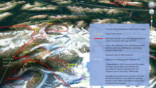
- Treaty Creek is located immediately adjacent to Seabridge Gold’s KSM and just north of Pretivm’s now producing Brucejack/Valley of the Kings high grade gold mine in northwestern British Columbia.
Cardston, Alberta–(Newsfile Corp. – April 17, 2019) – American Creek Resources Ltd. (TSXV: AMK) (“American Creek”) is pleased to announce that JV partner Tudor Gold has retained P&E Mining Consultants Inc. (“P&E”) of Brampton, Ontario for assistance in planning the upcoming 2019 drilling season, with a view to eventually compiling an initial Mineral Resource Estimate pursuant to National Instrument 43-101 for the Treaty Creek Property located immediately adjacent to Seabridge Gold’s KSM and just north of Pretivm’s now producing Brucejack/Valley of the Kings high grade gold mine in northwestern British Columbia.
P&E Mining Consultants Inc., established in 2004, provides geological and mine engineering consulting reports, Mineral Resource Estimate technical reports, Preliminary Economic Assessments and Pre-Feasibility Studies. P&E undertook the initial Mineral Resource Estimate for Pretium Resources Inc.’s Brucejack Property and the resulting Technical Report that supported the $100M IPO.
Ken Konkin, Tudor Gold’s Exploration Manager stated, “I have had the pleasure of working with Mr. Eugene Puritch, P. Eng, FEC and President of P&E Mining Consultants Inc. and his team of professional geologists and professional engineers on several projects in North and South America. P&E Mining Consultants specialize in geological modeling and mine design and their work is of the highest standards. I look forward to working again with Eugene and his geo-scientists and engineers in order to determine the optimum drill hole spacing required for the drill program. Our goal is to fast-track the exploration program at Treaty Creek during this summer adding value to Tudor’s Goldstorm target in the most efficient and economic methods possible. Once drilling begins, P&E Mining Consultants will conduct a site visit and complete a project review.”
Darren Blaney, CEO of American Creek stated: “We very much look forward to having Tudor and Mr. Konkin commence the much anticipated 2019 Treaty Creek drill program building on the last hole from 2018 that ran 563 meters of 0.98 g/t gold. Securing a top tier firm to oversee the drilling and maiden resource calculation is a very positive step in the advancement of the Treaty JV. The Golden Triangle region is heating up and attracting attention and this upcoming season is shaping up to be very significant.”
About American Creek
American Creek is a Canadian junior mineral exploration company with a strong portfolio of gold and silver properties in British Columbia. Three of those properties are located in the prolific “Golden Triangle”; the Treaty Creek and Electrum joint venture projects with Tudor Gold/Walter Storm as well as the 100% owned past producing Dunwell Mine.
The Corporation also holds the Gold Hill, Austruck-Bonanza, Ample Goldmax, Silver Side, and Glitter King properties located in other prospective areas of the province.
For further information please contact Kelvin Burton at: Phone: 403 752-4040 or Email: [email protected]. Information relating to the Corporation is available on its website at www.americancreek.com