Posted by AGORACOM
at 8:38 AM on Wednesday, March 20th, 2019
VANCOUVER, BC / ACCESSWIRE / March 20, 2019 / GGX Gold Corp. (TSX-V: GGX), (OTCQB: GGXXF), (FRA: 3SR2) (the “Company” or “GGX“)
is pleased to announce it has begun preparing for the spring 2019
diamond drilling program on the Gold Drop Property, located in Southern
British Columbia. The program is scheduled to begin in early April. The
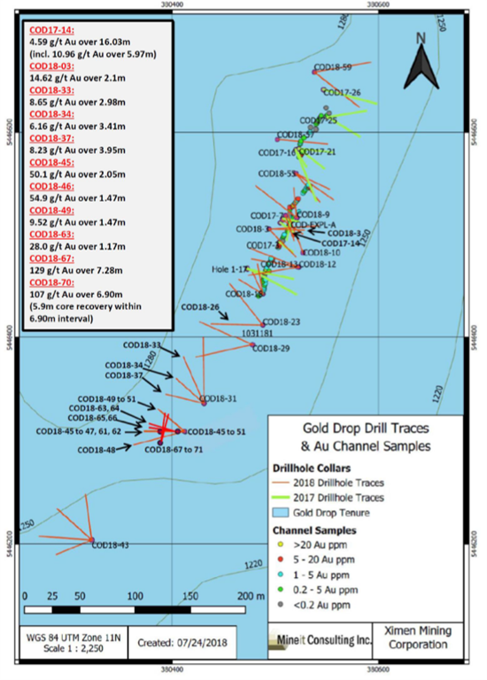
spring drilling program will focus on the COD vein located in the Gold
Drop Southwest Zone. The program will further test the southern
extension of the COD vein. The Company intersected near-surface, high-
grade gold, silver and tellurium in this part of the vein during 2018
diamond drilling.
The
highlights of the 2018 diamond drilling program are drill holes
COD18-67 and COD18-70 that intersected near-surface, high-grade gold,
silver and tellurium in the southern extension of the COD vein. COD18-67
intersected 129 grams per tonne (g/t) gold, 1154 g/t silver & 823
g/t tellurium over 7.28-meter core length while COD18-70 intersected 107
g/t gold, 880 g/t silver & 640 g/t tellurium over 6.90-meter core
length (News Releases of January 11, January 18 and March 18, 2019). The
COD vein system has been traced by trenching and diamond drilling for
close to 400 meters along strike. The vein system is open along strike
and at depth.
Intersections
for 2017 and 2018 diamond drill holes at the C.O.D. vein include the
following (please refer to the Company’s website for News Releases
announcing these results):
Other
targets in the Gold Drop Southwest Zone include the COD north region.
No previous diamond drilling has been completed in this region. The 2018
trenching program exposed numerous vein showings with grab samples up
to 15.45 g/t gold, 159 g/t silver Ag and 114.5 g/t tellurium. A chip
sample (0.4 meters long) returned 21.7 g/t gold, 216 g/t silver and 149
g/t tellurium (News Release of February 27, 2019).
Data from the previous exploration programs is currently under review to identify other specific exploration targets.
The
Company is also pleased to announce that it has arranged a non-brokered
private placement of 4.2 million flow through units at a price of
Cdn$0.12 per unit for gross proceeds of $504,000. Each Flow-Through Unit
consists of one common share that qualifies as a “flow-through share”
as defined in subsection 66(15) of the Income Tax Act and one
transferable common share purchase warrant. Each whole warrant
will entitle the holder to purchase, for a period of 18 months from the
date of issue, one additional non-flow-through common share of the
Issuer at an exercise price of Cdn$0.15 per share. The proceeds of the
private placement will be used for continued exploration work including
diamond drilling and trenching at the Company’s Gold Drop property near
Greenwood in Southern British Columbia.
A finder’s fee may be paid
to eligible finders in accordance to the TSX-V policies. All securities
issued pursuant to the offering will be subject to a hold period of
four months and one day from the date of closing. The offerings and
payment of finders’ fees are both subject to approval by the TSX-V.
David
Martin, P.Geo., a Qualified Person as defined by NI 43-101 and
consultant for GGX Gold Corp., is responsible for the technical
information contained in this News Release.
To view the Original News release with pictures please go to the website or contact the company.
On Behalf of the Board of Directors, Barry Brown, Director 604-488-3900 [email protected]
Tags: #BC, #Drilling, #Tellerium #GoldDrop, gold Posted in GGX Gold Corp. | Comments Off on GGX Gold $GGX.ca Announces Diamond Drilling Program & Financing on the Gold Drop Property $APH.ca $TUE.ca $GOM.ca $TYE.ca $NNZ.ca $GTT.ca $AOT.ca $MTB.ca
Posted by AGORACOM-JC
at 8:11 AM on Wednesday, March 20th, 2019
2018 drilling program a total success, expanding the size of the McKenzie Break deposit and confirming its high-grade potential.
Visible gold found in 17 of the 61 holes, including hole MK-18-196,
which intersected 265.00 g/t Au over 0.6 metres, and hole MK-18-216 with
93.80 g/t Au over 0.5 metres
Highlights of the third and last set of results for the 13,945-metre 2018 diamond drilling program:
Hole MK-18-236: 12.60 g/t Au over 1.35 metres, incl. 55.90 g/t Au
over 0.3 metres, and 13.40 g/t Au over 2.0 metres, incl. 26.40 g/t Au
over 1.0 metre
Hole MK-18-231: 15.74 g/t Au over 1.5 metres
Hole MK-18-222: 13.95 g/t Au over 1.0 metre
Hole MK-18-232: 6.84 g/t Au over 2.0 metres, incl. 13.65 g/t Au over 1.0 metre
MONTREAL, March 20, 2019 – MONARCH GOLD CORPORATION (“Monarch” or the “Corporation”) (TSX: MQR) (OTCMKTS: MRQRF) (FRANKFURT: MR7) is pleased to report the third and last set of assay results from the 2018 diamond drilling program at its wholly owned McKenzie Break gold project 25 kilometres north of Val-d’Or, near its Camflo and Beacon mills. The program started in September 2018 and ended in December 2018, with a total of 13,945 metres drilled in 61 holes. The purpose of the program was to explore below the known lenses and on the periphery of the multi-vein Green and Orange zones. Assays have been received for the last 20 holes totalling 5,052 metres of core (see table below and press releases dated February 28, 2019  and March 13, 2019 for a compilation of the 2018 assay results).
“With the solid high-grade results obtained from our 2018 drilling
program, we have upgraded the status of McKenzie Break as one of our
prime advanced exploration projects,” said Jean-Marc Lacoste,
President and Chief Executive Officer of Monarch. “The program
delivered beyond our expectations, enabling us to establish that the
deposit remains open to the west, east, north and at depth and continues
to hold excellent high-grade gold potential (see plan view and longitudinal).
In fact, the next resource estimate has the potential to expand the
underground deposit by 250 metres to the east, 100 metres to the north
and 50 metres to the west. There is still a lot of exploration work to
be done to fully assess the size and magnitude of this deposit, which
remains largely underexplored. We are presently analyzing the results of
the 2018 drilling and planning the follow-up program for 2019.”
Hole MK-18-236 returned 12.60 g/t Au over 1.35 metres, including
55.90 g/t Au over 0.3 metre at 80 metres below surface. This interval is
65 metres southeast of hole MK-18-210, which returned a grade of 12.50
g/t Au over half a metre from the same horizon as hole MK-18-236,
thereby extending the lens to the east and showing that it is still
open. Hole MK-18-236 also intersected another lens, at a depth of 145
metres from surface, with values of 13.40 g/t Au over 2.0 metres,
including 26.40 g/t Au over 1.0 metre, and 75 metres north, on the same
horizon, hole MK-18-232 returned values of 6.84 g/t Au over 2.0 metres,
including 13.65 g/t Au over 1.0 metre. These two intersections are
connected by hole MK-18-211, 100 metres northwest of hole MK-18-236. The
combination of these three holes on the same horizon will increase the
underground resource in this sector.
Hole MK-18-231, which returned a grade of 15.74 g/t Au over 1.5
metres, is to the north of the planned Green Zone open pit, in the
middle of a triangle of three holes drilled by Monarch in 2018. These
four holes are interpreted as being connected and are on the same
horizon, creating a new lens. The three other holes are an average of 65
metres from hole MK-18-231 and grade an average of 5.42 g/t Au. The
lens lies 200 metres below surface.
Hole MK-18-222 returned a grade of 13.95 g/t Au over 1.0 metre from
68 metres below surface. This intersection is 70 metres northwest of the
Green Zone open pit and will help to increase the underground resource.
Third set of drill results for the McKenzie Break property:
Hole
Length
From
To
Width*
Grade Au
number
(m)
(m)
(m)
(m)
(g/t)
MK-18-222
177
64.1
65.0
0.9
5.14
68.0
69.0
1.0
13.95
102.0
103.0
1.0
4.68
141.0
142.5
1.5
5.40
Including
141.0
141.5
0.5
14.00
MK-18-223
150
20.7
22.6
1.9
6.18
Including
21.6
22.1
0.5
8.99
65.4
66.3
0.9
2.03
69.6
70.6
1.0
3.69
100.5
105.1
4.6
2.18
Including
102.8
103.9
1.1
3.95
122.8
125.3
2.5
2.19
Including
124.0
125.3
1.3
3.17
MK-18-224
210
174.0
178.0
4.0
2.75
Including
177.0
178.0
1.0
6.11
MK-18-225
210
68.0
68.5
0.5
8.11
175.0
176.3
1.3
2.42
MK-18-226
276
244.55
246.5
1.95
3.09
Including
246.0
246.5
0.5
9.58
274.1
275.0
0.9
2.70
MK-18-227
228
101.0
101.5
0.5
3.86
168.7
171.8
3.1
0.89
Including
170.5
171.1
0.6
2.74
MK-18-228
216
34.0
37.0
3.0
2.42
88.0
89.0
1.0
9.37
MK-18-229
243
103.0
104.0
1.0
2.79
196.0
198.0
2.0
1.61
Including
197.0
198.0
1.0
2.39
MK-18-230
270
152.0
153.0
1.0
3.54
175.5
176.2
0.7
2.59
198.0
200.0
2.0
3.84
Including
199.0
200.0
1.0
6.20
MK-18-231
258
197.0
198.5
1.5
17.45
197.0
211.0
14.0
2.38
MK-18-232
252
158.0
160.0
2.0
6.84
Including
159.0
160.0
1.0
13.65
188.0
189.0
1.0
3.25
MK-18-233
247
137.75
138.5
0.75
1.36
MK-18-234
276
234.0
235.8
1.8
7.80
Including
235.0
235.8
0.8
17.30
MK-18-235
269
138.0
139.0
1.0
2.19
244.65
248.0
3.35
3.83
Including
244.65
245.4
0.75
10.60
MK-18-236
288
77.65
79.0
1.35
12.6
Including
77.65
77.95
0.3
55.9
143.0
145.0
2.0
13.40
Including
143.0
144.0
1.0
26.40
236.0
236.55
0.55
3.10
277.0
279.0
2.0
2.36
281.0
282.0
1.0
2.05
MK-18-237
300
249.7
250.7
1.0
2.42
261.7
262.25
0.55
2.67
MK-18-238
300
172.6
173.3
0.7
2.26
228.0
228.5
0.5
2.19
259.8
261.0
1.2
2.72
MK-18-239
306
199.0
200.0
1.0
3.57
204.4
205.5
1.1
2.10
MK-18-240
324
176.8
178.3
1.5
5.90
Including
176.8
177.3
0.5
17.5
182.8
183.7
0.9
4.09
MK-18-245
252
123.4
125.3
1.9
1.07
*The width shown is the core length. True width is estimated to be 90-100% of the core length.
McKenzie Break is a high-grade, multiple-narrow-vein gold deposit
hosted in the dioritic Pascalis batholith and underlain by porphyritic
diorite and mafic and felsic volcanic rocks. On June 14, 2018,
the Corporation reported an NI 43-101 pit-constrained resource of
48,133 ounces in the Indicated category and 14,897 ounces in the
Inferred category on the property, as well as an underground resource of
53,448 ounces in the Indicated category and 49,130 ounces in the
Inferred category, for a total of 165,608 ounces of gold (Source: NI
43-101 Technical Report on the McKenzie Break Project, April 17, 2018, Alain-Jean Beauregard, P.Geo., and Daniel Gaudreault, Eng., of Geologica Groupe-Conseil Inc., and Christian D’Amours, P.Geo., of GeoPointCom Inc.).
Sampling normally consists of sawing the core into equal halves along
its main axis and shipping one of the halves to the ALS Minerals
laboratory in Val-d’Or, Quebec for assaying. The samples
are crushed, pulverized and assayed by fire assay, with atomic
absorption finish. Results exceeding 3.0 g/t Au are re-assayed using the
gravity method, and samples containing visible gold grains are assayed
using the metallic sieve method. Monarch uses a comprehensive QA/QC
protocol, including the insertion of standards, blanks and duplicates.
The technical and scientific content of this press release has been reviewed and approved by Ronald G. Leber, P.Geo., the Corporation’s qualified person under National Instrument 43-101.
ABOUT MONARCH GOLD CORPORATION
Monarch Gold Corporation (TSX: MQR) is an emerging gold mining
company focused on pursuing growth through its large portfolio of
high-quality projects in the Abitibi mining camp in Quebec, Canada. The Corporation currently owns close to 300 km² of gold properties (see map),
including the Wasamac deposit (measured and indicated resource of 2.6
million ounces of gold), the Beaufor Mine, the Croinor Gold (see video), McKenzie Break and Swanson
advanced projects and the Camflo and Beacon mills, as well as other
promising exploration projects. It also offers custom milling services
out of its 1,600 tonne-per-day Camflo mill.
Forward-Looking Statements The forward-looking
statements in this press release involve known and unknown risks,
uncertainties and other factors that may cause Monarch’s actual results,
performance and achievements to be materially different from the
results, performance or achievements expressed or implied therein.
Neither TSX nor its Regulation Services Provider (as that term is
defined in the policies of the TSX accepts responsibility for the
adequacy or accuracy of this press release.
Tags: #mining, gold, monarch, monarques, tsx, tsx-v Posted in All Recent Posts, Monarques Gold | Comments Off on Monarch Gold $MQR.ca Intersects 12.60 g/t Au over 1.35 metres, including 55.90 g/t Au over 0.3 metres, at its Mckenzie Break Gold Project $GDX.ca $ECR.ca $MZZ.ca $QMX.ca $IMG.ca $IAG $MUX
VANCOUVER, BC / ACCESSWIRE / March 18, 2019 / GGX Gold Corp. (TSX-V: GGX), (OTCQB: GGXXF), (FRA: 3SR2) (the “Company” or “GGX“)
is pleased to announce it has received tellurium analytical results for
select drill core samples from the Fall 2018 diamond drill program at
the Gold Drop Property, located in southern British Columbia. The Fall
2018 drill program was conducted at the C.O.D. Vein, located in the Gold
Drop Southwest Zone. The tellurium results are re-analyses of drill
core samples from drill holes COD18-67 and COD18-70 which initially
exceeded the upper 500 grams per tonne (g/t) analytical limit for
tellurium. The re-analyses confirm high-grade tellurium for these drill
holes, being associated with high-grade gold and silver (gold and silver
results reported in News Releases of January 11 and 18, 2019):
The
2018 Fall diamond drill program tested the COD vein. The program
followed up on results from previous 2018 diamond drilling at the
southern extension of the COD vein. The highlights of the 2018 Fall
drill program are drill hole COD18-67 which intersected 129.1 g/t gold
and 1,154 g/t silver over 7.28 meters core length and drill hole
COD18-70 which intersected 107.5 g/t gold and 880 g/t silver over 6.90
meters core length (News Releases of January 11and 18, 2019). Both holes
were drilled slightly northeast from the same site (COD18-67 at a
50-degree dip and COD-18-70 at a 54-degree dip) to intersect the
northwest trending COD Vein at a shallower angle, the objective to test
the continuity of the quartz veining and mineralization.
Fourteen
drill core samples from the high-grade gold and silver intersections of
drill holes COD18-67 and COD18-70 returned greater than the upper
analytical limit of 500 g/t for tellurium during initial analysis (four
acid ICP-MS analysis by ALS Canada Ltd. in North Vancouver). As a
result, the tellurium weighted average grades for these intersections
could not be determined from initial analyses. ALS Canada Ltd. recently
re-analyzed these 14 samples for tellurium by four acid ICP-AES. These
new analytical results confirm high grade tellurium within the
high-grade gold and silver intersections. For drill hole COD18-67, the
near-surface interval of 23.19-30.47m (7.28 meters core length) graded
823.4 g/t tellurium. For drill hole COD18-70, the near-surface interval
of 22.57-29.47m (6.90 meters core length) graded 640.5 g/t Tellurium.
The 14 drill samples are listed as follows (core length):
Hole No.
From (m)
To (m)
Length (m)
Te (G/T)
Sample No.
COD18-67
23.58
23.95
0.37
880
V108489
COD18-67
24.50
25.10
0.60
560
V108491
COD18-67
25.10
25.50
0.40
770
V108492
COD18-67
25.50
26.06
0.56
900
V108493
COD18-67
26.06
26.34
0.28
930
V108494
COD18-67
26.34
26.72
0.38
2,250
V108495
COD18-67
26.72
27.10
0.38
3,860
V108496
COD18-67
27.10
27.63
0.53
1,550
V108497
COD18-67
29.70
30.04
0.34
1,090
V108503
COD18-67
30.04
30.47
0.43
710
V108504
COD18-70
22.57
22.95
0.38
690
V108537
COD18-70
23.30
23.75
0.45
3,340
V108539
COD18-70
23.75
24.15
0.40
2,960
V108541
COD18-70
26.19
26.98
0.79
830
V108544
Intersections
for 2017 and 2018 diamond drill holes at the C.O.D. vein include the
following (please refer to the Company’s website for News Releases
announcing these results):
Hole ID
Interval Length (m)
Gold (gpt)
Silver (gpt)
Te (gpt)
COD17-14
16.03
4.59
38.64
COD18-3
2.1
14.62
150.2
102
COD18-26
1.4
10.3
1.09
0.24
COD18-32
1.51
3.67
67.2
30.4
COD18-33
2.98
8.65
47.6
37.3
COD18-34
3.41
6.16
72.4
31
COD18-37
3.95
8.23
67.36
38.53
COD18-45
2.05
50.15
375
COD18-46
1.47
54.9
379
COD18-49
1.47
9.52
118
72.2
COD18-54
1.66
7.6
60.2
34.1
COD18-61
1.38
5.29
32.4
31.4
COD18-63
1.17
28
424.7
150.4
COD18-67
7.28
129.1
1,154.90
823
COD18-68
2.76
8.77
85.4
56.3
COD18-69
7.46
5.76
67.9
61.2
COD18-70
6.9
107.5
880
640
Tellurium
remains as one of the rarest elements on earth. Tellurium production
has been a by-product of copper and gold mining. The production is
limited, estimated to being on the order of 800 metric tonnes per year.
According to the USGS total production for 2007 was 107 Mtonnes.
Up
to recently, the sole use of tellurium has been alloying of other
metals to increase the machinability of copper or to decrease the
corrosive action of sulfuric acid on lead.
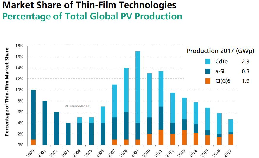
The most significant
modern use of tellurium is the Cadmium-telluride (Cd-Te) photovoltaic
solar cells. These solar cells are the forefront of solar power. One
gigawatt (GW) of Cd-Te, at current efficiencies, would require
approximately 93 metric tons of tellurium. These cells have the smallest
carbon footprint and the shortest energy payback time of all solar
cells. The efficiency of technology is constantly improving and the
Cd-Te now takes up 5.1% of worldwide PV production.
PHOTOVOLTAICS REPORT, Freiburg, 27 August 2018
In
the C.O.D vein system the tellurium occurs as a soft silver-grey
telluride mineral. The telluride mineral is a Silver-Tellurium-Gold
alloy speculated to be sylvanite. Whenever this mineral is observed in
the drill core the interval has elevated silver, gold and tellurium
values.
David Martin, P.Geo., a Qualified Person as defined by NI
43-101 and consultant for GGX Gold Corp., is responsible for the
technical information contained in this News Release.
To view the Original News release with pictures please go to the website or contact the Company.
On Behalf of the Board of Directors, Barry Brown, Director 604-488-3900
Tags: #Assay, #BC, #Discovery, #GoldDrop, #silver, $GGX, gold Posted in GGX Gold Corp. | Comments Off on $GGX.ca GGX Gold Drill Core Samples Return up to 3,860 G/T Tellurium at the C.O.D. Vein Southern British Columbia $APH.ca $TUE.ca $GOM.ca $TYE.ca $NNZ.ca $GTT.ca $AOT.ca $MTB.ca
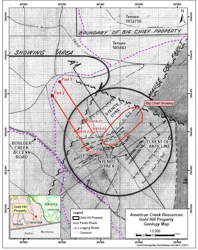
Posted by AGORACOM
at 9:02 AM on Friday, March 15th, 2019
100% owned Gold Hill property located in the Boulder Creek drainage, a tributary of the Wildhorse River
4 diamond drill holes on two sections totaling 2,087 meters of drilling. Nine hundred and twenty nine (929) drill core samples
This is the first time area has been drilled. The program successfully intersected multiple zones of gold.
A high grade intersection in hole NS18-01 contained 66.4 g/t gold over 0.2 meters (true width unknown)
Cardston, Alberta–(Newsfile Corp. – March 15, 2019) – American Creek Resources Ltd.
(TSXV: AMK) (“American Creek”) is pleased to report on drilling results
from the late fall exploration program conducted on its 100% owned Gold
Hill property located in the Boulder Creek drainage, a tributary of the
Wildhorse River east of Fort Steele, British Columbia. The preliminary
program included four diamond drill holes on two sections totaling 2,087
meters of drilling. Nine hundred and twenty nine (929) drill core
samples were analyzed.
The management and professionals that
guided the exploration program are pleased and very encouraged by the
results. There were multiple gold intersections in all 4 preliminary
drill holes. A summary of the significant intersections and gold values
is contained herein.
The 2018 drill program was conducted to test
a Cretaceous age swarm of syenite porphyry dykes intruded into lower
and middle Cambrian sediments. This is the first time that this package
of rocks has ever been drilled. The drill program successfully
intersected multiple zones of gold associated with several syenite dike
targets as well as significant intervals of highly altered, silicified
rock. In addition, there were several intersections of highly altered
and, in some cases, calcareous sediments, some of which contained
elevated gold values. These altered sediments will be further explored
for gold content. They will also be useful as marker horizons guiding
future drilling.
A high grade intersection in hole NS18-01
contained 66.4 g/t gold over 0.2 meters (true width unknown). This
intersection correlates with prior historic gold values obtained in the
area. Car samples and face samples from a drift (small tunnel) driven
partially along the hanging wall of a syenite porphyry dyke in 1937 were
assayed over a width of 1.5 feet (~0.5m). The car samples averaged
0.43 oz. Au per ton (13.4 g/t), 0.48 oz. (14.9g/t) Ag per ton and 2.3%
Pb per ton over 40 feet (12.2m). The face samples along 22 feet (6.7m)
averaged at 2.4 oz. Au per ton (74.6 g/t) 2.17 oz. (67.5 g/t) Ag per
ton and 5.51% Pb.
The Gold Hill property covers approximately 836
hectares and is located along the eastern edge of the Kimberly Gold
Trend. The property is road accessible by paved highway to Fort Steele
and then by main logging roads to (and through) the property. Driving
time from Cranbrook to the center of the property is less than one hour.
The
property contains a significant portion of the Boulder Creek drainage, a
tributary of the Wild Horse River which is considered to be one of the
greatest placer gold rivers in the entire province. Gold rushes have
taken place there since the 1860’s that have yielded over 48 tonnes of
reported gold, making it Canada’s 4th largest placer producer. The
majority of the gold recovered from the Wild Horse was located along a 6
km stretch between Boulder Creek (upstream) and Brewery Creek
(downstream). From the point where Boulder Creek enters the Wild Horse
River for a distance of 6 kilometers downstream, a minimum of 1.5
million ounces (45,655,215 grams) of placer gold was recovered between
1864 and the 1930’s. In addition, an undetermined amount of placer gold
was sold in the United States during this period but no records of the
amount are available. The Boulder Creek drainage is the logical source
of the placer gold recovered from the Wildhorse River below.
Early
efforts by prospectors to locate the source of the Wild Horse placer
gold led explorers up Boulder Creek to what is now called the Gold Hill
property. Although lode gold was first found in the area by prospectors
in the late 1800’s, the Gold Hill property has not been the subject of
any systematic modern exploration and prior to this program, the
property has never been drill tested.
Significant Intercepts from Preliminary 2018 Drill Program
Gold
values, as tested by initial ICP analysis, range from slightly less
than 0.5 g/t to 5.68 g/t. With reference to sample 043174 in hole
NS18-01, where the initial analysis placed gold at >30,000 ppb (30.0
g/t), total metal analysis of the same sample returned a value of 66.4
g/t. To date, this is the only sample that has been analyzed for total
metal. It was originally selected because of the proximal galena and
visible gold.
Historical work on the property has noted the
presence of metallic gold in samples that is not detected by
conventional ICP analysis. A skilled, well trained and experienced
Prospector discusses this phenom in Assessment Report 27,173 (Dec. 29,
2004). Again, in AR 34,920, (July 2015) a P. Geo. explained the presence
of metallic gold. The following is a direct quote from AR 34,920 by the
highly experienced P. Geo. who mapped the property: “work by the
original prospectors and miners on the property from 1898 to 1957 did a
good job of exposing gold-bearing structures and the related sulphides
and gangue minerals. This work demonstrated the course nature of the gold which is commonly visible to the naked eye.”
In
light of the strong possibility that metallic gold was missed by the
initial assaying, further assay work including advanced testing for
metallics will be conducted. As a first step, 12 samples, all of which
indicate significant gold values, have been selected for total metal
analysis. The company is looking forward to receiving the total metal
gold value for the 12 samples selected for this purpose. The results
will be available when the additional assay analysis is completed.
There is some correlation between anomalous Pb in the samples with higher gold values however, they do not always correlate.
Frank
O’Grady, P. Eng. and QP for the project stated: “This first look at the
underground geological structure in the Big Chief area of the property
is very encouraging. Not only are we seeing gold associated with
multiple syenite dyke contacts, but we are also seeing gold showing up
in the highly altered sediments. To have intersected gold in every hole,
especially since we had no prior drill holes on the property to guide
us, indicates the potential scope and scale of the property’s potential
going forward. We clearly have a large gold system we are dealing with
here.”
Darren Blaney, CEO of American Creek stated: “This is a
significant first step in unravelling the mystery of the potential
source of the large quantity of Wild Horse river placer gold collected
downstream. Not only are we seeing widespread gold mineralization on
surface, but we now also have our first glimpse at what is going on
underneath a portion of the property. This preliminary program will be a
tremendous aid in guiding future work on the project.”
There are two main highly prospective targets on the property:
1.
The Midas / Gold Hill prospect which is situated on the southern part
of the property. The Midas is in an area of steep topography and is
structurally controlled.
2. The Big Chief prospect which is
situated on the northern portion of the property. The Big Chief is
located on an area of moderate relief and is formed by hydrothermal
activity from intruded syenite dikes of Cretaceous age.
The
property is nominally divided into north and south portions by Boulder
Creek which flows westerly through the property. This phase of the
exploration program focused solely on a portion of the Big Chief
prospect. The highly prospective area of the property situated south of
Boulder Creek was not explored during 2018. This southern area, which
includes high grade gold values in grab samples including 25.14 g/t from
the Guggenheim showing, will be included in 2019 exploration.
Initial
logging of the core combined with sample results has provided a basic
understanding of the underground geological structure as well as the
gold and accompanying metals present in the previously undrilled package
or rocks underlying the Big Chief showings.
Sections containing
increased Au, sometimes Ag and in several cases increased base metals
which include Pb, Cu and Zn are contained in sections of intense
alteration. This alteration includes, but may not be limited to,
silicification, sericitization, carbonatization (in some places) and
increased epidote.
The core will be carefully re-examined during
2019 with key sections being relogged. The initial logging was done
under inclement conditions including low temperatures and poor light and
without the benefit of any prior drill core assays for reference.
Qualified Person
Frank
O’Grady, P.Eng., is the Qualified Person as defined by National
Instrument 43-101 for the Gold Hill Project and for this news release.
American Creek holds a strong portfolio of gold and silver properties in British Columbia.
Three
of those properties are located in the prolific “Golden Triangle”; the
Treaty Creek and Electrum joint venture projects with Tudor Gold (Walter
Storm) as well as the 100% owned past producing Dunwell Mine.
The
Corporation also holds the Austruck-Bonanza, Ample Goldmax, Silver
Side, and Glitter King properties located in other prospective areas of
the province.
For further information please contact Kelvin Burton at: Phone: 403 752-4040 or Email: [email protected]. Information relating to the Corporation is available on its website at www.americancreek.com
Tags: #Drilling, #GoldHill, #SteeleBC, $AMK, gold Posted in American Creek Resources Ltd. | Comments Off on $AMK.ca American Creek Intersects Gold in All Four Preliminary Holes at Gold Hill Project – up to 66.4 G/T Gold over 0.2 Meters $SEA $SA $SKE.ca $TUD.ca $PVG $MRO.ca
Posted by AGORACOM
at 10:21 AM on Wednesday, March 13th, 2019
American Creek has operated in the Golden Triangle region for 15 years and has three noteworthy projects.
Ken Konkin (former head geologist for Pretivm and instrumental in the discovery and development of the Brucejack / VOK mine) now heading our JV partner Tudor Gold’s geological team to develop Treaty Creek.
The geology, geophysics and structure are showing potential for similar scale to the rest of the Sulphurets Hydrothermal System, and the drilling to date is confirming
The string of porphyry related deposits running through the Sulphurets Hydrothermal system have stronger gold equivalent grades the further north you go. The Goldstorm deposit on Treaty Creek property is richer in gold and total gold equivalent than the KSM deposits further to the south
Treaty Creek is “on the right side of the hill” where there is direct access to highway 37 and the high-power transmission line making logistics markedly better than for deposits further south.
The Treaty Creek JV property has a fully carried interest to production
Posted by AGORACOM
at 8:34 AM on Wednesday, March 13th, 2019
Labrador Gold controls 57 kilometre a strike length of stratigraphy prospective for gold in the Florence Lake Greenstone Belt. Hopedale Project
Exploration program at Hopedale followed up on successful results of 2017 work that outlined regional scale gold in soil and lake sediment anomalies
Of these samples, 80 assayed greater than 0.1 g/t gold including 17 samples that assayed greater than 1 g/t gold.
VANCOUVER,
British Columbia, March 13, 2019 (GLOBE NEWSWIRE) — Labrador Gold
Corp. (TSX-V: LAB) (“Labrador Gold†or the “Companyâ€) is pleased to
announce assay results for rock samples from its Hopedale project in
Labrador. The company controls a 57 kilometre strike length of
stratigraphy prospective for gold in the Florence Lake Greenstone Belt.
The exploration program at Hopedale followed up on successful results of
2017 work that outlined regional scale gold in soil and lake sediment
anomalies along the length of the belt and included detailed soil
sampling, geological mapping, rock sampling and prospecting.
A
total of 588 rock samples were taken along the length of the Florence
Lake Greenstone Belt during the regional prospecting and mapping
program. Of these samples, 80 assayed greater than 0.1 g/t gold
including 17 samples that assayed greater than 1 g/t gold. Results of
the assays ranged from below the detection limit of 0.05 g/t to 11.4 g/t
gold in a grab sample from a quartz vein with pyrite and arsenopyrite.
Additional highlights include channel samples of 2.77 g/t gold over 2.1
metres and 2.37 g/t gold over 2 metres. Highlights of gold assays of
grab samples include 4.55g/t gold from quartz porphyry and 2.52g/t and
2.46g/t gold from quartz veins that were altered or contained sulphide.
Complete highlights of the program are shown in the table below.
Sample ID
Area
Sample Type*
Length
Au g/t
Description
1685504 to 506
Thurber Dog
Channel
3.5
0.47
Quartz veins in Quartz porphyry
1685506
Thurber Dog
including
1
0.86
Quartz Porphyry
1685509 to 510
Thurber Dog
Channel
2
0.91
Felsic volcanic
1685509
Thurber Dog
including
1
1.27
Quartz vein
1685555 to 556
Thurber North
Channel
2
2.36
Quartz Porphyry
1685556
Thurber North
Including
1
2.73
Quartz Porphyry
1685566
Thurber North
Channel
0.5
0.92
Ferruginous quartz vein
1685589
Thurber North
Channel
0.56
0.48
Quartz vein with iron Carbonate
1685613
Thurber South
Channel
1.2
0.65
Carbonate altered mafic volcanic
1685632 to 633
Thurber South
Channel
2.1
2.77
Chlorite altered Mafic volcanic with quartz veins
1685632
Thurber South
including
1.2
3.99
Quartz vein with Fe oxide
1693835
Thurber Dog
Grab
n/a
1.01
Quartz vein with Arsenopyrite
1685854
Shirley
Grab
n/a
1.09
Phyllite with arsenopyrite
1690808
Thurber Dog
Grab
n/a
1.45
Felsic volcanic/Quartz Porphyry
1692276
Thurber South
Grab
n/a
1.64
Quartz Vein
1692279
Thurber South
Grab
n/a
1.74
Quartz Vein
1693836
Thurber North
Grab
n/a
1.84
Silicified ultramafic with quartz veining and arsenopyrite
1685851
Shirley
Grab
n/a
2.46
Quartz-carbonate vein with pyrite
1692283
Thurber South
Grab
n/a
2.52
Quartz vein with iron carbonate
1656525
Thurber North
Grab
n/a
4.55
Quartz porphyry
1693833
Thurber Dog
Grab
n/a
11.40
Quartz vein with pyrite and arsenopyrite
*Note that grab samples are select samples and are not necessarily representative of gold mineralization found on the property.
While
rock samples containing anomalous gold are found in many parts of the
greenstone belt, most of the samples above 0.1g/t gold occur in the
Jasmine/Shirley and Thurber Dog areas of the belt. At Jasmine/Shirley,
the gold mineralization is associated with altered mafic volcanic rocks
and phyllite that contain varying amounts of arsenopyrite from
disseminated grains to veins of massive arsenopyrite. The highest-grade
rocks in the area are from quartz veins with iron carbonate alteration.
At
Thurber Dog, gold mineralization is associated primarily with altered
porphyritic felsic volcanic rocks and quartz veins around the Thurber
Dog occurrence and in the Thurber North area. At Thurber South the
mineralization is associated with intensely carbonate altered ultramafic
and mafic volcanic rocks and associated quartz veins. The mineralized
rocks typically contain disseminated pyrite and, more rarely
arsenopyrite.
“The results of our prospecting
at Hopedale are very encouraging, especially since this was our first
systematic rock sampling of the greenstone belt.†said Roger Moss,
President and Chief Executive Officer of Labrador Gold. “Over 13% of the
samples taken along the length of the belt returned results of more
than 0.1 g/t gold and will be followed up in detail. In addition,
significantly anomalous gold mineralization previously identified over a
three kilometre strike length in the Thurber Dog portion of the belt
continues to show excellent potential.â€
All
samples were shipped to the Bureau Veritas preparation laboratory in
Timmins, Ontario, where they were crushed and split and a 500g sub
sample pulverized to 200 mesh. Pulps were sent to the Vancouver
laboratory for assay. Samples of 30g were analyzed for gold by fire
assay with an atomic absorption finish and another 15g sample for 36
elements by ultratrace ICP-MS (inductively coupled plasma-mass
spectrometry) following an aqua regia digestion. Overlimit samples
(greater than 10g/t Au) are re-assayed using fire assay with a
gravimetric finish. In addition to the QA-QC conducted by the
laboratory, the Company routinely submits blanks, field duplicates and
certified reference standards with batches of samples to monitor the
quality of the analyses.
Roger Moss, PhD., P.Geo., is the qualified person responsible for all technical information in this release.
The
company gratefully acknowledges the Newfoundland and Labrador Ministry
of Natural Resources’ Junior Exploration Assistance (JEA) Program for
its financial support for exploration of the Hopedale property.
About Labrador Gold:
Labrador
Gold is a Canadian based mineral exploration company focused on the
acquisition and exploration of prospective gold projects in the
Americas. In 2017 Labrador Gold signed a Letter of Intent under which
the Company has the option to acquire 100% of the 896 square kilometre
(km2) Ashuanipi property in northwest Labrador and the Hopedale (458 km2) property in eastern Labrador.
The
Hopedale property covers much of the Hunt River and Florence Lake
greenstone belts that stretch over 80 km. The belts are typical of
greenstone belts around the world but have been underexplored by
comparison. Initial work by Labrador Gold during 2017 show gold
anomalies in soils and lake sediments over a 3 kilometre section of the
northern portion of the Florence Lake greenstone belt in the vicinity of
the known Thurber Dog gold showing where grab samples assayed up to
7.8g/t gold. In addition, anomalous gold in soil and lake sediment
samples occur over approximately 40 kilometres along the southern
section of the greenstone belt (see news release dated January 25th 2018 for more details). Labrador Gold now controls approximately 57km strike length of the Florence Lake Greenstone Belt.
The
Ashuanipi gold project is located just 35 km from the historical iron
ore mining community of Schefferville, which is linked by rail to the
port of Sept Iles, Quebec in the south. The claim blocks cover large
lake sediment gold anomalies that, with the exception of local
prospecting, have not seen a systematic modern day exploration program.
Results of the 2017 reconnaissance exploration program following up the
lake sediment anomalies show gold anomalies in soils and lake sediments
over a 15 kilometre long by 2 to 6 kilometre wide north-south trend and
over a 14 kilometre long by 2 to 4 kilometre wide east-west trend. The
anomalies appear to be broadly associated with magnetic highs and do not
show any correlation with specific rock types on a regional scale (see
news release dated January 18th 2018). This suggests a
possible structural control on the localization of the gold anomalies.
Historical work 30 km north on the Quebec side led to gold intersections
of up to 2.23 grams per tonne (g/t) Au over 19.55 metres (not true
width) (Source: IOS Services Geoscientifiques, 2012, Exploration and
geological reconnaissance work in the Goodwood River Area, Sheffor
Project, Summer Field Season 2011). Gold in both areas appears to be
associated with similar rock types.
The Company has 56,264,022 common shares issued and outstanding and trades on the TSX Venture Exchange under the symbol LAB.
Posted by AGORACOM
at 8:18 AM on Thursday, March 7th, 2019
Requested tellurium re-analysis of select drill core samples from the Fall 2018 diamond drill program at the Gold Drop Property, located in southern British Columbia
Multiple drill core samples from drill holes COD18-67 and COD18-70 exceeded the upper 500 grams per tonne (g/t) analytical limit for tellurium.
The 2018 Fall diamond drill program tested the COD vein. The program followed up on results from previous 2018 diamond drilling at the southern extension of the COD vein. The highlights of the 2018 Fall drill program are drill hole COD18-67 which intersected 129 g/t gold and 1,154 g/t silver over 7.28 meters core length and drill hole COD18-70 which intersected 107.5 g/t gold and 880 g/t silver over 6.90 m
VANCOUVER, BC / ACCESSWIRE / March 7, 2019 / GGX Gold Corp. (TSX-v: GGX), (OTCQB: GGXXF), (FRA: 3SR2) (the “Company” or “GGX“)
is pleased to announce it has requested tellurium re-analysis of select
drill core samples from the Fall 2018 diamond drill program at the Gold
Drop Property, located in southern British Columbia. The Fall 2018
drill program was conducted at the C.O.D. Vein, located in the Gold Drop
Southwest Zone. Multiple drill core samples from drill holes COD18-67
and COD18-70 exceeded the upper 500 grams per tonne (g/t) analytical
limit for tellurium. These samples returned high grade values for gold
and silver. These samples will be re-analyzed to determine tellurium
grades. Highlights from the Fall 2018 drill program include (News
Releases of January 11 and 18, 2019):
The
2018 Fall diamond drill program tested the COD vein. The program
followed up on results from previous 2018 diamond drilling at the
southern extension of the COD vein. The highlights of the 2018 Fall
drill program are drill hole COD18-67 which intersected 129 g/t gold and
1,154 g/t silver over 7.28 meters core length and drill hole COD18-70
which intersected 107.5 g/t gold and 880 g/t silver over 6.90 meters
core length (News Releases of January 11 and 18, 2019). Intersections
for 2017 and 2018 diamond drill holes at the C.O.D. vein include the
following (please refer to the Company’s website for News Releases
announcing these results):
Hole ID
Interval Length
Gold (gpt)
Silver (gpt)
Te (gpt)
COD17-14
16.03
4.59
38.64
COD18-3
2.1
14.62
150.2
102
COD18-26
1.4
10.3
1.09
0.24
COD18-32
1.51
3.67
67.2
30.4
COD18-33
2.98
8.65
47.6
37.3
COD18-34
3.41
6.16
72.4
31
COD18-37
3.95
8.23
67.36
38.53
COD18-45
2.05
50.15
375
COD18-46
1.47
54.9
379
COD18-49
1.47
9.52
118
72.2
COD18-54
1.66
7.6
60.2
34.1
COD18-61
1.38
5.29
32.4
31.4
COD18-63
1.17
28
424.7
150.4
COD18-67
7.28
129.11
1,154.90
COD18-68
2.76
8.77
85.4
56.3
COD18-69
7.46
5.76
67.9
61.2
COD18-70
6.9
107.5
880
Fourteen
drill core samples from the high-grade gold and silver intersections of
drill holes COD-18-67 and COD-18-70 returned greater than the upper
analytical limit of 500 g/t for tellurium during initial analysis (four
acid ICP-MS analysis by ALS Canada Ltd. in North Vancouver). As a
result, the tellurium weighted average grade for these intersections
could not be determined. The Company has requested ALS Canada Ltd. to
re-analyze these samples for tellurium.
Tellurium
(Te) remains as one of the rarest elements on earth. Tellurium
production has been a by-product of copper and gold mining. The
production is limited, estimated to being on the order of 800 metric
tonnes per year. According to the USGS total production for 2007 was 107
Mtonnes.
Up to recently, the sole use of tellurium has been
alloying of other metals to increase the machinability of copper or to
decrease the corrosive action of sulfuric acid on lead.
The most
significant modern use of tellurium is the Cadmium-telluride (Cd-Te)
photovoltaic solar cells. These solar cells are the forefront of solar
power. One gigawatt (GW) of Cd-Te, at current efficiencies, would
require approximately 93 metric tons of tellurium. These cells have the
smallest carbon footprint and the shortest energy payback time of all
solar cells. The efficiency of technology is constantly improving and
the Cd-Te now takes up 5.1% of worldwide PV production.
PHOTOVOLTAICS REPORT, Freiburg, 27 August 2018 (To view the full-size image, please click here)
In
the C.O.D vein system the tellurium occurs as a soft silver-grey
telluride mineral. The telluride mineral is a Silver-Tellurium-Gold
alloy speculated to be sylvanite. Whenever this mineral is observed in
the drill core the interval has elevated silver, gold and tellurium
values.
David Martin, P.Geo., a Qualified Person as defined by NI
43-101, is responsible for the technical information contained in this
News Release.
To view the Original News release with pictures please go to the website or contact the Company.
On Behalf of the Board of Directors, Barry Brown, Director 604-488-3900 [email protected]
Tags: #BC, #CODVein, #Discovery, #HighGrade, #silver, #tellerium, gold Posted in GGX Gold Corp. | Comments Off on GGX Gold Requests Tellurium Re-Analysis of Select 2018 High Grade Drill Core Samples at the C.O.D. Vein – Southern British Columbia $APH.ca $TUE.ca $GOM.ca $TYE.ca $NNZ.ca $GTT.ca $AOT.ca $MTB.ca
Posted by AGORACOM
at 1:39 PM on Tuesday, March 5th, 2019
Advance Gold has Identified up to 30 Epithermal veins through the first 2 stages of drilling.
AGT-02 Tabasquena intersected 19m of core and is discovery hole of 1.7m of 9.64g/t gold in first 10 metres assayed.
La Chiquita – 4.70m Intersection from (109.25 to 113.95) in AGT-04
AGT-04 Intersected new Vein Yaki for 0.8m, crosscutting La Chiquita vein for 4.70m,the Tabasquena vein for 10 metres in the oxide zone & the La Nina vein for 11m (129-140m depth)
Phase 3 Drilling
In the first two phases of drilling, Advance discovered a cluster of epithermal veins, all but a few of them blind, which suggests this drilling intersected the top of the epithermal vein system.
The results from the 2 phases of drilling returned significant gold mineralization (see Press Releases November 1, 2018 and November 6, 2018)
A key focus of the phase 3 drilling will be to drill deeper and target the boiling zone of the epithermal vein system. The cluster of veins dip toward a fault which is considered a key structural feature.
A proposed hole will start from the east side of the fault, drill west, to then go through the cluster of veins to catch them at the boiling zone.


