Agoracom Blog Home

Posts Tagged ‘gold’

Liberty Star Pays Federal Lode Claims $LBSR.us

Posted by AGORACOM-JC at 10:08 AM on Thursday, July 28th, 2016

Lsumlogo_with_slogan2_20130730

  • Announces payment for all Company Federal lands for 2016-2017
  • Other State payments are current
  • Completed payment on all Bureau of Land Management federal lode-mining claims (unpatented) for its properties located in Arizona

TUCSON, AZ–(July 28, 2016) – Liberty Star Uranium & Metals Corp. (“Liberty Star” or the “Company”) (OTCBB: LBSR) (OTC PINK: LBSR) announces payment for all Company Federal lands for 2016-2017. Other State payments are current.

Liberty Star has completed payment on all Bureau of Land Management federal lode-mining claims (unpatented) for its properties located in Arizona. Liberty Star projects are located in Cochise County, Pima County, and, Mohave County:

Located in Cochise County, southeast Arizona, the 42 square mile Tombstone Super Project area of interest includes the Company’s premier property, the Hay Mountain Project (“Hay Mountain”). Hay Mountain is a multi-target, multi-metal, variable depth exploration project for porphyry copper — gold — moly and multiple potential by product metals including lead, zinc, manganese, silver (?), uranium, thorium, and rare earth elements. Surface studies (geochemistry, geophysics, x-ray fluorescence) indicate the potential for discovery of a high grade and large sediment and porphyry hosted copper, gold, and moly ore body of the same type as the nearby Bisbee deposit and other commercially important ore bodies throughout southeast Arizona. Liberty Star plans to engage in exploratory drilling as soon as possible.

The East Silver Bell Porphyry Copper Project (“Silver Bell”) is located in Pima County, northwest of Tucson, Arizona within the Silver Bell Mining District. Asarco Mining operates open-pit mines and a solvent extraction plant (SXEW) about 4 ½ miles west of the Silver Bell property. The Company maintains claims covering a previously unrecognized porphyry copper center. The claims currently are within the Ironwood National Monument, established after the claims were staked.

The exploration-stage North Pipes Super Project is located in Mohave County, northwest Arizona near the Utah border on the Arizona Strip. The US Geological Survey notes the Arizona Strip is rich in uranium bearing breccia pipes. While uranium is the most commercially important metal, the pipes contain numerous other metals including copper, silver, vanadium, molybdenum, cobalt and nickel. Exploration at North Pipes is for high-grade uranium ore bodies that can be mined economically by underground methods. Eleven claims have been retained over what geophysically appears to be a very large or perhaps a triple breccia pipe.

“James A. Briscoe”
James A. Briscoe, Professional Geologist, AZ CA
CEO/Chief Geologist
Liberty Star Uranium & Metals Corp.

RISK FACTORS FOR OUR COMPANY ARE SET OUT IN OUR 10-K AND OTHER PERIODIC FILINGS FILED WITH THE SEC ON EDGAR.

Follow Liberty Star Uranium & Metals Corp. on Agoracom, Facebook, LinkedIn & Twitter@LibertyStarLBSR.

Contact:
Agoracom Investor Relations
[email protected]
http://agoracom.com/ir/libertystar
or
Liberty Star Uranium & Metals Corp.
Tracy Myers
520-425-1433
Investor Relations
[email protected]

Explor Increases the Ogden Property $EXS.ca

Posted by AGORACOM-JC at 8:42 AM on Tuesday, July 26th, 2016

Exs_logo

  • Acquired 4 mining claims (24 mineral claim units) situated in the Porcupine mining division
  • Claims are continuous to the Ogden Property
  • Property will now consist of 13 mining claims (96 mineral claim units) covering 1,540 hectares situated in the Porcupine mining division

ROUYN-NORANDA, QUEBEC–(July 26, 2016) – Explor Resources Inc. (“Explor” or “the Corporation”) (TSX VENTURE:EXS)(OTCQX:EXSFF)(FRANKFURT:E1H1)(BERLIN:E1H1) is pleased to announce the acquisition of 4 mining claims (24 mineral claim units) situated in the Porcupine mining division, district of Cochrane, in the Ogden and Prince Township, Ontario. These claims are continuous to the Ogden Property. With this acquisition, the Ogden property will now consist of 13 mining claims (96 mineral claim units) covering 1,540 hectares situated in the Porcupine mining division, district of Cochrane, in the Ogden and Price Townships.

Explor Resources Inc. will pay $3,000 CDN and issue 300,000 common shares to acquire a 100% interest in the additional claims of the Ogden Property. The optionors have retained a 2% NSR in the property. This acquisition is subject to the approval of the TSX Venture Exchange.

The most significant deposits in Timmins are spatially associated with porphyry units that are in proximity to the Porcupine Destor Fault. The deposits appear to be also associated with splay faults that trend off and to the North of the Porcupine Destor fault inside an interpreted splay fault corridor.

The Ogden Property is contiguous on the east side of the Timmins Porcupine West Property. The Timmins Porcupine West Project has as a structural target model, developed by Explor based on the location of “Hollinger-McIntyre-Coniaurum System mineralization”. The Hollinger Mine is located on the south side of the Pearl Lake Porphyry while the McIntyre Mine is located on the North side. The Coniaurum Mine was located on the east end of the Porphyry. Two major faults are located in proximity to the gold mines is this area. The Burrows Benedict fault is located to the east while the Porcupine Destor is located to the south. In the Timmins Porcupine West area, the Mattagami River fault is located to the east while the Porcupine Destor Fault is located to the south. The TPW has the Bristol Porphyry with mineralization located on both the North and South side of the Porphyry. Only the south side of the Porphyry has been significantly explored. It should be noted that the Hollinger-McIntyre-Coniaurum (HMC) System has produced a total of over 30 million oz of gold and is spatially associated with the Pearl Lake Porphyry.

Chris Dupont P.Eng is the qualified person responsible for the information contained in this release.

Explor Resources Inc. is a publicly listed company trading on the TSX Venture (EXS), on the OTCQX (EXSFF) and on the Frankfurt and Berlin Stock Exchanges (E1H1).

This Press Release was prepared by Explor. Neither the TSX Venture Exchange nor its Regulation Services Provider (as that term is defined in the Policies of the TSX Venture Exchange) has reviewed or accepts responsibility for the adequacy or accuracy of this release.

About Explor Resources Inc.

Explor Resources Inc. is a Canadian-based natural resources company with mineral holdings in Ontario, Québec, Saskatchewan and New Brunswick. Explor is currently focused on exploration in the Abitibi Greenstone Belt. The belt is found in both provinces of Ontario and Québec with approximately 33% in Ontario and 67% in Québec. The Belt has produced in excess of 180,000,000 ounces of gold and 450,000,000 tonnes of cu-zn ore over the last 100 years. The Corporation was continued under the laws of Alberta in 1986 and has had its main office in Québec since 2006.

Explor Resources Flagship project is the Timmins Porcupine West (TPW) Project located in the Porcupine mining camp, in the Province of Ontario. Teck Resources Limited is currently conducting an exploration program as part of an earn-in on the TPW property. The TPW mineral resource (Press Release dated August 27, 2013) includes the following:

Open Pit Mineral Resources at a 0.30 g/t Au cut-off grade are as follows:

Indicated: 213,000 oz (4,283,000 tonnes at 1.55 g/t Au)
Inferred: 77,000 oz (1,140,000 tonnes at 2.09 g/t Au)

Underground Mineral Resources at a 1.70 g/t Au cut-off grade are as follows:

Indicated: 396,000 oz (4,420,000 tonnes at 2.79 g/t Au)
Inferred: 393,000 oz (5,185,000 tonnes at 2.36 g/t Au)

This document may contain forward-looking statements relating to Explor’s operations or to the environment in which it operates. Such statements are based on operations, estimates, forecasts and projections. They are not guarantees of future performance and involve risks and uncertainties that are difficult to predict and may be beyond Explor’s control. A number of important factors could cause actual outcomes and results to differ materially from those expressed in forward-looking statements, including those set forth in other public filling. In addition, such statements relate to the date on which they are made. Consequently, undue reliance should not be placed on such forward-looking statements. Explor disclaims any intention or obligation to update or revise any forward-looking statements, whether as a result of new information, future events or otherwise, save and except as may be required by applicable securities laws.

Christian Dupont
President
888-997-4630 or 819-797-4630
819-797-6050
[email protected]
www.explorresources.com

CLIENT FEATURE: Explor Resources (EXS: TSX-V) 609K oz Indicated / 470K oz Inferred Gold $EXS.ca

Posted by AGORACOM-JC at 5:47 PM on Friday, July 22nd, 2016

Why Explor Resources?

  • Flagship Property Offers The Following:
  • NI 43-101 Resource – 609,000 oz Indicated / 470,000 Inferred
  • Teck Resources To Spend $12 MILLION To Earn 70%
  • Property Is 2.5 KM From Lake Shore Gold Mine
  • Property Is 13 KM From Downtown Timmins
  • 2nd Project 43-101 Open Pit Resource
  • 1.4 MILLION T Indicated @ 1.38% Copper
  • 2.09 MILLION T Inferred @ 1.26% Copper

ONTARIO AND NEW BRUNSWICK PROPERTIES CURRENTLY UNDER EXPLORATION

Timmins Porcupine West (TPW) (4300 ha)

  • NI 43-101 Resource: 609,000 oz Indicated
    470,000 oz Inferred Gold
  • 13 km from downtown Timmins
  • Property is 2.5 km, NE of LSG West Timmins Mine
  • Model: Hollinger McIntyre Gold System: 30,000,000 oz. Au
  • Discovery Hole 10-30 : 9.22g/tonne over 11.0 meters
  • Optioned to Teck Resources
  • Teck to spend $12,000,000 to earn 70% interest

Chester Copper & VMS Project (3500ha)

  • Mineral Target: Cu, Pb, Zn, Ag, & Au
  • 70 km SW of Bathurst NB
  • Structural Model Complete
  • 300 m wide x 2000m long mineralized Corridor identified
  • Ramp to ore zone (480 meter long (3m x 4m)
  • Optioned to Brunswick Resources (BRU)
  • Brunswick to spend $500,000 over 3 years
  • Explore to receive $40,000 and 5,000,000 shares of BRU
  • Open pit resource – NI 43-101 Resource: 1,400,000 Indicated t @ 1.38% Cu
    2,089,000 Inferred t @ 1.26 % Cu


Kidd Creek Project (2466 ha)

  • Mineral Target: Cu-Zn Ore
  • Located 1.0 km west of Kidd Creek Mine
  • Kidd Mine yielded 130M tonnes of Cu-Zn Ore since 1960
  • Numerous Geophysical max/min and IP Targets
  • Diamond Drilling winter 2015/2016

QUEBEC PROPERTIES CURRENTLY UNDER EXPLORATION

East Bay (3203 ha):

  • Mineral Target: Gold
  • Lies on Porcupine Destor Fault Zone, on strike with Beattie & Donchester mine
  • Historical channel samples by Lacana Mining in 1982 including: 0.81 oz/ton over 5ft; 0.16 oz/ton over 6 ft; 0.10 oz/ton over 10 ft
  • Wrap around Clifton Star

Nelligan (1198 ha):

  • Mineral Target: Nickel
  • Located in Val d’Or mining district of Quebec
  • Historical grab samples of 10% Ni and 0.6% Cu obtained by INCO
  • Discovered anomalous Nickel, Copper Zones

Launay (2250 ha):

  • Mineral Target: Nickel
  • Mineralized zones contained in mafic volcanic rocks
  • Contiguous to Royal Nickel’s Dumont property (NW end)

12 Month Stock Chart

American Creek Reports That Tudor Gold Corp. Has Expanded the Electrum Property Drill Program $PFN.ca

Posted by AGORACOM-JC at 9:05 AM on Friday, July 22nd, 2016

  • JV partner, Tudor Gold Corp. expanding the previously announced 2016 exploration program on the Electrum Property in the “Golden Triangle” of NW British Columbia 45km north of Stewart
  • American Creek and Tudor recently entered into a joint venture agreement with Tudor holding a 60% interest and American Creek holding a 40% interest in the project.
  • Tudor is the operator

CARDSTON, ALBERTA–(July 22, 2016) – American Creek Resources Ltd. (TSX VENTURE:AMK) (“American Creek”) is pleased to report that its JV partner, Tudor Gold Corp. (TSX VENTURE:TUD) (“Tudor”) is expanding the previously announced 2016 exploration program on the Electrum Property in the “Golden Triangle” of NW British Columbia 45km north of Stewart.

American Creek and Tudor recently entered into a joint venture agreement with Tudor holding a 60% interest and American Creek holding a 40% interest in the project. Tudor is the operator.

Past work on the property resulted in the discovery of extremely high grade gold, silver and electrum veins on surface and at depth (see American Creek website for details).

The Electrum Project (includes historic East Gold Mine) is located approximately 25km south of Pretivm’s Brucejack Gold Mine, near past operating mines including the Riverside, Scotty Gold, Granduc, Big Missouri and Silbak-Premier. The Electrum is road accessible and is only 45km from world class concentrate shipping port facilities located in Stewart. Also, a new power line running up the valley beside the Electrum property is now being constructed by Pretivm Resources.

American Creek Resources Ltd. is a Canadian junior mineral exploration company focused on the acquisition, exploration and development of mineral deposits within the Province of British Columbia, Canada.

Information relating to the Corporation is available on its website at www.americancreek.com.

Neither the TSX Venture Exchange nor its Regulation Services Provider (as that term is defined in the policies of the TSX Venture Exchange) accepts responsibility for the adequacy or accuracy of this release.

American Creek Resources Ltd.
Kelvin Burton
403 752-4040
[email protected]
www.americancreek.com

CLIENT FEATURE: Explor Resources (EXS: TSX-V) 609K oz Indicated / 470K oz Inferred Gold $EXS.ca

Posted by AGORACOM-JC at 12:29 PM on Wednesday, July 13th, 2016

Why Explor Resources?

  • Flagship Property Offers The Following:
  • NI 43-101 Resource – 609,000 oz Indicated / 470,000 Inferred
  • Teck Resources To Spend $12 MILLION To Earn 70%
  • Property Is 2.5 KM From Lake Shore Gold Mine
  • Property Is 13 KM From Downtown Timmins
  • 2nd Project 43-101 Open Pit Resource
  • 1.4 MILLION T Indicated @ 1.38% Copper
  • 2.09 MILLION T Inferred @ 1.26% Copper

ONTARIO AND NEW BRUNSWICK PROPERTIES CURRENTLY UNDER EXPLORATION

Timmins Porcupine West (TPW) (4300 ha)

  • NI 43-101 Resource: 609,000 oz Indicated
    470,000 oz Inferred Gold
  • 13 km from downtown Timmins
  • Property is 2.5 km, NE of LSG West Timmins Mine
  • Model: Hollinger McIntyre Gold System: 30,000,000 oz. Au
  • Discovery Hole 10-30 : 9.22g/tonne over 11.0 meters
  • Optioned to Teck Resources
  • Teck to spend $12,000,000 to earn 70% interest

Chester Copper & VMS Project (3500ha)

  • Mineral Target: Cu, Pb, Zn, Ag, & Au
  • 70 km SW of Bathurst NB
  • Structural Model Complete
  • 300 m wide x 2000m long mineralized Corridor identified
  • Ramp to ore zone (480 meter long (3m x 4m)
  • Optioned to Brunswick Resources (BRU)
  • Brunswick to spend $500,000 over 3 years
  • Explore to receive $40,000 and 5,000,000 shares of BRU
  • Open pit resource – NI 43-101 Resource: 1,400,000 Indicated t @ 1.38% Cu
    2,089,000 Inferred t @ 1.26 % Cu


Kidd Creek Project (2466 ha)

  • Mineral Target: Cu-Zn Ore
  • Located 1.0 km west of Kidd Creek Mine
  • Kidd Mine yielded 130M tonnes of Cu-Zn Ore since 1960
  • Numerous Geophysical max/min and IP Targets
  • Diamond Drilling winter 2015/2016

QUEBEC PROPERTIES CURRENTLY UNDER EXPLORATION

East Bay (3203 ha):

  • Mineral Target: Gold
  • Lies on Porcupine Destor Fault Zone, on strike with Beattie & Donchester mine
  • Historical channel samples by Lacana Mining in 1982 including: 0.81 oz/ton over 5ft; 0.16 oz/ton over 6 ft; 0.10 oz/ton over 10 ft
  • Wrap around Clifton Star

Nelligan (1198 ha):

  • Mineral Target: Nickel
  • Located in Val d’Or mining district of Quebec
  • Historical grab samples of 10% Ni and 0.6% Cu obtained by INCO
  • Discovered anomalous Nickel, Copper Zones

Launay (2250 ha):

  • Mineral Target: Nickel
  • Mineralized zones contained in mafic volcanic rocks
  • Contiguous to Royal Nickel’s Dumont property (NW end)

12 Month Stock Chart

Durango Initiates Sampling Program at Dianna Lakesilver Prospect In Saskatchewan $DGO.ca

Posted by AGORACOM-JC at 10:10 AM on Wednesday, July 13th, 2016

Logo

  • Commencing a sampling program this coming week at its 100%-owned Dianna Lake Silver Prospect near Uranium City, Saskatchewan
  • Sampling and mapping program will commence on July 17, 2016 and will take place over approximately one week

Vancouver, BC / July 13, 2016 – Durango Resources Inc. (TSX.V-DGO), (the “Company” or “Durango”) is pleased to announce that it will be commencing a sampling program this coming week at its 100%-owned Dianna Lake Silver Prospect near Uranium City, Saskatchewan.

The Company confirms that the sampling and mapping program will commence on July 17, 2016 and will take place over approximately one week. The program aims to achieve the following goals:

  • -Verify and expand the area of historical anomalous assay values in and around the main Dianna Lake silver showings at Pit #1, Pit #2, and Pit #6 by means of outcrop mapping and sampling, and channel sampling;-Conduct detailed mapping and sampling across the four undrilled and underexplored historically identified IP (induced polarization) anomalies. Historical drilling of two other IP anomalies on the Dianna Lake property defined the bulk of the current zone of mineralization on the property (1); and-Establish the extent of the copper anomalies identified in Pit #7. Historical samples in this location yielded up to 5.87% Cu and 2.6 oz/t Ag (historical sample of up to 5.87% Cu and 2.6 oz/t Ag (1)).

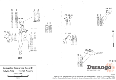
The following historical samples are summarized in an evaluation report prepared for Comaplex Resources Corporation following a drilling, geophysical, and surface sampling program in 1980 (1). Pit dimensions are summarized in Table 1. Historical assay results for the most significant pits are shown below in their entirety in Table 2a and 2b, with a map of the trench locations shown in Figure 1. All samples from the trenches were recorded as grab samples. No significant work has been reported on the property since this program.

Table 1. Dimensions of significant historical trenches

Trench Length (m) # of samples taken Remarks
Pit #1 (main) 14.6 17 Main section of Pit 1
Pit #1 (north extension) 7.1 10 Northern extension of Pit 1
Pit #2 7.4 7
Pit #6 7.8 4
Pit #7 8.4 11

Table 2a. Historical samples from the Dianna Lake property (arranged in order of Ag content)

Pit #1 (Main) Pit #1 (North) Pit #2
Ag (oz/t) % Cu Ag (oz/t) % Cu Ag (oz/t) % Cu
2458.4 336.0 0.05 298.0 0.46
684.4 0.05 225.5 0.14 197.0 0.65
647.4 9.8 0.17 20.4 0.77
600.2 6.0 0.31 20.4 0.02
464.6 0.10 4.1 0.42 16.2 0.26
454.8 3.6 0.36 14.2 0.36
407.2 0.01 3.4 4.92 12.2 0.46
405.4 2.8 0.73
383.4 1.5 0.43
321.0 1.2 0.43
242.6 0.02
240.5
185.0 0.02
56.4
31.0 0.10
17.0 0.02
16.7 0.02

Table 2b. Historical samples from the Dianna Lake property (arranged in order of Ag content)

Pit #6 (Main) Pit #7 (North)
Ag (oz/t) % Cu Ag (oz/t) % Cu
54.6 0.1 8.4 0.19
45.1 0.04 5.0 4.92
18.2 0.05 4.7 2.35
11.1 0.19 3.1 1.15
1.6 0.19 2.6 5.87
2.6 1.18
2.4 1.95
2.3 1.06
2.1 0.62
1.9 0.94
1.5 0.48

(The Company cautions that grab samples are selective and may not be representative of the mineralization on the property.)

Figure 1. Trench locations and historical assays


Click Image To View Full Size

Larger image available at: http://www.durangoresourcesinc.com/dianna-lake-silver-saskatchewan/

About the Dianna Lake Silver Prospect

Durango’s Dianna Lake Silver Prospect covers a historical area in which, from 1968 to 1969, two high-grade, primarily native silver-bearing exploration targets of between 30,000 and 50,000 tonnes grading five to 10 ounces per ton silver, approximately 600 metres apart, were determined by trench grab sample assays, according to a historical evaluation report composed for Comaplex Resources in 1980(1) *.

* Potential quantities and grades are conceptual in nature. There has been insufficient exploration to define a mineral resource and it is uncertain if further exploration will result in the target being delineated as a mineral resource.

Additionally, the main silver-bearing zone is spatially associated with a large zone of low-grade, disseminated copper-silver mineralization in which “drilling of two IP anomalies indicated approximately five million tonnes averaging 0.4 ounce per ton Ag and 0.4 per cent Cu” (undefined category historical resource estimate), according to the same report (1) **.

** A qualified person has not done sufficient work to classify the historical estimate as current mineral resources or mineral reserves and the issuer is not treating the historical estimate as current mineral resources or reserves. Further work must be carried out to verify all historical information before a resource estimate is possible.

Fourteen additional induced polarization anomalies in the historical exploration area surrounding Dianna Lake and the nearby Doug Lake remain yet undrilled, according to the Comaplex Resources report (1), four of which occur within the property boundary of Durango’s Dianna Lake silver project.

Previous work on the claims was reported in 1969, 1980 and 1998 and included diamond drill holes, trenches, and pits primarily across two zones where mineralization was identified at or near surface. One zone was reported to have five trenches exposing Ag-Cu mineralization over approximately 80 metres. Historical grab samples from Pit 1 of this zone included ounce-per-ton silver values of 2,458.4, 684.4, 647.4, 600.2, 464.2, and 454.8 ounces per ton Ag. Out of 18 grab samples, 13 samples assayed between 185.0 and 2,458.4 ounces per ton. Pit 2 grab samples returned reported highs of 298.0 and 197.0 ounce per ton Ag (out of seven samples ranging from 12.2 to 298.0 ounces per ton Ag) (1). (The Company cautions that grab samples are selective and may not be representative of the mineralization on the property.)

The technical contents of this release were approved by Mr. Case Lewis, P.Geo., a qualified person as defined by National Instrument 43-101. The property has not been the subject of a National Instrument 43-101 report.

References

  1. (1)”Evaluation report of the Dianna Lake silver-copper property, CBS 3141, S-97735 and S-97736, Uranium City area, Saskatchewan, Canada, for Comaplex Resources International Ltd.” E.G. Kennedy, PEng, 1980.

About Durango Resources Inc.

Durango is a natural resources company engaged in the acquisition and exploration of mineral properties. The Company has a 100% interest in the Mayner’s Fortune and Smith Island limestone properties in northwest British Columbia, the Decouverte and Trove gold properties in the Abitibi Region of Quebec, and the NMX East, Lac Noirs, Montagne North and Boomerang lithium properties near the Whabouchi mine, the Buckshot graphite property near the Miller Mine in Quebec, the Whitney Northwest property near the Lake Shore Gold and Goldcorp joint venture in Ontario, as well as three sets of claims in the Labrador nickel corridor.

For further information on Durango, please refer to its website and its SEDAR profile at www.sedar.com.

Marcy Kiesman, Chief Executive Officer

Telephone: 604.428.2900 or 604.339.2243

Facsimile: 888.266.3983

Email: [email protected]

Website: www.durangoresourcesinc.com

Forward-Looking Statements

This document may contain or refer to forward-looking information based on current expectations, including, but not limited to future exploration or project development programs and the impact on the Company of these events. Forward-looking information is subject to significant risks and uncertainties, as actual results may differ materially from forecasted results. Forward-looking information is provided as of the date hereof and we assume no responsibility to update or revise them to reflect new events or circumstances. For a detailed list of risks and uncertainties relating to Durango, please refer to the Company’s prospectus filed on its SEDAR profile at www.sedar.com.

Neither TSX Venture Exchange nor its Regulation Services Provider (as that term is defined in the policies of the TSX Venture Exchange) accepts responsibility for the adequacy or accuracy of this release.

INTERVIEW: Liberty Star Discusses Hay Mountain Gold Anomaly $LBSR.us

Posted by AGORACOM-JC at 12:08 PM on Monday, July 11th, 2016

  • Company controls properties which are located over what management considers some of North America’s richest mineralized regions for copper, gold, silver, molybdenum (moly), and uranium.

Hub On AGORACOM / Corporate Profile / Watch Interview

Explor Closes a Private Placement of Unsecured Convertible Debentures $EXS.ca

Posted by AGORACOM-JC at 3:37 PM on Tuesday, July 5th, 2016

Exs_logo

  • Closed a non-brokered private placement of $1,200,000
  • Each Warrant included in a Unit will allow the subscriber to purchase one common share of the Corporation at an exercise price of $0.20 for a period of two years ending July 5, 2018

ROUYN-NORANDA, QUEBEC–(July 5, 2016) – Explor Resources Inc. (“Explor” or the “Corporation“) (TSX VENTURE:EXS)(OTCQX:EXSFF)(FRANKFURT:E1H1)(BERLIN:E1H1) announces that it has closed a non-brokered private placement of $1,200,000 (the “Placement”). The Placement consists of an amount of 1,200 units at a price of $1,000 per Unit (the “Units“), each Unit consisting of a capital amount of $1,000 of unsecured convertible debentures (the “Debentures“) and of 3,333 common share purchase warrants of the Corporation (the “Warrants“). The Debentures bear interest at an annual rate of 7% and expire in two years from the closing of the Placement. Each holder of Debentures will be entitled to convert the principal amount of the Debentures in common shares of the Corporation, at a price of $0.15 per share. Each Warrant included in a Unit will allow the subscriber to purchase one common share of the Corporation at an exercise price of $0.20 for a period of two years ending July 5, 2018. Therefore, the Corporation will reserve an aggregate number of 8,000,000 common shares of its capital stock in the event of the conversion of the full principal amount of the Debentures and an aggregate number of 4,000,000 of its capital stock in the event of the exercise of all the Warrants.

One insider of the Corporation has subscribed for 50% of the Placement and will now hold 16% of the outstanding shares of the Corporation, taking into consideration the conversion of the Debentures and exercise of the Warrants.

In connection with the Placement, a total of 280,000 non-transferrable warrants will be issued to Finders dealing at arm’s length with the Corporation. Each warrant will be exercisable at $0.15 per common share of Explor for two (2) years from the closing date of the Placement.

The Debentures and any shares that may be issued on conversion of the Debentures, as well as the shares that could be issued on exercise of the Warrants and of the finders’ warrants are subject to a hold period of four months and one day, expiring November 6, 2016.

The Placement is subject to the final approval of the TSX Venture Exchange.

Issuance of Shares for Services to Agora

Explor Resources also announces that pursuant to the terms of an agreement announced on April 6, 2016 with Agora Internet Relations Corp. (“AGORA“), the Corporation will issue 80,714 common shares at a deemed price of $0.14 per share to AGORA for services rendered for the period ending July 1st, 2016, in the amount of $11,300, as scheduled in the agreement.

The common shares to be issued upon this agreement will be subject to a hold period of four months and one day from the date of issuance. The issuance of shares for Advertising Services by AGORA is subject to TSX Venture approval.

Explor Resources Inc. is a publicly listed company trading on the TSX Venture (EXS), on the OTCQX (EXSFF) and on the Frankfurt and Berlin Stock Exchanges (E1H1).

This Press Release was prepared by Explor. Neither the TSX Venture Exchange nor its Regulation Services Provider (as that term is defined in the Policies of the TSX Venture Exchange) has reviewed or accepts responsibility for the adequacy or accuracy of this release.

About Explor Resources Inc.

Explor Resources Inc. is a Canadian-based natural resources company with mineral holdings in Ontario, Québec, Saskatchewan and New Brunswick. Explor is currently focused on exploration in the Abitibi Greenstone Belt. The belt is found in both provinces of Ontario and Québec with approximately 33% in Ontario and 67% in Québec. The Belt has produced in excess of 180,000,000 ounces of gold and 450,000,000 tonnes of cu-zn ore over the last 100 years. The Corporation was continued under the laws of Alberta in 1986 and has had its main office in Québec since 2006.

Explor Resources’ Flagship project is the Timmins Porcupine West (TPW) Project located in the Porcupine mining camp, in the Province of Ontario. Teck Resources Limited is currently conducting an exploration program as part of an earn-in on the TPW property. The TPW mineral resource (Press Release dated August 27, 2013) includes the following:

Open Pit Mineral Resources at a 0.30 g/t Au cut-off grade are as follows:

Indicated: 213,000 oz (4,283,000 tonnes at 1.55 g/t Au)
Inferred: 77,000 oz (1,140,000 tonnes at 2.09 g/t Au)

Underground Mineral Resources at a 1.70 g/t Au cut-off grade are as follows:

Indicated: 396,000 oz (4,420,000 tonnes at 2.79 g/t Au)
Inferred: 393,000 oz (5,185,000 tonnes at 2.36 g/t Au)

This document may contain forward-looking statements relating to Explor’s operations or to the environment in which it operates. Such statements are based on operations, estimates, forecasts and projections. They are not guarantees of future performance and involve risks and uncertainties that are difficult to predict and may be beyond Explor’s control. A number of important factors could cause actual outcomes and results to differ materially from those expressed in forward-looking statements, including those set forth in other public filling. In addition, such statements relate to the date on which they are made. Consequently, undue reliance should not be placed on such forward-looking statements. Explor disclaims any intention or obligation to update or revise any forward-looking statements, whether as a result of new information, future events or otherwise, save and except as may be required by applicable securities laws.

Christian Dupont, President
888-997-4630 or 819-797-4630
819-797-6050
www.explorresources.com
[email protected]

Durango Plans to Explore Silver Prospect $DGO.ca

Posted by AGORACOM-JC at 10:33 AM on Wednesday, June 29th, 2016

Logo

  • Company has engaged its exploration team and is evaluating logistics for a sampling program on its wholly owned Dianna Lake Silver property located in northern Saskatchewan.
  • Marcy Kiesman, CEO of Durango, comments, “Durango is fortunate to have multiple properties positioned for discovery in its portfolio. With silver poised to be a top performing commodity for 2016, it is an exciting opportunity to explore an historic high grade project coupled with today’s new technology.”

Vancouver, BC / June 29, 2016 – Durango Resources Inc. (TSX.V-DGO), (the “Company” or “Durango”) announces that further to the news releases of March 22 and April 21,2016, the Company has engaged its exploration team and is evaluating logistics for a sampling program on its wholly owned Dianna Lake Silver property located in northern Saskatchewan.

Marcy Kiesman, CEO of Durango, comments, “Durango is fortunate to have multiple properties positioned for discovery in its portfolio. With silver poised to be a top performing commodity for 2016, it is an exciting opportunity to explore an historic high grade project coupled with today’s new technology.”

Additional details about the Dianna Lake property are on the website.

About Durango

Durango is a natural resources company engaged in the acquisition and exploration of mineral properties. The Company has a 100% interest in the Mayner’s Fortune and Smith Island limestone properties in northwest British Columbia, the Decouverte and Trove gold properties in the Abitibi Region of Quebec, and certain lithium properties near the Whabouchi mine, the Buckshot graphite property near the Miller Mine in Quebec, the Dianna Lake silver project in northern Saskatchewan, the Whitney Northwest property near the Lake Shore Gold and Goldcorp joint venture in Ontario, as well as three sets of claims in the Labrador nickel corridor.

For further information on Durango, please refer to its SEDAR profile at www.sedar.com.

Marcy Kiesman, Chief Executive Officer

Telephone: 604.428.2900 or 604.339.2243

Facsimile: 888.266.3983

Email: [email protected]

Website: www.durangoresourcesinc.com

Forward-Looking Statements

This document may contain or refer to forward-looking information based on current expectations, including, but not limited to the purchase, development, completion of financing, commencement and completion of future exploration or project development programs and the impact on the Company of these events. Forward-looking information is subject to significant risks and uncertainties, as actual results may differ materially from forecasted results. Forward-looking information is provided as of the date hereof and we assume no responsibility to update or revise them to reflect new events or circumstances. For a detailed list of risks and uncertainties relating to Durango, please refer to the Company’s prospectus filed on its SEDAR profile at www.sedar.com.

Neither TSX Venture Exchange nor its Regulation Services Provider (as that term is defined in the policies of the TSX Venture Exchange) accepts responsibility for the adequacy or accuracy of this release.

FEATURE: Explor Resources (EXS: TSX-V) 609K oz Indicated / 470K oz Inferred Gold $EXS.ca

Posted by AGORACOM-JC at 5:10 PM on Friday, June 24th, 2016

Why Explor Resources?

  • Flagship Property Offers The Following:
  • NI 43-101 Resource – 609,000 oz Indicated / 470,000 Inferred
  • Teck Resources To Spend $12 MILLION To Earn 70%
  • Property Is 2.5 KM From Lake Shore Gold Mine
  • Property Is 13 KM From Downtown Timmins
  • 2nd Project 43-101 Open Pit Resource
  • 1.4 MILLION T Indicated @ 1.38% Copper
  • 2.09 MILLION T Inferred @ 1.26% Copper

ONTARIO AND NEW BRUNSWICK PROPERTIES CURRENTLY UNDER EXPLORATION

Timmins Porcupine West (TPW) (4300 ha)

  • NI 43-101 Resource: 609,000 oz Indicated
    470,000 oz Inferred Gold
  • 13 km from downtown Timmins
  • Property is 2.5 km, NE of LSG West Timmins Mine
  • Model: Hollinger McIntyre Gold System: 30,000,000 oz. Au
  • Discovery Hole 10-30 : 9.22g/tonne over 11.0 meters
  • Optioned to Teck Resources
  • Teck to spend $12,000,000 to earn 70% interest

Chester Copper & VMS Project (3500ha)

  • Mineral Target: Cu, Pb, Zn, Ag, & Au
  • 70 km SW of Bathurst NB
  • Structural Model Complete
  • 300 m wide x 2000m long mineralized Corridor identified
  • Ramp to ore zone (480 meter long (3m x 4m)
  • Optioned to Brunswick Resources (BRU)
  • Brunswick to spend $500,000 over 3 years
  • Explore to receive $40,000 and 5,000,000 shares of BRU
  • Open pit resource – NI 43-101 Resource: 1,400,000 Indicated t @ 1.38% Cu
    2,089,000 Inferred t @ 1.26 % Cu


Kidd Creek Project (2466 ha)

  • Mineral Target: Cu-Zn Ore
  • Located 1.0 km west of Kidd Creek Mine
  • Kidd Mine yielded 130M tonnes of Cu-Zn Ore since 1960
  • Numerous Geophysical max/min and IP Targets
  • Diamond Drilling winter 2015/2016

QUEBEC PROPERTIES CURRENTLY UNDER EXPLORATION

East Bay (3203 ha):

  • Mineral Target: Gold
  • Lies on Porcupine Destor Fault Zone, on strike with Beattie & Donchester mine
  • Historical channel samples by Lacana Mining in 1982 including: 0.81 oz/ton over 5ft; 0.16 oz/ton over 6 ft; 0.10 oz/ton over 10 ft
  • Wrap around Clifton Star

Nelligan (1198 ha):

  • Mineral Target: Nickel
  • Located in Val d’Or mining district of Quebec
  • Historical grab samples of 10% Ni and 0.6% Cu obtained by INCO
  • Discovered anomalous Nickel, Copper Zones

Launay (2250 ha):

  • Mineral Target: Nickel
  • Mineralized zones contained in mafic volcanic rocks
  • Contiguous to Royal Nickel’s Dumont property (NW end)

12 Month Chart

Â