Agoracom Blog Home

Posts Tagged ‘gold’

Uragold Commences 3D Modeling Of Golden Hope’s Bellechasse-Timmins Gold Deposit

Posted by AGORACOM-JC at 9:39 AM on Wednesday, February 25th, 2015

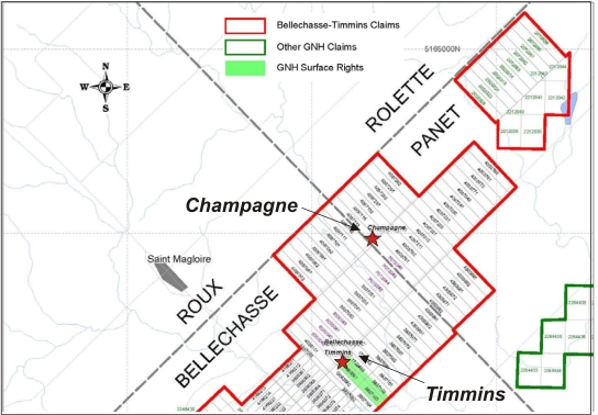
Montreal, Quebec / February 25 2015 – Uragold Bay Resources Inc. (“Uragold”) (TSX Venture: UBR) is pleased to provide its shareholders and stakeholders an update regarding its ongoing work program on its option with Golden Hope on the Bellechase-Timminnins (“BT”) gold deposit, located near Saint-Magloire in the Beauce region of Southeastern Quebec.

To complete its goal of acquiring all of the required permits needed to do a rolling start open pit operation on the BT gold deposit, Uragold had to first compile all available data in order to complete a new NI 43-101 resource estimate. Regulatory rules dictate that Uragold must treat all information from Golden Hope’s NI 43-101 technical report published in June 2012 as historical information until such time that Uragold’s technical team has independently validated the data.

In order to complete this, Uragold needed to build a completely new 3D geological model for the T1 and T2 surface zones of BT, to be then able to develop its own independent assay grade shells.

Uragold has acquired a license for the Leapfrog 3D Modeling package. The 3D Model created by the company’s technical team will allow Uragold to evaluate new gold grade shells. Uragold is also planning a re-sampling/assay program to validate all historical data for a new NI 43-101 resource estimate on the T1 and T2 Zones.

Once completed, Uragold can move forward with the creation of a Feasibility Study, as required by the new Mining Act, and to finalize the permitting process for a rolling start open pit gold mining operation.


Click Image To View Full Size

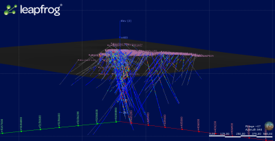
Figure 1. This figure shows the drill holes entered into the initial database with associated gold values. The dark surface is the underside of the topography and the associated pink haze is created by the borehole number/ nametags. The view is northeast looking slightly upward through the borehole cluster. The closest cluster of holes is the T1 diorite. Maximum depth of the boreholes is around 600 metres.

The database still requires the addition of several sets of borehole data; surface trenching data (the trench data is currently being added), and potentially other data not yet identified.

As can be seen from Figure 1, there are numerous boreholes (to the left of centre) that are grey coloured. These are known boreholes from a previous drill campaign by Osisko (2003-04), for which no assay data is available nor has it been added to the database (not sampled/ not assayed/ etc.). The assay colouring scale is arbitrary but warm colours (red/ yellow/ orange) are higher gold grades than cooler colours (green/ blue). Considerable trench data is available and will be added.

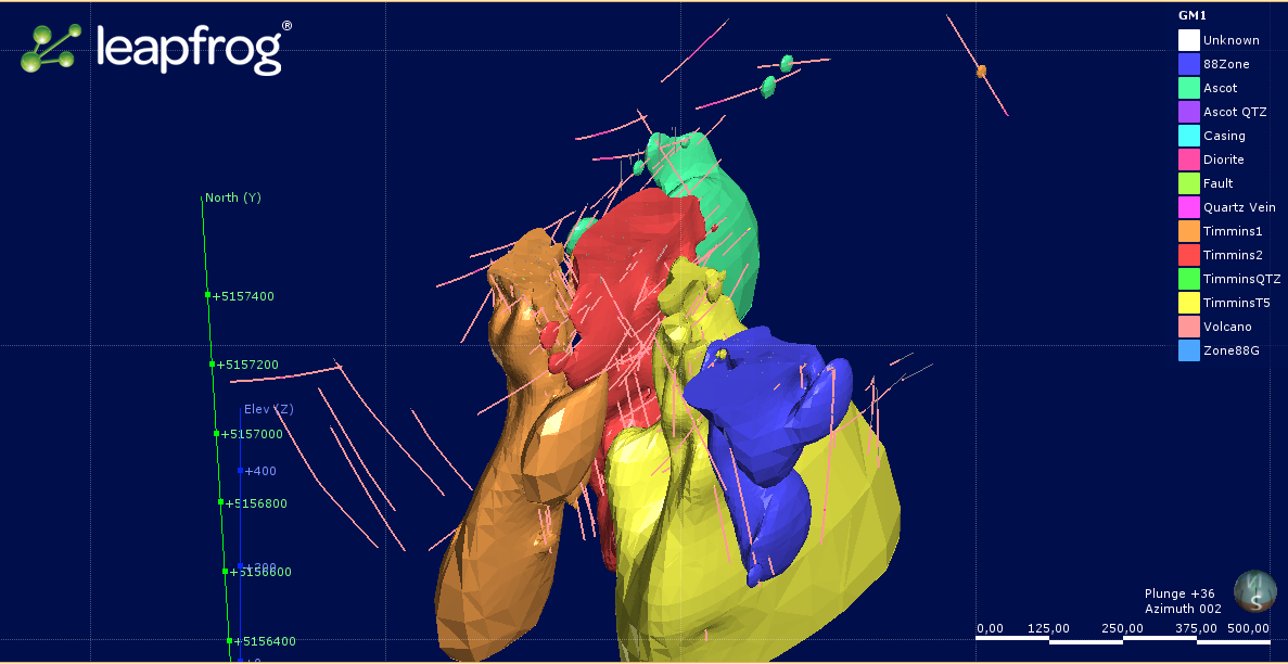
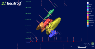
Figure 2 shows what the model looks like when the interpretive lithology data is utilized. At the time of core logging, Golden Hope’s staff identified numerous gold hosting diorite types and categorized these individual units into named types. This version of the Leapfrog model has constructed “shells” that incorporate most of each named subset of diorite.


Click Image To View Full Size

Figure 2. This diagram shows the Timmins1 body (T1 – left hand body); the Timmins2 (T2 – red/ brown body); the Timmins5 body (T5 – yellow body); the Ascot body (green-blue at the back); and the Z88 body (dark blue right foreground). The view is looking downward onto the bodies very slightly east of north.

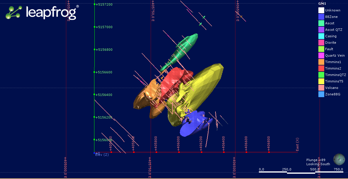
The shape of these bodies is very dependent on the initial logging and the reader is reminded again that this is a preliminary model. However the vertical nature of the diorite bodies and their tendency to parallel the regional stratigraphy and strike (northeast and close to vertical) is very apparent. This is particularly well seen in Figure 3.


Click Image To View Full Size

Figure 3. This image shows the BT diorite bodies from overhead. In this image it becomes very clear that the regional strike and dip (northeast and close to vertical) had a very strong controlling influence on the development of the dioritic bodies. It is very apparent that they intruded at a stage when the surrounding sediments were still relatively easily deformed and yet dominantly in a vertical position.

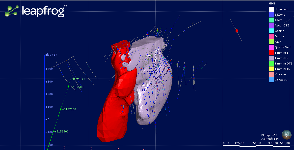
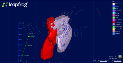
The Leapfrog package can also be used to develop assay grade shells.


Click Image To View Full Size

Figure 4 is generated on an arbitrary grade shell that was used to test the modelling data. This Figure shows the T1 (red) and T2 grade shells. These are preliminary and the shape will almost certainly change in later versions.

By using the Leapfrog software to develop a new block model, it should be possible to generate updated resource figures and grades. The block model uses several control parameters that still need to be determined as part of the modelling program.

Patrick Levasseur, President and COO of Uragold stated, “Golden Hope has done a tremendous job in demonstrating the gold potential at Bellechase-Timmins. We are excited to further develop these resources. We look forward to confirming the potential with an updated gold resource estimate.”

Mr. Vivian Stuart-Williams, SACNASPS, working under Special Authorization #308 of the Quebec Order of Geologist, is an Independent Qualified Person as defined by National Instrument 43-101 that supervised the preparation of the information in this news release.

All the information on exploration potential herewithin presented is historical in nature and while relevant, the information was obtained before the implementation of National Instrument 43-101 and as such does not meet National Instrument 43-101 reporting standards. The historical estimate should not be relied upon until the Company can confirm them.

About Golden Hope Mines Option

In April 2014, Uragold singed a definitive option agreement with Golden Hope Mines (“GNH”) concerning the advancement of the Bellechasse-Timmins (BT) Gold Deposit into a producing mine.

In August 2012, GNH published a resource estimate of an indicated resource of 313,900 ounces gold (2.9 million tonnes grading 3.36 g/t Au) and an inferred resource of 102,000 ounces gold (2.17 million tonnes grading 1.46 g/t Au) using a cut-off grade of 0.60 g/t. Furthermore, GNH’s many bulk-sampling campaigns revealed extensive areas of surface mineralization averaging approximately 3 g/t Au. Notable were sampled areas averaging up to 10 g/t Au (Trench 09A).

With its Beauce Placer project, Uragold intends to develop a (600 MT/day) surface gold mining operation on the B-T property. Developing in parallel the B-T property and the Beauce Placer property will benefit both companies by providing greater geological and operational synergies such as cost savings.

Under the terms of the Option Agreement, Uragold will be responsible for obtaining all required permits, approvals, and documentation associated with going into production, in return for a 30% interest in the property. Uragold will then have 120 days to obtain project financing, which, if successful, will earn it a further 20% interest, giving Uragold a 50% interest in the B-T deposit. The companies will then form a Joint Venture (JV) for the operation of the mine, with Uragold serving as operator. GNH will have a carried interest into production, and will receive a 50% Net Proceeds Royalty (“NPR”) on the gold produced.

Other Corporate developments:

Uragold (Quebec Quartz) is expanding its holdings over the Martinville silica property to 12 claims, with the purchase from a private vendor of 8 adjacent claims. As consideration for the transaction and subject to regulatory approval, the Corporation will be acquiring 100% of the 8 claims that will constitute the New Martinville silica property through the issuance of 400,000 units. Each Unit is comprised of one (1) common share and one (1) common share purchase warrant (“Warrant”) of the Company. Each Warrant will entitle the holder thereof to purchase one common share of the capital stock of the Company at an exercise price of $ 0.07 during a period of 36 months from the date of closing of the placement. Each share issued pursuant to the placement will have a mandatory four (4) month holding period from the date of closing of the placement.

About Uragold Bay Resources Inc.

Uragold Bay Resources is a TSX-V listed Gold and High Purity Quartz exploration junior focused on generating free cash flow from mining operations. Our business model is centered on developing mining projects suited for smaller-scale start-up, (Capex < C$10M), that will generate high yield returns (IRR > 50%). Uragold will reach these goals by developing Quebec’s first placer mine in 50 years, the Beauce Placer Project developing and, in partnership with Golden Hope Mines, the Bellechasse-Timmins Gold Deposit.

Neither the TSX Venture Exchange nor its Regulation Services Provider (as that term is defined in the policies of the TSX Venture Exchange) accepts responsibility for the adequacy or accuracy of this release.

For further information contact

Bernard J. Tourillon, Chairman and CEO
Patrick Levasseur, President and COO

Tel: (514) 846-3271

www.uragold.com

Hay Mountain Project Update: Added Targets, New Discoveries, and Innovative In-Hole Assay Done While the Drill Turns

Posted by AGORACOM-JC at 10:41 AM on Tuesday, February 24th, 2015

Liberty Star Uranium & Metals Corp. (“Liberty Star” or the “Company”) (OTCQB: LBSR) is pleased to announce that three technical breakthroughs have occurred at the Hay Mountain Project over the last three months. These are:

1. Additional targets

2. The potential for leachable oxide copper bodies

3. The ability to separate diamond core drill cuttings using a centrifuge so that cuttings can be separated into samples corresponding to drill core intervals or fractions of those intervals at any depth desired as the drill turns without waiting for the core to be removed from the hole. Then x-ray fluoresce analyzers will be used to analyze these samples for an approximate assay in the field as the drill turns.

Liberty Star’s CEO/Chief Geologist elaborates point by point:

1. “Working with geologist Dr. S. Skirvin using geologic information systems (GIS) mapping tools, we clarified the geophysical relationships so that the geophysical data (ZTEM- electromagnetics and magnetics) for the Hay Mountain Project area could be related to culture on topographic maps, and recently produced high resolution space imagery, leading to the detection of significant number of additional targets

2. “We have also evaluated the surrounding copper and precious metal mines including Arizona’s Tombstone, Bisbee (historic and future Cochise ore body), Johnson Camp, I-10 Porphyry Gunnison- Excelsior, Safford, Morenci, Rosemont, Florence, Twin Buttes: New Mexico’s Tyrone mine, Mexico’s La Caridad, and Cananea, and many others, which all have oxide copper recovery units (Solvent Extraction-Electrowinning plants (SX-EW plants)). Most porphyry copper deposits in the southwest USA, Mexico, Latin America and other geologically similar areas have a green and black copper oxide cap or periphery as a result of their oxidizing history details dependent on rock type and other factors. Hay Mountain is easily compared to Bisbee, Nord Resources Corporation’s Johnson Camp and the Gunnison Copper Project (Excelsior Mining Corp), nearby where the same package of layered altered and mineralized rocks exists, as does a profound magnetic anomaly (Gunnison and Hay Mountain and others). Gunnison has disseminated oxides that can be treated by in situ (Latin: in place) leaching. Excelsior has done extensive testing and design of a proposed in situ leach operation that suggests an internal rate of return of about 45% and a payback in 2.5 years using a projected $2.75 copper price. (Pg. 246 Gunnison Copper Project: NI 43-101 Technical Report Prefeasibility Study). We have encountered more shallow outcrops containing green and what appears to be black copper oxide at Hay Mountain. Also, the horizontal tops of the recorded magnetic signals suggest the top of an oxide zone that compels us to consider that a large, near surface body of oxide copper may be located above the large sulfide targets which are more easily detected by ZTEM (electromagnetic, and magnetic) geophysics. The same host rock sediments are present at Johnson Camp, Gunnison, Bisbee and Hay Mountain. These rocks can be selectively mined using a Vermeer Terrain Leveler, resulting in lower cost mining and ore grade selection than standard methods of open pit mining. I have already had tests run at the Vermeer laboratories on ore material of each of the various sedimentary copper bearing units at Johnson Camp to see if the Vermeer can cut these altered and mineralized sediments. The results demonstrate that the Vermeer machinery can readily cut these units. Contacts between low and high grade can be followed to within 6 inches horizontal and a couple of inches vertically. Fragmentation achieved by the Vermeer concentrates on the ore bearing interstices of the host rock, thus maximizing the proportion of exposed surface area of the fragmented material that is ore bearing. This feature yields materials that may be much more available for solvent dissolution than conventionally crushed ore. The cut can be adjusted to get the optimum fragment size for heap leaching: all of this without using drilling or blasting. Thus, if we intersect significant amounts of leachable oxide copper mineralization at a shallow depth, which, as stated above, all surrounding porphyry copper mines have, we will immediately go into an evaluation mode. Nothing is definite until drills define such an oxide mineral body, but these types of deposits could go into production at a low cost, and quickly: in the range of 4 years (See pg. 249 Excelsior’s 43-101). The mining method at Hay Mountain could be open pit, heap leach or in situ like that planned at the Gunnison Copper Project.

3. “We will be using some advanced equipment in the drilling program which will make Phase 1 drilling proceed faster, more controlled, accomplished more accurately, and data gathered very quickly. This will be a Solids Removal Unit (SRU), developed by an Australian company and sold in the USA (see http://www.amcmud.com/en/products-range/equipment-rental/product-data-sheets.html).

i. This device uses a centrifuge to remove drill cuttings from the mud circulation that cools the diamond bit and carries cuttings to the surface.

ii. The SRU removes +99% of drill cuttings from the mud and then circulates the cleaned mud back down the hole.

iii. The cuttings are ejected from the SRU where they can be bagged and disposed of.

iv. This give us the opportunity to sample the drill cuttings at any interval we choose – say 2.5, 5, 7.5 or 10 feet – or all of those intervals through the length of the drill hole or whatever intervals are desired to determine what the diamond drill is cutting even before the core is extracted, by “assaying” using a modern XRF (X-Ray fluorescence) unit:www.niton.com either a hand held “gun” or a more powerful bench or pick-up tail gate style unit. While an XRF is not a true “assay” used for exact grade determination for ore calculations it is sufficient for the onsite geologist to determine whether the gross metals content is going up, down or remaining the same. This information can be transmitted by computer to the Internet so all senior management personnel can review the data if it is critical. Standard drill core assays by a certified lab will still be undertaken following standard procedures which can only be done that involve a carefully monitored and controlled half sample split of the drill core, prepared in a very clean sample prep lab, and sent under chain of custody control to a certified lab, which we will also do. However XRF is sufficient for the onsite geologist to determine whether the gross metals content is going up, down or remaining the same. This droll mud sampling methodology (but without the use of the SRU) was reported by D.K.F. McLachlan, in Mckinstry,H.E. – Mining Geology 1948 in the days when diamond drilling was young and the diamond drill core bit tended to grind up core that was soft, where the mineralized intervals were encountered. It is still a valid technique when combined with the SRU.

“The SRU also meets the requirements of the Arizona State Land Department permits that require collection of drill cuttings and disposal in permitted land fill.

All of this new data and our innovative techniques, as well many other details will be used in the presentation in Manila, Philippines March 2-3, 2015 by Director Brett Gross and myself during a full day presentation to potential investors and mining professionals.”

“James A. Briscoe” James A. Briscoe, Professional Geologist, AZ CA
CEO/Chief Geologist
Liberty Star Uranium & Metals Corp.

Forward Looking Statements

Statements in this news release that are not historical are forward looking statements. Forward-looking statements in this news release include all our planned drilling program, planned methodology and our planned use of equipment, partners or funding sources, including without limitation our plan to commence Phase 1 drilling at Hay Mountain and define an economic body of mineralization there; that geological conditions may allow for an in situ leaching operation, or open pit heap leaching; that discovery of such a leachable ore body, similar those enumerated above, could result in a 4 year time line to production. Factors which may delay or prevent these forward-looking statements from being realized include: the failure of our proposals to be accepted; we may not attract any partners or funding sources; we may not be able to raise sufficient funds to complete our intended exploration, keep our properties or carry on operations; and we may encounter an inability to continue exploration due to weather, logistical problems, labor or equipment problems or hazards even if funds are available. Even if we find a partner, we may not be able to reach agreement or carry out the development program as contemplated. Despite encouraging data there may be no commercially exploitable mineralization on our properties. Readers should refer to the risk disclosures in the Company’s recent 10-K and the Company’s other periodic reports filed from time to time with the Securities and Exchange Commission.

Agoracom Investor Relations
[email protected]
http://agoracom.com/ir/libertystar
or
Liberty Star Uranium & Metals Corp.
Tracy Myers, 520-425-1433
Investor Relations
[email protected]
Follow Liberty Star Uranium & Metals Corp. on Facebook , LinkedIn & Twitter@LibertyStarLBSR

Liberty Star Announces Statement by CEO/Chief Geologist James A. Briscoe and Update in Travel Plans

Posted by AGORACOM-JC at 9:26 AM on Wednesday, February 18th, 2015

TUCSON, Ariz., Feb 18, 2015 — Liberty Star Uranium & Metals Corp. (“Liberty Star” or the “Company”) (OTCQB: LBSR), which holds 100% interests in the Company’s premier exploration property for porphyry copper, gold and associated commercial metals, The Hay Mountain Project (southeast Arizona – Cochise County), is pleased to announce a shareholder update and comments from the CEO. Additionally, new travel arrangements have been set: Mr. Briscoe and Director Brett Gross depart for Manila, Philippines, February 26th to meet a group of mining professionals introduced to the Company by a long-time Liberty Star shareholder, mining engineer and investor, in an all-day meeting on Monday, March 2, 2015. The pair plan to make multiple in-depth presentations to an audience of potential investors that have signed binding non-compete/non-disclosure agreements. The naseba roadshow announced in NR 193 has been postponed.

James A. Briscoe, Chairman, CEO and Chief Geologist, offers the following update and comments:

“At this time I feel it is important to reaffirm our goals for the Hay Mountain Project and the company at large. The financing of our yearlong Phase 1 drilling program at our Hay Mountain Project remains priority one. I plan to travel to Manila, Philippines, to meet sophisticated potential investors with this goal in mind. We were scheduled to travel to the Middle East for a roadshow sponsored by naseba/Naru Capital, but events there and ensuing turmoil have intervened and I and the board of directors have decided that I should not travel to the area until security issues have been resolved. I have arranged with Naru/naseba to undertake teleconference meetings with appropriate candidates from the Middle East area for now. While Hong Kong was on the agenda and is a good venue, we will have to put it off until more contacts have been made.

“Let me go over some of the financial realities we are operating under right now that have impacted the Company. Natural resource prices have hit multiyear lows which have turned investment not only away from our efforts, but the industry at large. I invite you to look at the stock trading charts of any exploration or mining company and you will see red ink everywhere. I believe this will not last long term and that copper and gold prices must go up: if not immediately, the trend must return to conform to the global demand for resources that is widely acknowledged. While I am in no position to take responsibility for this mega-trend knowledge, I do intend to capitalize on it for shareholders when negotiating with potential investors in Hay Mountain. Right now the cost of exploration is depressed: it will be a sage partner who will enter the market at its very lowest and understands the adage ‘buy low, sell high’ and understands the supercycle for metal prices, especially copper (see Don’t Get Hung Up on Short-term Copper Prices: Lawrence Roulston, Jan 22, 2015).

“I also want to address questions that have come to my attention:

“Question 1: Is a reverse split under consideration? I am not considering this option at this time. Even if I did decide to reverse split because of a new regulatory requirement or other unforeseen reason, I would first seek approval of the shareholders to increase the authorized capital, and there would be prior notice through our filings with the SEC. When we progress to the drilling stage and as the copper price rises, as it always does and will again, I believe our fortunes will rise as well, and a rollback will have seemed inconsequential.

“Question 2: Am I considering changing the Phase 1 drilling program to drilling a couple of mother holes soon, using Liberty’s funds, rather than waiting for a JV? No, I think that is not a good idea for the Company and its shareholders. My thinking stems from my experience and the history of exploration in the area. I’ve been involved in porphyry copper exploration and mining for 50 years. It was my good fortune to have worked directly for two of the world’s great ore finders and lifelong business partners, ASARCO geologists Kenyon Richard, and James Harold Courtright, respectively VP Exploration and Chief Geologist. I’ve spent many hours and days with these two mentors, who took time to review the exploration histories of the discovery of Silverbell, the Mission Mine (both in Pima County, Arizona), and many others in Arizona, Nevada, Canada, southern Peru, Mexico, the Mother Lode gold belt, California and the Mesquite and Cargo Muchacho gold mines in southeast California. I spent two intensive years working in the Silverbell mine under them where I extended and expanded the seven-year-long drill program which had about ‘six weeks’ to go on my arrival to an additional 4 years with additional drill rigs. I found with this intimate contact with a classic operating open pit porphyry copper mine that even a porphyry copper can have dead spots in it. In a study I personally set up, I determined that if Silverbell had been completely covered and had only an IP (induced polarization study and anomaly: the primary geophysical tool at the time) it would have required 21 holes spaced on a 1,000 foot grid, to be sure that one intersected ore grade material.

“To hope that ‘a hole or two’ would intersect ore is a sure road to a ‘gambler’s ruin’ and would never have been allowed under the Richard and Courtright team management. Note it took them 27 holes into the Mission target before ore grade material was cut by the diamond drills, resulting in the massive Mission Mine that has now been operating 50 years with at least 30 years left. Liberty Star will continue to pursue our careful plan that will result in a thorough and professional test of the world-class anomaly at the Hay Mountain Target 1. Remember, the Hay Mountain target is projected to be a mega multiyear exploration, development and mining project. The dimension of the geochemical and geophysical response is 4 miles long by 2 miles wide, a permissible size to contain a ‘World Class’ very large mineral deposit. The only way to determine where the hot spots are is to drill diamond drill holes to test for mineralization while confirming and honing our geophysics, geology, and geochemistry knowledge. Rather than making Phase 1 small and desperate, careful analysis sees the project expanding the possible number of viable targets and the funding requirements. One of the key attributes of Phase 1 is its economic practicality: that would be completely destroyed if a drilling rig was employed to only drill two holes because the drill and all of its men and equipment is expensive to mobilize and demobilize. Also ore grade mineralization might be missed entirely.

“Raising money is very hard in the current economic circumstances, but given recent interest the Hay Mountain Project has generated, certainly possible.

“We have serious interest from experienced mining professionals that also possess the financial means to invest in Hay Mountain and will also participate in the conceptualizing of operations there. The invitation to present in Manila came from Mr. Tomas Malihan, CEO & President of Oremet Corp., Mr. Angelito Doria, VP Civic Corp., and Mr. Alfonso Doria, Philippine mining engineer and longtime supporter and major Liberty Star shareholder. Mr. Alfonso Doria completed a 3 day trip with me to southeast Arizona copper mines surrounding Hay Mountain and then Hay Mountain, examining surface outcrops, and technical documents concerning the Hay Mountain Project. He was duly impressed with the thoroughness of the approach and indications of the presence of a large but covered metal source resulting in geochemical, alteration and geophysical indications. His report of his evaluation resulted in the above-mentioned invitation to present in Manila. In an all-day meeting at a major hotel in downtown Manila between 10 and 20 mining professionals, including mining representatives from the Philippines, China, and India, will listen to me and Mr. Brett Gross, Mining Engineer, Attorney and Liberty Star Director. I will speak extensively about the geology, geochemistry and geophysics of Hay Mountain and why they indicate a mineral body at depth. Mr. Gross will present an innovative and financially attractive proposal to them for funding Hay Mountain, Phase 1 and beyond. There will be time for detailed information transfer as well a question and answer session.

“Multiple copper and precious metal mines are underway in southern Arizona, primarily funded by Canadian junior to intermediate companies. We have now been contacted, regarding interest in Hay Mountain, by three major international mining companies that are among the world’s largest. This is indicative of the perceived quality of the Hay Mountain Project. We hope these expressions of interest generate visits to the Hay Mountain area, continued due diligence by multiple parties and the eventual signing of a joint venture agreement. This is not a quick process to undertake a large project, but it is a beginning. We are optimistic that even during this period of low metal prices we are generating genuine interest and feel optimistic that a deal or deals will be struck on Hay Mountain.”

“James A. Briscoe” James A. Briscoe, Professional Geologist, AZ CA CEO/Chief Geologist Liberty Star Uranium & Metals Corp.

Forward-Looking Statements

Statements in this news release that are not historical are forward-looking statements. Forward-looking statements in this news release include our entire planned drilling program; that mineral prices will rebound; and our planned route to access partners or funding sources. Factors which may delay or prevent these forward-looking statements from being realized include: the failure of our proposals to be accepted; we may not attract any partners or funding sources; we may not be able to raise sufficient funds to complete our intended exploration, keep our properties or carry on operations; mineral prices may not rebound in time for us to keep our properties; and we may encounter an inability to continue exploration due to weather, logistical problems, labor or equipment problems or hazards even if funds are available. Even if we find a partner, we may not be able to reach agreement or carry out the development program as contemplated. Despite encouraging data there may be no commercially exploitable mineralization on our properties. Readers should refer to the risk disclosures in the Company’s recent 10-K and the Company’s other periodic reports filed from time to time with the Securities and Exchange Commission.

http://cts.businesswire.com/ct/CT?id=bwnews&sty=20150218005211r1&sid=cmtx6&distro=nx&lang=en

SOURCE: Liberty Star Uranium & Metals Corp.

CONTACT:          

Agoracom Investor Relations [email protected] http://agoracom.com/ir/libertystar or Liberty Star Uranium & Metals Corp. Tracy Myers, 520-425-1433 Investor Relations [email protected] Follow Liberty Star Uranium & Metals Corp. on Facebook, LinkedIn & Twitter@LibertyStarLBSR

Exploration Update on Golden Hope’s Poly-metallic Massive Sulphide Champagne Deposit in the Bellechasse Belt of Southeastern Quebec

Posted by AGORACOM-JC at 8:00 AM on Wednesday, February 18th, 2015

Montreal, Quebec / February 18, 2015 / Golden Hope Mines Limited (TSX VENTURE: GNH) – Golden Hope Mines Limited (‘Golden Hope”, or “the Company”) is pleased to announce that the Institut national de la Recherche Scientifique (“INRS”) led by Marc Richer-Lafleche has submitted its report of a high resolution Audiomagnetotelluric Survey and a Petrophysical Study on the poly-metallic massive sulphide Champagne Deposit in the region of Bellechasse, Quebec. This survey and study followed a Versatile Time Domain Electromagnetic Survey (“VTEM”) that was conducted by Geotech for Golden Hope in late 2011, and confirmed the presence of a number of strong electromagnetic and magnetic anomalies within the Beauceville Formation (Magog Group) and more specifically over the known areas containing massive sulphide deposits. The Champagne sulphide mineralization appears to be a hybrid structure, possessing characteristics of both Sedimentary Exhalative Deposits (‘SEDEX”) and Volcanic-Hosted Massive Sulfide Deposits (“VMS”).

The Audiomagnetotelluric Survey was conducted with readings 25 to 50 metres (“m”) apart, and had a deep vertical penetration of 1500m. The results from the survey over the known Champagne Deposit mineralization indicate a significant sub-vertical conductor beneath the massive sulphides confirmed through previous drilling. The conductor (V) begins at approximately 240m of vertical depth and extends to approximately 650m depth with a maximum implied thickness of approximately 60m. (Figure 2.)

A second prospective conductor (IV) was indentified approximately 500m south of the Champagne Deposit, beginning at approximately 225m vertical depth and extending to an approximate depth of 880m, with a maximum implied thickness of 160m. This second conductor has been interpreted to be associated with the first conductor indicating the repetition of the sulphide target horizon through the presence of a structural fold (syncline).

As a result of this important and encouraging new interpretation of what might potentially be large tonnage poly-metallic sulphide deposits within the Champagne Belt of Southeastern Quebec. Golden Hope will develop an exploration plan to further evaluate the potential of these large geophysical targets associated with the known massive sulphide mineralization. The Company will also expand the geophysical program to determine if similar targets occur elsewhere within the Champagne Belt.

The Company’s contiguous mineral claims include approximately 10 linear kilometres of the stratigraphic horizon near the base of the Beauceville Formation that hosts the Champagne occurrence. The Champagne occurrence lies on the north limb of a synclinal fold. An additional 20 linear kilometres of the horizon is exposed within the company’s claims that cover the south limb of the syncline. The Champagne Deposit is a partially explored base and precious metal occurrence that lies entirely within the Company’s 100% owned Bellechasse Belt, on claims 3.5 kilometres north of the Company’s Bellechasse-Timmins Gold Deposit. Previous work on Champagne outlined a historic estimate of 250,000 tonnes of massive and disseminated sulphides, averaging 2.4 g/t gold, 19.7 g/t silver, 2.7% zinc, 0.40% copper and 0.45% lead (Paradis, Bosse and Gauthier, 1995 Report from the Centre Geoscientifique de Quebec, referencing Bergman (1954)). A Qualified Person as defined by National Instrument 43-101 has not done sufficient work to classify the historical estimate as a current mineral resource, nor is Golden Hope treating the historical estimate as a current mineral resource.

A copy of the INRS presentation can be found on the company’s web site at: http://goldenhopemines.com/exploration/

Marc Richer-Lafleche who is a qualified person as defined by National Instrument 43-101 and has reviewed and approved the technical contents of this press release.

Statements Regarding Forward-Looking Information

Information set forth in this news release by Golden Hope Mines Limited may contain forward-looking information within the meaning of Canadian securities laws. Forward-looking information includes statements that relate to future, not past, events. In this context, forward-looking information often addresses the Company’s expected future business and financial performance, and often contains words such as “anticipate”, “believe”, “plan”, “estimate”, “expect” and “intend”, statements that an action or event “may”, “might”, “could”, “should” or “will” be taken or occur, or other similar expressions (including negative and grammatical variations). Such information includes plans, timing and expectations for updates of the Company’s resource estimate; expectations regarding the Company’s planned exploration activities and budget; the timing for receipt of drilling and assay results; and plans for further exploration and drilling at Bellechasse-Timmins and Champagne/VMS and other targets along the Bellechasse Belt. Specifically relating to possible mining of the Bellechasse-Timmins gold deposit, the Company must obtain specific permits beyond the Certificate of Authorization; may complete additional exploration and development work; and obtain appropriate financing before mining may begin. By their nature, forward-looking information involves known and unknown risks, uncertainties and other factors which may cause the Company’s actual results, performance or achievements, or other future events, to be materially different from any future results, performance or achievements expressed or implied by such forward-looking information. Such factors include, among others, the following risks: the risks associated with any outstanding litigation; risks associated with exploration activities and project development; timing of and unexpected events regarding the receipt and interpretation of drilling and assay results; delays in the preparation of resource estimate updates; the need for additional financing; operational risks associated with mineral exploration; fluctuations in gold and other commodity prices; title matters; technical and permitting issues; environmental liability claims; insurance matters; reliance on key personnel; the potential for conflicts of interest among certain officers, directors or promoters with certain other projects; the absence of dividends; competition; dilution; the volatility of our common share price and volume; the impact of taxation; and general economic conditions. Forward-looking information is based on management’s beliefs, estimates and opinions on the date hereof and the Company undertakes no obligation to update any forward-looking information if these beliefs, estimates and opinions or other circumstances should change. Investors are cautioned against attributing undue certainty to forward-looking information.

Any historical mineral quantities set forth herein are, unless otherwise indicated, are not compliant with National Instrument 43-101.

About Golden Hope Mines Limited

Golden Hope Mines Limited is a mineral exploration company that seeks to grow shareholder value through the acquisition, exploration and development of potentially large-scale gold and base metal projects suitable for underground and/or open-pit mining. The company’s focus is in southeastern Quebec, Canada. The company’s claim blocks lie within an area that extends approximately 100 kilometres along the Appalachians of southern Quebec from near Ste-Lucie-de-Beauregard to about 16 kilometres southwest of Beauceville. The Bellechasse-Timmins gold deposit lies 5 kilometres southeast of St-Magloire within the Bellechasse Belt an approximately 18 kilometre long mineralized area. The Bellechasse-Timmins gold deposit includes the T1, T2A, T2B, Ascot/Road gold zones, and the 88 Diorite. The company is also looking to develop the Champagne zone, a partially explored base metal and gold deposit that lies within the Company’s Bellechasse Belt claims. A recently completed VTEM survey may identify other similar targets along the horizon. The company is also working to develop other targets within its claim blocks including the FSG gold and base metal target, Chute du Bras, the LG showing, Moose Cliff, and Talon.

For further information:

Golden Hope Mines Limited.

www.goldenhopemines.com

Frank Candido, Presdient, Director

Tel : 514-969-5530

[email protected]


Click Image To View Full Size

Figure 1. Location of the Champagne Deposit in relation to the Bellechasse-Timmins Gold Deposit


Click Image To View Full Size

Figure 2. The Audiomagnetotelluric Survey over the known Champagne Deposit in Bellechasse, Quebec.

Uragold Increases its Gold Exploration Potential for the Beauce Paleoplacer Project, Closes the Fancamp Claims Acquisition and Files a New NI 43-101 Technical Report

Posted by AGORACOM-JC at 11:31 AM on Thursday, January 22nd, 2015

Montreal, Quebec / January 22, 2015 / Uragold Bay Resources Inc. (“Uragold”) (TSX Venture: UBR), is pleased to announce that it has filed a new technical report in accordance with National Instrument 43-101, entitled, “Technical Report on the Beauce Paleoplacer Property, South-Eastern Quebec” (“Technical Report”) with Canadian securities regulators. The project is located in the municipality of Saint-Simon-les-Mines in the Beauce region of Southern Quebec. The Technical Report is available at www.sedar.com and on the Company’s website.

This report was prepared in order to fulfill TSX-Venture requirement regarding the Company’s acquisition of the Fancamp claims (please refer to news release dated September 17, 2014 and October 22, 2014 for more detail).

The closing of the Fancamp claims acquisition increase Uragold Gold Exploration Target from the original range of 23,000 ounces (741,000 m3 @ 0.97 g Au/m3) and 140 000 ounces (741,000 m3 @ 5.9 g Au/m3) to a new Gold Exploration Target, for the entire historical paleoplacer channel now controlled by Uragold, ranging between 61,000 ounces (2,200,000 m3 @ 0.87 g Au/m3) and 366,000 ounces* (2,200,000 m3 @ 5.22 g Au/m3).

SALIENT POINT OF THE NEW EXPLORATION TARGET DELINEATION:

  • – Sonic Drilling during 2011 revealed that the gold bearing unit corresponded to a brown clayey diamict and a saprolite that is at least partly of a glacial origin, rather than purely alluvial gravel. These units are generally just above the Basement rocks and frequently gradational onto it;- The polygonally calculated “Exploration Target” is estimated as 1 892 503 grams (60,844 ounces) contained within 2,157,171 m3 of saprolite and brown tillite under some 9 248 334 m3 of overburden (giving a stripping ratio of 1: 4.3) at an average grade of around 0.877 g/ m3 for the brown diamictite and the saprolite combined;

    – Evidence from the historical drilling versus the Beauce Placer Mining Company production figures suggests that due to the “nugget effect” the final gold recovery could be significantly higher (up to 6 times) than the drilling estimate of the gold volume;

    – This equates to a possible range between 61,000 ounces (2,200,000 m3 @ 0.87 g Au/m3) and 366,000 ounces* (2,200,000 m3 @ 5.22 g Au/m3) using the x6 multiplier

*All information such as the historical estimates or the exploration target on the Beauce Paleoplacer Project area are base on historical data from Roche, Laval University and the Geological Survey of Canada that pre-date 2001, therefore they do not meet current National Instrument 43-101 reporting standards and should not be relied upon until the Company can confirm them.

Patrick Levasseur, President and COO of Uragold stated that: “The closing of the acquisition is another key milestone in the development of our Gold assets… the new exploration target and potential, changes the entire dynamics of the Beauce Paleoplacer Gold project, as it significantly increase the scope and size of the project.”

With the acquisition now completed, Uragold can now focus its attention on securing a non-dilutive financing required to complete a 9,000 cubic meters (m3) of auriferous till pilot-scale operation (Phase 1). The pilot-scale operation is needed to allow the corporation to establish a statistical distribution model for the nugget effect to the gold grade of the buried paleoplacer channel. This step is required to establish a resource category needed to complete the Feasibility Study (“FS”) requirement of Quebec’s the new Mining Act.

As previously mentioned, Quebec’s Ministry of Natural Resources will grant Uragold a “conditional” Mining Lease over the Rang Chaussegros to complete Phase 1 once an Internal Preliminary Economic Assessment (PEA) and an approved Closure Plan is submitted. UBR will be authorized to start full-scale production (Phase 2) once a Feasibility Study (“FS”) is submitted.

The new NI43-101 Technical report also address issues identified by l’Autorite des marches financiers du Quebec (“AMF) as previously disclosed on October 17, 2014.

Mr. Vivian Stuart-Williams, SACNASPS, working under Special Authorization #308 of the Quebec Order of Geologist, is an Independent Qualified Person as defined by National Instrument 43-101 that supervised the preparation of the information in this news release.

The Filing of the technical report was the last outstanding issue Uragold needed to comply with in order to receive TSX venture approval of the closing of the acquisition (Please refer to Uragold Oct 22, 2014 press release for more details)

SALIENT POINTS OF THE FANCAMP CLAIMS ACQUISITION:

  1. 1.Uragold is acquiring the claim block (herein, collectively the “Claims”) (“The Acquisition”) through:
    1. a.As consideration for the transfer and the sale of the Claims and related assets to Uragold, Uragold will issue, at the closing an amount equal to 8,000,000 Uragold Units. Each Unit will be comprised of 1 common share and 1 common share purchase warrant (the Warrant”) of Uragold.
    2. b.Each full Warrant will entitle Fancamp to purchase one common share of the capital stock during a period of 60 months from the date of the issuance of the Units. Each Warrant shall entitle Fancamp to purchase one (1) additional common share of Uragold at a price of C$0.20 per share during the first 24 months from the date of issuance of the units, at a price of C$0.30 from the start of the 25th month until the end of the 48th month, and at a price of C$0.40 per share at the start of the 49th month until the end of the 60th month.

Contemporaneously with the signing of the definitive Agreement:

    1. c.Uragold will make cash payment of C$25,000 to Fancamp not later than fifteen (15) months of the Signing of the definitive Agreement.
    2. d.Uragold will finance C$400,000 worth of exploration work on the Claims over the next 4 years, under the following schedule, the first fifteen (15) months: C$50,000, Year 2: C$75,000, year 3: C$100,000 and year 4: C$175,000.
    3. e.Uragold has granted Fancamp a three and one half percent (3.5 %) Gross Metal Royalty on any gold production extracted from the 32 Claim block acquired by Uragold.
  1. 2.Fancamp and Uragold have signed aCovenant regarding the sale of Uragold shares held by Fancamp.
    1. a.Included in the Covenant is a Standstill agreement whereby Fancamp agrees not to sell any of its Uragold shares (“Standstill”) during a twelve (12) month period (“Standstill Period”) starting on the day of the issuance of the Uragold Units to Fancamp.
    2. b.The Covenant also includes a Change of Control Clause whereby in the event that a Change of Control event occurs at either Parties, then either the Fancamp Standstill Period will be automatically increased by thirty-six (36) months or a new thirty-six (36) months Standstill Period will start, or in the case that the change of control occurs at Uragold, then the standstill agreement will lapse.
    3. c.So long as Fancamp owns at least ten percent (10%) of the issued and outstanding Uragold Shares, Fancamp can have one nominee elected as a director to the Uragold board of directors.
  2. 3.Fancamp nominee Mr. Peter H Smith will join the Board of Uragold.

Peter H. Smith PhD, P.Eng. is a Director and founder of Fancamp Exploration Ltd. and is presently Chairman of the Board and President. He has been a Director of Fancamp Exploration Ltd. and its predecessor company, Fancamp Resources Ltd, since January 1986. He is presently a Director of Lamelee Iron Ore Ltd., since May of 2014 and served as a Director of Argex Titanium Inc. from October 2009 to May 2013. He has served as a Director of Litewave Corp. and St. Georges Platinum Base Metals Ltd. since January 2010, leaving the latter company in October 2010. He was a Director of Golden Hope Mines Ltd from May 1997 to August 2009. He is a member of the Ontario Order of Professional Engineers and is a former Director of the Prospectors and Developers Association of Canada.

  1. 4.Once Gold Mining operations have begun on the Claims purchased, Uragold will make a one-off cash payment of C$500,000 to Fancamp.
  2. 5.Pursuant to an agreement entered into between Fancamp and a private vendor as of December 12, 2005, the Vendor currently holds a one point five percent (1.5 %) net smelter return royalty affecting the Claims, of which one percent (1%) may be purchased at the sole discretion of Fancamp, or of Uragold as of the date hereof, for a payment of one million dollars ($1,000,000), (the “NSR Royalty”).

About Uragold Bay Resources Inc.

Uragold Bay Resources is a TSX-V listed Gold and High Purity Quartz exploration junior focused on generating free cash flow from mining operations. Our business model is centered on developing mining projects suited for smaller-scale start-up, (Capex < C$10M), that will generate high yield returns (IRR > 50%). Uragold will reach these goals by developing Quebec’s first placer mine in 50 years, the Beauce Placer Project developing and, in partnership with Golden Hope Mines, the Bellechasse-Timmins Gold Deposit.

Neither the TSX Venture Exchange nor its Regulation Services Provider (as that term is defined in the policies of the TSX Venture Exchange) accepts responsibility for the adequacy or accuracy of this release.

For further information contact

Bernard J. Tourillon, Chairman and CEO
Patrick Levasseur, President and COO

Tel: (514) 846-3271
www.uragold.com

CLIENT FEATURE: (GGI: TSX-V) Attractive Share Structure, Strong News flow of out BC and Mexico

Posted by AGORACOM-JC at 4:47 PM on Tuesday, January 20th, 2015

WHY GARIBALDI RESOURCES CORP?

  • Attractive share structure
  • Drilling in progress – strong news flow from Mexico and B.C.

LEADERSHIP. MOVING FORWARD. BUILDING VALUE.

  • Synergistic mix of business, market & geological expertise
  • Drilling underway at La Patilla Gold Property (high-grade targets) plus multiple drill-ready targets at 3 district-scale projects in Mexico
  • Largest landholder (262km2) among juniors in Sheslay Cu – Au porphyry discovery area at top of B.C’s Golden Triangle

GARIBALDI APPROACH AND ADVANTAGE IN MEXICO


Through the strength of its geological team and the use of cutting- edge technology and proprietary data, Garibaldi has built a foundation for lasting success in Mexico:

  • GGI continues to accurately pinpoint the most prospective targets for potential new discoveries in large, district-scale land packages
  • Project value is being cost-effectively unlocked
  • Financial strength is being built (i.e., sale of Temoris option, current Tonichi pilot coal program generating royalty income)

La Patilla Project

  • First-ever diamond drilling at the La Patilla gold property in Sinaloa state has returned highly encouraging gold values near-surface, including an interval grading 10.4 grams per tonne gold over 8.5
  • Five of six holes drilled to test the La Patilla vein system intersected broad zones of mineralization along 75 metres of strike length to depths of approximately 50 metres

Rodadero North Project

  • Drilling along almost 100 meters of strike length has returned significant high-grade silver intersections within 50 meters of surface, and mineralization remains open in all directions;
  • SE-14-03 intersected 1,935 g/t Ag (62.2 oz/t) between 4 and 5 meters’ depth while the most recent hole (SE-14-06) – the farthest step-out from previously reported discovery hole SE-14-01 – has produced the widest mineralized intercept to date;
  • Surface sampling at three target areas immediately southeast and east of Silver Eagle has returned high-grade silver (up to 8,000 g/t Ag) in addition to high-grade gold (up to 52.6 g/t Au) as explained further in this update;
  • As Garibaldi commences a second round of drilling at Silver Eagle, the total number of mineralized target areas within the 45 sq. km Rodadero North Project has increased from eight to 11.
  • Phase 2 diamond drilling continues, surface sampling results from mineralized outcrops indicate continued high silver values in addition to a significant increase in base metal content (up to 14.9% lead and 1.8% zinc) 1.5 km to 3 km south of discovery hole SE-14-01.

NORTHWEST B.C. – DOMINANT LANDHOLDER IN EMERGING SHESLAY CAMP


  • Successful exploration methods developed in Mexico are now being adopted to rapidly advance the company’s 100%-owned Grizzly Property
  • Multiple targets are being identified over 15 km from Grizzly West to Grizzly Central
  • GGI is the largest landholder among juniors in this highly prospective, under-exploited new Cu-Au porphyry discovery area in prolific Stikine Arch
  • Recently announced that it has acquired two highly prospective Cu-Au porphyry properties within the Stikine Arch

Red Lion

  • The Red Lion prospect, comprising 35 sq. km, is located 60 km south of AuRico Gold’s Kemess mine and adjoins the Kiska Metals’ Kliyul Cu-Au porphyry project under option to Teck Resources Ltd. The Red Lion shows extremely strong Cu-Au stream sediment geochemistry in both Government Regional Geochemical Survey responses and follow-up proprietary surveys. Access and infrastructure at Red Lion are excellent with the powerline to the Kemess South mine only three km away.

Mount Sister Mary (MSM)

  • The MSM prospect, comprising 58 sq. km, is located approximately 50 km northeast of Imperial Metals’ Red Chris mine and is underlain by similar Triassic and Jurassic volcanic and plutonic rocks. Government Regional Geochemical Survey responses confirm prior assessment work in which at least eight Cu-Ag-Au showings have been documented on the property.

12 Month Stock Chart


Liberty Star’s Porphyry Copper-Gold-Moly Hay Mountain Project: 2014 Summary of Activity & 2015 Management Discussion

Posted by AGORACOM-JC at 9:38 AM on Monday, January 12th, 2015

Liberty Star Uranium & Metals Corp. (“Liberty Star” or the “Company”) (OTCQB: LBSR) is pleased to update shareholders and interested parties regarding the Company’s 2014 activities, including progress toward obtaining approval of its Plan of Operation for the Hay Mountain Project (“Hay Mountain”) in southeast Arizona’s Cochise County within the historic Tombstone mining district. More topics of discussion include CEO/Chief Geologist James A. Briscoe’s travel plans for the 1st quarter of 2015 to the Middle East, Hong Kong and Manila to secure funding for Phase 1 exploratory drilling at Hay Mountain and other more long range planning.

The Last 12 Months:

1.

Planning and Geoscientific Interpretation:

This period was primarily occupied with planning and permitting of Hay Mountain. This included conceptualizing and creating a plan for an aggressive drill program which would result in a strongly compressed time line to test and drill out what our evidence suggests is a large porphyry copper-moly precious metal system with a footprint large enough to contain a very large mineral body. Our goals are to drill out this body within a span of 4 years and to bring it into production within 7 years of the start of drilling. This is a very tall order, because the average time to bring an orebody into production now in the USA is 15 years. We have brought to bear a lot of computerized data gathering that we have used in other projects in order to reduce time to a minimum and lower costs. We refined this detailed computerized exploration plan and created a budget, using Microsoft Project® including 5,000 line items (resources) are scheduled and costed on a simple but effective computer Gantt Chart, that will allow us to keep track on a daily basis of projected cost vs actual cost and predict daily time- to- completion of our objectives would be as the project progresses. Many operations, permitting procedures and community outreach will proceed simultaneously with the exploration and mine development procedures. The reason for this attention to timing was the result of information gleaned from our visit to India and later China. In consultation with industry-leading drilling experts, and other specialists including our permanent staff and Technical Board of Advisors, it has resulted in one of the most innovative plans using various time and expense saving procedures throughout the exploration program that have resulted in a very low “all-in” cost per foot of drilling. We believe we can meet these timing expectations.

2.

Permitting

a.

Approval by the Arizona State Land Department (ASLD) of the Company’s Plan of Operation (the “Plan”) is required to conduct exploratory drilling at the first Hay Mountain target, which is located primarily on State Land. The Plan of Operation was submitted to the ASLD in August with a proposed period of operation of one year beginning September 29, 2014 (NR 187). Liberty Star has so far answered all questions and comments from the ASLD and expects final acceptance of its Plan within the next 20 to 60 days or so (given expected delays around the holiday season). Upon approval, Liberty Star’s drilling contractor will obtain drilling permits from the Arizona Department of Water Resources (ADWR) which takes very little time to process. Once those permits are in hand, and appropriate funding is in place, Phase 1 drilling can begin at Hay Mountain.

b.

Approval by the US Bureau of Land Management (BLM) we also need drilling permits on the relatively small amount of Federal Lode Mining Claims making up some of our land package. These permits are not as time-critical as the ASLD permits, but it is our objective to obtain these in the first quarter, 2015.

3.

Altered and Mineralized Outcrops Discovered The only geologic map of sufficient detail covering the Hay Mountain area published in 1956 (James Gilluly, General Geology of central Cochise County, AZ, USGS Professional Paper 281, 169 pages) was prepared during the late 1930s and 40s appears to be of excellent quality considering its small scale. However, more detailed surface mapping in concert with new very high resolution natural color space imagery reveal previously unmapped outcrops with occasional specks of green copper oxide, and suspected black copper oxide, along with silica and carbonate veining similar to that adjacent to the Copper Queen Mine in limestones at Bisbee about 15 miles to the south. This recognition is important, and we believe with further work it will be expanded to reveal more outcrop. This suggests the following:

a.

The depth to mineralization may be much shallower at least in some areas than had been previously supposed; giving strength to the possibility that a mineral body amenable to open pit mining at relatively shallow depth may be present.

b.

The presence of oxide copper at the surface suggests there may be a near surface mineral body of oxide copper that could be recovered by heap leaching or in situ leaching, either one or both recovered by solvent extraction – electrowinning. This method of copper or gold /silver mining where the metallurgy is optimum, is the least costly to perform and requires minimal plant infrastructure and hence lower capital requirements for startup. Several such projects nearby either have been in production, are in production or are in testing and feasibility for production. These include:

• Bisbee – Copper and uranium – past

• Bisbee – the Cochise ore body – future

• Tombstone – silver and gold – past

• Safford – copper – production now

• Rosemont – copper – under consideration

• Johnson Camp, Texas Canyon, AZ –open pit heap leach copper -dormant

• I-10, Gunnison Hills, Excelsior, Texas Canyon, AZ -copper – in situ- in pre-feasibility studies.

Discovery of such a leachable ore body, similar those enumerated above, could result in a very fast tracked production facility producing wire grade copper which would be marketed as (or before) it was produced, creating an almost immediate positive cash flow from this production

c. Drilling would continue to define:
i. An expected sulfide enrichment mineral body or skarn limestone hosted body or both which might be mined by open pit: examples – Bisbee, Silverbell & Mission-Pima, Arizona, USA
ii. A deep seated high volume underground mineral body that would be mined via shafts, and appropriate underground methods examples – Bingham Canyon, Utah, USA, Grasberg, Papua Province, New Guinea
d.

If such mineral bodies as in a, b and c, above were to be defined and if they were to be projected by standard engineering studies to be profitable, by standard mining methods, mine and mill construction would be undertaken and large scale production would ensue.

e. Such developments as noted in a, b, and c above would be preceded by Bankable Feasibility Studies and funding could then become available through bank consortia or other typical sources.
4.

New Targets Identified in the Last Two Months Over the last two months, additional redrafting, clarification and reinterpretation of the geoscientific data over the Hay Mountain area now defined as the “Area of Mutual Interest (AMI)” covering approximately 42 sq. miles (109 sq. km), and including previously identified anomalies, have been undertaken. Other anomalies of potential importance have been identified. This is not a reprocessing of the metadata received from the Geotech ZTEM metadata, or their Professional scientific interpretation of that data in their Professional Report on the survey, but simply a clarification and reinterpretation based on that clarification.

a.

These targets will be incorporated into an updated business plan that is currently being drafted with the intent of making future proposals more financially rewarding, and thus more attractive to venture partners.

b. When these plans are finalized and vetted by specialists, they will be incorporated into our proposals for funding.
5.

ASLD Permits In addition to approval of its Plan by the ASLD, Liberty Star needs to fund Phase 1’s newly planned expenditure of $9 million that will incorporate proportional funding for preliminary exploration of the additional targets mentioned in 4, above.

6.

Recent Tours of the Hay Mountain Project There are increasingly more parties interested in the Hay Mountain Project. Mr. Briscoe and our arm’s length skarn porphyry copper expert consultant have conducted several tours of the Hay Mountain Project area and other sites of importance to the understanding of Hay Mountain, in southeast Arizona, with potential funders. These other sites of importance draw a close comparison to existing porphyry copper deposits with Hay Mountain.

7.

We expect to conduct as many as two more of these site visits and accompanying tours before traveling to the Middle East, Hong Kong and Manila, (Philippines) as previously announced in September (NR 188) and in this update. Naru Capital – naseba (“Naru”) will sponsor a Middle East (Saudi Arabia, Oman, Dubai) roadshow specifically designed to match Liberty Star’s funding expectations with the appropriate pool of prequalified potential funders. Their plan is to continue the roadshow in Hong Kong. Briscoe then intends to visit Manila, Philippines in response to specific expressions of interest from potential investors in that mining country; a representative of the group (a mining engineer and large Liberty Star share holder) has taken a field trip to the Hay Mountain Project area recently, with positive response. Briscoe’s travel is scheduled to begin the third week of February, 2015.

Comments Mr. Briscoe:

“Season’s Greetings to Liberty Star shareholders and supporters. As we face a new year it is time that I reaffirm Liberty Star’s goal to commence drilling at Hay Mountain and define an economic body of mineralization there. From surface studies and a deep understanding of the area, we have concluded that we may expect a very large, near surface porphyry copper mineral body, extending to great depth. This conclusion must be proved through exploration drilling. I expect that drilling in 2015 will confirm our geoscientific data. It has been frustrating that we could not move to the drilling phase this year, but the slow process of permitting State land, and the difficult state of the economy as a whole and the mining industry in particular cannot be denied. I am routinely asked why we have been unable to obtain funding for Hay Mountain since the indicators for success are so strong. The answer is long and complex. Those of you that follow mineral exploration and mining know the severe state of the industry due to the downturn in the minerals Super Cycle, which finds industry giants such as Freeport McMoRan and BHP Billiton and many others trading significantly down over last year. Despite this current downturn for us in mining, several current economic studies suggest the Super Cycle may be setting up for a resurgence, though it is much more complex with the entrance of China and other new consuming and producing countries versus earlier periods when it was driven primarily by North America and Europe (including the U.K. and Australia). Computer reduction of these complexities show it is, in fact, alive and well and is moving forward to another increase in time for us to profit from our efforts (from Keynote luncheon address SME Yearly meeting 12-08-2014 by Raymond Goldie, Salman Bros.). I believe we can turn the corner and prosper as metal prices are bound to rise substantially with this projected resurgence. I, and many others industry-wide, believe the long term demand is there and several studies show the World will need more copper in the next 25 years than in all the history of mankind. The task at hand is to find appropriately risk-tolerant investors that are seeking to enter a market that is at its bottom and willing to stay for a rise that will be several years in the making but just in time for our potential production. I will continue to work with the experts at naseba/Naru to help us find such investors with sufficient financial wherewithal, but I am open to hearing from any credible alternative funding sources for Phase 1, in combination with or independently of others. I believe that our Phase 1 investors will be rewarded greatly for the investment they make in funding our Hay Mountain Project.”

Management discussion – Expectations, First Quarter 2015

1. Director Brett Gross will be working to improve the Company’s structure to enhance long term stability and attractiveness to all prospective investors. This will include, in addition to other things, a succession plan for critical and key employees. A corporation, as an entity with a legally perpetual life, dictates such succession planning to assure long term company strength, stability and sustainability. While there are no current concerns of any critical or key employee becoming unable to perform his or her duties, prudent corporate policy demands planning for the duration of the corporation’s existence. This includes succession planning for positions essential to seamless corporate continuity.
2. It is also our objective to move our existing projects forward including Walnut Creek and others in the Tombstone area, North Pipes, and other opportunities which have come and continue coming to our attention. Some of these are smaller (than Hay Mountain) and include precious as well as base metals. My trips to India, China, and the Middle East suggest there is also a strong interest in these types of more moderately sized projects as well as mega projects like Hay Mountain.

During 2015

We hope to achieve several milestones following return from my trip to the Middle East, Hong Kong and the Philippines, including:

1. Having funding in place to start Phase 1 drilling on the main Hay Mountain target in the second half, 2015
2. In the second quarter, have detailed geoscientific work on our other AMI targets well underway and subsequent drilling programs well into the planning – permitting stages
3. Placing additional funding for the new AMI targets
4. By mid-fourth quarter, 2015, being well underway with and increasingly successfully intersecting strong mineralization in Hay Mountain Target 1, Phase 1, and beginning Target 1, Phase 2 funding draw-down and the associated three-year drilling effort.

“James A. Briscoe” James A. Briscoe, Professional Geologist, AZ CA
CEO/Chief Geologist
Liberty Star Uranium & Metals Corp.

Forward Looking Statements

Statements in this news release that are not historical are forward looking statements. Forward-looking statements in this news release include all our planned drilling program and our planned route to access partners or funding sources, including without limitation our plan to commence drilling at Hay Mountain and define an economic body of mineralization there; that we can drill out the project within a span of 4 years and to bring it into production within 7 years of the start of drilling; that discovery of such a leachable ore body, similar those enumerated above, could result in a very fast tracked production facility producing wire grade copper which would be marketed; that we expect final acceptance of our plan of operation within the next 20 to 60 days; that BLM permits will be granted in the first quarter 2015; that metal prices will rebound; and that Mr. Briscoe’s travels will result in a potential partner for our projects . Factors which may delay or prevent these forward-looking statements from being realized include: the failure of our proposals to be accepted; we may not attract any partners or funding sources; we may not be able to raise sufficient funds to complete our intended exploration, keep our properties or carry on operations; and we may encounter an inability to continue exploration due to weather, logistical problems, labor or equipment problems or hazards even if funds are available. Even if we find a partner, we may not be able to reach agreement or carry out the development program as contemplated. Despite encouraging data there may be no commercially exploitable mineralization on our properties. Readers should refer to the risk disclosures in the Company’s recent 10-K and the Company’s other periodic reports filed from time to time with the Securities and Exchange Commission.

Agoracom Investor Relations
[email protected]
http://agoracom.com/ir/libertystar
or
Liberty Star Uranium & Metals Corp.
Tracy Myers, 520-425-1433
Investor Relations
[email protected]
Follow Liberty Star Uranium & Metals Corp. on Facebook , LinkedIn & Twitter@LibertyStarLBSR

CLIENT FEATURE: Garibaldi (GGI: TSX-V) Attractive Share Structure, Strong News flow from Mexico and BC

Posted by AGORACOM-JC at 2:11 PM on Friday, January 9th, 2015

WHY GARIBALDI RESOURCES CORP?

  • Attractive share structure
  • Drilling in progress – strong news flow from Mexico and B.C.

LEADERSHIP. MOVING FORWARD. BUILDING VALUE.

  • Synergistic mix of business, market & geological expertise
  • Drilling underway at La Patilla Gold Property (high-grade targets) plus multiple drill-ready targets at 3 district-scale projects in Mexico
  • Largest landholder (262km2) among juniors in Sheslay Cu – Au porphyry discovery area at top of B.C’s Golden Triangle

GARIBALDI APPROACH AND ADVANTAGE IN MEXICO


Through the strength of its geological team and the use of cutting- edge technology and proprietary data, Garibaldi has built a foundation for lasting success in Mexico:

  • GGI continues to accurately pinpoint the most prospective targets for potential new discoveries in large, district-scale land packages
  • Project value is being cost-effectively unlocked
  • Financial strength is being built (i.e., sale of Temoris option, current Tonichi pilot coal program generating royalty income)

La Patilla Project

  • First-ever diamond drilling at the La Patilla gold property in Sinaloa state has returned highly encouraging gold values near-surface, including an interval grading 10.4 grams per tonne gold over 8.5
  • Five of six holes drilled to test the La Patilla vein system intersected broad zones of mineralization along 75 metres of strike length to depths of approximately 50 metres

Rodadero North Project

  • Drilling along almost 100 meters of strike length has returned significant high-grade silver intersections within 50 meters of surface, and mineralization remains open in all directions;
  • SE-14-03 intersected 1,935 g/t Ag (62.2 oz/t) between 4 and 5 meters’ depth while the most recent hole (SE-14-06) – the farthest step-out from previously reported discovery hole SE-14-01 – has produced the widest mineralized intercept to date;
  • Surface sampling at three target areas immediately southeast and east of Silver Eagle has returned high-grade silver (up to 8,000 g/t Ag) in addition to high-grade gold (up to 52.6 g/t Au) as explained further in this update;
  • As Garibaldi commences a second round of drilling at Silver Eagle, the total number of mineralized target areas within the 45 sq. km Rodadero North Project has increased from eight to 11.
  • Phase 2 diamond drilling continues, surface sampling results from mineralized outcrops indicate continued high silver values in addition to a significant increase in base metal content (up to 14.9% lead and 1.8% zinc) 1.5 km to 3 km south of discovery hole SE-14-01.

NORTHWEST B.C. – DOMINANT LANDHOLDER IN EMERGING SHESLAY CAMP


  • Successful exploration methods developed in Mexico are now being adopted to rapidly advance the company’s 100%-owned Grizzly Property
  • Multiple targets are being identified over 15 km from Grizzly West to Grizzly Central
  • GGI is the largest landholder among juniors in this highly prospective, under-exploited new Cu-Au porphyry discovery area in prolific Stikine Arch
  • Recently announced that it has acquired two highly prospective Cu-Au porphyry properties within the Stikine Arch

Red Lion

  • The Red Lion prospect, comprising 35 sq. km, is located 60 km south of AuRico Gold’s Kemess mine and adjoins the Kiska Metals’ Kliyul Cu-Au porphyry project under option to Teck Resources Ltd. The Red Lion shows extremely strong Cu-Au stream sediment geochemistry in both Government Regional Geochemical Survey responses and follow-up proprietary surveys. Access and infrastructure at Red Lion are excellent with the powerline to the Kemess South mine only three km away.

Mount Sister Mary (MSM)

  • The MSM prospect, comprising 58 sq. km, is located approximately 50 km northeast of Imperial Metals’ Red Chris mine and is underlain by similar Triassic and Jurassic volcanic and plutonic rocks. Government Regional Geochemical Survey responses confirm prior assessment work in which at least eight Cu-Ag-Au showings have been documented on the property.

12 Month Stock Chart


St-Georges to Focus on Julie Nickel Discovery; Withdrawal of Zambian Interest

Posted by AGORACOM-JC at 1:29 PM on Friday, January 9th, 2015

Baie-Comeau, Quebec / January 9, 2015 / St-Georges Platinum and Base Metals Ltd. (CSE: SX) (FSE: 85G1) (US OTC: SXOOF) today announces its intention to terminate all efforts to acquire and develop projects in Zambia. The company had previously signed an agreement in February 2014 in order to acquire two sizeable Copper-Cobalt projects in Zambia. The difficulty to finalize a proper due diligence had forced the company to put these negotiations on hold in the summer of 2014. The Company had mentioned that it was entertaining the acquisition of another project in Zambia at that point without giving more details. The management of St-Georges has taken the strategic decision to focus all its attention to the new Nickel discovery at its wholly owned Julie Nickel Project.

FINANCIAL SITUATION & OTHER CORPORATE MATTERS

As of December 31, 2014 the Company had 34,504,463 shares issued and outstanding. It also had 1,182,692 outstanding options at a weighted average exercise price of $0.27 per share and, $230,000 of Convertible Debentures carrying an annual 6% cumulative interest rate expiring July 2, 2023. These Debentures are convertible at any time at a price related to average market prices subject to a minimum conversion rate of $0.10 per share. There are currently no outstanding warrants.

Internal, unaudited financial statements of the Company to December 31, 2014 show Net Assets of $1,512,249. Accounts payable and accrued liabilities in these unaudited financial statements at December 31, 2014 amounted to $557,340 and included an amount of $285,888 payable to Directors, Officers and Executives of St-Georges and $191,208.27 that are optional liabilities that the Company is currently reviewing.

JULIE NICKEL DISCOVERY

Results from Agat Laboratories are expected in the coming days from the latest surface campaign conducted on the Julie Nickel Project. Last week St-Georges published the initial results from the latest campaign. The table below constitute a recapitulation of these results already published in a press release on December 29, 2014:

Results Summary

A surface mineralized zone of 70 by 56 meters referred to as “T1” has been identified. All initial results below come from this zone. The ultramafic intrusive suite which hosts the new discovery can be traced in the geophysic data obtain by St-Georges in 2011 for approximately 13 kilometres on a WSW to NE trend. At this point it appears that the mineralized zone remains open in all directions.

The table below outline the initial and partial results from a 17.26 meters channel cut executed along the identified conductor on the T1 zone at a 45º angle:

From To Interval* Nickel Copper Cobalt
(Metres) (Metres) (Metres) (%) (%) (%)
T1 Channel 1 0 8.49 8.49 1.71 0.271 0.0347
including 0 3.62 3.62 2.07 0.31 0.04

* Reported channel cuts sections are not true widths. An apparent surface width of 15 meters can be calculated but at this time there is insufficient data with respect to the shape of the mineralization to calculate true orientations in space.

The starting point of the channel cut was located at N49° 57.463′ W69° 27.045′

Results from a man-held portable drill hole are also available. The hole was drilled from surface to the shallow depth of 0.52 meters at a 90º angle and was assay as a whole. The drill hole was located at N49° 57.467′ W69° 27.046′.

From To Interval* Nickel Copper Cobalt
(Metres) (Metres) (Metres) (%) (%) (%)
T1 Hole #1 0 0.52 0.52 1.71 0.271 0.0347

Finally, results from a representative 10.2 kg sample cut from a 81.42 kg blast sample block taken 18.6 meters away to the S-E of the T1-Channel-1’s starting location was also sent to the labs. The location of that sample was at N49° 57.454′ W69° 27.045′

Weight Nickel Copper Cobalt
(Kilogram) (%) (%) (%)
Blast Sample 8749 10.2 1.68 0.301 0.0345

Additional Channel and portable drill core samples are expected to be received from Agat Laboratories by the end of January and will be released as they are available.

ON BEHALF OF THE BOARD OF DIRECTORS

Frank Dumas,

Frank Dumas, President & CEO

About St-Georges

St-Georges is a Platinum-Palladium & Nickel explorer with projects in the Province of Quebec, Canada. Headquartered in Montreal, the Company’s stock is listed on the CSE under the symbol SX and its shares trades in the United States under the Symbol SXOOF and on the Frankfurt Stock Exchange under the symbol 85G1. Its Flagship project is the Julie Nickel Project on Quebec’s North Shore near the deep-seaport town of Baie-Comeau. For additional information, please visit our website at www.stgeorgesplatinum.com.

Forward-looking Statement:

This document contains certain forward-looking statements which involve known and unknown risks, delays, and uncertainties not under the corporation’s control which may cause actual results, performance or achievements of the corporation to be materially different from the results, performance or expectation implied by these forward-looking statements.

The Canadian Securities Exchange (CSE) has not reviewed and does not accept responsibility for the adequacy or the accuracy of the contents of this release.

St. Georges New Nickel Discovery on the Julie Project in Quebec; Best Results Includes 2.07% Nickel Over 3.62 Meters

Posted by AGORACOM-JC at 11:43 AM on Monday, December 29th, 2014

Baie-Comeau, Quebec / December 29, 2014 / St-Georges Platinum and Base Metals Ltd. (OTCQX: SXOOF) (CNSX: SX) (BSE: 85G1) today confirmed the presence of a significant zone of Nickel-Copper-Cobalt mineralization on its wholly-owned Julie project located on the Quebec North Shore. Initial results received from Agat Laboratories from the latest surface exploration campaign yielded some noticeable nickel grade intervals from channel samples, drill core and blast samples.

A surface area measuring 70 metres by 56 metres referred to as “T1 Zone” is the focus of this news release. All of the initial results provided in the table below are from this zone. The ultramafic intrusive suite that hosts the new discovery can be traced along a magnetic conductor identified in 2011, which runs for approximately 13 kilometres in a WSW to ENE trend. At this point, it appears that the mineralized zone remains open in all directions.

The table below outlines the initial and partial results from a 17.26 metre channel that was taken along the identified magnetic conductor on the T1 Zone at a 45? angle:

From To Interval* Nickel Copper Cobalt
(Metres) (Metres) (Metres) (%) (%) (%)
T1 Channel 1 0 8.49 8.49 1.71 0.271 0.0347
including 0 3.62 3.62 2.07 0.31 0.04

* Reported channel cuts sections are not true widths. An apparent surface width of 15 metres can be calculated, but at this time there is insufficient data with respect to the shape of the mineralization to calculate true orientations in space. The starting point of the channel cut was located at N49? 57.463′ W69? 27.045′ and cut at a 45? angle in relation with the mineralized body.

Results from a portable drill hole are also available. The hole was drilled from surface to the shallow depth of 0.52 metres at a 90? angle and the entire core was assayed. The drill hole was located at N49? 57.467′ W69? 27.046′.

From To Interval* Nickel Copper Cobalt
(Metres) (Metres) (Metres) (%) (%) (%)
T1 Hole #1 0 0.52 0.52 1.70 0.29 0.04

Finally, results from a representative 10.2 kg sample cut from a 81.42 kg blast sample block taken 18.6 metres away to the S-E of the T1-Channel-1’s starting location was also sent to the labs. The location of that sample was at N49? 57.454′ W69? 27.045′

Weight Nickel Copper Cobalt
(Kilogram) (%) (%) (%)
Blast Sample 8749 10.2 1.68 0.301 0.0345

Additional channel and portable drill core samples are expected to be received from Agat Laboratories by the end of January and will be released as they are made available. Maps and diagrams should be available in the coming days on the new company web site.

Quality Control

Mr. Joel Scodnick (P.Geo.), Vice-President Exploration of the Company, is the non-independent qualified person for the technical disclosure contained in this news release. Mr. Scodnick has supervised the work programs on the Julie Project, examined the samples summarized in this release, discussed, reviewed the results with the Company’s geological staff and reviewed the available analytical and quality control results.

Channel cuts samples and drill core samples were transported in sealed bags from Baie-Comeau to a warehouse facility in Montreal. There they have been opened, washed, photographed again, logged, resealed and transported to Agat Laboratories in Dorval, Quebec. Agat Laboratories transported the samples to their analytical facilities in Mississauga, Ontario. Base metal analyses were initially obtained via ICP-AES Aqua Regia and 4 Acid digestion. The two digestion methods show good correlation. Nickel values in excess of 10,000 ppm were reanalyzed using a sodium peroxide fusion followed by ICP-AES finish.
ON BEHALF OF THE BOARD OF DIRECTORS

Mark Billings

Mark Billings, Chairman of the Board and Director

[email protected]

Tel: 514-296-1641

About St-Georges

St-Georges is a PGE & Nickel explorer with projects in the Province of Quebec, Canada. Headquartered in Montreal, the Company’s stock is listed on the CSE under the symbol SX, and it’s shares are traded in the United States under the Symbol SXOOF and on the Frankfurt Stock Exchange under the symbol 85G1. Its flagship project is the Julie Nickel & Copper Project on Quebec’s North Shore near the deep-seaport town of Baie-Comeau. For additional information, please visit our website at www.stgeorgesplatinum.com.

Forward-looking Statement:

This document contains certain forward-looking statements which involve known and unknown risks, delays, and uncertainties not under the corporation’s control which may cause actual results, performance or achievements of the corporation to be materially different from the results, performance or expectation implied by these forward-looking statements.

The Canadian Stock Exchange (CSE) has not reviewed and does not accept responsibility for the adequacy or the accuracy of the contents of this release.