Agoracom Blog Home

Posts Tagged ‘gold’

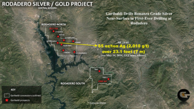
Garibaldi drills bonanza grade silver near-surface at Silver Eagle target – 2,010 g/t Ag (65 oz/ton) over 7 meters

Posted by AGORACOM-JC at 8:08 AM on Wednesday, May 14th, 2014

Photo_Asset_1
VANCOUVER, May 14, 2014 /CNW/ – Garibaldi Resources Corp. (TSX.V: GGI) (the “Company” or “Garibaldi”) is pleased to report that it has intersected exceptionally high silver grades within 30 meters of surface in first-ever drilling at the Company’s 45 sq. km Rodadero North Project in central Sonora State, Mexico. A second drill hole has started.

Highlights:

  • First hole at Silver Eagle target (SE-14-01) returned 2,010 g/t Ag (65 oz/ton) over 7 meters (23.1 feet) including 3 meters (9.9 feet) grading 4,565 g/t Ag (147 oz/ton);
  • A 50-meter step-out hole to the south of SE-14-01 has commenced;
  • Garibaldi’s exploration team has identified 7 high-priority targets in addition to Silver Eagle at Rodadero North – data compilation and regional work continues.

Steve Regoci, Garibaldi President and CEO, commented: “We’re excited with these initial drill results at Rodadero where we have made very effective use of hyperspectral remote sensing technology to outline a broad area of prospective targets. Given these numbers from Rodadero, and our recent solid drill results at La Patilla, we are moving at an accelerated pace in Mexico. In northwest British Columbia, we are extremely encouraged by the near-term discovery potential of our flagship Grizzly Project that covers more than half of the Sheslay Cu-Au porphyry district mineralized corridor. Garibaldi is uniquely positioned in two friendly jurisdictions to build shareholder value.”

Silver Eagle Target, Rodadero North

The first hole at Silver Eagle, drilled with Garibaldi’s company-owned rig, was designed to follow up on surface sampling along a silicified zone. DDH SE-14-01 intersected a strongly mineralized 7-meter zone.

Significant assay results, DDH SE-14-01:

Hole From (m) To (m) Width (m) Ag (g/t) Ag (oz/t) Au (g/t)
SE-14-1 19.5 26.5 7.0 2,010 65 0.42
includes 21.5 24.5 3.0 4,565 147 0.94
includes 21.5 22.5 1.0 7,633 245 1.5

At the present time, the geometry of the mineralized system is not known and true width for the drill intercepts remains to be determined. The widths given are downhole core lengths. The cut-off for the 7-meter intercept is 20 g/t Ag. The hole was drilled to a length of 100 meters.

The Silver Eagle target is an apparently flat lying silicified body that alters the upper parts of a conglomerate unit that overlies andesitic volcanic rocks. The silicified body is cut by several silver-bearing fractured zones that may reflect feeders to the silicified ‘cap’.

“We eagerly anticipate results from this next hole at Silver Eagle,” added Regoci. “In Mexico we’re also preparing for follow-up drilling at La Patilla and initial drilling at Iris. We have low exploration and drilling costs in Mexico, and these are also partly offset by continued royalty income from our pilot coal program at the Tonichi Project.”

Rodadero North & Rodadero South Target Areas

The Rodadero region hosts multiple precious metal occurrences over several tens of kilometers. Garibaldi has identified seven other targets at Rodadero North – Rambo, La Guata, Batuc, La Fortuna, La Colorada, Tarichi and Igualama – through mapping, sampling and the use of the Company’s proprietary hyperspectral database. To date, two targets have also been outlined at Rodadero South, where less exploration has been carried out, approximately five kilometers southeast of Rodadero North. A map showing the two project areas and targets is attached with this release and will be posted at www.GaribaldiResources.com in the Mexico “Projects” section under “Rodadero”. Alamos Gold’s Mulatos mine and Agnico Eagle’s La India mine are approximately 90 kilometers to the southeast.

Live Webinar and Corporate Video

Garibaldi will be conducting a live investor Webinar Wednesday, May 21, beginning at 1:15 p.m. Pacific (4:15 pm Eastern) through MarketSmart Communications Inc., official investor relations for Garibaldi. Log-in instructions for this presentation can be found on the Garibaldi homepage (www.GaribaldiResources.com).

Garibaldi is also pleased to announce the release of an updated short corporate presentation (video). You can view the video by going to the following web site URL:

http://www.garibaldiresources.com/s/Media.asp#video

Quality Assurance & Control

Garibaldi maintains strict QA-QC protocols for all aspects of its exploration programs that include the systematic insertion of blanks and standards into each sample batch. Acme Labs (now part of the Bureau Veritis group that includes BSI Inspectorate) performed assay analyses on core reported in this release, and ALS Global (formerly ALS Chemex) performed analyses on rock samples. All samples were assayed using certified and industry standard assay techniques for gold and multi-element packages and for over-limits. Au was analyzed by 30 or 50 gram fire assay with an atomic absorption finish, and other elements were analyzed by multi-element ICP. Samples in excess of 1,500 g/t Ag were analyzed by gravimetric methods.

Qualified Person

Dr. Craig Gibson, Certified Professional Geologist and a director of Garibaldi, is a non-arms length Qualified Person for the Company’s Mexico projects and the direct manager of the technical programs operated under contract by Prospeccion Y Desorrollo Minera del Norte (ProDeMin). Dr. Gibson has reviewed this news release and approved the content thereof.

About Garibaldi

Garibaldi Resources Corp. is an active Canadian-based junior exploration company focused on creating shareholder value through discoveries and strategic development of its assets in some of the most prolific mining regions in Mexico and British Columbia.

We seek safe harbor.

GARIBALDI RESOURCES CORP.

Per: “Steve Regoci”
Steve Regoci, President

Neither the TSX Venture Exchange nor its Regulation Services Provider accepts responsibility for the adequacy or the accuracy of this release.

SOURCE Garibaldi Resources Corp.

Image with caption: “Garibaldi drills bonanza grade silver near-surface at Silver Eagle target, Rodadero (CNW Group/Garibaldi Resources Corp.)”. Image available at: http://photos.newswire.ca/images/download/20140514_C8286_PHOTO_EN_40292.jpg

GARIBALDI RESOURCES CORP.
1150 – 409 Granville Street
Vancouver, BC V6C 1T2
Telephone: (604) 488-8851
Website: www.GaribaldiResources.com

Liberty Star Signs Final Settlement Agreement and Release of All Claims on Big Chunk Property, Alaska

Posted by AGORACOM-JC at 9:20 AM on Monday, May 12th, 2014

TUCSON, Ariz.–Liberty Star Uranium & Metals Corp. (“Liberty Star” or the “Company”)(OTCQB: LBSR) is pleased to announce a final settlement agreement and release of all claims has been signed by Liberty Star Uranium & Metals Corp. and Northern Dynasty Minerals Ltd. (“Northern Dynasty”) (NYSE: NAK), including its subsidiary/affiliate U-5 Resources Inc.

According to the signed agreement, all of the terms of the Loan and Mining Claims Sale Agreement dated June 29, 2010 (amended on July 15, 2010, September 8, 2011, November 2011, November 13, 2012 and November 20, 2012) have been satisfied; Northern Dynasty releases the Company from all claims. Accordingly, the final settlement agreement and release of all claims confirms that all obligations addressed in the November 13, 2012 loan settlement agreement, as amended on November 20, 2012, are extinguished.

“James A. Briscoe” James A. Briscoe, Professional Geologist, AZ CA
CEO/Chief Geologist
Liberty Star Uranium & Metals Corp.

Contacts

Agoracom Investor Relations
[email protected]
http://agoracom.com/ir/libertystar
or
Liberty Star Uranium & Metals Corp.
Tracy Myers, 520-425-1433
Investor Relations
[email protected]
Follow Liberty Star Uranium & Metals Corp. on Facebook , LinkedIn & Twitter LibertyStarLBSR

CLIENT FEATURE: (GGI: TSX-V) Recently Reported 10.4 g/t Au over 8.5 m near-surface

Posted by AGORACOM-JC at 12:40 PM on Monday, May 5th, 2014

WHY GARIBALDI RESOURCES CORP?

  • $3.2 million in working capital as per latest financials (Oct 31)
  • Attractive share structure
  • no warrants, no major financings since 2009
  • Drilling in progress – strong news flow from Mexico and B.C.

LEADERSHIP. MOVING FORWARD. BUILDING VALUE.

  • Synergistic mix of business, market & geological expertise
  • Drilling underway at La Patilla Gold Property (high-grade targets) plus multiple drill-ready targets at 3 district-scale projects in Mexico
  • Largest landholder (262km2) among juniors in Sheslay Cu – Au porphyry discovery area at top of B.C’s Golden Triangle

GARIBALDI APPROACH AND ADVANTAGE IN MEXICO


Through the strength of its geological team and the use of cutting- edge technology and proprietary data, Garibaldi has built a foundation for lasting success in Mexico:

  • GGI continues to accurately pinpoint the most prospective targets for potential new discoveries in large, district-scale land packages
  • Project value is being cost-effectively unlocked
  • Financial strength is being built (i.e., sale of Temoris option, current Tonichi pilot coal program generating royalty income)

La Patilla Project

  • First-ever diamond drilling at the La Patilla gold property in Sinaloa state has returned highly encouraging gold values near-surface, including an interval grading 10.4 grams per tonne gold over 8.5
  • Five of six holes drilled to test the La Patilla vein system intersected broad zones of mineralization along 75 metres of strike length to depths of approximately 50 metres

NORTHWEST B.C. – DOMINANT LANDHOLDER IN EMERGING SHESLAY CAMP


  • Successful exploration methods developed in Mexico are now being adopted to rapidly advance the company’s 100%-owned Grizzly Property
  • Multiple targets are being identified over 15 km from Grizzly West to Grizzly Central
  • GGI is the largest landholder among juniors in this highly prospective, under-exploited new Cu-Au porphyry discovery area in prolific Stikine Arch

12 Month Stock Chart

Garibaldi Signs Option to Buy Two B.C. Cu-Au Properties

Posted by AGORACOM-JC at 4:43 PM on Thursday, May 1st, 2014

GARIBALDI EXPANDS NORTHWEST B.C. PRESENCE

Recognizing the extraordinary mineral wealth potential and dynamic pace of development in northwest British Columbia, Garibaldi Resources Corp. has acquired two highly prospective copper-gold porphyry properties within the Stikine arch to complement its flagship Grizzly project in the prolific Sheslay Valley district.

“The rapid progress at Sheslay, combined with mining and infrastructure developments regionally, accelerated our plans to target and capture more exceptional ground within the Stikine Arch at the bottom of the market cycle,” stated Steve Regoci, President and CEO of Garibaldi. “This gives our shareholders a very strategic leveraged opportunity for the future while we focus immediately and vigorously on unlocking the value of the Grizzly.”

Garibaldi’s early bird strategy of selectively acquiring exciting key prospects exhibiting particular mineralogical features has consistently paid dividends for our shareholders,” Regoci continued. “This is evidenced by the acquisition and sale of the Temoris project in Mexico, plus the acquisition, expansion and accelerating exploration of our dominant land position, the largest of any junior, within the copper-gold porphyry rich Sheslay Valley corridor. The addition of Red Lion and Mount Saint Mary to the Garibaldi property portfolio emphasizes our confidence in a vibrant and exciting future for mining in this part of the province.”

Red Lion

The Red Lion prospect, comprising 35 sq. km, is located 60 km south of AuRico Gold’s Kemess mine and adjoins the Kiska Metals’ Kliyul Cu-Au porphyry project under option to Teck Resources Ltd. The Red Lion shows extremely strong Cu-Au stream sediment geochemistry in both Government Regional Geochemical Survey responses and follow-up proprietary surveys. Access and infrastructure at Red Lion are excellent with the powerline to the Kemess South mine only three km away.

Mount Sister Mary (MSM)

The MSM prospect, comprising 58 sq. km, is located approximately 50 km northeast of Imperial Metals’ Red Chris mine and is underlain by similar Triassic and Jurassic volcanic and plutonic rocks. Government Regional Geochemical Survey responses confirm prior assessment work in which at least eight Cu-Ag-Au showings have been documented on the property.

Option Terms

Both the Red Lion and the MSM properties were acquired from one vendor by way of a 4-year option agreement to purchase a 100% interest on the following terms: $18,500 CDN and 75,000 shares within 10 days of TSX Venture approval. Garibaldi will issue 150,000 common shares in each of the first three years of the option and 500,000 shares in the fourth year. The vendor retains a 2% NSR, half of which Garibaldi may purchase at any time for $2,000,000 CDN.

Shares Issued For Hat East and Hat East 2 Claims – Sheslay Valley

Garibaldi has issued the vendor 100,000 common shares of the Company pursuant to a property purchase agreement dated January 27, 2014, between the Company and an arms-length party for the Hat East and Hat East 2 claims comprising 1,653 hectares (see Garibaldi news release January 31, 2014). The shares are subject to applicable hold periods and may not be traded until July 10, 2014.

Corporate Fact Sheet

To view the updated Fact Sheet for Garibaldi Resources, please visit the following URL: http://www.garibaldiresources.com/i/pdf/GGI-FactSheet-April2014.pdf

Qualified Person

Carl von Einsiedel, P.Geo., a non-independent geological consultant and a Qualified Person as defined by NI-43-101, has reviewed this news release and approved the content thereof.

Garibaldi drills 8.5 m of 10.4 g/t Au at La Patilla

Posted by AGORACOM-JC at 6:13 PM on Thursday, April 24th, 2014

GARIBALDI INTERCEPTS 10.4 G/T AU OVER 8.5 METERS NEAR-SURFACE IN FIRST-EVER DIAMOND DRILLING AT LA PATILLA

Garibaldi Resources Corp. has provided a progress update on its exploration activities in Mexico. Of particular note, first-ever diamond drilling at the La Patilla gold property in Sinaloa state has returned highly encouraging gold values near-surface, including an interval grading 10.4 grams per tonne gold over 8.5 metres in LP-14. First-pass metallurgical testing is now under way in advance of a planned follow-up phase 2 drill program as Garibaldi systematically moves this project forward.

La Patilla highlights:

LP-14 intersected 10.4 grams per tonne gold over 8.5 metres within a wider 30-metre interval grading 3.1 grams per tonne gold;
Five of six holes drilled to test the La Patilla vein system intersected broad zones of mineralization along 75 metres of strike length to depths of approximately 50 metres;
Mineralization remains open in all directions, including at depth, and consists of gold-bearing quartz veins and breccia bodies in an epithermal, low-sulphidation system.

Regional highlights:

Garibaldi starts drilling test hole at Rodadero high-grade silver target in northern Sonora state;
First-ever drill program at Iris, adjacent to two operating mines in Chihuahua state, is scheduled to commence after completion of drilling at Rodadero.

Steve Regoci, president and chief executive officer of Garibaldi, commented: “This initial shallow drilling at La Patilla, where artisanal miners have been operating for decades, is an exceptional start for us. Our next step, which we have already commenced, is a preliminary test program for recovery using cyanide to determine the amenability of the mineralization to possible heap leaching. We look forward to the next round of drilling at La Patilla, which will test a potential source at depth for the near-surface mineralization we’ve confirmed in the vein system. Secondary structures/zones will be investigated further as well. Regionally, through the same cost-effective approach that gave us success with the Temoris option, we’re now at an exciting new stage of exploration not only at La Patilla, but with developments in Sonora at Tonichi and initial drilling at both Rodadero and Iris.”

  SHALLOW DRILLING HIGHLIGHTS 
            LA PATILLA VEIN SYSTEM 

Hole         From (m)   To (m)  Length (m) Au (g/t)

LP-14              11       41         30      3.1
includes         32.5       41        8.5     10.4
includes         38.5     39.5          1     82.3
LP-12            34.5     45.3       10.8      1.9
includes         39.2     41.5        2.3      6.8
LP-10               0     31.6       31.6      0.8
LP-03             3.1       42       38.9      0.8
includes         15.7       42       26.3      1.1
LP-02             3.6     17.3       13.7      0.9

Reported widths are believed to closely
approximate true width.
All intervals were calculated using a
0.2-gram-per-tonne-gold cutoff.
Up to 8.5 metres of contiguous samples below
cut-off have been included in the larger
intercepts in LP-14 and LP-03.

The presence of mineralization in the wallrocks of the La Patilla vein system could be favorable for a bulk mining open-pit scenario with a relatively low strip ratio. Results from two shallow exploratory holes adjacent to the La Patilla vein system suggest these areas warrant follow-up work. Hole LP-13 (the Jose vein) returned 5.8 grams per tonne gold over 2.5 metres and 2.1 grams per tonne gold over 1.5 metres from different near-surface depths. Meanwhile, hole LP-04 (collared 75 metres east of LP-14) cut two zones in a stockwork system: 0.4 gram per tonne gold over 10.5 metres and 0.5 gram per tonne gold over 10.7 metres.

Results from the second main target, the Murcielago breccia located to the northeast of the La Patilla vein system, were partly inconclusive due to poor recoveries and the fact that the most important holes to test under the high-grade mineralization in the underground workings were not completed to the target depths because of difficult drilling conditions (the most significant intersection from seven holes was 18.6 metres grading 0.6 gram per tonne gold in LP-01). The prospective Murcielago area will be followed up through reverse circulation drilling.

An updated map for the La Patilla gold property, including locations for all 15 holes totalling 1,245 metres, can be found on the company’s website.

Rodadero and Iris projects

Garibaldi is using its company-owned drill rig for a test hole, currently in progress, at the Rodadero property in Sonora state. Aided by its hyperspectral remote sensing technology, Garibaldi is now focusing on a 6,500-hectare area at Rodadero with high-grade silver targets and the potential for an epithermal gold system. This property has never previously been drilled.

Meanwhile, Garibaldi is preparing to drill a series of first-ever holes at the Iris project strategically located in the heart of a robust mining and exploration camp in Chihuahua state. Agnico Eagle Mines Ltd. and Carlos Slim’s Minera Frisco have operating mines immediately adjacent to Iris.

Tonichi project — Locust target

Garibaldi continues to advance its Locust copper-gold porphyry target that forms part of its Tonichi project in Sonora state. Based on local zonation patterns in the context of classic porphyry models grading outward from a core, attention is now focused on an area just over half a kilometre north of the three most recently completed holes, MAR-13-03, MAR-13-02 and MAR-13-01. To date, Garibaldi has completed 3,000 metres of diamond drilling in 17 widely spaced holes at Locust. A series of breccia bodies have been outlined along an east-west-trending shear zone coincident with a broad envelope of gold and copper mineralization mapped over a five-kilometre trend and one to two kilometres across. MAR-13-03 was designed to test the geological continuity of the hypogene zone intersected in MAR-13-02. MAR-13-03 reached 254 metres, intercepting strong potassic, sericitic and propylitic alteration with narrow zones of anomalous copper and gold mineralization. The wide intercepts of anomalous to low-grade copper-gold mineralization and porphyry-style alteration/mineralization in holes MAR-13-03 and MAR-13-02 are located 800 metres west of MAR-13-01 and over two kilometres west of the original Locust target, providing a significant step-out to the area tested.

Quality assurance and control

Garibaldi maintains strict quality assurance/quality control protocols for all aspects of its exploration programs that include the systematic insertion of blanks and standards into each sample batch. ALS Chemex and Acme Labs (now part of the Bureau Veritis group, which includes BSI Inspectorate) performed assay analyses reported in this release. All samples were assayed using the respective laboratories’ certified and industry standard assay techniques for gold and multielement packages and for overlimits. Gold was analyzed by 30-gram or 50-gram fire assay with an atomic absorption finish, and other elements were analyzed by multielement ICP.

Qualified person

Dr. Craig Gibson, certified professional geologist and a director of Garibaldi, is a non-arm’s-length qualified person for the company’s Mexico projects and the direct manager of the technical programs operated under contract by Prospeccion Y Desarrollo Minero del Norte (ProDeMin). Dr. Gibson has reviewed and approved the contents of this news release.

Liberty Star Receives Expanded ZTEM Report Over Tombstone Super Project

Posted by AGORACOM-JC at 9:31 AM on Wednesday, April 2nd, 2014

TUCSON, Ariz. — Liberty Star Uranium & Metals Corp. (“Liberty Star” or the “Company”) (OTCQB: LBSR) is pleased to announce geophysics contractor Geotech Ltd. has delivered a ZTEM report covering the Tombstone Super Project (TSP) for porphyry copper, gold, molybdenum, rare earth elements and other metals in southeast Arizona. The report covers approximately 130 square miles including the Company’s Hay Mountain Project.

The ZTEM report will allow further appraisal of seven mineral targets located outside of the Hay Mountain geochemical survey area (2012) identified by CEO/Chief Jim Briscoe and other geological analysts. Further analysis by Geotech’s experts and Briscoe working in concert could yield additional information and refinement on the seven targets and identify additional targets beneath cover.

Briscoe states: “The expanded ZTEM report will allow Liberty Star to correlate surface features with exploration to great depth in the Tombstone caldera and identify the location of additional targets. Along with the Hay Mountain analysis, the new ZTEM report indicates that the Tombstone caldera holds the potential for hosting commercial grade mineralization in line with the known and assumed mineral wealth of the region which encompasses southeast Arizona and northern Mexico. We continue seeking well-funded, knowledgeable partners to help us with a drilling program to begin measuring the potential of Hay Mountain, as drilling is the next step there. There is good potential for further partnerships in the Tombstone Super Project at large.”

“James A. Briscoe” James A. Briscoe, Professional Geologist, AZ CA
CEO/Chief Geologist
Liberty Star Uranium & Metals Corp.

Forward Looking Statements

Statements in this news release that are not historical are forward-looking statements. Forward-looking statements in this news release include our exploration plans, that we have seven mineral targets, that we have the potential for commercial grade mineralization on our property, and that the next step is drilling. Factors which may delay or prevent these forward-looking statements from being realized include: we may not be able to raise sufficient funds to complete our intended exploration, keep our properties or carry on operations; misinterpretation of data is possible; and we may be unable to continue exploration due to permitting requirements, weather, logistical problems, labor or equipment problems or hazards even if funds are available. Despite encouraging data there may be no commercially exploitable mineralization on our properties. Readers should refer to the risk disclosures in the Company’s recent 10-K and the Company’s other periodic reports filed from time to time with the Securities and Exchange Commission.

Follow Liberty Star Uranium & Metals Corp. on Facebook , LinkedIn & Twitter @LibertyStarLBSR

Contacts

Agoracom Investor Relations
[email protected]
http://agoracom.com/ir/libertystar
or
Liberty Star Uranium & Metals Corp.
Tracy Myers, 520-425-1433
Investor Relations
[email protected]

AGORACOM CLIENT FEATURE – (GGI: TSX-V) $3.2M in Working Capital, Attractive Share Structure, Drilling In Progress

Posted by AGORACOM-JC at 10:59 AM on Thursday, March 6th, 2014

  • $3.2 million in working capital as per latest financials (Oct 31)
  • Attractive share structure
  • no warrants, no major financings since 2009
  • Drilling in progress – strong news flow from Mexico and B.C.

LEADERSHIP. MOVING FORWARD. BUILDING VALUE.

  • Synergistic mix of business, market & geological expertise
  • Drilling underway at La Patilla Gold Property (high-grade targets) plus multiple drill-ready targets at 3 district-scale projects in Mexico
  • Largest landholder (262km2) among juniors in Sheslay Cu – Au porphyry discovery area at top of B.C’s Golden Triangle

GARIBALDI APPROACH AND ADVANTAGE IN MEXICO

Through the strength of its geological team and the use of cutting- edge technology and proprietary data, Garibaldi has built a foundation for lasting success in Mexico:

  • GGI continues to accurately pinpoint the most prospective targets for potential new discoveries in large, district-scale land packages
  • Project value is being cost-effectively unlocked
  • Financial strength is being built (i.e., sale of Temoris option, current Tonichi pilot coal program generating royalty income)

NORTHWEST B.C. – DOMINANT LANDHOLDER IN EMERGING SHESLAY CAMP


  • Successful exploration methods developed in Mexico are now being adopted to rapidly advance the company’s 100%-owned Grizzly Property
  • Multiple targets are being identified over 15 km from Grizzly West to Grizzly Central
  • GGI is the largest landholder among juniors in this highly prospective, under-exploited new Cu-Au porphyry discovery area in prolific Stikine Arch

12 Month Stock Chart


Liberty Star Provides Summary of Hay Mountain ZTEM Report

Posted by AGORACOM-JC at 9:41 AM on Tuesday, March 4th, 2014

Liberty Star Provides Summary of Hay Mountain ZTEM Report

TUCSON, Ariz. —Liberty Star Uranium & Metals Corp. (“Liberty Star” or the “Company”)(OTCQB: LBSR) is pleased to present a summary of the final report submitted by Geotech: Interpretation Report on a Helicopter-Borne Z-Axis Tipper Electromagnetic (ZTEM) and Aeromagnetic Geophysical Survey: The Hay Mountain Project Tombstone Mining District, Cochise County, Arizona For: Liberty Star Uranium & Metals Corp.

“During the early part of February, Geotech completed a 3D inversion using a coarse mesh study. When this was interpreted, it was clear that a fine mesh 3D magnetic inversion would be particularly useful and result in better resolution of what was going on at depth.”

This final report includes updated interpretation based on 3D magnetics. Geotech will use data from this report in a presentation on March 4 at PDAC 2014 (NR 173). Two images from that presentation can be viewed March 4 on the Liberty Star web site as well. The information in this report has generated more specific targets for the Company’s upcoming drilling program at Hay Mountain, which will commence when adequate funding is obtained.

CEO/Chief Geologist Jim Briscoe’s summary of the report:

“During the early part of February, Geotech completed a 3D inversion using a coarse mesh study. When this was interpreted, it was clear that a fine mesh 3D magnetic inversion would be particularly useful and result in better resolution of what was going on at depth.

One of the images displayed on our web site is a cross section showing the results of this fine mesh 3D magnetic interpretation, along with the ZTEM interpretation as well. The coarse mesh inversion was 250 meters (m) x 250m x 125m mesh, whereas the fine mesh inversion was 50m x 50m x 20m mesh. Obviously much smaller items can readily be resolved at this resolution.

When the fine mesh 3D magnetic interpretation is plotted it can be seen that there is a sub horizontal top to the anomalies, which may well be skarn containing pyrite which has oxidized to oxidized skarn, perhaps destroying most of the magnetism in the upper zone. This would be equivalent to a classic oxidation zone, perhaps containing a chalcocite (Cu2S) blanket. This has certain similarities to the data reported on the similar appearing gold skarn deposits in Guerrero State, Mexico (also within the Geotech PDAC 2014 presentation).

These more highly resolved magnetic data suggest that the groundcover is 100 feet to 300-500 feet below the current surface, which corresponds well to the known geology. It also suggests that we may have an enriched zone of both gold and copper, perhaps within open pit mineable depths over a wide area. Additionally, the skarn mineralization appears to go to a great depth of at least approximately 1,500 meters. The only thing left is to drill these anomalies to determine their exact nature. While we do not have a deal as yet, there is an increasing interest by several funding entities and large companies.”

“James A. Briscoe” James A. Briscoe, Professional Geologist, AZ CA
CEO/Chief Geologist
Liberty Star Uranium & Metals Corp.

Forward-Looking Statements

Statements in this news release that are not historical are forward-looking statements. Forward-looking statements in this news release include our exploration plans, that we have an enriched zone of both gold and copper perhaps within open pit mineable depths over a wide area, that the only thing to do is drilling, and that we have some parties interested in financing us. Factors which may delay or prevent these forward-looking statements from being realized include: we may not be able to raise sufficient funds to complete our intended exploration, keep our properties or carry on operations; misinterpretation of data is possible; and we may be unable to continue exploration due to permitting requirements, weather, logistical problems, labor or equipment problems or hazards even if funds are available. Despite encouraging data there may be no commercially exploitable mineralization on our properties. Readers should refer to the risk disclosures in the Company’s most recent 10-K and the Company’s other periodic reports filed from time to time with the Securities and Exchange Commission.

Contacts

Agoracom Investor Relations
[email protected]
http://agoracom.com/ir/libertystar
or
Liberty Star Uranium & Metals Corp.
Tracy Myers, 520-425-1433
Investor Relations
[email protected]

CLIENT FEATURE: (LBSR: OTCQB) Liberty Star Uranium & Metals, Small Caps Are BACK!

Posted by AGORACOM-JC at 11:59 AM on Wednesday, February 19th, 2014

Liberty Star Uranium & Metals Corp. (LBSR: OTCQB) is an Arizona-based mineral exploration company engaged in the acquisition and exploration of mineral properties in the states of Arizona and Alaska. Currently the company controls properties totaling approximately 26,011 acres (about 41 square miles) which are located over what management considers some of North America’s richest mineralized regions for copper, gold, silver, molybdenum (moly), and uranium.

Arizona

The Tombstone Super Project (TSP) hosts Liberty Star’s premiere multi target property: Hay Mountain. The TSP initially consisted of 33 unpatented federal lode mining claims over a projected covered porphyry copper mineral center in Cochise County, Arizona. In 2011 and 2012 more USBLM claims and Arizona Mining Exploration Permits were added after Chief Geologist James Briscoe discovered a large multimodal anomaly over a large covered porphyry copper mineral center within the larger TSP area. Currently, the TSP entails 14.67 square miles of claimed lands with Hay Mountain covering 13.45 square miles of the claim area. The entire claim area has undergone formal review by SRK Consulting. SRK produced three separate NI 43-101 compliant technical reports (technical reports per USSEC) which recommended further exploration for copper, gold, moly and other metals.

The company received the final draft ZTEM report from Geotech Ltd. ZTEM electromagnetic measurement data has been carefully analyzed by Geotech’s Chief Geophysicist Jean Legault, P. Geo, P. Eng. Among the report’s findings:

1. There are as many as 10 meaningful targets within the Hay Mountain Project area.

2. Hay Mountain contains a major anomaly centered on the geochem anomaly reported by Liberty Star (NR 127).

From the “Executive Summary” Summary Interpretation Report on a Helicopter-Borne
Z-Axis Tipper Electromagnetic (ZTEM) and Aeromagnetic Geophysical Survey:
The Hay Mountain Project Tombstone Mining District, Cochise County, Arizona
For: Liberty Star Uranium & Metals Corp.:

“The Hay Mountain Property is mainly underlain by a thick sequence of Paleozoic quartzite, limestone and siltstones, but potentially hosts buried porphyry copper deposits at structural intersections and under basin-fill formations. There is additional potential for polymetallic carbonate-hosted replacement deposits (CRD), as well as shallow chalcocite blanket porphyry type deposits and also skarn type porphyry copper deposits. Previous soil and vegetation geochemical surveys have identified a coincident Au-Pb-Cu anomaly and larger Mo-halo in the center of the property. The objective of the ZTEM surveys is to identify favourable magnetic and resistivity signatures related to potentially more deeply buried porphyry copper, CRD/skarn and chalcocite replacement deposits at Hay Mountain. The Magnetic surveys have determined that Hay Mountain hosts a large dominant magnetic high that lies buried below the Paleozoic sediments is centered over the Liberty Star geochemical anomaly and remains open to the south…As many as ten (10) magnetic anomalies have been defined.”

Company CEO/Chief Geologist Jim Briscoe’s summary: “Geotech’s Chief Geophysicist Jean Legault and I met for more than 12 hours in three sessions of four hours each over the last 10 days through GoToMeeting, me in Tucson and Legault in Canada, so we could look at the same images at the same time to interpret the ZTEM data. With my geological expertise in the Tombstone area and his geophysical expertise on copper anomalies all over the world, we came to the same conclusion that there is substantial evidence that the Hay Mountain area needs to be drilled. While I had five targets in mind, the ZTEM report indicated 10. I am pleased that the evidence continues to be mutually reinforcing that we may be looking at a major porphyry copper structure. The next step is drilling. We have a detailed cost analysis and will plot drill sites according to what we are seeing with the ZTEM. Once funding is secured, we will drill ASAP.”


The Company maintains claims on two other claim blocks in Arizona: The East Silver Bell Porphyry Copper Project is within the Silver Bell Mining District located northwest of Tucson, Arizona. Liberty Star’s North Pipes Super Project comprises 417 standard Federal lode mining claims covering over 38,000 acres in numerous blocks targeting breccia pipe hosted uranium deposits. The breccia pipes are part of the large uranium bearing breccia pipe terrain which occurs on the Arizona Strip lying just south of the Utah border.


East Silver Bell Porphyry Copper Project is within the Silver Bell Mining District located northwest of Tucson, Arizona. Asarco Mining LLC with joint venture partner Mitsui Mining of Japan currently operates open pit copper mines in the area. Asarco has a solvent extraction (SXEW) plant approximately 4 1/2 miles to the west of the East Silver Bell Project property line. Liberty Star’s property, within the same mining district, includes 26 unpatented lode mining claims covering a previously unrecognized porphyry copper center. Two mining companies had some interest in the area during the late 1990s but relinquished the ground despite revealing enriched copper in one hole and substantial amounts of leached capping in all other holes, an indicator for porphyry copper deposits. Stagnant copper prices contributed to the abandonment of the ground prior to the identification of any ore body. The claims currently are within the Ironwood National Monument, which was established after the claims were staked.

Alaska

Through our wholly owned subsidiary, Big Chunk Corp., Liberty Star holds claims to the Big Chunk Super Project (BCSP), covering approximately 101 square miles in southwestern Alaska, targeting copper, gold and molybdenum. The Big Chunk lands are within nine miles the Pebble property, which promises to be among the richest mining districts in the world for copper, gold and moly for decades to come.

Hub On AGORACOM / Corporate Website


AGORACOM Welcomes (SX: CSE) St. Georges Platinum and Base Metals

Posted by AGORACOM-JC at 10:00 AM on Thursday, February 13th, 2014

SX: CSE

St-Georges Platinum & Base Metals Ltd. is a junior Platinum, Palladium, Rhodium, Copper, Cobalt and Nickel explorer with projects in the Province of Quebec, Canada. Headquartered in Montreal, the Company’s stock is listed on the CSE under the symbol SX, the OTCQX under the symbol SXOOF and the Berlin Stock Exchange under the symbol 85G.

The company owns the Villebon Copper-Nickel and PGEs property in Abitibi and a 100% interest in the Julie and Isoukustouc Nickel-Copper-PGEs projects.

It also owns a 100% interest in ten North Shore properties that constitute the Manicouagan constellation which are explored for Nickel, Copper, Platinum, Palladium and Graphite and 50% equity interest in 6 properties explored for graphite with Amseco Exploration, all the latter being on Quebec’s North Shore near the deep-seaport town of Baie-Comeau.

Isoukoustouc Complex:

St-Georges Platinum expanded the Isoukoustouc and Julie properties by staking an additional 238 claims to its 57 mining claims. In addition, 13,185 hectares have been added to approximately 34 sq. Km in the Isoukoustouc Nickel Trend.

Manic-3, Mathilda & B-40

(Copper, Nickel, Palladium, Cobalt)

Lac Julie: 124 km northwest of the town of Baie-Comeau, Quebec

(Average assay values of 0.33 wt. % Cu and 1.78 wt. % N)

Manicouagan Constellation:

A prospective grass root target for PGE’s with limited historical work. Additional claims might be added or withdrawn from this group of properties in the coming year as the Company plans to improve this holding.

Villebon:

St Georges owns a 70% interest in the core portion of the Villebon property situated less than 2 km east of the Provincial Highway #117, and 45 km south-east of Val d’Or .
The company entered into a binding agreement to acquire 100% of two mineral mining projects in the Kasempa and Mwinilunga Districts in Western Zambia.

Shongwa Project (Kasempa District)

The Shongwa IOCG & Nickel project is located in Northwestern Zambia. The project area lies approximately 60km northwest of the town of Kasempa in northwest Zambia. The area is poorly developed with only minor trails away from the gravel Kasempa-Kaoma road link. The area consists of forested and relatively flat covered plains with some rolling hills and some permanent watercourses. Minor areas of habitation and subsistence farming exist to the south of Shongwa.

The Large Scale Prospecting License (LPL) 14817-HQ-LPL covers an area of 726 square km. It was recently converted into 3 mining licenses covering the same total territory.

The Shongwa project is the site of one of the oldest known deposits in Zambia dating back to the fourth century. Since the rediscovery of these ancient workings in 1899, the area has been mined intermittently for the recovery of high-grade copper ore. From 1903 until 1914, copper was recovered by underground mining of high-grade veins, followed by hand sorting and direct smelting. Mining activities terminated with the onset of World War 1.

Hub On AGORACOM / Corporate Website