Agoracom Blog Home

Posts Tagged ‘copper’

St-Georges to Acquire All Outstanding Shares of Iceland Resources EHF $SX.ca

Posted by AGORACOM-JC at 1:33 PM on Tuesday, November 22nd, 2016

Sx hub logo

  • Entered into a binding agreement with Iceland Resources ehf to acquire all its outstanding shares
  • Iceland Resources owns multiple polymetallic exploration & development projects in Iceland and has direct or indirect access to all active mineral tenure, claims and mineral leases in Iceland

Montreal, Quebec / November 22, 2016 – St-Georges Platinum and Base Metals Ltd. (CSE: SX)(OTC: SXOOF) (FSE: 85G1) is pleased to announce that it has entered into a binding agreement with Iceland Resources ehf to acquire all its outstanding shares. Iceland Resources owns multiple polymetallic exploration & development projects in Iceland and has direct or indirect access to all active mineral tenure, claims and mineral leases in Iceland.

The Opportunity

Iceland Resources ehf is a privately-owned Icelandic corporation with gold/silver/copper/cobalt/zinc projects in Iceland.

Iceland is an important producer and developer of geothermal energy. St-Georges management has been active over the last few years in Iceland with the goal of securing access to geothermal operations to test the development of technologies allowing the extraction of lithium and light minerals from the brines being pumped from the geothermal wells and for the extraction of a large variety of precious and base metals found in the mud rejected from the same operations.

Enrico Di Cesare, Director of St-Georges commented: “(…) With St-Georges focused on innovative extraction technologies and working on strategic alliances with several providers, this opportunity is exciting; it is an excellent platform to apply new technologies, monetize tailings and demonstrate our solutions which also address environmental issues. The focus is to economically recover precious and base metals and to provide an avenue for positive environmental remediation of the by-products. St-Georges is also looking at niche and value added products that this opportunity lends itself to.”

Terms of Acquisition

St-Georges will create a subsidiary that will become the owner of Iceland Resources. 40% of this subsidiary will be owned by the Iceland Resources shareholders and the remaining 60% will be owned by St-Georges. Additionally, St-Georges makes the following commitments:

-Issuing 6,000,000 common shares of St-Georges to Iceland shareholders with a 12-month escrow release schedule;

-Issuing a $350,000 debenture, bearing a 6% annual interest (cash or shares), maturing in November 2026 to be distributed to Iceland shareholders and some creditors; and

-$1,000,000 of expenditure on the Iceland assets over the next 24 months, including mineral exploration expenses and metallurgical process research & development.

Iceland Resources Projects

Iceland Resources currently has 9 defined mineral exploration and development projects in Iceland (8 licenses or license applications held directly and one within a Joint-Venture). Other opportunities are being sought after with the collaboration of St-Georges (with the possibility to deploy St-Georges technologies result from its R&D initiatives).

St-Georges intends to direct most of its efforts in the next 24 months to 3 priority projects:

Reykjanes Project (EL 01) (Au-Ag-Cu-Zn)

The 897.5 km2Reykjanes licence area is in close proximity to the capital Reykjavik and the international airport in the town of Keflavik and is supported by good transport infrastructure with main highways running through it. The project is prospective for gold, silver, copper, zinc and cobalt. The Company also plans to apply for licenses to evaluate the lithium potential of the geothermal brines present on the property.

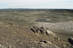
Figure 1. The Reykjanes Project

The Thormodsdalur Project (EL-14) (Au-Ag-Cu)

Thormodsdalur is located about 20km east of the city centre of Reykjavik and south-east of the lake Hafravatn. The project was discovered in 1908. The property produced mineral concentrate from 1911 to 1925 when over 300 meters of tunnels where dug alongside surface excavations. The ore recovered was transported to Germany and historic sources reported values ranging between 11g/t and 315g/t Au. Note: All information pertaining to mineral resources, grades or operational results herewith presented are historical in nature and while relevant, the information was obtained from sources that cannot be independently verified and that are not compliant with National Instrument 43-101 reporting standards.

More recently, visible gold was seen in cores from geothermal wells located on the project. This new discovery compelled the Icelandic government to create a mining entity for gold exploration in Iceland called Malmis.

Studies between 2005 and 2013 identified the project mineralization as a low sulphidation system containing banded chalcedony and ginguro. Petrographic analysis of the vein material identified gold occurring in its free form and as part of an assemblage with pyrite and chalcopyrite. Petrographic and XRD studies show an evolution of the vein system from the zeolite assemblage to quartz adularia and lastly to minor calcite. In the area, 32 holes have been drilled for a total of 2439 meters.Gold values vary from less than 0.5 ppm to the maximum of 415 ppm. (These values were obtained from selected random intervals and cannot be construed to be representative of the any particular thickness or overall length).

Iceland Resources entered in to a Joint Venture agreement with Melmi ehf, Malmis hf (majority government owned) and Gold Island Limited. Melmi is the owner of the Thormodsdalur license that was first granted in October 2004. Melmi is owned by Malmis (51%) and Gold Island (49%).

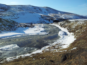
Figure 2. The Thormodsdalur Project

The Vopnafjordur Project (EL-05) (Au-Ag-Te) (Bi-Co-Sb-Se-Zn)

The Vopnafjordur licence covers 598.5 km2(Maps, fig. 3 & 4) and is valid until July 2021. Exploration in Vopnafjordur was carried out by Malmis between 1991 and 1993 in the form of BLEG surveys and vein sampling. Follow-up work was carried out by Melmi in 1997, which carried out stream sediment and helicopter-assisted rock chip sampling in the Vopnafjordur area. The rock chip sampling programme focused on areas of strong alteration, known quartz-carbonate-pyrite veining and in selected structural settings. The sampling programme indicated anomalous antimony, selenium and tellurium values in the northern rhyolitic centre and further identified anomalous gold, antimony, bismuth and zinc in an acid intrusion in the central southern part of the licence.

Recently, a comprehensive review of the BLEG and rock chip sampling programme was undertaken alongside satellite interpretation of the whole of the Vopnafjordur licence and a short exploration program in August 2016. In addition to the two volcanic centres identified in the 1990s, a number of regional fault zones associated with elevated levels of key pathfinder elements and occasionally gold was identified. The geological team is expecting assay results shortly.

These areas will be investigated further by the Company’s geological team in 2017, which will carry out close-spaced traverse mapping and grab sampling of key fault structures identified by previous exploration.


Click Image To View Full Size

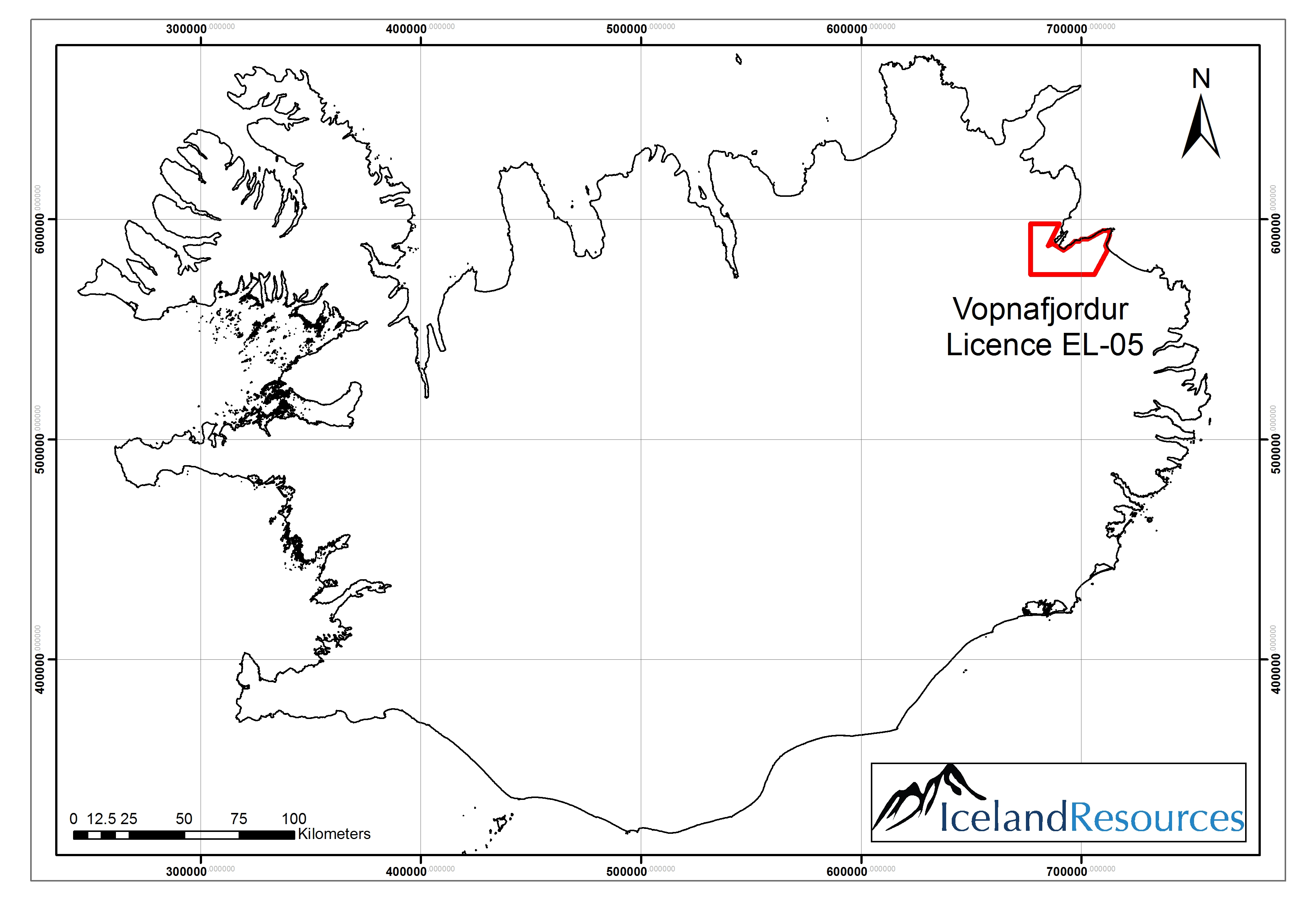
Figure 3. Vopnafjordur licence EL-05 is situated in the Nord Austurland region of NE Iceland


Click Image To View Full Size

Figure 4. Extent of Vopnafjordur licence boundaries. Map scale 1:200,000


Click Image To View Full Size

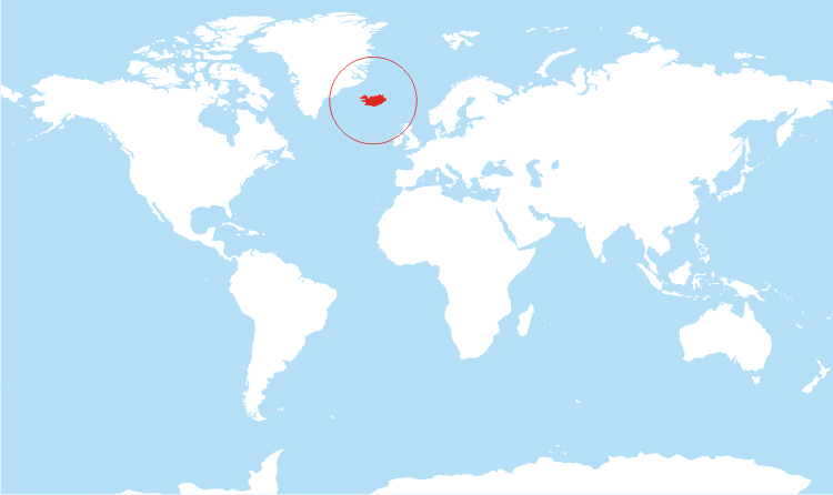
Figure 5. World map showing Iceland


Click Image To View Full Size

Figure 6. Map of Iceland with location of the projects

Icelandic Geology is unique and considered relatively young in geology term. Iceland lies in the divergent boundaries of the Mid Atlantic Ridge. The buoyancy of the Iceland plume leads to dynamic uplift of the Iceland plateau, and high volcanic productivity over the plume has developed an anomalous volume of volcanic material and magma chambers at depth.

Iceland has not been thoroughly mapped and geological exploration has been limited when compared to other jurisdictions. St-Georges now have the unencumbered opportunity to explore Iceland’s potential starting with its most known prospective target sites with data generated from existing geological work and geothermal operations around the country. Furthermore, St-Georges technologies should enable the team of Iceland Resources to unlock the potential for prospective lithium brines and mud tailings that were not considered in the past.

Vilhjalmur Thor Vilhjalmsson, director of Iceland Resources, commented: “The opportunity to combine the resources of both companies, our extensive knowledge of Iceland and its geology and the addition of St-Georges team’s expertise in metallurgical processing and eco-mining environmental friendly solutions, provides a unique offering to the market and stakeholders of both companies (…) St-Georges brings a portfolio of R&D initiatives aimed at reducing the environmental impact of mining activities and improving producers’ financial bottom line. Iceland like the Scandinavian countries is a place of certainty in regulations and mining law with reliable and accessible data available from government bodies thus opening possibilities to get additional licenses with historical data available similar to work previously done in Iceland as well as in Greenland (…) we believe that we found a good home for our shareholders in St-Georges and we are excited at the prospect of the proposed 2017 exploration and development campaigns.”

General Disclaimer: The current press release contains references to mineral sampling results that are provided by Iceland Resources or were sourced in the geological literature published by the Icelandic government or its departments. St-Georges has not sampled and analysed these samples. Readers should exercise caution as real width, depth or length of the mineralisation encounter is not defined. No resource estimate that is compliant with the standard of the National Instrument 43-101 is currently available.

The technical information in this release has been reviewed and approved by Mr. Herb Duerr, P. Geo. a ‘qualified person’ as defined by National Instrument 43-101Standards of Disclosure for Mineral Projects.

ON BEHALF OF THE BOARD OF DIRECTORS

“Frank Dumas’

FRANK DUMAS, PRESIDENT & CEO

About St-Georges

St-Georges is developing new technologies to solve the biggest environmental problems in the mining industry. If thesenew technologiesare successful, they should improve the financial bottom line of current mining producers. The potential success of these technologies would also involve upgrading certain current known metal resources to economic status while addressing the environmental and social acceptability issues. The Company also explores for Nickel on the Julie Nickel Project & for industrial minerals on the Quebec’s North Shore and for Lithium and rare metals in Northern Quebec and in the Abitibi area.Headquartered in Montreal, St-Georges’ stock is listed on the CSE under the symbol SX, on the US OTC under the Symbol SXOOF and on the Frankfurt Stock Exchange under the symbol 85G1. For additional information, please visit our website at www.stgeorgesplatinum.com

About Iceland Resources EHF

Iceland Resources ehf is a junior mineral exploration company with a focus on the Scandinavian region. The company has one licence in the Vopnafjordur area in Iceland and further seven areas pending issue totalling over 4,000km2. The company also has an earn-in agreement with Melmi ehf and Gold Island Ltd to earn into the well-known Thormodsdalur licence where gold grades up to 415 g/t have been identified and the partners are working towards a NI 43-101 compliant resource.http://www.icelandresources.is

The Canadian Securities Exchange (CSE) has not reviewed and does not accept responsibility for the adequacy or the accuracy of the contents of this release.

Finore Mining to Acquire 100% interest in Panther Creek Cobalt Property, Idaho, Changes Name to Hybrid Minerals Corp. $FIN.ca

Posted by AGORACOM-JC at 10:44 PM on Thursday, October 6th, 2016

Fm_copy

  • Signed a Definitive Agreement with Utah Mineral Resources LLC to acquire 100% interest on the Panther Creek Cobalt property, East-Central Idaho
  • Located in the heart of the Idaho cobalt belt, home to the Salmon Canyon and Iron Creek Deposits
  • Road accessible
  • Consists of 50 lode mining claims with a total area of 1000 acres located in Lemhi County

Vancouver, B.C. / October 6, 2016 – FINORE MINING INC. (CSE: FIN; OTCQX: FNREF) (the “Company” or “Finore”) -announces that the Company signed a Definitive Agreement with Utah Mineral Resources LLC (“UMR”) to acquire 100% interest on the Panther Creek Cobalt (“Co”) property, East-Central Idaho.

The Panther Creek Cobalt Property (“the Property”) is located in the heart of the Idaho cobalt belt which is home to the Salmon Canyon and Iron Creek Deposits. The property is road accessible and located 26 miles west of the Salmon, East-Central Idaho. The property consists of 50 lode mining claims with a total area of 1000 acres located in Lemhi County.

The Property is well located within the vicinity of the Blackbird copper-cobalt Mine in the famous Blackbird District. The copper-cobalt mineralization is hosted in the micaceous quartzites of the Apple Creek Formation of the well-known Idaho Cobalt Belt. A historic mine adit on the property was channel sampled by US Geological Survey and returned 1.04% cobalt and 4.14% copper across 10 feet or 3.04 metres (Re: US Geol. Surv. Open File Report 98-478). Extensive exploration consisting of detailed geological mapping emphasizing stratigraphy and structure, systematic geochemical soil sampling and trenching is required to confirm the historical result as this does not conform to the NI 43-101 rules and regulations.

Idaho cobalt belt

The Idaho cobalt belt trends northwest-southeast for nearly 60 km in east-central Idaho (Fig. 1). Included within this belt are numerous historic mines and prospects of the centrally located Blackbird district, the Salmon Canyon deposit at the northwest end, and deposits of the Iron Creek area at the southeast end (U.S. Geological Survey, 2010). The Idaho cobalt belt is important nationally because it contains the largest known cobalt resources in the United States (Slack et al., 2012). Ecobalt Solutions Inc. is developing the Idaho Cobalt Project, located in the Blackbird district. Ecobalt completed a Preliminary Economic Assessment with a measured and indicated resource of 3.48 million tonnes grading 0.55% Co and 0.85% Cu.

History and production

Production in the Blackbird district began in 1917 following initial discovery of the sulfide deposits in 1893. Minor Co was produced from 1917 to 1920 at the Haynes-Stellite Mine (Bennett, 1977). Major production began in 1949 and continued intermittently to 1960 at the Blackbird (Uncle Sam) underground mine and the Blacktail open pit, which together yielded ca. 5 Mt of ore averaging 1.5 wt % Cu and 0.6 wt % Co.

The location of the Idaho Cobalt Belt with the historic mines and occurrences is shown in the figures below. The Panther Creek prospect is located in the Blackbird district.


Click Image To View Full Size

Map of central Idaho showing location of mineral deposits (modified, Lund, et al, 2011. Econ Geol. v.106) Dot overlay shows location of Idaho cobalt belt. Index map is (upper right) shows location of Late Cretaceous Idaho batholith relative to area of this figure. Numbers refer to important named mines and prospects: 1 = Yellowjacket mine, 2 = Salmon Canyon copper mine, 3 = more than 40 deposits of the Blackbird district including the Panther Creek property, 4 = Musgrove prospect, 5 = Blackpine mine, 6 = Iron Creek prospect, 7 = Spring Creek deposits, 8 = Shoup area mines, 9 = Pine Creek mines, 10 = Diamond Creek mines, 11 = Copper King mine, 12 = Pope Shenon mine, 13 = Woods Creek deposit, 14 = McConn Creek deposit, 15 = Ulysses mine, 16 = Lemhi Pass thorite mines and prospects, 17 = Copper Queen Mine


Click Image To View Full Size


Click Image To View Full Size

FIG. 2. Generalized geologic map of the Blackbird district showing strata-bound and discordant mineral deposits ((Slack, 2012. Econ.Geol. v.107).

Why Cobalt?

The Board of Directors are looking forward to be exploring for Cobalt in the well-known Idaho Cobalt Belt. Cobalt is considered to be a metal of the future with growing demand in technology, health and energy industries. The main components of electric vehicle motors and many rechargeable Lithium-ion batteries, contain as much as 60% cobalt. A sustained cobalt price growth could occur over the next few years as battery demand grows, driven by electric car battery market expansion in line with demand for low emission vehicles

Consideration for the Property:

To acquire 100% of the Panther Creek Cobalt Property, the Company will:

Fund and incur Exploration Expenditures of $375,000 over an Earn-In-Period of three (3.) years from the date of signature of the Option Agreement.

-on or before the first anniversary of the Execution Date: $ 75,000 (seventy five thousand dollars)

-on or before the second anniversary of the Execution Date: $ 100,000 (one hundred thousand Dollars.

-on or before the third anniversary of the Execution Date: $ 200,000 (one hundred thousand Dollars).

In addition to incurring the above Exploration Expenditures, Finore will pay UMR each of the following option premium amounts during the Earn-In Period in cash or shares in the Company

.

-on the Execution Date: $ 25,000 within 14 days of Exchange Acceptance and issue to UMR a total of 3,500,000 common shares of Finore at a deemed value of $0.05 per share;

-on or before the first anniversary of the Execution Date: the sum of $ 150,000 or the equal value in common shares of Finore; and

-on or before the second anniversary of the Execution Date: the sum of $ 150,000 the equal value in common shares of Finore.

-In the event that proven and probable mineral resources for the purposes of NI 43-101, of at least of 4 million tonnes grading a minimum 0.25% Co is determined on the Property by Finore or before the 5 year anniversary of the Effective Date, Finore shall issue to UMR an additional 2,000,000 common shares in the capital of Finore.

Name Change

The Company is planning to apply to regulatory authorities for a name change to Hybrid Minerals Corp.

Private Placement:

The Company also announces that it will conduct a non-brokered private placement of up to 20,000,000 units (the “Units”) at a price of $0.10 per Unit to raise total gross proceeds of up to $2,000,000. Each Unit will consist of one common share of the Company (a “Share”) and one half (1/2) transferable common share purchase warrant (a “Warrant”). Each whole Warrant will be exercisable to acquire one additional Share for a period of two (2) years from the closing of the Private Placement at an exercise price of $0.25 per share. In the event that the common shares of the Company trade at a closing price in excess of $0.20 per share for a period of 10 consecutive trading days at any time after four months past the closing date, the Company will accelerate the expiry date of the Warrants by giving notice to the holders thereof and in such case, the warrants will expire on the 30th day after the date on which such notice is given by the Company.

The net proceeds from the Offering will be used for the option payments and first year work program on the Panther Creek Property, general working capital, clearing outstanding payables and for evaluating other green metal properties.

The non-brokered private placement is subject to the completion and execution of appropriate documentation, acceptance for filing by the Canadian Securities Exchange and receipt of any required regulatory approvals.

Mohan R. Vulimiri, M.Sc., P.Geo, Director of Finore, is a Qualified Person as defined by NI 43-101. Mr. Vulimiri has approved the corporate and technical content contained in this press release

On behalf of the board of directors of Finore Mining Inc.,

“Peter Tegart”

Peter Tegart

President & CEO

The CSE does not accept responsibility for the adequacy or accuracy of this release.

The forward-looking information contained in this press release is made as of the date of this press release and, except as required by applicable law, the Company does not undertake any obligation to update publicly or to revise any of the included forward-looking information, whether as a result of new information, future events or otherwise, except as may be required by law. By its very nature, such forward-looking information requires the Company to make assumptions that may not materialize or that may not be accurate. This forward-looking information is subject to known and unknown risks and uncertainties and other factors, which may cause actual results, levels of activity and achievements to differ materially from those expressed or implied by such information.

Liberty Star Pays Federal Lode Claims $LBSR.us

Posted by AGORACOM-JC at 10:08 AM on Thursday, July 28th, 2016

Lsumlogo_with_slogan2_20130730

  • Announces payment for all Company Federal lands for 2016-2017
  • Other State payments are current
  • Completed payment on all Bureau of Land Management federal lode-mining claims (unpatented) for its properties located in Arizona

TUCSON, AZ–(July 28, 2016) – Liberty Star Uranium & Metals Corp. (“Liberty Star” or the “Company”) (OTCBB: LBSR) (OTC PINK: LBSR) announces payment for all Company Federal lands for 2016-2017. Other State payments are current.

Liberty Star has completed payment on all Bureau of Land Management federal lode-mining claims (unpatented) for its properties located in Arizona. Liberty Star projects are located in Cochise County, Pima County, and, Mohave County:

Located in Cochise County, southeast Arizona, the 42 square mile Tombstone Super Project area of interest includes the Company’s premier property, the Hay Mountain Project (“Hay Mountain”). Hay Mountain is a multi-target, multi-metal, variable depth exploration project for porphyry copper — gold — moly and multiple potential by product metals including lead, zinc, manganese, silver (?), uranium, thorium, and rare earth elements. Surface studies (geochemistry, geophysics, x-ray fluorescence) indicate the potential for discovery of a high grade and large sediment and porphyry hosted copper, gold, and moly ore body of the same type as the nearby Bisbee deposit and other commercially important ore bodies throughout southeast Arizona. Liberty Star plans to engage in exploratory drilling as soon as possible.

The East Silver Bell Porphyry Copper Project (“Silver Bell”) is located in Pima County, northwest of Tucson, Arizona within the Silver Bell Mining District. Asarco Mining operates open-pit mines and a solvent extraction plant (SXEW) about 4 ½ miles west of the Silver Bell property. The Company maintains claims covering a previously unrecognized porphyry copper center. The claims currently are within the Ironwood National Monument, established after the claims were staked.

The exploration-stage North Pipes Super Project is located in Mohave County, northwest Arizona near the Utah border on the Arizona Strip. The US Geological Survey notes the Arizona Strip is rich in uranium bearing breccia pipes. While uranium is the most commercially important metal, the pipes contain numerous other metals including copper, silver, vanadium, molybdenum, cobalt and nickel. Exploration at North Pipes is for high-grade uranium ore bodies that can be mined economically by underground methods. Eleven claims have been retained over what geophysically appears to be a very large or perhaps a triple breccia pipe.

“James A. Briscoe”
James A. Briscoe, Professional Geologist, AZ CA
CEO/Chief Geologist
Liberty Star Uranium & Metals Corp.

RISK FACTORS FOR OUR COMPANY ARE SET OUT IN OUR 10-K AND OTHER PERIODIC FILINGS FILED WITH THE SEC ON EDGAR.

Follow Liberty Star Uranium & Metals Corp. on Agoracom, Facebook, LinkedIn & Twitter@LibertyStarLBSR.

Contact:
Agoracom Investor Relations
[email protected]
http://agoracom.com/ir/libertystar
or
Liberty Star Uranium & Metals Corp.
Tracy Myers
520-425-1433
Investor Relations
[email protected]

Durango Initiates Sampling Program at Dianna Lakesilver Prospect In Saskatchewan $DGO.ca

Posted by AGORACOM-JC at 10:10 AM on Wednesday, July 13th, 2016

Logo

  • Commencing a sampling program this coming week at its 100%-owned Dianna Lake Silver Prospect near Uranium City, Saskatchewan
  • Sampling and mapping program will commence on July 17, 2016 and will take place over approximately one week

Vancouver, BC / July 13, 2016 – Durango Resources Inc. (TSX.V-DGO), (the “Company” or “Durango”) is pleased to announce that it will be commencing a sampling program this coming week at its 100%-owned Dianna Lake Silver Prospect near Uranium City, Saskatchewan.

The Company confirms that the sampling and mapping program will commence on July 17, 2016 and will take place over approximately one week. The program aims to achieve the following goals:

  • -Verify and expand the area of historical anomalous assay values in and around the main Dianna Lake silver showings at Pit #1, Pit #2, and Pit #6 by means of outcrop mapping and sampling, and channel sampling;-Conduct detailed mapping and sampling across the four undrilled and underexplored historically identified IP (induced polarization) anomalies. Historical drilling of two other IP anomalies on the Dianna Lake property defined the bulk of the current zone of mineralization on the property (1); and-Establish the extent of the copper anomalies identified in Pit #7. Historical samples in this location yielded up to 5.87% Cu and 2.6 oz/t Ag (historical sample of up to 5.87% Cu and 2.6 oz/t Ag (1)).

The following historical samples are summarized in an evaluation report prepared for Comaplex Resources Corporation following a drilling, geophysical, and surface sampling program in 1980 (1). Pit dimensions are summarized in Table 1. Historical assay results for the most significant pits are shown below in their entirety in Table 2a and 2b, with a map of the trench locations shown in Figure 1. All samples from the trenches were recorded as grab samples. No significant work has been reported on the property since this program.

Table 1. Dimensions of significant historical trenches

Trench Length (m) # of samples taken Remarks
Pit #1 (main) 14.6 17 Main section of Pit 1
Pit #1 (north extension) 7.1 10 Northern extension of Pit 1
Pit #2 7.4 7
Pit #6 7.8 4
Pit #7 8.4 11

Table 2a. Historical samples from the Dianna Lake property (arranged in order of Ag content)

Pit #1 (Main) Pit #1 (North) Pit #2
Ag (oz/t) % Cu Ag (oz/t) % Cu Ag (oz/t) % Cu
2458.4 336.0 0.05 298.0 0.46
684.4 0.05 225.5 0.14 197.0 0.65
647.4 9.8 0.17 20.4 0.77
600.2 6.0 0.31 20.4 0.02
464.6 0.10 4.1 0.42 16.2 0.26
454.8 3.6 0.36 14.2 0.36
407.2 0.01 3.4 4.92 12.2 0.46
405.4 2.8 0.73
383.4 1.5 0.43
321.0 1.2 0.43
242.6 0.02
240.5
185.0 0.02
56.4
31.0 0.10
17.0 0.02
16.7 0.02

Table 2b. Historical samples from the Dianna Lake property (arranged in order of Ag content)

Pit #6 (Main) Pit #7 (North)
Ag (oz/t) % Cu Ag (oz/t) % Cu
54.6 0.1 8.4 0.19
45.1 0.04 5.0 4.92
18.2 0.05 4.7 2.35
11.1 0.19 3.1 1.15
1.6 0.19 2.6 5.87
2.6 1.18
2.4 1.95
2.3 1.06
2.1 0.62
1.9 0.94
1.5 0.48

(The Company cautions that grab samples are selective and may not be representative of the mineralization on the property.)

Figure 1. Trench locations and historical assays


Click Image To View Full Size

Larger image available at: http://www.durangoresourcesinc.com/dianna-lake-silver-saskatchewan/

About the Dianna Lake Silver Prospect

Durango’s Dianna Lake Silver Prospect covers a historical area in which, from 1968 to 1969, two high-grade, primarily native silver-bearing exploration targets of between 30,000 and 50,000 tonnes grading five to 10 ounces per ton silver, approximately 600 metres apart, were determined by trench grab sample assays, according to a historical evaluation report composed for Comaplex Resources in 1980(1) *.

* Potential quantities and grades are conceptual in nature. There has been insufficient exploration to define a mineral resource and it is uncertain if further exploration will result in the target being delineated as a mineral resource.

Additionally, the main silver-bearing zone is spatially associated with a large zone of low-grade, disseminated copper-silver mineralization in which “drilling of two IP anomalies indicated approximately five million tonnes averaging 0.4 ounce per ton Ag and 0.4 per cent Cu” (undefined category historical resource estimate), according to the same report (1) **.

** A qualified person has not done sufficient work to classify the historical estimate as current mineral resources or mineral reserves and the issuer is not treating the historical estimate as current mineral resources or reserves. Further work must be carried out to verify all historical information before a resource estimate is possible.

Fourteen additional induced polarization anomalies in the historical exploration area surrounding Dianna Lake and the nearby Doug Lake remain yet undrilled, according to the Comaplex Resources report (1), four of which occur within the property boundary of Durango’s Dianna Lake silver project.

Previous work on the claims was reported in 1969, 1980 and 1998 and included diamond drill holes, trenches, and pits primarily across two zones where mineralization was identified at or near surface. One zone was reported to have five trenches exposing Ag-Cu mineralization over approximately 80 metres. Historical grab samples from Pit 1 of this zone included ounce-per-ton silver values of 2,458.4, 684.4, 647.4, 600.2, 464.2, and 454.8 ounces per ton Ag. Out of 18 grab samples, 13 samples assayed between 185.0 and 2,458.4 ounces per ton. Pit 2 grab samples returned reported highs of 298.0 and 197.0 ounce per ton Ag (out of seven samples ranging from 12.2 to 298.0 ounces per ton Ag) (1). (The Company cautions that grab samples are selective and may not be representative of the mineralization on the property.)

The technical contents of this release were approved by Mr. Case Lewis, P.Geo., a qualified person as defined by National Instrument 43-101. The property has not been the subject of a National Instrument 43-101 report.

References

  1. (1)”Evaluation report of the Dianna Lake silver-copper property, CBS 3141, S-97735 and S-97736, Uranium City area, Saskatchewan, Canada, for Comaplex Resources International Ltd.” E.G. Kennedy, PEng, 1980.

About Durango Resources Inc.

Durango is a natural resources company engaged in the acquisition and exploration of mineral properties. The Company has a 100% interest in the Mayner’s Fortune and Smith Island limestone properties in northwest British Columbia, the Decouverte and Trove gold properties in the Abitibi Region of Quebec, and the NMX East, Lac Noirs, Montagne North and Boomerang lithium properties near the Whabouchi mine, the Buckshot graphite property near the Miller Mine in Quebec, the Whitney Northwest property near the Lake Shore Gold and Goldcorp joint venture in Ontario, as well as three sets of claims in the Labrador nickel corridor.

For further information on Durango, please refer to its website and its SEDAR profile at www.sedar.com.

Marcy Kiesman, Chief Executive Officer

Telephone: 604.428.2900 or 604.339.2243

Facsimile: 888.266.3983

Email: [email protected]

Website: www.durangoresourcesinc.com

Forward-Looking Statements

This document may contain or refer to forward-looking information based on current expectations, including, but not limited to future exploration or project development programs and the impact on the Company of these events. Forward-looking information is subject to significant risks and uncertainties, as actual results may differ materially from forecasted results. Forward-looking information is provided as of the date hereof and we assume no responsibility to update or revise them to reflect new events or circumstances. For a detailed list of risks and uncertainties relating to Durango, please refer to the Company’s prospectus filed on its SEDAR profile at www.sedar.com.

Neither TSX Venture Exchange nor its Regulation Services Provider (as that term is defined in the policies of the TSX Venture Exchange) accepts responsibility for the adequacy or accuracy of this release.

INTERVIEW: Liberty Star Discusses Hay Mountain Gold Anomaly $LBSR.us

Posted by AGORACOM-JC at 12:08 PM on Monday, July 11th, 2016

  • Company controls properties which are located over what management considers some of North America’s richest mineralized regions for copper, gold, silver, molybdenum (moly), and uranium.

Hub On AGORACOM / Corporate Profile / Watch Interview

Liberty Star’s CEO James A. Briscoe Updates the Hay Mountain Project $LBSR.us

Posted by AGORACOM-JC at 2:40 PM on Thursday, June 23rd, 2016
Lsumlogo_with_slogan2_20130730
  • Drillers are on standby and the necessary paperwork is in hand
  • Company wants to get to Hay Mountain Drill Target One ASAP

TUCSON, AZ–(June 23, 2016) – Liberty Star Uranium & Metals Corp. (“Liberty Star” or the “Company”) (OTCBB: LBSR) (OTC PINK: LBSR) is pleased to announce that Company CEO/Chief Geologist James A. Briscoe summarized exploration activity at the Hay Mountain Project over the weekend. The “Update on the Hay Mountain Project” was originally posted on the Liberty Star website on June 18 and shared on Agoracom.com that day.

Comments Mr. Briscoe: “While nothing in the update is brand new, it summarizes what we have found using well-established practices and new technologies in mining exploration. Our methodology offers reaffirming conclusions through different practices. In other words, we started with geochem as a baseline for finding targets which was confirmed and refined through geology, geophysics (ZTEM) and surface x-ray fluorescence (XRF instrumentation). It is my hope that the update clarifies our methodologies and conclusions. To that end, included in this summary are Internet links to various data that can also be found on our web site.

From CEO James A. Briscoe: Update on the Hay Mountain Project (Published June 18, 2016)

This is an exciting time for Liberty Star. I am ready, our field manager, Jay Crawford, is ready, the drillers are on standby and the necessary paperwork is in hand. We want to get to Hay Mountain Drill Target One ASAP.

As we have stated in numerous public reports, the data from geochem, geophysics and fieldwork with x-ray fluorescence for the Hay Mountain Project has been gathered and analyzed by me and other geosciences experts. I want to summarize and explain in simple terms what we have found and have reported previously:

  1. A viable target is indicated by our multiple geoscientific studies from the air and on the ground. This has been verified by independent geoscientists and follows the Lowell-Guilbert porphyry copper model.
  2. The presence of silicification and brecciated (broken) silicified limestone with leached capping, as well as breccia pipes with fluidized rounded clasts (fragments), characteristic of all porphyry coppers, but were unknown to the area prior to our fieldwork in the fall of 2015. These outcrops are occurring in the main porphyry copper alteration zone mapped according to the geochemical and geophysical studies.
  3. As recently as October/November 2015, field work with an x-ray fluorescence instrument (Niton XL3t Goldd+ XRF Analyzer from Thermo Fisher Scientific) has found high grade pods of copper oxide (malachite) emanating from oxidized chalcopyrite (“Recent Field Work at Hay Mtn Project,” 09/24/2015), which is the normal copper sulfide mineral in porphyry copper bodies in this region over the area where previously derived geochemical highs exist. Such surface covers about two linear miles where there is outcrop.
  4. We believe this disseminated copper is actually the top of the porphyry copper mineral body as detected by geochem and geophysics — and the geophysics trace it downward to approximately 6,000 feet below the current surface. We interpret it is the low-grade upper part of our target that is outcropping.
  5. Gold — Because the Lowell-Guilbert porphyry copper model was tested and verified on numerous porphyry copper deposits throughout the world, we know the center metals of the model and our terrain under study include iron (magnetite), potassium (as potassium feldspar) gold, and moly. Other disseminated metal rings form around the center. The following must be tested to be confirmed:
    1. We see the moly, lead and gold geochem values in vegetation at the porphyry center. It is possible the gold in the center could be occurring at the surface either as submicron (Carlin-style) or finely disseminated, but not submicron.
    2. Thus, gold could be minable at and/or near the surface and processed by heap leaching or other standard processes.

Because this is a hypothesis, it needs to be tested by drilling and sampling. This will be done, at least in part, by our planned drilling program. We have not yet ascertained whether the Hay Mountain land package possesses commercially viable deposits of copper, molybdenum, gold, silver, lead, zinc, manganese and other metals including rare earth elements, uranium and thorium but data to date suggests it does. We have not identified any ore reserves to date. We have no way of finding out any of this without drilling.”

[Originally posted: http://www.libertystaruranium.com/2016/06/18/ceo-james-briscoe-update-hay-mountain-project/]

“James A. Briscoe” James A. Briscoe, Professional Geologist, AZ CA
CEO/Chief Geologist
Liberty Star Uranium & Metals Corp.

About Liberty Star Uranium & Metals Corp.

Liberty Star Uranium & Metals Corp. is engaged in the acquisition and exploration of mineral properties in the States of Arizona and southwest USA. The Company’s website address is www.libertystaruranium.com.

Forward-Looking Statements

Some statements in this release may be “forward-looking statements” for the purposes of the Private Securities Litigation Reform Act of 1995. In some cases forward-looking statements can be identified by words such as “believe,” “expect,” “anticipate,” “plan,” “potential,” “continue” or similar expressions. Such forward-looking statements include risks and uncertainties, and there are important factors that could cause actual results to differ materially from those expressed or implied by such forward-looking statements. These factors, risks and uncertainties are discussed in the Company’s Annual Report on Form 10-K for the year ended January 31, 2016, as updated from time to time in our filings with the Securities and Exchange Commission, most recently in the Company’s Quarterly Report for the period February 1, 2016 to April 30,2016. The Company is not responsible for updating the information contained in this press release beyond the published date, or for changes made to this document by wire services or Internet services.

Follow Liberty Star Uranium & Metals Corp. on Agoracom, Facebook , LinkedIn & Twitter@LibertyStarLBSR

Contact:
Agoracom Investor Relations
[email protected]
http://agoracom.com/ir/libertystar
or
Liberty Star Uranium & Metals Corp.
Tracy Myers
520-425-1433
Investor Relations
[email protected]

Liberty Star Extends Warrants’ Expiration Date by Three Years $LBSR.us

Posted by AGORACOM-JC at 11:45 AM on Wednesday, June 8th, 2016

Lsumlogo_with_slogan2_20130730

  • Announced that the expiration date of certain previously issued warrants has been extended by three years.
  • Expiration date of any warrant issued by Liberty Star between May 1, 2013 and May 1, 2016 that was outstanding on May 1, 2016 has been extended for an additional three years.

TUCSON, AZ–(June 08, 2016) – Liberty Star Uranium & Metals Corp. (“Liberty Star” or the “Company”) (OTCBB: LBSR) (OTC PINK: LBSR) today announced that the expiration date of certain previously issued warrants has been extended by three years.

The expiration date of any warrant issued by Liberty Star between May 1, 2013 and May 1, 2016 that was outstanding on May 1, 2016 has been extended for an additional three years. All other terms of the warrants, including the exercise price, remain unchanged. In addition, all terms of warrants issued prior to May 1, 2013 or after May 1, 2016, including the expiration date, remain unchanged.

“James A. Briscoe” James A. Briscoe, Professional Geologist, AZ CA
CEO/Chief Geologist
Liberty Star Uranium & Metals Corp.

About Liberty Star Uranium & Metals Corp.

Liberty Star Uranium & Metals Corp. is engaged in the acquisition and exploration of mineral properties in the States of Arizona and southwest USA. The Company’s website address is www.libertystaruranium.com.

Forward-Looking Statements

Some statements in this release may be “forward-looking statements” for the purposes of the Private Securities Litigation Reform Act of 1995. In some cases forward-looking statements can be identified by words such as “believe,” “expect,” “anticipate,” “plan,” “potential,” “continue” or similar expressions. Such forward-looking statements include risks and uncertainties, and there are important factors that could cause actual results to differ materially from those expressed or implied by such forward-looking statements. These factors, risks and uncertainties are discussed in the Company’s Annual Report on Form 10-K for the year ended January 31, 2016, as updated from time to time in our filings with the Securities and Exchange Commission. The Company is not responsible for updating the information contained in this press release beyond the published date, or for changes made to this document by wire services or Internet services.

Follow Liberty Star Uranium & Metals Corp. on Agoracom, Facebook, LinkedIn & Twitter@LibertyStarLBSR

Contact:
Agoracom Investor Relations
[email protected]
http://agoracom.com/ir/libertystar

or

Liberty Star Uranium & Metals Corp.
Tracy Myers
520-425-1433
Investor Relations
[email protected]

Liberty Star Conducts Private Placement $LBSR.us

Posted by AGORACOM-JC at 4:17 PM on Friday, June 3rd, 2016

Lsumlogo_with_slogan2_20130730

  • Announced today that it will be conducting a private placement of its securities
  • Offering consisting of one share of its common stock and a warrant to purchase an additional half share of common stock, which may be exercised for 36 months at an exercise price of $0.004, at a price of $0.004 per Unit.
  • Total offering is for a maximum amount of $2 million. The offering will remain open until the $2 million has been raised or two months have transpired, whichever comes first

TUCSON, AZ–(June 03, 2016) – Liberty Star Uranium & Metals Corp. (“Liberty Star” or the “Company”) (OTCBB: LBSR) (OTC PINK: LBSR) announced today that it will be conducting a private placement of its securities.

The Company is offering “Units” consisting of one share of its common stock and a warrant to purchase an additional half share of common stock, which may be exercised for 36 months at an exercise price of $0.004, at a price of $0.004 per Unit. The total offering is for a maximum amount of $2 million. The offering will remain open until the $2 million has been raised or two months have transpired, whichever comes first.

The proceeds of the offering will be used to place the Company’s drill in the ground for Phase 1 of the Hay Mountain Project.

Our Units are being offered in the United States pursuant to Rule 506(b) of Regulation D under the Securities Act of 1933, as amended (the “Securities Act”). The Units have not been registered under the Securities Act and will consist of restricted securities as that term is defined in Rule 144 of the Securities Act. The Units may not be offered or sold in the United States absent registration or an applicable exemption from the registration requirements in accordance with the state and federal securities laws. The Units may not be offered or sold in any state in which such offer or sale is prohibited.

This press release shall not constitute an offer to sell or the solicitation of an offer to buy any of the Units, nor shall there be any sale of the Units in any state or jurisdiction in which such offer, solicitation, or sale is unlawful. Any offers of the Units will be made only by means of our complete private offering documentation. The press release is being issued pursuant to and in accordance with Rule 135c under the Securities Act.

“James A. Briscoe” James A. Briscoe, Professional Geologist, AZ CA
CEO/Chief Geologist
Liberty Star Uranium & Metals Corp.

Forward Looking Statements

This press release may contain “forward-looking statements” within the meaning of Section 27A of the Securities Act of 1933, as amended, and Section 21E of the Securities Exchange Act of 1934. “Forward-looking statements” describe future expectations, plans, results, or strategies and are generally preceded by words such as “may,” “future,” “plan” or “planned,” “will” or “should,” “expected,” “anticipates,” “draft,” “eventually” or “projected.” You are cautioned that such statements are subject to a multitude of risks and uncertainties that could cause future circumstances, events, or results to differ materially from those projected in the forward-looking statements, including the risks that actual results may differ materially from those projected in the forward-looking statements as a result of various factors, and other risks identified in the Company’s 10K Annual Report filed May 17, 2016 and other filings made by the Company with the U.S. Securities and Exchange Commission.

INTERVIEW: Liberty Star Discusses Use of Titan R-40 Drill Rig $LBSR.us

Posted by AGORACOM-JC at 8:35 AM on Friday, May 13th, 2016

Liberty Star is an Arizona-based mineral exploration company engaged in the acquisition, exploration, and development of mineral properties in Arizona and the southwest USA. Currently, the Company controls properties which are located over what management considers some of North America’s richest mineralized regions for copper, gold, silver, molybdenum (moly), and uranium.

Hub On AGORACOM / Watch Interview

AGORACOM Welcomes Tartisan Resources (TTC: CSE) – Situated in the Andes which hosts 12 operating mines, 3 of which are world class producers $TTC.ca

Posted by AGORACOM-JC at 8:43 AM on Tuesday, May 3rd, 2016

TTC: CSE

  • US $250,000 recommended work program
  • Grab samples of note:
    • 2.273 g Au/t
    • 1,814 g Ag/t
  • Gold and silver in Perú’s prolific North- Central Mineralized Belt
  • “La Victoria” lies within this 300 km belt along the Andes which hosts 12 operating mines, 3 of which are world class producers.
  • La Arena owned by Tahoe Resources, Lagunas Norte (Alto Chicama) owned by Barrick Gold Corporation (TSX:ABX) and Santa Rosa owned by Compañia Minera Aurífera Santa Rosa (COMARSA).
  • La Victoria has excellent potential to host high-grade oxide and sulphide epithermal Au, Ag vein systems as well as potential for a large, low-grade, disseminated Cu, Au and Ag (porphyry-type) deposit.

  • Situated in the District of Huandoval, Province of Pallasca, Department of Ancash in the Republic of Peru on the continent of South America; approximately 425 kilometers (km) north-northwest of Lima. It is located within the Instituto Geografico Nacional (IGN) map sheet 17-h Pallasca.
  • Claims are centered on Universal Transverse Mercator (“UTM”) coordinate system, Provisional South American Datum 1956 (“PSAD56″), zone 18L, 174202 meters (m) East and 9081240 meters North; or geographic coordinate system 77º 57′ 15″ of west Longitude and 8º 18′ 10” of south Latitude.

  • Located in a remote area of Ancash on the western slopes of the Peruvian Andes at elevations that vary from 3000 m to 4200 m above sea level.
  • Landscape includes rocky mountaintops emerging from wide grassy valleys carved by glacial activity (Figure 7.1a and 7.1b).
  • Fertile land is abundant at lower altitudes. The vegetation at lower altitudes includes eucalyptus and pine trees, pasture and garden vegetables whereas the vegetation above 4000 m is restricted to grasses such as the ichu, cactus and some flower species.
  • Temperature on the Property varies between -3 and 20 degrees celsius (“ºC”) with an annual average of approximately 13 ºC. There are only two seasons: the rainy season from November to March along with snowfall during this period, and the dry season from April to October which is also cold.

The Property is located about 10 hours away from Lima by truck with a travel distance of approximately 600 km. Exploration and mining activity can function year-round; however, it is expected that there will be down time during the rainy season because of the poor road conditions. Extreme caution is advised during this period. Figure 6.2 illustrates the route to the Property whereas the travel times, distances and road conditions are listed in Table 7.1.

Route Distance (km) Time (hours) Condition
Lima – Chimbote 440 5.75 Paved road
Chimbote – Santa 11 0.25 Paved road
Santa – Estacion Chuquicara 66 1 Paved road
Estación Chuquicara – La Galgada 30 0.5 Paved road
La Galgada – Pallasca 40 2 Maintained gravel road
Pallasca Property 6 0.5 Maintained gravel road

The nearest road to the San Markito and Victoria anomalies is approximately 3 km away, therefore, the Phase I exploration was performed using horses and donkeys as the main transport method. Water is not abundant within these areas but is available at higher elevations. Infrastructure improvements such as road, water reserve and electrical lines (if feasible) should be implemented before the Phase II exploration operations.

Hub On AGORACOM / Corporate Profile / Read Release