Posted by AGORACOM
at 8:15 AM on Monday, April 1st, 2019
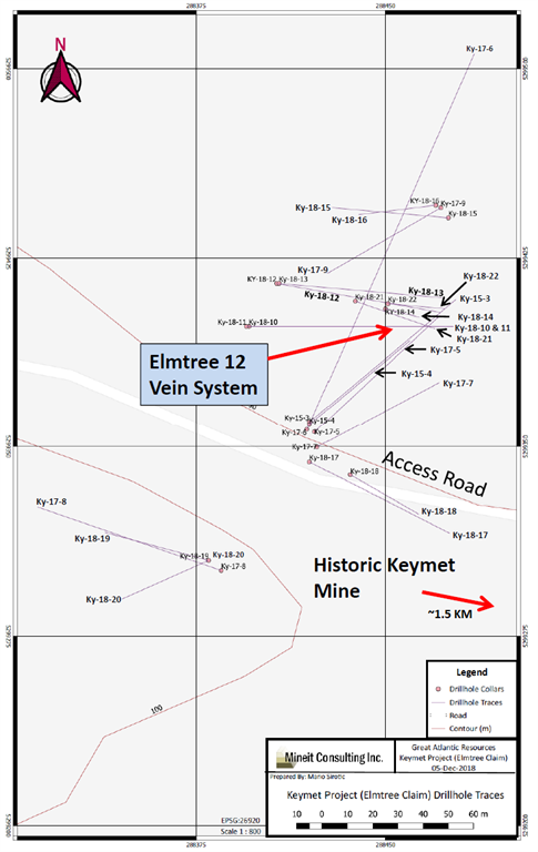
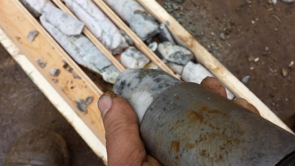
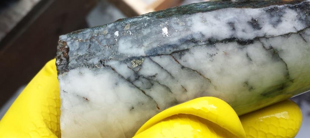
Drilling occurred in northwest region of the property, 1.5 km NW of the historic Keymet Mine.
Ky-18-14: 7.89% zinc equivalent over 34.3 meters (From 46.20 m to 80.50 m)
Elmtree 12 vein: System traced to approximately 145 meters depth, open at depth
Elmtree 12 vein: Strike length of approximately 110 meters and open along strike
The Company’s focus since acquiring the Keymet Property is the area of
reported polymetallic veins with most work in the area of the Elmtree 12
copper-lead-zinc-silver bearing vein system.
At
least seven vein occurrences with lead, zinc and +/- copper, silver and
gold are reported in this region of the property in addition to the
polymetallic veins reported at the historic Keymet Mine
FULL DISCLOSURE: Great Atlantic is an advertising client of AGORA Internet Relations Corp
Posted by AGORACOM
at 10:40 AM on Thursday, March 28th, 2019
3 prospecting licenses have been issued for the three claims that comprise the Advane Gold – Acacia Mining JV
Two of the claims are located on either side of Acacia Mining’s 100% owned ground on the Liranda corridor.
Acacia’s 100% owned ground Owns a resource estimate of 1.2 million ounces of gold with an average grade of 12.6 g/t.
Claim PL/2018/0211 has seen past drilling that returned a highlight hole of 6 metres of 30.9 g/t gold, April 18/2016
Vancouver, British Columbia–(Newsfile Corp. – March 28, 2019) –
Advance Gold Corp. (TSXV: AAX) (“Advance Gold” or “the Company”) is
pleased to announce that new prospecting licenses have been issued for
the three claims (PL/2018/0210, PL/2018/0211 and PL/2018/0212) that make
up the West Kenya, Advance Gold – Acacia Mining joint venture. Two of
the claims are located on either side of Acacia Mining’s 100% owned
ground on the Liranda corridor.
On Acacia’s 100% owned ground a
resource estimate (from the Isulu Shoot) was announced in February 2018,
consisting of 1.2 million ounces of gold with an average grade of 12.6
g/t. The Isulu Shoot zone is contiguous to Advance Gold’s license
PL/2018/0211 and PL/2018/0210. Mineralization hosted on Acacia’s
property is not necessarily indicative of the mineralization hosted on
the properties that make up the Advance-Acacia joint venture. In
addition, claim PL/2018/0211 has seen past drilling that returned a
highlight hole of 6 metres of 30.9 g/t gold, see April 18/2016 news
release.
The joint venture is owned 85.37% by Acacia and 14.63%
by Advance Gold. If during the joint venture either party decides to
sell their interest, the other party has a first right of refusal on any
offering price. If Advance Gold is diluted down to a 10% interest
(approximately $1.7 million in exploration to dilute), then its interest
converts to a 3% uncapped net smelter royalty (NSR). In the event that
Advance Gold is diluted to a NSR, Acacia Mining has no first rights of
refusal and the NSR can be sold directly to any interested party.
Allan Barry Laboucan, President and CEO of Advance Gold Corp. commented: “Management
is delighted with the new licenses for our strategically located claims
in Kenya that have been recently re-issued. The joint venture claims
have seen high-grade gold intersections in past drilling, and are
located on the Liranda corridor on either side of Acacia Mining’s
high-grade gold resource at their Isulu Shoot. Based on the past work at
the joint venture claims, including drilling, geophysics, and surface
sampling, the potential of the project is clear and why an Acacia Mining
sized company is our partner. Acacia Mining is 64% owned by Barrick
Gold Corporation, so it is fair to say from Barrick’s public statements
about deposit size, that they are looking for more than 1.2 million
ounces. A logical move by Acacia Mining will be to drill more
extensively on the joint venture ground so as to enhance Acacia Mining’s
known resource. Now that we have the new licenses, Advance Gold will
evaluate its options to participate in further exploration, or be
diluted down to a NSR. We are also considering the option to sell our
interest as we feel that it is an attractive asset for gold miners,
streamers and royalty companies that are hard pressed to put their cash
to work as there aren’t a lot of high-grade gold projects to choose
from.”
About the Liranda Corridor Claims
The
Liranda Corridor is found on the map below (from the Acacia Mining
corporate presentation Feb. 2019) and it has been the focus of Acacia’s
exploration in western Kenya.
On Acacia Mining’s 100% owned
ground, they have an inferred resource of 1.2 million ounces at 12.1 g/t
gold. The entire resource is on the Isulu Shoot and can be seen in the
upper right corner of the map and is highlighted in red. The Isulu Shoot
occurs in the same structures that extend onto the Advance Gold-Acacia
Mining joint venture ground.
Past drilling on the joint venture
ground, has returned some of the highest reported grades from the
Liranda corridor. Including highlight drill intersections of 6 metres of
30.9 g/t gold (drillhole – KDAC0152), see April 18/2016 news release.
Acacia
Mining has determined the scope of the resource on their 100% ground.
It is clear from the geological setting, the structural trends and past
drilling on the joint venture ground that it is a prime target area to
enhance the Acacia Mining resource.
Julio
Pinto Linares is a QP, Doctor in Geological Sciences with specialty in
Economic Geology and Qualified Professional No. 01365 by MMSA., for
Advance Gold and is the qualified person as defined by National
Instrument 43-101 responsible for the accuracy of technical information
contained in this news release.
Other News
The
company would like to report the retirement of Jim Gillis. He will be
stepping down as the Chairman of the Board and director and will be
replaced by current director Bradley Newell.
The board of
directors would like to thank Jim Gillis for his many years of guidance
and wish him all the best in his retirement.
In addition to
Bradley Newell being a director that has been helping guide the company,
he is also the largest individual shareholder.
About Advance Gold Corp. (TSXV: AAX)
Advance
Gold is a TSX-V listed junior exploration company focused on acquiring
and exploring mineral properties containing precious metals. The Company
acquired a 100% interest in the Tabasquena Silver Mine in Zacatecas,
Mexico in 2017, and the Venaditas project, also in Zacatecas state, in
April, 2018.
The Tabasquena project is located near the Milagros
silver mine near the city of Ojocaliente, Mexico. Benefits at Tabasquena
include road access to the claims, power to the claims, a 100-metre
underground shaft and underground workings,plus it is a fully permitted mine.
Venaditas
is well located adjacent to Teck’s San Nicholas mine, a VMS deposit,
and it is approximately 11km to the east of the Tabasquena project,
along a paved road.
In addition, Advance Gold holds a 14.63%
interest on strategic claims in the Liranda Corridor in Kenya, East
Africa. The remaining 85.37% of the Kakamega project is held by Acacia
Mining (63% owned by Barrick Gold Corporation).
For further information, please contact: Allan Barry Laboucan, President and CEO Phone: (604) 505-4753 Email: [email protected] Corporate website: www.advancegold.ca
Posted by AGORACOM
at 12:36 PM on Tuesday, March 19th, 2019
Completd a 21-hole diamond drilling program on the Refractory Zone of the La Loutre graphite property
Focus of the program was to expand a discovery announced March 7, 2017, and reviewed March 7, 2019 containing high grade intercepts of 7.74% Cg over 135.60 metres, including 16.81% Cgr over 44.10 metres from hole LL-16-001.
Two different intersections in hole LL-16-002 reporting 17.08% Cg over 22.30 metres and 14.80% Cg over 15.10 metres
Vancouver, B.C and Montreal, Que, March 19, 2019 (GLOBE NEWSWIRE) —
Lomiko Metals Inc. (TSX-V: LMR, LMRMF, FSE: DH8C, and Quebec Precious
Metals Corporation (TSX-V: CJC, FSE: YXEN, OTC-BB: CJCFF) are pleased to
announce the completion of a 21-hole diamond drilling program on the
Refractory Zone of the La Loutre graphite property (the “Propertyâ€).
“Our exploration team reports graphitic zones in multiple drill
holes.â€, stated A. Paul Gill, CEO of Lomiko Metals Inc. “It is very
encouraging to visually observe intercepts of graphitic material. We
look forward to receiving assays in three weeks and then advancing the
high-grade Refractory Zone to resource estimation stage.â€
The focus of the program was to expand a discovery announced March 7, 2017, and reviewed March 7, 2019 containing high grade intercepts of 7.74% Cg over 135.60 metres including 16.81% Cgr over 44.10 metres from hole LL-16-001, two different intersections in hole LL-16-002 reporting 17.08% Cg over 22.30 metres and 14.80% Cg over 15.10 metres, and 110.80 metres of 14.56% Cg in hole LL-16-003, and the 28.5 metres of 16.53% Cg and 21.5 metres of 11.53% Cg reported on January 6, 2016 and 9,0% over 90.75 metres reported on September 24th 2015 from the Refractory Zone.
The area of mineralization appears to be 200 metres wide and now has a
current strike length of approximately 900 metres in the west-southwest
to east-northeast direction and is open in both directions.
The table below shows the drilling results from LL-16-001 to
LL-16-010. A drill hole location map can be found under the heading
Quicklinks: Drill Map which includes 2015 and 2016 results and highlights.
Table of 2016 drill results – LL-16-001 to LL-16-010 from Refractory Zone:
Hole #
From (m)
To (m)
Length* (m)
Cg %**
LL-16-001
3.90
139.50
135.60
7.74
Incl.
3.90
48.00
44.10
16.81
Incl.
135.00
138.00
3.00
14.85
LL-16-002
3.90
26.20
22.30
17.08
Incl.
113.9
129.00
15.10
14.80
LL-16-003
30.20
141.00
110.80
14.56
LL-16-004
No significant values
LL-16-005
55.80
57.40
1.60
13.35
LL-16-06
54.00
141.00
85.00
7.67
Incl.
109.50
141.00
31.50
13.09
LL-16-007
52.50
115.80
63.30
8.51
Incl.
69.00
85.50
16.50
15.75
LL-16-008
109.50
121.50
12.00
3.91
LL-16-009
No significant values
LL-16-010
31.20
45.00
13.80
4.14
72.00
147.00
75.00
4.60
* True widths of the graphitic material are estimated to range from 80% to 95% of the down-hole length along the drill core.
** These results have been previously disclosed
The Property consists of contiguous claim blocks totaling
approximately 28.67 km2 situated approximately 53 km east of Imerys’
Carbon and Graphite operation, formerly known as the Timcal Graphite
Mine, North America’s only operating graphite mine, and located 117 km
northwest of Montreal.
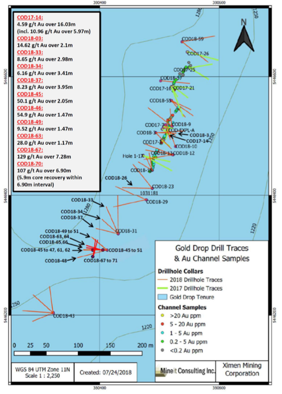
VANCOUVER, BC / ACCESSWIRE / March 18, 2019 / GGX Gold Corp. (TSX-V: GGX), (OTCQB: GGXXF), (FRA: 3SR2) (the “Company” or “GGX“)
is pleased to announce it has received tellurium analytical results for
select drill core samples from the Fall 2018 diamond drill program at
the Gold Drop Property, located in southern British Columbia. The Fall
2018 drill program was conducted at the C.O.D. Vein, located in the Gold
Drop Southwest Zone. The tellurium results are re-analyses of drill
core samples from drill holes COD18-67 and COD18-70 which initially
exceeded the upper 500 grams per tonne (g/t) analytical limit for
tellurium. The re-analyses confirm high-grade tellurium for these drill
holes, being associated with high-grade gold and silver (gold and silver
results reported in News Releases of January 11 and 18, 2019):
The
2018 Fall diamond drill program tested the COD vein. The program
followed up on results from previous 2018 diamond drilling at the
southern extension of the COD vein. The highlights of the 2018 Fall
drill program are drill hole COD18-67 which intersected 129.1 g/t gold
and 1,154 g/t silver over 7.28 meters core length and drill hole
COD18-70 which intersected 107.5 g/t gold and 880 g/t silver over 6.90
meters core length (News Releases of January 11and 18, 2019). Both holes
were drilled slightly northeast from the same site (COD18-67 at a
50-degree dip and COD-18-70 at a 54-degree dip) to intersect the
northwest trending COD Vein at a shallower angle, the objective to test
the continuity of the quartz veining and mineralization.
Fourteen
drill core samples from the high-grade gold and silver intersections of
drill holes COD18-67 and COD18-70 returned greater than the upper
analytical limit of 500 g/t for tellurium during initial analysis (four
acid ICP-MS analysis by ALS Canada Ltd. in North Vancouver). As a
result, the tellurium weighted average grades for these intersections
could not be determined from initial analyses. ALS Canada Ltd. recently
re-analyzed these 14 samples for tellurium by four acid ICP-AES. These
new analytical results confirm high grade tellurium within the
high-grade gold and silver intersections. For drill hole COD18-67, the
near-surface interval of 23.19-30.47m (7.28 meters core length) graded
823.4 g/t tellurium. For drill hole COD18-70, the near-surface interval
of 22.57-29.47m (6.90 meters core length) graded 640.5 g/t Tellurium.
The 14 drill samples are listed as follows (core length):
Hole No.
From (m)
To (m)
Length (m)
Te (G/T)
Sample No.
COD18-67
23.58
23.95
0.37
880
V108489
COD18-67
24.50
25.10
0.60
560
V108491
COD18-67
25.10
25.50
0.40
770
V108492
COD18-67
25.50
26.06
0.56
900
V108493
COD18-67
26.06
26.34
0.28
930
V108494
COD18-67
26.34
26.72
0.38
2,250
V108495
COD18-67
26.72
27.10
0.38
3,860
V108496
COD18-67
27.10
27.63
0.53
1,550
V108497
COD18-67
29.70
30.04
0.34
1,090
V108503
COD18-67
30.04
30.47
0.43
710
V108504
COD18-70
22.57
22.95
0.38
690
V108537
COD18-70
23.30
23.75
0.45
3,340
V108539
COD18-70
23.75
24.15
0.40
2,960
V108541
COD18-70
26.19
26.98
0.79
830
V108544
Intersections
for 2017 and 2018 diamond drill holes at the C.O.D. vein include the
following (please refer to the Company’s website for News Releases
announcing these results):
Hole ID
Interval Length (m)
Gold (gpt)
Silver (gpt)
Te (gpt)
COD17-14
16.03
4.59
38.64
COD18-3
2.1
14.62
150.2
102
COD18-26
1.4
10.3
1.09
0.24
COD18-32
1.51
3.67
67.2
30.4
COD18-33
2.98
8.65
47.6
37.3
COD18-34
3.41
6.16
72.4
31
COD18-37
3.95
8.23
67.36
38.53
COD18-45
2.05
50.15
375
COD18-46
1.47
54.9
379
COD18-49
1.47
9.52
118
72.2
COD18-54
1.66
7.6
60.2
34.1
COD18-61
1.38
5.29
32.4
31.4
COD18-63
1.17
28
424.7
150.4
COD18-67
7.28
129.1
1,154.90
823
COD18-68
2.76
8.77
85.4
56.3
COD18-69
7.46
5.76
67.9
61.2
COD18-70
6.9
107.5
880
640
Tellurium
remains as one of the rarest elements on earth. Tellurium production
has been a by-product of copper and gold mining. The production is
limited, estimated to being on the order of 800 metric tonnes per year.
According to the USGS total production for 2007 was 107 Mtonnes.
Up
to recently, the sole use of tellurium has been alloying of other
metals to increase the machinability of copper or to decrease the
corrosive action of sulfuric acid on lead.
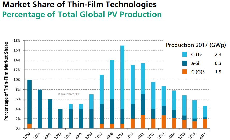
The most significant
modern use of tellurium is the Cadmium-telluride (Cd-Te) photovoltaic
solar cells. These solar cells are the forefront of solar power. One
gigawatt (GW) of Cd-Te, at current efficiencies, would require
approximately 93 metric tons of tellurium. These cells have the smallest
carbon footprint and the shortest energy payback time of all solar
cells. The efficiency of technology is constantly improving and the
Cd-Te now takes up 5.1% of worldwide PV production.
PHOTOVOLTAICS REPORT, Freiburg, 27 August 2018
In
the C.O.D vein system the tellurium occurs as a soft silver-grey
telluride mineral. The telluride mineral is a Silver-Tellurium-Gold
alloy speculated to be sylvanite. Whenever this mineral is observed in
the drill core the interval has elevated silver, gold and tellurium
values.
David Martin, P.Geo., a Qualified Person as defined by NI
43-101 and consultant for GGX Gold Corp., is responsible for the
technical information contained in this News Release.
To view the Original News release with pictures please go to the website or contact the Company.
On Behalf of the Board of Directors, Barry Brown, Director 604-488-3900
Tags: #Assay, #BC, #Discovery, #GoldDrop, #silver, $GGX, gold Posted in GGX Gold Corp. | Comments Off on $GGX.ca GGX Gold Drill Core Samples Return up to 3,860 G/T Tellurium at the C.O.D. Vein Southern British Columbia $APH.ca $TUE.ca $GOM.ca $TYE.ca $NNZ.ca $GTT.ca $AOT.ca $MTB.ca
Posted by AGORACOM
at 8:34 AM on Wednesday, March 13th, 2019
Labrador Gold controls 57 kilometre a strike length of stratigraphy prospective for gold in the Florence Lake Greenstone Belt. Hopedale Project
Exploration program at Hopedale followed up on successful results of 2017 work that outlined regional scale gold in soil and lake sediment anomalies
Of these samples, 80 assayed greater than 0.1 g/t gold including 17 samples that assayed greater than 1 g/t gold.
VANCOUVER,
British Columbia, March 13, 2019 (GLOBE NEWSWIRE) — Labrador Gold
Corp. (TSX-V: LAB) (“Labrador Gold†or the “Companyâ€) is pleased to
announce assay results for rock samples from its Hopedale project in
Labrador. The company controls a 57 kilometre strike length of
stratigraphy prospective for gold in the Florence Lake Greenstone Belt.
The exploration program at Hopedale followed up on successful results of
2017 work that outlined regional scale gold in soil and lake sediment
anomalies along the length of the belt and included detailed soil
sampling, geological mapping, rock sampling and prospecting.
A
total of 588 rock samples were taken along the length of the Florence
Lake Greenstone Belt during the regional prospecting and mapping
program. Of these samples, 80 assayed greater than 0.1 g/t gold
including 17 samples that assayed greater than 1 g/t gold. Results of
the assays ranged from below the detection limit of 0.05 g/t to 11.4 g/t
gold in a grab sample from a quartz vein with pyrite and arsenopyrite.
Additional highlights include channel samples of 2.77 g/t gold over 2.1
metres and 2.37 g/t gold over 2 metres. Highlights of gold assays of
grab samples include 4.55g/t gold from quartz porphyry and 2.52g/t and
2.46g/t gold from quartz veins that were altered or contained sulphide.
Complete highlights of the program are shown in the table below.
Sample ID
Area
Sample Type*
Length
Au g/t
Description
1685504 to 506
Thurber Dog
Channel
3.5
0.47
Quartz veins in Quartz porphyry
1685506
Thurber Dog
including
1
0.86
Quartz Porphyry
1685509 to 510
Thurber Dog
Channel
2
0.91
Felsic volcanic
1685509
Thurber Dog
including
1
1.27
Quartz vein
1685555 to 556
Thurber North
Channel
2
2.36
Quartz Porphyry
1685556
Thurber North
Including
1
2.73
Quartz Porphyry
1685566
Thurber North
Channel
0.5
0.92
Ferruginous quartz vein
1685589
Thurber North
Channel
0.56
0.48
Quartz vein with iron Carbonate
1685613
Thurber South
Channel
1.2
0.65
Carbonate altered mafic volcanic
1685632 to 633
Thurber South
Channel
2.1
2.77
Chlorite altered Mafic volcanic with quartz veins
1685632
Thurber South
including
1.2
3.99
Quartz vein with Fe oxide
1693835
Thurber Dog
Grab
n/a
1.01
Quartz vein with Arsenopyrite
1685854
Shirley
Grab
n/a
1.09
Phyllite with arsenopyrite
1690808
Thurber Dog
Grab
n/a
1.45
Felsic volcanic/Quartz Porphyry
1692276
Thurber South
Grab
n/a
1.64
Quartz Vein
1692279
Thurber South
Grab
n/a
1.74
Quartz Vein
1693836
Thurber North
Grab
n/a
1.84
Silicified ultramafic with quartz veining and arsenopyrite
1685851
Shirley
Grab
n/a
2.46
Quartz-carbonate vein with pyrite
1692283
Thurber South
Grab
n/a
2.52
Quartz vein with iron carbonate
1656525
Thurber North
Grab
n/a
4.55
Quartz porphyry
1693833
Thurber Dog
Grab
n/a
11.40
Quartz vein with pyrite and arsenopyrite
*Note that grab samples are select samples and are not necessarily representative of gold mineralization found on the property.
While
rock samples containing anomalous gold are found in many parts of the
greenstone belt, most of the samples above 0.1g/t gold occur in the
Jasmine/Shirley and Thurber Dog areas of the belt. At Jasmine/Shirley,
the gold mineralization is associated with altered mafic volcanic rocks
and phyllite that contain varying amounts of arsenopyrite from
disseminated grains to veins of massive arsenopyrite. The highest-grade
rocks in the area are from quartz veins with iron carbonate alteration.
At
Thurber Dog, gold mineralization is associated primarily with altered
porphyritic felsic volcanic rocks and quartz veins around the Thurber
Dog occurrence and in the Thurber North area. At Thurber South the
mineralization is associated with intensely carbonate altered ultramafic
and mafic volcanic rocks and associated quartz veins. The mineralized
rocks typically contain disseminated pyrite and, more rarely
arsenopyrite.
“The results of our prospecting
at Hopedale are very encouraging, especially since this was our first
systematic rock sampling of the greenstone belt.†said Roger Moss,
President and Chief Executive Officer of Labrador Gold. “Over 13% of the
samples taken along the length of the belt returned results of more
than 0.1 g/t gold and will be followed up in detail. In addition,
significantly anomalous gold mineralization previously identified over a
three kilometre strike length in the Thurber Dog portion of the belt
continues to show excellent potential.â€
All
samples were shipped to the Bureau Veritas preparation laboratory in
Timmins, Ontario, where they were crushed and split and a 500g sub
sample pulverized to 200 mesh. Pulps were sent to the Vancouver
laboratory for assay. Samples of 30g were analyzed for gold by fire
assay with an atomic absorption finish and another 15g sample for 36
elements by ultratrace ICP-MS (inductively coupled plasma-mass
spectrometry) following an aqua regia digestion. Overlimit samples
(greater than 10g/t Au) are re-assayed using fire assay with a
gravimetric finish. In addition to the QA-QC conducted by the
laboratory, the Company routinely submits blanks, field duplicates and
certified reference standards with batches of samples to monitor the
quality of the analyses.
Roger Moss, PhD., P.Geo., is the qualified person responsible for all technical information in this release.
The
company gratefully acknowledges the Newfoundland and Labrador Ministry
of Natural Resources’ Junior Exploration Assistance (JEA) Program for
its financial support for exploration of the Hopedale property.
About Labrador Gold:
Labrador
Gold is a Canadian based mineral exploration company focused on the
acquisition and exploration of prospective gold projects in the
Americas. In 2017 Labrador Gold signed a Letter of Intent under which
the Company has the option to acquire 100% of the 896 square kilometre
(km2) Ashuanipi property in northwest Labrador and the Hopedale (458 km2) property in eastern Labrador.
The
Hopedale property covers much of the Hunt River and Florence Lake
greenstone belts that stretch over 80 km. The belts are typical of
greenstone belts around the world but have been underexplored by
comparison. Initial work by Labrador Gold during 2017 show gold
anomalies in soils and lake sediments over a 3 kilometre section of the
northern portion of the Florence Lake greenstone belt in the vicinity of
the known Thurber Dog gold showing where grab samples assayed up to
7.8g/t gold. In addition, anomalous gold in soil and lake sediment
samples occur over approximately 40 kilometres along the southern
section of the greenstone belt (see news release dated January 25th 2018 for more details). Labrador Gold now controls approximately 57km strike length of the Florence Lake Greenstone Belt.
The
Ashuanipi gold project is located just 35 km from the historical iron
ore mining community of Schefferville, which is linked by rail to the
port of Sept Iles, Quebec in the south. The claim blocks cover large
lake sediment gold anomalies that, with the exception of local
prospecting, have not seen a systematic modern day exploration program.
Results of the 2017 reconnaissance exploration program following up the
lake sediment anomalies show gold anomalies in soils and lake sediments
over a 15 kilometre long by 2 to 6 kilometre wide north-south trend and
over a 14 kilometre long by 2 to 4 kilometre wide east-west trend. The
anomalies appear to be broadly associated with magnetic highs and do not
show any correlation with specific rock types on a regional scale (see
news release dated January 18th 2018). This suggests a
possible structural control on the localization of the gold anomalies.
Historical work 30 km north on the Quebec side led to gold intersections
of up to 2.23 grams per tonne (g/t) Au over 19.55 metres (not true
width) (Source: IOS Services Geoscientifiques, 2012, Exploration and
geological reconnaissance work in the Goodwood River Area, Sheffor
Project, Summer Field Season 2011). Gold in both areas appears to be
associated with similar rock types.
The Company has 56,264,022 common shares issued and outstanding and trades on the TSX Venture Exchange under the symbol LAB.
Posted by AGORACOM
at 8:18 AM on Thursday, March 7th, 2019
Requested tellurium re-analysis of select drill core samples from the Fall 2018 diamond drill program at the Gold Drop Property, located in southern British Columbia
Multiple drill core samples from drill holes COD18-67 and COD18-70 exceeded the upper 500 grams per tonne (g/t) analytical limit for tellurium.
The 2018 Fall diamond drill program tested the COD vein. The program followed up on results from previous 2018 diamond drilling at the southern extension of the COD vein. The highlights of the 2018 Fall drill program are drill hole COD18-67 which intersected 129 g/t gold and 1,154 g/t silver over 7.28 meters core length and drill hole COD18-70 which intersected 107.5 g/t gold and 880 g/t silver over 6.90 m
VANCOUVER, BC / ACCESSWIRE / March 7, 2019 / GGX Gold Corp. (TSX-v: GGX), (OTCQB: GGXXF), (FRA: 3SR2) (the “Company” or “GGX“)
is pleased to announce it has requested tellurium re-analysis of select
drill core samples from the Fall 2018 diamond drill program at the Gold
Drop Property, located in southern British Columbia. The Fall 2018
drill program was conducted at the C.O.D. Vein, located in the Gold Drop
Southwest Zone. Multiple drill core samples from drill holes COD18-67
and COD18-70 exceeded the upper 500 grams per tonne (g/t) analytical
limit for tellurium. These samples returned high grade values for gold
and silver. These samples will be re-analyzed to determine tellurium
grades. Highlights from the Fall 2018 drill program include (News
Releases of January 11 and 18, 2019):
The
2018 Fall diamond drill program tested the COD vein. The program
followed up on results from previous 2018 diamond drilling at the
southern extension of the COD vein. The highlights of the 2018 Fall
drill program are drill hole COD18-67 which intersected 129 g/t gold and
1,154 g/t silver over 7.28 meters core length and drill hole COD18-70
which intersected 107.5 g/t gold and 880 g/t silver over 6.90 meters
core length (News Releases of January 11 and 18, 2019). Intersections
for 2017 and 2018 diamond drill holes at the C.O.D. vein include the
following (please refer to the Company’s website for News Releases
announcing these results):
Hole ID
Interval Length
Gold (gpt)
Silver (gpt)
Te (gpt)
COD17-14
16.03
4.59
38.64
COD18-3
2.1
14.62
150.2
102
COD18-26
1.4
10.3
1.09
0.24
COD18-32
1.51
3.67
67.2
30.4
COD18-33
2.98
8.65
47.6
37.3
COD18-34
3.41
6.16
72.4
31
COD18-37
3.95
8.23
67.36
38.53
COD18-45
2.05
50.15
375
COD18-46
1.47
54.9
379
COD18-49
1.47
9.52
118
72.2
COD18-54
1.66
7.6
60.2
34.1
COD18-61
1.38
5.29
32.4
31.4
COD18-63
1.17
28
424.7
150.4
COD18-67
7.28
129.11
1,154.90
COD18-68
2.76
8.77
85.4
56.3
COD18-69
7.46
5.76
67.9
61.2
COD18-70
6.9
107.5
880
Fourteen
drill core samples from the high-grade gold and silver intersections of
drill holes COD-18-67 and COD-18-70 returned greater than the upper
analytical limit of 500 g/t for tellurium during initial analysis (four
acid ICP-MS analysis by ALS Canada Ltd. in North Vancouver). As a
result, the tellurium weighted average grade for these intersections
could not be determined. The Company has requested ALS Canada Ltd. to
re-analyze these samples for tellurium.
Tellurium
(Te) remains as one of the rarest elements on earth. Tellurium
production has been a by-product of copper and gold mining. The
production is limited, estimated to being on the order of 800 metric
tonnes per year. According to the USGS total production for 2007 was 107
Mtonnes.
Up to recently, the sole use of tellurium has been
alloying of other metals to increase the machinability of copper or to
decrease the corrosive action of sulfuric acid on lead.
The most
significant modern use of tellurium is the Cadmium-telluride (Cd-Te)
photovoltaic solar cells. These solar cells are the forefront of solar
power. One gigawatt (GW) of Cd-Te, at current efficiencies, would
require approximately 93 metric tons of tellurium. These cells have the
smallest carbon footprint and the shortest energy payback time of all
solar cells. The efficiency of technology is constantly improving and
the Cd-Te now takes up 5.1% of worldwide PV production.
PHOTOVOLTAICS REPORT, Freiburg, 27 August 2018 (To view the full-size image, please click here)
In
the C.O.D vein system the tellurium occurs as a soft silver-grey
telluride mineral. The telluride mineral is a Silver-Tellurium-Gold
alloy speculated to be sylvanite. Whenever this mineral is observed in
the drill core the interval has elevated silver, gold and tellurium
values.
David Martin, P.Geo., a Qualified Person as defined by NI
43-101, is responsible for the technical information contained in this
News Release.
To view the Original News release with pictures please go to the website or contact the Company.
On Behalf of the Board of Directors, Barry Brown, Director 604-488-3900 [email protected]
Tags: #BC, #CODVein, #Discovery, #HighGrade, #silver, #tellerium, gold Posted in GGX Gold Corp. | Comments Off on GGX Gold Requests Tellurium Re-Analysis of Select 2018 High Grade Drill Core Samples at the C.O.D. Vein – Southern British Columbia $APH.ca $TUE.ca $GOM.ca $TYE.ca $NNZ.ca $GTT.ca $AOT.ca $MTB.ca
Posted by AGORACOM
at 1:39 PM on Tuesday, March 5th, 2019
Advance Gold has Identified up to 30 Epithermal veins through the first 2 stages of drilling.
AGT-02 Tabasquena intersected 19m of core and is discovery hole of 1.7m of 9.64g/t gold in first 10 metres assayed.
La Chiquita – 4.70m Intersection from (109.25 to 113.95) in AGT-04
AGT-04 Intersected new Vein Yaki for 0.8m, crosscutting La Chiquita vein for 4.70m,the Tabasquena vein for 10 metres in the oxide zone & the La Nina vein for 11m (129-140m depth)
Phase 3 Drilling
In the first two phases of drilling, Advance discovered a cluster of epithermal veins, all but a few of them blind, which suggests this drilling intersected the top of the epithermal vein system.
The results from the 2 phases of drilling returned significant gold mineralization (see Press Releases November 1, 2018 and November 6, 2018)
A key focus of the phase 3 drilling will be to drill deeper and target the boiling zone of the epithermal vein system. The cluster of veins dip toward a fault which is considered a key structural feature.
A proposed hole will start from the east side of the fault, drill west, to then go through the cluster of veins to catch them at the boiling zone.
Posted by AGORACOM
at 12:20 PM on Friday, March 1st, 2019
Acquired the Golden Trust Property through staking
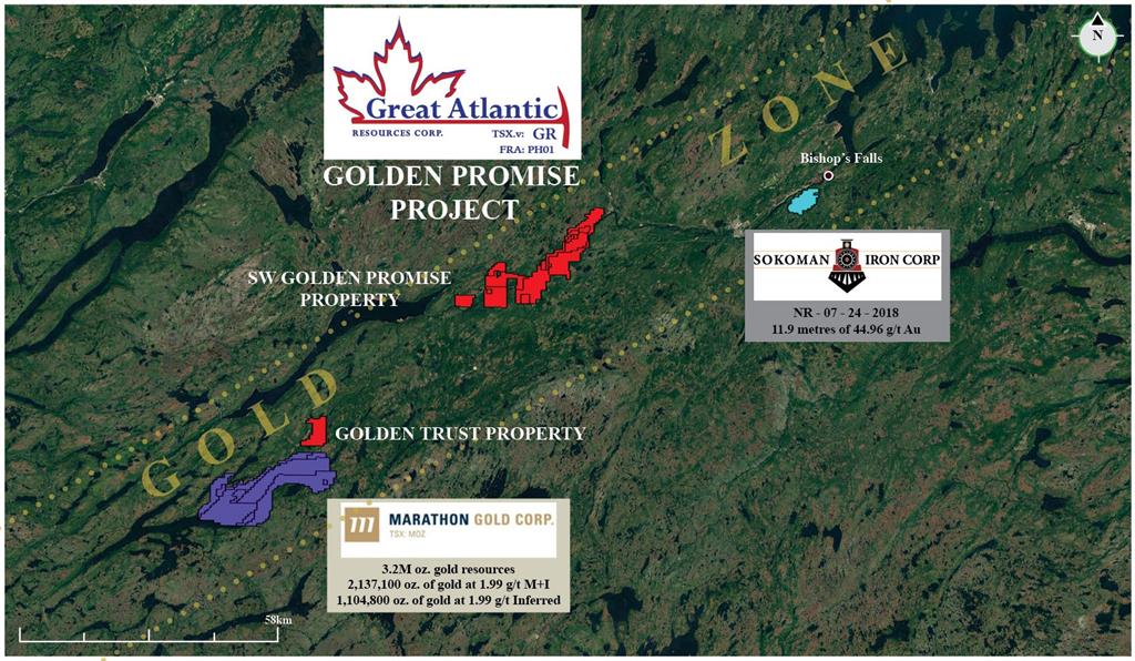
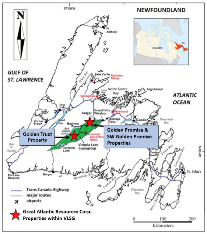
1 kilometer north of the Valentine Lake Gold Camp of Marathon Gold Corp.
Golden Trust Property covers an area of 2,400 hectares in a relatively under-explored area of the central Newfoundland gold belt
VANCOUVER, BC / ACCESSWIRE / March 1, 2019 / GREAT ATLANTIC RESOURCES CORP. (TSXV:GR) (the “Company” or “Great Atlantic”) is pleased to announce it has acquired, through staking, the Golden Trust Property, located in the central Newfoundland gold belt and 1 kilometer north of the Valentine Lake Gold Camp of Marathon Gold Corp. has acquired, through staking, the Golden Trust Property (TSXV:MOZ). The Golden Trust Property covers an area of 2,400 hectares in a relatively under-explored area of the central Newfoundland gold belt. Key points for the Golden Trust Property include:
Located
1 km north of the Valentine Lake Gold Camp of Marathon Gold Corp.,
approximately 44 km southwest of Great Atlantic’s Golden Promise
Property and approximately 31 km southwest of the Duck Pond VMS deposit.
Within
the prospective Victoria Lake Supergroup which hosts numerous
epigenetic gold & volcanogenic massive sulfide occurrences
(including Duck Pond VMS deposit).
Within
the Exploits Subzone of the Dunnage Zone and east of the Red Indian
Line (RIL), a major (Appalachian-scale) collisional boundary, and suture
zone.
Government till samples (2008) returned elevated to anomalous values for gold in various regions of the Golden Trust Property.
The
Golden Trust Property occurs within an under-explored area of the
Newfoundland central gold belt. Company management have been unable to
locate any reports of historic diamond drilling within the property.
Till geochemical sampling conducted by the Newfoundland Department of
Natural Resources in 2008 included a small number of wide-spaced samples
within the Golden Trust Property. Samples from various regions of the
property returned elevated to anomalous values for gold including in the
5-9 parts per billion range.
The southern boundary of the
property is located 1 kilometer north of the northeast region of the
Valentine Lake Gold Camp of Marathon Gold Corp. (TSXV:MOZ).
As reported on Marathon’s website, the Valentine Lake Gold Camp
currently hosts four near-surface, mainly pit-shell constrained,
deposits with measured and indicated resources totaling 2,691,400 oz. of
gold at 1.85 g/t gold and inferred resources totalling 1,531,600 oz. of
gold at 1.77 g/t. The Golden Trust Property is located approximately 44
kilometers southwest of Great Atlantic’s Golden Promise Gold Property
which hosts multiple gold bearing quartz vein systems.
The
Company’s Golden Trust and Golden Promise Properties and the Valentine
Lake Gold Camp of Marathon Gold Corp. all occur within the Exploits
Subzone of the Dunnage Zone. The Red Indian Line (RIL), a major
(Appalachian-scale) collisional boundary, and suture zone, forms the
western boundary of the Exploits Subzone.
The Golden Trust
Property occurs within the Victoria Lake Supergroup (VLSG), a
volcano-sedimentary terrane within the Exploits Subzone. The VLSG hosts
numerous volcanogenic massive sulfide (VMS) and epigenetic gold
occurrences. The most significant of the VMS deposits within the VLSG is
the Duck Pond deposit (zinc, lead, copper, silver and gold), located
approximately 31 kilometers northeast of the Golden Trust Property.
Readers
are warned that mineralization at the Valentine Lake Gold Camp, Golden
Promise Property, Duck Pond Deposit and elsewhere within the Exploits
Subzone and VLSG is not necessarily indicative of mineralization within
the Golden Trust Property.
David Martin, P.Geo., a Qualified
Person as defined by NI 43-101 and VP Exploration for Great Atlantic, is
responsible for the technical information contained in this News
Release.
About Great Atlantic Resources Corp.: Great
Atlantic Resources Corp. is a Canadian exploration company focused on
the discovery and development of mineral assets in the resource-rich and
sovereign risk-free realm of Atlantic Canada, one of the number one
mining regions of the world. Great Atlantic is currently surging forward
building the company utilizing a Project Generation model, with a
special focus on the most critical elements on the planet that are
prominent in Atlantic Canada, Antimony, Tungsten and Gold.
On Behalf of the board of directors
“Christopher R Anderson”
Mr. Christopher R. Anderson “Always be positive, strive for solutions, and never give up” President CEO Director 604-488-3900 – Dir