Agoracom Blog Home

Posts Tagged ‘#Drilling’

LABRADOR GOLD $LAB.ca – On the Path to Discovery in Labrador $RIO.ca $WHM.ca $SIC.ca

Posted by AGORACOM at 8:02 AM on Monday, April 22nd, 2019
https://s3.amazonaws.com/s3.agoracom.com/public/companies/logos/564640/hub/Small-Logo-Labrador-GOLD.jpg
  • Two field programs in Labrador over 2 seasons 26,000 soil samples, 1,547 lake sediment samples and 728 rock samples over area that covered 1,701 square kilometres,
  • Narrowed exploration focus to the two most prospective properties having identified regional scale gold anomalies on both
  • Ashuanipi: anomalies identified a 15 kilometre long by 2 to 6 kilometre wide north-south trend and a second 14 kilometre long by 2 to 4 kilometre wide east-west trend.
  • Hopedale project successfully identified gold mineralization over a three km segment of the northern Florence Lake greenstone belt known as Thurber Dog.
  • Gold anomalies also occurred along the entire 40km length of the southern Florence Lake greenstone belt.
  • Summer 2019 – Evaluate multiple compelling targets and undertake the first drilling for gold on either property.

March 28, 2019

It has been less than two years since I met Shawn Ryan and launched Labrador Gold and yet we have accomplished so much in that short time. We raised over $5 million, and in the process attracted investors such as Mr. Rob McEwen, Chairman and Chief Owner of McEwen Mining Inc., Plethora Precious Metals Fund, RyanWood principals Shawn Ryan and Cathy Wood, as well as friends and associates of management. We completed two field programs in Labrador, taking over 26,000 soil samples, 1,547 lake sediment samples and 728 rock samples. Following the first program we narrowed our focus to the two most prospective properties having identified regional scale gold anomalies on both. This year we will evaluate multiple compelling targets and undertake the first drilling to be carried out for gold on either property.

Both Shawn and I started in the mining industry when companies still did grassroots, reconnaissance scale exploration as a matter of course. We routinely used stream sediment sampling, soil sampling, till sampling and prospecting over large properties to continuously narrow down the search to the most prospective areas. Done correctly, it is an unbiased means of rapidly assessing the exploration potential of a region and it works. Shawn used soil sampling as the primary means for discovering gold deposits in the Yukon that add up to over 7.5 million ounces. I was part of team that used soil sampling to find the Navachab gold deposit in Namibia, which still had resources of 3.9 million ounces in 2014 following 15 years of production. Based on these successes it made sense to apply the same method to the Labrador properties.

Labrador Gold is the first company to take such a systematic approach to gold exploration in Labrador. Shawn used publicly available data, including mineral occurrences and assays of lake sediments, soil samples, and rock samples to stake three properties that covered 1,701 square kilometres, an area just smaller than the Indian Ocean island of Mauritius. We started narrowing the area down in 2017 with regional scale soil and lake sediment sampling and limited prospecting. The results were encouraging.

Two of the properties, Hopedale and Ashuanipi, showed significant gold anomalies in both soils and lake sediments with values up to 2.1g/t in the soil samples. At Ashuanipi the anomalies identified a 15 kilometre long by 2 to 6 kilometre wide north-south trend and a second 14 kilometre long by 2 to 4 kilometre wide east-west trend. The anomalies are broadly associated with magnetic highs and do not show any correlation with specific rock types suggesting a structural control on the localization of the gold anomalies. As a result of the successful program we added claims to the northern claim block in both Labrador and Quebec to cover potential extensions of the anomalies.

Gold in soil anomalies at the Hopedale project successfully picked up known gold mineralization over a three km segment of the northern Florence Lake greenstone belt known as Thurber Dog indicating that the technique works in Labrador. What was particularly exciting was that gold anomalies also occurred along the entire 40km length of the southern Florence Lake greenstone belt. This belt has many characteristics of greenstone belts elsewhere in the world including major crustal scale structures, greenschist facies metamorphism, the presence of felsic porphyries and granitic intrusions and similar volcanic rocks. In terms of size, it is intermediate between the Kirkland Lake and Timmins gold camps of Ontario. Such greenstone belts are prolific hosts of gold elsewhere in the world. As such, and based on our results so far, it is quite possible that future exploration may result in the discovery of one or more gold deposits at Florence Lake. In terms of exploration maturity, Florence Lake is at the stage the Timmins camp was over a hundred years ago.

Encouraged by the success of our 2017 field work, we planned a follow up program of detailed soil sampling on grids with lines spaced at 100 metres and sample intervals of 25 metres along the lines. This would allow better resolution of potential gold mineralization highlighted by the samples. At Ashuanipi, we took 7,475 soil samples on 18 grids across the Ashuanipi north claim block and along 61 reconnaissance soil lines over the claims staked in 2018. Results of analyses showed significant gold anomalies in all but two of the 18 grids and confirmed the 15km north-south anomalous trend with values up to 8,970 ppb Au (8.97g/t) and 67 samples containing more than 100 ppb (0.1g/t) Au. These results suggest a robust mineralized system that is regional in extent with elevated values indicating potential sites of near surface gold mineralization.

At Hopedale, we took more than 10,000 soil samples on 12 grids along the length of the Florence Lake greenstone belt covering anomalous gold-in-soil targets with favorable geology and structure. Results showed 34 samples with values greater than 100 ppb (0.1g/t) Au, with five of these samples grading greater than 1,000 ppb (1g/t) Au. Elevated gold values were found in samples from all 12 grids. The highest concentrations of samples with anomalous gold are found in the Thurber Dog, Jasmine and Misery grids. The anomalies extend along strike for 5km at Thurber Dog and 1.8km at Misery. Rock samples collected during mapping and prospecting showed 80 samples with values greater than 0.1 g/t gold including 17 samples that assayed greater than 1 g/t gold with a high of 11.4 g/t gold in a select grab sample from a quartz vein with pyrite and arsenopyrite mineralization.

Our first two field seasons using systematic sampling to narrow down areas of potential gold mineralization have been a success. Three areas were identified for further follow up on each of the Hopedale and Ashuanipi properties. Compilation and interpretation of all data including new aeromagnetic data, will refine these areas to ensure efficient, targeted assessment of their potential in the field. Initial follow up will include detailed mapping and rock sampling of each area. Once we receive the assays we expect to begin a drilling program on the most prospective targets in late summer.

The significant decline in discovery rates worldwide over the past decade calls for a more disciplined approach to exploration with longer term thinking. We have embraced this idea with our work in Labrador over the past two years and with the support of our shareholders have made big strides towards discovery. Based on our results to date I have a feeling that the 2019 field season will be an exciting one. I hope you will join us for the ride.

Maps and images from the Hopedale and Ashuanipi properties can be found at: https://www.labradorgold.com/projects/

Follow us on Twitter: @LabGoldCorp

Roger Moss

President and CEO

Labrador Gold Corp.

416-704-8291


CLIENT FEATURE: $AAX.ca Advance Gold Prepares for Phase 3 Drilling at Tabasquena $MGG.ca SIL.ca $FA.ca

Posted by AGORACOM at 10:50 AM on Friday, April 12th, 2019
https://s3.amazonaws.com/s3.agoracom.com/public/companies/logos/564631/hub/advance-gold-large.png

Phase 1: Drilling Identified 4 Epithermal Veins -3 Have Demonstrated Greater Thickness at Depth

Phase 2: Drilling Identified 30 new Epithermal veins in 2 drill holes

  • In the first two phases of drilling, Advance discovered a cluster of epithermal veins, all but a few of them blind, which suggests this drilling intersected the top of the epithermal vein system.
  • A key focus of the phase 3 drilling will be to drill deeper and target the boiling zone of the epithermal vein system. The cluster of veins dip toward a fault which is considered a key structural feature.
  • A proposed hole will start from the east side of the fault, drill west, to then go through the cluster of veins to catch them at the boiling zone.
  • The other key focus will be to drill a few shallow holes near a 12 metre intersection of the Tabasquena vein in the oxides. This vein in the oxides is much wider than the historical 2-4 metre mining width utilized by former operator Penoles, which was across 2-4 metres. This intersection was a 125 metre step out to the north of the old mine workings and is approximately 75 metres along strike from the 100 metre deep shaft and headframe.
  • Advance has mining equipment and the Tabasquena project is fully permitted for mining.
http://i65.tinypic.com/6fyux0.png


FULL DISCLOSURE: Advance Gold is an advertising client of AGORA Internet Relations Corp

CLIENT FEATURE: Advance Gold $AAX.ca Starts Phase 3 Drilling at the Tabasquena $MGG.ca SIL.ca $FA.ca

Posted by AGORACOM at 11:14 AM on Tuesday, April 2nd, 2019
https://s3.amazonaws.com/s3.agoracom.com/public/companies/logos/564631/hub/advance-gold-large.png

Phase 1: Drilling Identified 4 Epithermal Veins -3 Have Demonstrated Greater Thickness at Depth

Phase 2: Drilling Identified 30 new Epithermal veins in 2 drill holes

Phase 3 Drilling:

  • In the first two phases of drilling, Advance discovered a cluster of epithermal veins, all but a few of them blind, which suggests this drilling intersected the top of the epithermal vein system.
  • A key focus of the phase 3 drilling will be to drill deeper and target the boiling zone of the epithermal vein system. The cluster of veins dip toward a fault which is considered a key structural feature.
  • A proposed hole will start from the east side of the fault, drill west, to then go through the cluster of veins to catch them at the boiling zone.
  • The other key focus will be to drill a few shallow holes near a 12 metre intersection of the Tabasquena vein in the oxides. This vein in the oxides is much wider than the historical 2-4 metre mining width utilized by former operator Penoles, which was across 2-4 metres. This intersection was a 125 metre step out to the north of the old mine workings and is approximately 75 metres along strike from the 100 metre deep shaft and headframe.
  • Advance has mining equipment and the Tabasquena project is fully permitted for mining.

FULL DISCLOSURE: Advance Gold is an advertising client of AGORA Internet Relations Corp

LABRADOR GOLD $LAB.ca – On the Path to Discovery in Labrador $RIO.ca $WHM.ca $SIC.ca

Posted by AGORACOM at 10:35 AM on Monday, April 1st, 2019
https://s3.amazonaws.com/s3.agoracom.com/public/companies/logos/564640/hub/Small-Logo-Labrador-GOLD.jpg
  • Two field programs in Labrador over 2 seasons
  • 26,000 soil samples, 1,547 lake sediment samples and 728 rock samples over area that covered 1,701 square kilometres,
  • Narrowed exploration focus to the two most prospective properties having identified regional scale gold anomalies on both
  • Ashuanipi: anomalies identified a 15 kilometre long by 2 to 6 kilometre wide north-south trend and a second 14 kilometre long by 2 to 4 kilometre wide east-west trend.
  • Hopedale project successfully identified gold mineralization over a three km segment of the northern Florence Lake greenstone belt known as Thurber Dog, gold anomalies also occurred along the entire 40km length of the southern Florence Lake greenstone belt.
  • Summer 2019 – Evaluate multiple compelling targets and undertake the first drilling for gold on either property.

March 28, 2019

It has been less than two years since I met Shawn Ryan and launched Labrador Gold and yet we have accomplished so much in that short time. We raised over $5 million, and in the process attracted investors such as Mr. Rob McEwen, Chairman and Chief Owner of McEwen Mining Inc., Plethora Precious Metals Fund, RyanWood principals Shawn Ryan and Cathy Wood, as well as friends and associates of management. We completed two field programs in Labrador, taking over 26,000 soil samples, 1,547 lake sediment samples and 728 rock samples. Following the first program we narrowed our focus to the two most prospective properties having identified regional scale gold anomalies on both. This year we will evaluate multiple compelling targets and undertake the first drilling to be carried out for gold on either property.

Both Shawn and I started in the mining industry when companies still did grassroots, reconnaissance scale exploration as a matter of course. We routinely used stream sediment sampling, soil sampling, till sampling and prospecting over large properties to continuously narrow down the search to the most prospective areas. Done correctly, it is an unbiased means of rapidly assessing the exploration potential of a region and it works. Shawn used soil sampling as the primary means for discovering gold deposits in the Yukon that add up to over 7.5 million ounces. I was part of team that used soil sampling to find the Navachab gold deposit in Namibia, which still had resources of 3.9 million ounces in 2014 following 15 years of production. Based on these successes it made sense to apply the same method to the Labrador properties.

Labrador Gold is the first company to take such a systematic approach to gold exploration in Labrador. Shawn used publicly available data, including mineral occurrences and assays of lake sediments, soil samples, and rock samples to stake three properties that covered 1,701 square kilometres, an area just smaller than the Indian Ocean island of Mauritius. We started narrowing the area down in 2017 with regional scale soil and lake sediment sampling and limited prospecting. The results were encouraging.

Two of the properties, Hopedale and Ashuanipi, showed significant gold anomalies in both soils and lake sediments with values up to 2.1g/t in the soil samples. At Ashuanipi the anomalies identified a 15 kilometre long by 2 to 6 kilometre wide north-south trend and a second 14 kilometre long by 2 to 4 kilometre wide east-west trend. The anomalies are broadly associated with magnetic highs and do not show any correlation with specific rock types suggesting a structural control on the localization of the gold anomalies. As a result of the successful program we added claims to the northern claim block in both Labrador and Quebec to cover potential extensions of the anomalies.

Gold in soil anomalies at the Hopedale project successfully picked up known gold mineralization over a three km segment of the northern Florence Lake greenstone belt known as Thurber Dog indicating that the technique works in Labrador. What was particularly exciting was that gold anomalies also occurred along the entire 40km length of the southern Florence Lake greenstone belt. This belt has many characteristics of greenstone belts elsewhere in the world including major crustal scale structures, greenschist facies metamorphism, the presence of felsic porphyries and granitic intrusions and similar volcanic rocks. In terms of size, it is intermediate between the Kirkland Lake and Timmins gold camps of Ontario. Such greenstone belts are prolific hosts of gold elsewhere in the world. As such, and based on our results so far, it is quite possible that future exploration may result in the discovery of one or more gold deposits at Florence Lake. In terms of exploration maturity, Florence Lake is at the stage the Timmins camp was over a hundred years ago.

Encouraged by the success of our 2017 field work, we planned a follow up program of detailed soil sampling on grids with lines spaced at 100 metres and sample intervals of 25 metres along the lines. This would allow better resolution of potential gold mineralization highlighted by the samples. At Ashuanipi, we took 7,475 soil samples on 18 grids across the Ashuanipi north claim block and along 61 reconnaissance soil lines over the claims staked in 2018. Results of analyses showed significant gold anomalies in all but two of the 18 grids and confirmed the 15km north-south anomalous trend with values up to 8,970 ppb Au (8.97g/t) and 67 samples containing more than 100 ppb (0.1g/t) Au. These results suggest a robust mineralized system that is regional in extent with elevated values indicating potential sites of near surface gold mineralization.

At Hopedale, we took more than 10,000 soil samples on 12 grids along the length of the Florence Lake greenstone belt covering anomalous gold-in-soil targets with favorable geology and structure. Results showed 34 samples with values greater than 100 ppb (0.1g/t) Au, with five of these samples grading greater than 1,000 ppb (1g/t) Au. Elevated gold values were found in samples from all 12 grids. The highest concentrations of samples with anomalous gold are found in the Thurber Dog, Jasmine and Misery grids. The anomalies extend along strike for 5km at Thurber Dog and 1.8km at Misery. Rock samples collected during mapping and prospecting showed 80 samples with values greater than 0.1 g/t gold including 17 samples that assayed greater than 1 g/t gold with a high of 11.4 g/t gold in a select grab sample from a quartz vein with pyrite and arsenopyrite mineralization.

Our first two field seasons using systematic sampling to narrow down areas of potential gold mineralization have been a success. Three areas were identified for further follow up on each of the Hopedale and Ashuanipi properties. Compilation and interpretation of all data including new aeromagnetic data, will refine these areas to ensure efficient, targeted assessment of their potential in the field. Initial follow up will include detailed mapping and rock sampling of each area. Once we receive the assays we expect to begin a drilling program on the most prospective targets in late summer.

The significant decline in discovery rates worldwide over the past decade calls for a more disciplined approach to exploration with longer term thinking. We have embraced this idea with our work in Labrador over the past two years and with the support of our shareholders have made big strides towards discovery. Based on our results to date I have a feeling that the 2019 field season will be an exciting one. I hope you will join us for the ride.

Maps and images from the Hopedale and Ashuanipi properties can be found at: https://www.labradorgold.com/projects/

Follow us on Twitter: @LabGoldCorp

Roger Moss

President and CEO

Labrador Gold Corp.

416-704-8291

Client Feature: GGX Gold 2019 Diamond Drilling Program on the Gold Drop Property $GGX.ca $APH.ca $TUE.ca $GOM.ca $TYE.ca $NNZ.ca $GTT.ca $AOT.ca $MTB.ca

Posted by AGORACOM at 9:56 AM on Monday, April 1st, 2019
https://s3.amazonaws.com/s3.agoracom.com/public/companies/logos/564602/hub/ggx_large.png
  • In early April the spring drilling program will focus on the COD vein located in the Gold Drop Southwest Zone
  • 2018 drilling discovered COD18-67: 129 g/t gold, 1,154 g/t silver & 823 g/t tellurium over 7.28 meters core length.
    COD18-70: 107 g/t gold, 880 g/t silver & 640 g/t tellurium over 6.90 meters core length.
https://www.accesswire.com/users/newswire/images//03202019GGX2.png

FULL DISCLOSURE: GGX Gold is an advertising client of AGORA Internet Relations Corp.

CLIENT FEATURE: $GR.ca Great Atlantic’s Keymet Base Metal Property Proving Success Comes through Drilling $SIC.ca $MOZ.ca

Posted by AGORACOM at 8:15 AM on Monday, April 1st, 2019
https://s3.amazonaws.com/s3.agoracom.com/public/companies/logos/564603/hub/GREATATLANTIC_LOGO_TESTER-e1480712241913.jpg
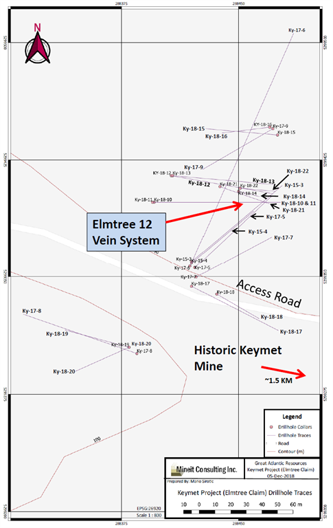
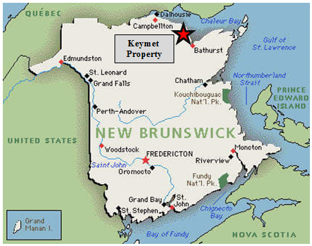
  • Drilling occurred in northwest region of the property, 1.5 km NW of the historic Keymet Mine.
  • Ky-18-14: 7.89% zinc equivalent over 34.3 meters (From 46.20 m to 80.50 m)
  • Elmtree 12 vein: System traced to approximately 145 meters depth, open at depth
  • Elmtree 12 vein: Strike length of approximately 110 meters and open along strike
  • The Company’s focus since acquiring the Keymet Property is the area of reported polymetallic veins with most work in the area of the Elmtree 12 copper-lead-zinc-silver bearing vein system.
  • At least seven vein occurrences with lead, zinc and +/- copper, silver and gold are reported in this region of the property in addition to the polymetallic veins reported at the historic Keymet Mine
https://www.accesswire.com/users/newswire/images/532984/01182019GR3.png
https://www.accesswire.com/users/newswire/images/532984/01182019GR5.png

FULL DISCLOSURE: Great Atlantic is an advertising client of AGORA Internet Relations Corp

Advance Gold $AAX.ca Starts Phase 3 Drilling at the Tabasquena Project in Zacatecas, Mexico $MGG.ca $SIL.ca $FA.ca

Posted by AGORACOM at 5:26 PM on Friday, March 29th, 2019
https://s3.amazonaws.com/s3.agoracom.com/public/companies/logos/564631/hub/advance-gold-large.png
  • phase 3 drilling is underway at the Tabasquena mine in the state of Zacatecas, Mexico
  • Two targets are planned to be drilled:
  • One target is a near surface, the other a deeper test for the boiling zone of the cluster of epithermal veins drilled in the two earlier phases of drilling.
  • Advance discovered a cluster of epithermal veins through drilling, all but a few of them blind. This suggests drilling intersected the top of the epithermal vein system.

Vancouver, British Columbia–(Newsfile Corp. – March 22, 2019) – Advance Gold Corp. (TSXV: AAX) (“Advance Gold” or “the Company”) is pleased to announce phase 3 drilling is underway at the Tabasquena mine in the state of Zacatecas, Mexico. Two targets are planned to be drilled during this program, one is a near surface target and the other deeper to test the boiling zone of the cluster of epithermal veins drilled in the two earlier phases of drilling.

Highlights of Phase 1 and 2 Drilling

Advance discovered a cluster of epithermal veins through drilling, all but a few of them blind. This suggests drilling intersected the top of the epithermal vein system. From a regional perspective, most of the veins found near the city of Fresnillo, including those found at the Fresnillo Plc. and Mag Silver Juanicipio joint venture are blind.

Often, at the top of an epithermal vein system, anomalous to low grade is expected, which was found in phase 1 and 2 drilling. Also present in the core is milky quartz and amethyst, another important indicator of being at the top of an epithermal vein system. Importantly, crustiform and colloform quartz was encountered which are indicative of a long lived, multiple phase system.

Phase 3 Drilling Plans

Two shallow holes, around 150 metres each, are planned to test the near term production potential in the oxide zone of the Tabasquena vein. In the phase 2 drilling, a 12 metre intersection of the Tabasquena vein in the oxides was hit. This vein in the oxides is much wider than the historical 2-4 metre mining widths utilized by former operator Penoles. This intersection was a 125 metre step out to the north of the old mine workings and is approximately 75 metres along strike from the 100 metre deep shaft and headframe. Advance has mining equipment on site and the Tabasquena project is fully permitted for mining.

A key focus of the phase 3 drilling will be to drill deeper to target the boiling zone of the epithermal vein system. The cluster of veins dip toward a fault which is considered a key structural feature. A proposed deep hole will start from the west side of the fault, drill east, to then go through the cluster of veins to catch them at the boiling zone. This hole is planned for approximately 700-800 metres of depth, based on the well understood model of epithermal veins in the area, this depth should reach the boiling zone.

Allan Barry Laboucan, President and CEO of Advance Gold Corp. commented: “In past drilling, we have been able to hit important milestones drilling at the Tabasquena, with the discovery of a wider portion of the Tabasquena vein in the oxide zone, and the discovery of a cluster of epithermal veins. Our team is excited to test these two important targets. Considering we have a mine permit, and underground workings, plus that many streamers and royalty companies are in need of new projects to deploy their cash, makes the near surface drilling an important drill target. The deep drilling is very exciting as well. Our past drilling has shown we have a large epithermal vein cluster, mineralization of gold and silver, and that it is a long-lived system. Now comes the exciting part, drilling deeper to test for the boiling zone of the system.”

Julio Pinto Linares, Doctor in Geological Sciences with specialty in Economic Geology and Qualified Professional No. 01365 by MMSA is the qualified person as defined by National Instrument 43-101 responsible for the accuracy of technical information contained in this news release.

About Advance Gold Corp. (TSXV: AAX)

Advance Gold is a TSX-V listed junior exploration company focused on acquiring and exploring mineral properties containing precious metals. The Company acquired a 100% interest in the Tabasquena Silver Mine in Zacatecas, Mexico in 2017, and the Venaditas project, also in Zacatecas state, in April, 2018.

The Tabasquena project is located near the Milagros silver mine near the city of Ojocaliente, Mexico. Benefits at Tabasquena include road access to the claims, power to the claims, a 100-metre underground shaft and underground workings, plus it is a fully permitted mine.

Venaditas is well located adjacent to Teck’s San Nicholas mine, a VMS deposit, and it is approximately 11km to the east of the Tabasquena project, along a paved road.

In addition, Advance Gold holds a 14.53% interest on strategic claims in the Liranda Corridor in Kenya, East Africa. The remaining 85.47% of the Kakamega project is held by Acacia Mining (63% owned by Barrick Gold).

For further information, please contact:

Allan Barry Laboucan,
President and CEO
Phone: (604) 505-4753
Email: [email protected]

ZEN Graphene Solutions $ZEN.ca Concludes 2019 Albany Winter Drilling Program $DNI.ca

Posted by AGORACOM at 8:24 AM on Friday, March 22nd, 2019
https://s3.amazonaws.com/s3.agoracom.com/public/companies/logos/564424/hub/Zen_logo.jpg
  • Winter drill program on the Albany Graphite Project has concluded with two large diameter holes totalling 263 metres
  • The two holes yielded over 110 tonnes of Albany Graphite material
  • The recovered material is sufficient to produce several tonnes of purified graphite
  • The material will now be prepared for shipping so that in can be processed into high purity graphite for graphene production.

Thunder Bay, Ontario–(Newsfile Corp. – March 22, 2019) – ZEN Graphene Solutions Ltd. (TSXV: ZEN) (“ZEN” or “Company”) announces that its winter drilling program on the Albany Graphite Project has concluded with two large diameter holes totalling 263 metres having been completed. These two holes yielded over 110 tonnes of Albany Graphite material, sufficient material to produce several tonnes of purified graphite to be used as pre-cursor graphene material for graphene applications testing. The recovered material will now be prepared for shipping so that in can be processed into high purity graphite for graphene production.

Dr. Francis Dubé, Zenyatta’s Co‐CEO and Head of Business Development and Technology said: “While unseasonably mild temperatures forced earlier termination of the program than originally planned, sufficient material was collected to be used to develop ZEN’s commercialized graphene production process and larger scale graphene applications development. Since the permits remain valid until at least 2022, ZEN will be able to collect additional bulk sample material as needed next year.”

A decision will be made on an additional bulk sampling program during the course of the year as the Company moves forward in developing graphene enhanced applications. Surplus funds from the 2019 program will be re-deployed for other planned activities in 2019 including, environmental baseline, geotechnical and hydrogeological studies.

Mr. Peter Wood, P.Eng, P.Geo., President and COO of ZEN Graphene Solutions, is the “Qualified Person” for the purposes of National Instrument 43-101 and has reviewed, prepared and supervised the preparation of the technical information contained in this news release.

About ZEN Graphene Solutions Ltd.

ZEN Graphene Solutions Ltd. is an emerging graphene technology solutions company with a focus on development of the unique Albany Graphite Project as a precursor graphene material product opportunity and product market development. The Albany Graphite Project provides the company with a competitive advantage in the potential graphene market as independent labs in Japan, UK, Israel, USA and Canada have demonstrated that ZEN’s Albany Graphite/Naturally PureTM easily converts (exfoliates) to graphene, using a variety of simple mechanical and chemical methods.

For further information:

Francis Dubé, Co-Chief Executive Officer
Tel: +1 (289) 821-2820
Email: [email protected]

To find out more on ZEN Graphene Solutions Ltd., please visit our website at www.ZENGraphene.com. A copy of this news release and all material documents in respect of the Company may be obtained on ZEN’s SEDAR profile at www.sedar.ca.

GGX Gold $GGX.ca Announces Diamond Drilling Program & Financing on the Gold Drop Property $APH.ca $TUE.ca $GOM.ca $TYE.ca $NNZ.ca $GTT.ca $AOT.ca $MTB.ca

Posted by AGORACOM at 8:38 AM on Wednesday, March 20th, 2019
https://s3.amazonaws.com/s3.agoracom.com/public/companies/logos/564602/hub/ggx_large.png

VANCOUVER, BC / ACCESSWIRE / March 20, 2019 / GGX Gold Corp. (TSX-V: GGX), (OTCQB: GGXXF), (FRA: 3SR2) (the “Company” or “GGX“) is pleased to announce it has begun preparing for the spring 2019 diamond drilling program on the Gold Drop Property, located in Southern British Columbia. The program is scheduled to begin in early April. The spring drilling program will focus on the COD vein located in the Gold Drop Southwest Zone. The program will further test the southern extension of the COD vein. The Company intersected near-surface, high- grade gold, silver and tellurium in this part of the vein during 2018 diamond drilling.

  • COD18-67: 129 g/t gold, 1,154 g/t silver & 823 g/t tellurium over 7.28 meters core length.
  • COD18-70: 107 g/t gold, 880 g/t silver & 640 g/t tellurium over 6.90 meters core length.

The highlights of the 2018 diamond drilling program are drill holes COD18-67 and COD18-70 that intersected near-surface, high-grade gold, silver and tellurium in the southern extension of the COD vein. COD18-67 intersected 129 grams per tonne (g/t) gold, 1154 g/t silver & 823 g/t tellurium over 7.28-meter core length while COD18-70 intersected 107 g/t gold, 880 g/t silver & 640 g/t tellurium over 6.90-meter core length (News Releases of January 11, January 18 and March 18, 2019). The COD vein system has been traced by trenching and diamond drilling for close to 400 meters along strike. The vein system is open along strike and at depth.

Intersections for 2017 and 2018 diamond drill holes at the C.O.D. vein include the following (please refer to the Company’s website for News Releases announcing these results):

Hole ID Interval Length (m) Gold (gpt) Silver (gpt) Te (gpt)
COD17-14
COD18-3
COD18-26
COD18-32
COD18-33
COD18-34
COD18-37
COD18-45
COD18-46
COD18-49
COD18-54
COD18-61
COD18-63
COD18-67
COD18-68
COD18-69
COD18-70
16.03
2.1
1.4
1.51
2.98
3.41
3.95
2.05
1.47
1.47
1.66
1.38
1.17
7.28
2.76
7.46
6.9
4.59
14.62
10.3
3.67
8.65
6.16
8.23
50.15
54.9
9.52
7.6
5.29
28
129.1
8.77
5.76
107.5
38.64
150.2
1.09
67.2
47.6
72.4
67.36
375
379
118
60.2
32.4
424.7
1,154.90
85.4
67.9
880
102
0.24
30.4
37.3
31
38.53


72.2
34.1
31.4
150.4
823
56.3
61.2
640

Other targets in the Gold Drop Southwest Zone include the COD north region. No previous diamond drilling has been completed in this region. The 2018 trenching program exposed numerous vein showings with grab samples up to 15.45 g/t gold, 159 g/t silver Ag and 114.5 g/t tellurium. A chip sample (0.4 meters long) returned 21.7 g/t gold, 216 g/t silver and 149 g/t tellurium (News Release of February 27, 2019).

Data from the previous exploration programs is currently under review to identify other specific exploration targets.

The Company is also pleased to announce that it has arranged a non-brokered private placement of 4.2 million flow through units at a price of Cdn$0.12 per unit for gross proceeds of $504,000. Each Flow-Through Unit consists of one common share that qualifies as a “flow-through share” as defined in subsection 66(15) of the Income Tax Act and one

transferable common share purchase warrant. Each whole warrant will entitle the holder to purchase, for a period of 18 months from the date of issue, one additional non-flow-through common share of the Issuer at an exercise price of Cdn$0.15 per share. The proceeds of the private placement will be used for continued exploration work including diamond drilling and trenching at the Company’s Gold Drop property near Greenwood in Southern British Columbia.

A finder’s fee may be paid to eligible finders in accordance to the TSX-V policies. All securities issued pursuant to the offering will be subject to a hold period of four months and one day from the date of closing. The offerings and payment of finders’ fees are both subject to approval by the TSX-V.

David Martin, P.Geo., a Qualified Person as defined by NI 43-101 and consultant for GGX Gold Corp., is responsible for the technical information contained in this News Release.

To view the Original News release with pictures please go to the website or contact the company.

On Behalf of the Board of Directors,
Barry Brown, Director
604-488-3900
[email protected]

LOMIKO $LMR.ca Completes Drilling to Expand La Loutre High-Grade Refractory Zone and Reports Wide Intercepts of Graphite in Multiple Drill Holes $DNI.ca

Posted by AGORACOM at 12:36 PM on Tuesday, March 19th, 2019
  • Completd a 21-hole diamond drilling program on the Refractory Zone of the La Loutre graphite property
  • Focus of the program was to expand a discovery announced March 7, 2017, and reviewed March 7, 2019 containing high grade intercepts of 7.74% Cg over 135.60 metres, including 16.81% Cgr over 44.10 metres from hole LL-16-001.
  • Two different intersections in hole LL-16-002 reporting 17.08% Cg over 22.30 metres and 14.80% Cg over 15.10 metres

Vancouver, B.C and Montreal, Que, March 19, 2019 (GLOBE NEWSWIRE) — Lomiko Metals Inc. (TSX-V: LMR, LMRMF, FSE: DH8C,  and Quebec Precious Metals Corporation (TSX-V: CJC, FSE: YXEN, OTC-BB: CJCFF) are pleased to announce the completion of a 21-hole diamond drilling program on the Refractory Zone of the La Loutre graphite property (the  “Property”).

“Our exploration team reports graphitic zones in multiple drill holes.”, stated A. Paul Gill, CEO of Lomiko Metals Inc. “It is very encouraging to visually observe intercepts of graphitic material. We look forward to receiving assays in three weeks and then advancing the high-grade Refractory Zone to resource estimation stage.”

The focus of the program was to expand a discovery announced March 7, 2017, and reviewed March 7, 2019 containing high grade intercepts of 7.74% Cg over 135.60 metres including 16.81% Cgr over 44.10 metres from hole LL-16-001, two different intersections in hole LL-16-002 reporting 17.08% Cg over 22.30 metres and 14.80% Cg over 15.10 metres, and 110.80 metres of 14.56% Cg in hole LL-16-003, and the 28.5 metres of 16.53% Cg and 21.5 metres of 11.53% Cg reported on January 6, 2016 and 9,0% over 90.75 metres reported on September 24th 2015 from the Refractory Zone.

The area of mineralization appears to be 200 metres wide and now has a current strike length of approximately 900 metres in the west-southwest to east-northeast direction and is open in both directions. 

The table below shows the drilling results from LL-16-001 to LL-16-010.  A drill hole location map can be found under the heading Quicklinks: Drill Map which includes 2015 and 2016 results and highlights. 

Table of 2016 drill results – LL-16-001 to LL-16-010 from Refractory Zone:

Hole #From (m)To (m)Length* (m)Cg %**
LL-16-0013.90139.50135.607.74
Incl.3.9048.0044.1016.81
Incl.135.00138.003.0014.85
LL-16-0023.9026.2022.3017.08
Incl.113.9129.0015.1014.80
LL-16-00330.20141.00110.8014.56
LL-16-004No significant values
LL-16-00555.8057.401.6013.35
LL-16-0654.00141.0085.007.67
Incl.109.50141.0031.5013.09
LL-16-00752.50115.8063.308.51
Incl.69.0085.5016.5015.75
LL-16-008109.50121.5012.003.91
LL-16-009No significant values
LL-16-01031.2045.0013.804.14
72.00147.0075.004.60

* True widths of the graphitic material are estimated to range from 80% to 95% of the down-hole length along the drill core.

** These results have been previously disclosed

The Property consists of contiguous claim blocks totaling approximately 28.67 km2 situated approximately 53 km east of Imerys’ Carbon and Graphite operation, formerly known as the Timcal Graphite Mine, North America’s only operating graphite mine, and located 117 km northwest of Montreal. 

Jean-Sebastien Lavallée (OGQ #773), Geologist, is a shareholder of both companies, VP Exploration of Quebec Precious Metals and a Qualified Person under NI  43-101, has reviewed and approved the technical content of this release.

For more information on Lomiko Metals, review the website at www.lomiko.com, contact A. Paul Gill at 604-729-5312 or email: [email protected].

On Behalf of the Board,

“A. Paul Gill”

Chief Executive Officer

Lomiko Metals Inc. (TSX-V: LMR)
6047295312
[email protected]