Agoracom Blog Home

Posts Tagged ‘#Drilling’

Durango $DGO.ca Begins Drilling at East Barry, Windfall Lake $OSK.ca $BTR.ca $SII.ca $TLG.ca

Posted by AGORACOM at 10:45 AM on Wednesday, January 13th, 2021
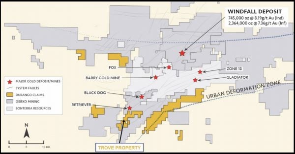
  • Drilling is underway on its wholly owned East Barry property at Windfall Lake, Québec.

Durango Resources Inc.(TSXV:DGO) (Frankfurt-86A1) (OTC:ATOXF), (the “Company” or “Durango”) is pleased to announce that further to the news release of January 8, 2021, drilling is underway on its wholly owned East Barry property at Windfall Lake, Québec.

The purpose of the East Barry Property drilling is to test high priority exploration targets coincident with elevated till anomalies of up to 2.19 g/t gold and pristine gold grains in till trend.  The drilling commenced on schedule on the East Barry Property and has reached approximately 300m depth on the first hole so far.

Marcy Kiesman, CEO of Durango, stated, “The drill team from Faubert & Fils Inc. are off to a great start on the East Barry Property and are drilling faster than scheduled. We are excited to finally be testing the large target anomaly on the East Barry Property and searching for the source of the gold grains in till to create value for Durango’s shareholders.”

Read More: https://agoracom.com/ir/Durango/forums/discussion/topics/752929-durango-begins-drilling-at-east-barry-windfall-lake/messages/2297591#message

VIDEO – American Creek $AMK.ca Investor Eric #Sprott Says “It certainly looks like they have 20 million ounces and they could easily get to 30 or 40 or 50 million ounces (of gold)” $TUD.ca $SII.ca $GTT.ca $AFF.ca $SEA.ca $SA $PVG.ca $AOT.ca $ESK.ca

Posted by AGORACOM-JC at 8:27 PM on Sunday, January 10th, 2021
American Creek Provides Update on Its First Quarter Filings

There is a lot we could say about American Creek Resources (AMK:TSXV) Treaty Creek Project but you might accuse of us of making it up, so we’ll let the words of 4 much smarter and wealthier people do all the talking:

Eric Sprott, Billionaire Investor and 2X Investor In American Creek Resources

“It certainly looks like they have 20 million ounces and they could easily get to 30 or 40 or 50 million ounces (of gold)” – July 24, 2020

Darren Blaney, President & CEO American Creek Resources

“Clearly, we have a massive, world-class gold system that still shows no signs of weakening to the northeast nor at depth.”

Walter Storm, CEO Tudor Gold (JV Partner) And Financier Of Osisko Gold Reaching $4.5 Billion Market Cap

“These results have proven that we have an excellent understanding of the structure, geology and mineralogy of this massive gold system.”

Ken Konkin , Tudor Gold Exploration Manager (Credited With Discovering Brucejack Mine Just South Of Treaty Creek) 

“Given the success of the two deep drill holes GS19-47 and GS19-48, the Goldstorm System shows no signs of weakening to the northeast and several more drill holes will be needed to find the length and depth of this huge gold system.

With a maiden resource estimate now expected over the next few months and the last set of drill results now announced, including 3.286 gpt AuEq over 82.5 Meters, Within 531.0 Meters of 0.999 gpt AuEq investors should grab their favourite beverage and watch this interview with American Creek Resources.

Durango $DGO.ca Drill on Site at East Barry, Windfall Lake $OSK.ca $BTR.ca $SII.ca $TLG.ca

Posted by AGORACOM at 9:59 AM on Friday, January 8th, 2021
  • Durango has received drill permits for the East Barry claim block to test high priority targets
  • Drilling is scheduled to begin on January 11th with two exploration holes on the East Barry Property budgeted for depths of approximately 750m each.

Durango Resources Inc.(TSXV-DGO) (Frankfurt-86A1) (OTC:ATOXF), (the “Company” or “Durango”) is pleased to announce that further to the news release of December 18, 2020, the drill and team from Faubert & Fils Inc. has arrived on site on its wholly owned East Barry property at Windfall Lake, Québec.

East Barry Property

Further to the news release of November 19, 2020, Durango has received drill permits for the East Barry claim block to test high priority targets coincident with high till anomalies of up to 2.19 g/t gold and pristine gold grains in till trend.  Now that weather conditions are favourable for access, a winter road has recently been built and a drill is on site at the East Barry Property. The drilling is scheduled to begin on January 11th with two exploration holes on the East Barry Property budgeted for depths of approximately 750m each.

Trove Property

To date, 2,100m has been drilled over nine holes on the Trove Property at an average depth of 233m.  Drilling on the Trove Property stopped before Christmas and Durango’s exploration crew has not been back to Windfall Lake yet in 2021 due to the Québec government Covid-19 restrictions. The Association de l’exploration Miniere du Québec (“AEMQ”) announced on January 6, 2021 that the government has made the decision to maintain mining activities, allowing exploration to continue in Québec.

Read More: https://agoracom.com/ir/Durango/forums/discussion/topics/752614-durango-drill-on-site-at-east-barry-windfall-lake/messages/2296658#message

American Creek’s JV Partner Tudor Gold Intersects 3.286 gpt AuEq over 82.5 Meters Within 531.0 Meters of 0.999 gpt AuEq at Treaty Creek $TUD.ca $SII.ca $GTT.ca $AFF.ca $SEA.ca $SA $PVG.ca $AOT.ca $ESK.ca

Posted by AGORACOM at 8:23 AM on Thursday, January 7th, 2021
American Creek Provides Update on Its First Quarter Filings
  • Best near-surface intercept was from the 300 Horizon in GS-20-91 on Section 112+50 NE that averaged 0.856 gpt AuEq over 1033.5 meters containing an enriched portion of 532.5 meters (60.0-592.5 m) that averaged 1.112 gpt AuEq.
  • GS-20-92 also had a remarkable 82.5 meter intercept (213.0-295.5 m) of 3.286 gpt AuEq within the 300 Horizon, which is the highest grade gold composite interval drilled to date on the project. This lies within a longer intercept of 531.0 meters (90.0-621.0 m) averaging 0.999 gpt AuEq.

Cardston, Alberta–(Newsfile Corp. – January 7, 2021) – American Creek Resources Ltd. (TSXV: AMK) (“the Corporation”) is very pleased to present results for the last set of 2020 diamond drill holes for the Goldstorm Zone at their JV flagship property, Treaty Creek. The project is located within the heart of the Golden Triangle of Northwestern British Columbia which is on-trend from Seabridge’s KSM Project located five kilometers southwest of the Goldstorm Zone. Results from sampling of 9,621.7 meters of HQ and NQ2 core, from 11 diamond drill holes, have recently been received from MSA Labs. American Creek’s JV partner, Tudor Gold has completed 50 diamond drill holes at the Goldstorm System (GS) and three diamond drill holes at the Perfect Storm Zone (PSZ), for respective totals of approximately 44,000 meters (GS) and 1,600 meters (PSZ) during the 2020 exploration season. It was necessary to abandon two of the final drill holes as ground conditions prevented the safe completion of GS-20-99 and GS-20-101 late in the season, however, significant gold and silver mineralization was encountered in GS-20-99 (0.647 gpt AuEq over 109.5 meters) and this hole ended in strong stockwork within the DS5 System. Unfortunately drill hole GS-20-101 was abandoned before intersecting the area of the intended target and this hole will be re-drilled in 2021. From the remaining 51 drill holes, all but one were successful in intersecting the intended targets.

Tudor Gold’s Vice President of Project Development, Ken Konkin, P.Geo., stated: “We are very pleased with the results obtained from our 2020 exploration program and we anticipate the completion of an initial resource estimate over the next few months. We are also determined to continue the exploration efforts in 2021 to better define and potentially expand the Goldstorm and Perfect Storm Systems. It was not possible to attempt drilling at some of our high priority exploration targets due to the rapid accumulation of snow in late November and December that caused avalanche hazards, therefore, these sites remain as excellent drill targets. We have since received our explosives permit and have purchased an explosives magazine so our avalanche teams can now safely remove snow build-up for the up-coming exploration season. Our goal is to again have a late spring start-up so that we can effectively prepare the slopes to allow drilling in the northeast area of the Goldstorm System that was not completed in 2020. The Au-Ag-Cu mineralization remains open to the northeast and to the southeast, with the possible exception of section 114+00 NE, where the easternmost drill hole (GS-20-102) may have defined the southeast limit in that area.”

Goldstorm Highlights include:

  • Eleven diamond drill holes in this news release totaling 9,621.7 meters; the favorable composite results are listed in Table 1 below.
  • Best near-surface intercept was from the 300 Horizon in GS-20-91 on Section 112+50 NE that averaged 0.856 gpt AuEq over 1033.5 meters (60.0-1093.5 m) containing an enriched portion of 532.5 meters (60.0-592.5 m) that averaged 1.112 gpt AuEq.
  • GS-20-92 also had a remarkable 82.5 meter intercept (213.0-295.5 m) of 3.286 gpt AuEq within the 300 Horizon, which is the highest grade gold composite interval drilled to date on the project. This lies within a longer intercept of 531.0 meters (90.0-621.0 m) averaging 0.999 gpt AuEq.
  • An aggressive 150 meter step-out drill hole (GS-20-99) extended the DS-5 Zone further to southeast on section 115+50 NE. The intercept averaged 0.647 gpt AuEq over 109.5 meters (855.5-965.0 m). The hole was lost at 965.0 meters in strong stockwork and DS5-type mineralization. The system remains open to the northeast and southeast along Section 115+50 NE.

Read More: https://agoracom.com/ir/AmericanCreek/forums/discussion/topics/752523-american-creek-s-jv-partner-tudor-gold-intersects-3-286-gpt-aueq-over-82-5-meters-within-531-0-meters-of-0-999-gpt-aueq-at-treaty-creek/messages/2296444#message

Loncor $LN.ca Continues to Intersect Significant Gold Mineralization at its Adumbi Flagship Deposit $RSG $NGT.to $GOLD $NEM $TECK.ca

Posted by AGORACOM at 11:14 AM on Tuesday, January 5th, 2021
This image has an empty alt attribute; its file name is Loncor-Small-Square.png
  • Drill results include 28.00 metres grading 3.26 g/t and 20.30 metres at 2.83 g/t Au

Loncor Resources Inc. (“Loncor” or the “Company“) (TSX: “LN”; OTCQX: “LONCF”; FSE: “LO51”) is pleased to announce that the third core hole of a 7,000 metre drilling program at its Adumbi deposit has intersected significant gold intersections of 28.00 metres grading 3.26 g/t gold (including 4.90 metres grading 6.96 g/t Au and 3.53 metres grading 8.30 g/t Au) and 20.30 metres grading 2.83 g/t Au (including 6.55 metres grading 4.64 g/t Au and 2.30 metres grading 7.25 g/t Au) at its 84.68% owned Imbo Project in the eastern part of the Ngayu greenstone belt in the Democratic Republic of the Congo (see Figure 1 below).

Mineralized sections are summarised in the table below:

Borehole
Number
From (m)To (m)Intersected
Width (m)
Grade (g/t) Au
LADD004429.00457.0028.003.26
LADD004Incl. 432.00436.904.906.96
LADD004Incl. 450.62454.153.538.30
LADD004473.80478.404.602.07
LADD004505.85526.1520.302.83
LADD004Incl. 506.85513.406.554.64
LADD004Incl. 523.85526.152.307.25

Borehole LADD004 had an inclination of minus 70 degrees and azimuth of 220 degrees at the start of hole and regular measurements of inclination and azimuth were taken at 30 metre intervals down the hole. All core was orientated and it is estimated that the true widths of the mineralised sections are 81% of the intersected width. All intercepted grades are uncut. LADD004 intersected the mineralized zone at a shallower depth than planned due to upward deflection of the borehole.

Commenting on these latest drilling results, Loncor President Peter Cowley said: “We are very encouraged by the results of the first three core holes of our 7,000 metre drilling program at Adumbi. All these boreholes have intersected significant widths and grades and should increase the current inferred mineral resource of 2.19 million ounces (28.97 million tonnes grading 2.35 g/t gold) at Adumbi, both within the current open pit and at depth below the pit (see Figure 2 below).

The gold mineralization at Adumbi is associated with a thick package (up to 130 metres) of interbedded banded ironstone and quartz carbonate and chlorite schist with higher grade sections being found in a strongly altered siliceous unit termed “Replaced Rock” (RP) where structural deformation and alteration has completely destroyed the primary host lithological fabric. Disseminated sulphide assemblages include pyrite, pyrrhotite and arsenopyrite which can attain up to 20% of the total rock in places.

The objective of the current drilling program at Adumbi is to outline additional mineral resources to the current inferred mineral resource of 2.5 million ounces of gold on Loncor’s 84.68%-owned Imbo Project which contains the Adumbi, Kitenge and Manzako deposits (inferred mineral resources of 30.65 million tonnes grading 2.54 g/t Au).

Quality Control and Quality Assurance
Drill cores for assaying were taken at a maximum of one-metre intervals and were cut with a diamond saw, with one-half of the core placed in sealed bags by Company geologists and sent to the Company’s on-site sample preparation facility. The core samples were then crushed down to 80% passing minus 2 mm and split with one half of the sample up to 1.5 kg pulverized down to 90% passing 75 microns. Approximately 150 grams of the pulverized sample was then sent to the SGS Laboratory in Mwanza, Tanzania (independent of the Company). Gold analyses were carried out on 50g aliquots by fire assay. In addition, check assays were also carried out by the screen fire assay method to verify high-grade sample assays obtained initially by fire assay. As part of the Company’s QA/QC procedures, internationally recognized standards, blanks and duplicates were inserted into the sample batches prior to submitting to SGS Laboratory.

Qualified Person
Peter N. Cowley, who is President of Loncor and a “qualified person” as such term is defined in National Instrument 43-101, has reviewed and approved the technical information in this press release.

Figures accompanying this announcement are available at

https://www.globenewswire.com/NewsRoom/AttachmentNg/dfb0c899-1320-4033-ae51-d9388d7ec1df
https://www.globenewswire.com/NewsRoom/AttachmentNg/6726c38b-eea9-4bfa-90a4-5f99e83c580d

Technical Reports
Additional information with respect to the Company’s Imbo Project (which includes the Adumbi deposit) is contained in the technical report of Minecon Resources and Services Limited dated April 17, 2020 and entitled “Independent National Instrument 43-101 Technical Report on the Imbo Project, Ituri Province, Democratic Republic of the Congo”. A copy of the said report can be obtained from SEDAR at www.sedar.com and EDGAR at www.sec.gov.

Additional information with respect to the Company’s Makapela Project, and certain other properties of the Company in the Ngayu gold belt, is contained in the technical report of Venmyn Rand (Pty) Ltd dated May 29, 2012 and entitled “Updated National Instrument 43-101 Independent Technical Report on the Ngayu Gold Project, Orientale Province, Democratic Republic of the Congo”. A copy of the said report can be obtained from SEDAR at www.sedar.com and EDGAR at www.sec.gov.

About Loncor Resources Inc.
Loncor is a Canadian gold exploration company focussed on the Ngayu Greenstone Belt in the northeast of the Democratic Republic of the Congo (the “DRC”). The Loncor team has over two decades of experience of operating in the DRC. Ngayu has numerous positive indicators based on the geology, artisanal activity, encouraging drill results and an existing gold resource base. The area is 220 kilometres southwest of the Kibali gold mine, which is operated by Barrick Gold (TSX: “ABX”; NYSE: “GOLD”). In 2019, Kibali produced record gold production of 814,000 ounces at “all-in sustaining costs” of US$693/oz. Barrick has highlighted the Ngayu Greenstone Belt as an area of particular exploration interest and is moving towards earning 65% of any discovery in approximately 2,000 km2 of Loncor ground in the Ngayu Greenstone Belt that they are exploring. As per the joint venture agreements entered between Loncor and Barrick, Barrick manages and funds exploration on the said ground until the completion of a pre-feasibility study on any gold discovery meeting the investment criteria of Barrick. In a recent announcement Barrick highlighted six prospective drill targets and have commenced confirmation drilling in 2020. Subject to the DRC’s free carried interest requirements, Barrick would earn 65% of any discovery with Loncor holding the balance of 35%. Loncor will be required, from that point forward, to fund its pro-rata share in respect of the discovery in order to maintain its 35% interest or be diluted.

In addition to the Barrick joint ventures, certain parcels of land within the Ngayu Belt surrounding and including the Adumbi and Makapela deposits have been retained by Loncor and do not form part of any of the joint ventures with Barrick. Barrick has certain pre-emptive rights over the Makapela deposit. Adumbi and two neighbouring deposits hold an inferred mineral resource of 2.5 million ounces of gold (30.65 million tonnes grading 2.54 g/t Au), with 84.68% of this resource being attributable to Loncor via its 84.68% interest in the project. Loncor’s Makapela deposit (which is 100%-owned by Loncor) has an indicated mineral resource of 614,200 ounces of gold (2.20 million tonnes grading 8.66 g/t Au) and an inferred mineral resource of 549,600 ounces of gold (3.22 million tonnes grading 5.30 g/t Au).   

Resolute Mining Limited (ASX/LSE: “RSG”) owns 26% of the outstanding shares of Loncor and holds a pre-emptive right to maintain its pro rata equity ownership interest in Loncor following the completion by Loncor of any proposed equity offering.

Additional information with respect to Loncor and its projects can be found on Loncor’s website at www.loncor.com.

Loncor $LN.ca Reports Significant Gold Intercepts at its Flagship Adumbi Deposit $TECK.ca $RSG $NGT.to $GOLD $NEM

Posted by AGORACOM at 8:42 AM on Tuesday, December 22nd, 2020
This image has an empty alt attribute; its file name is Loncor-Small-Square.png
  • Drill results include 33.30 metres grading 3.25 g/t Au 
    and 10.45 metres at 3.88 g/t Au

Loncor Resources Inc. (“Loncor” or the “Company“) (TSX: “LN”; OTCQX: “LONCF”; FSE: “LO51”) is pleased to announce that the second core hole of a 7,000 metre drilling program at its Adumbi deposit has intersected significant gold intersections of 33.30 metres grading 3.25 g/t gold (including 5.70 metres grading 7.00 g/t Au and 9.07 metres grading 5.11 g/t Au) and 10.45 metres grading 3.88 g/t Au, at its 84.68% owned Imbo Project in the eastern part of the Ngayu greenstone belt in the Democratic Republic of the Congo (see Figure 1 below).

Mineralized sections are summarised in the table below:

Borehole NumberFrom (m)To (m)Intersected Width (m)Grade (g/t) Au
LADD003224.55235.0010.453.88
LADD003253.50286.8033.303.25
LADD003Incl. 253.50259.205.707.00
LADD003Incl. 277.73286.809.075.11

Borehole LADD003 had an inclination of minus 57 degrees and azimuth of 220 degrees at the start of hole and regular measurements of inclination and azimuth were taken at 30 metre intervals down the hole. All core was orientated and it is estimated that the true widths of the mineralised sections are 80% of the intersected width. All intercepted grades are uncut. Borehole LADD003 was drilled in place of LADD002 which was stopped after deviating from its intended target depth.

Commenting on these latest drilling results, Loncor President Peter Cowley said: “We are very encouraged by the results of the first two core holes of our 7,000 metre drilling program at Adumbi where we are targeting a significant increase of resources, both within and below the open pit shell. These two infill holes were drilled within the open pit shell where there is already an inferred resource of 2.19 million ounces (28.97 million tonnes grading 2.35 g/t gold). These results will further increase the inferred resource. Deeper drilling is now being focussed on the plunging/downdip mineralization below the pit shell.”

In addition to core holes LADD001 and LADD003, the deeper hole LADD004, which was targeting mineralization 140 metres below previous borehole SDD53 drilled in 2017 (borehole SDD53 intersected 23.5 metres grading 6.08 g/t Au), was completed and cores have been submitted for assay. Deeper hole LADD007 and shallower hole LADD006 are currently being drilled to intercept the downdip/down plunge mineralized zone below the open pit shell and at shallower depth towards the northwest at the base of the pit shell respectively (see Figure 2 below).

The gold mineralization at Adumbi is associated with a thick package (up to 130 metres) of interbedded banded ironstone and quartz carbonate and chlorite schist with higher grade sections being found in a strongly altered siliceous unit termed “Replaced Rock” (RP) where structural deformation and alteration has completely destroyed the primary host lithological fabric. Disseminated sulphide assemblages include pyrite, pyrrhotite and arsenopyrite which can attain up to 20% of the total rock in places.

The objective of the current drilling program at Adumbi is to outline additional mineral resources to the current inferred mineral resource of 2.5 million ounces of gold on Loncor’s 84.68%-owned Imbo Project which contains the Adumbi, Kitenge and Manzako deposits (inferred mineral resources of 30.65 million tonnes grading 2.54 g/t Au).

Quality Control and Quality Assurance
Drill cores for assaying were taken at a maximum of one-metre intervals and were cut with a diamond saw, with one-half of the core placed in sealed bags by Company geologists and sent to the Company’s on-site sample preparation facility. The core samples were then crushed down to 80% passing minus 2 mm and split with one half of the sample up to 1.5 kg pulverized down to 90% passing 75 microns. Approximately 150 grams of the pulverized sample was then sent to the SGS Laboratory in Mwanza, Tanzania (independent of the Company). Gold analyses were carried out on 50g aliquots by fire assay. In addition, check assays were also carried out by the screen fire assay method to verify high-grade sample assays obtained initially by fire assay. As part of the Company’s QA/QC procedures, internationally recognized standards, blanks and duplicates were inserted into the sample batches prior to submitting to SGS Laboratory.

Qualified Person
Peter N. Cowley, who is President of Loncor and a “qualified person” as such term is defined in National Instrument 43-101, has reviewed and approved the technical information in this press release. 

Photos accompanying this announcement is available at https://www.globenewswire.com/NewsRoom/AttachmentNg/35d0f855-a11c-4ff5-b34e-893fd39bd5d9

https://www.globenewswire.com/NewsRoom/AttachmentNg/6499afb4-db81-4045-9af9-85cdec7362c8

Technical Reports
Additional information with respect to the Company’s Imbo Project (which includes the Adumbi deposit) is contained in the technical report of Minecon Resources and Services Limited dated April 17, 2020 and entitled “Independent National Instrument 43-101 Technical Report on the Imbo Project, Ituri Province, Democratic Republic of the Congo”. A copy of the said report can be obtained from SEDAR at www.sedar.com and EDGAR at www.sec.gov.

Additional information with respect to the Company’s Makapela Project, and certain other properties of the Company in the Ngayu gold belt, is contained in the technical report of Venmyn Rand (Pty) Ltd dated May 29, 2012 and entitled “Updated National Instrument 43-101 Independent Technical Report on the Ngayu Gold Project, Orientale Province, Democratic Republic of the Congo”. A copy of the said report can be obtained from SEDAR at www.sedar.com and EDGAR at www.sec.gov.

About Loncor Resources Inc.
Loncor is a Canadian gold exploration company focussed on the Ngayu Greenstone Belt in the northeast of the Democratic Republic of the Congo (the “DRC”). The Loncor team has over two decades of experience of operating in the DRC. Ngayu has numerous positive indicators based on the geology, artisanal activity, encouraging drill results and an existing gold resource base. The area is 220 kilometres southwest of the Kibali gold mine, which is operated by Barrick Gold (TSX: “ABX”; NYSE: “GOLD”). In 2019, Kibali produced record gold production of 814,000 ounces at “all-in sustaining costs” of US$693/oz. Barrick has highlighted the Ngayu Greenstone Belt as an area of particular exploration interest and is moving towards earning 65% of any discovery in approximately 2,000 km2 of Loncor ground in the Ngayu Greenstone Belt that they are exploring. As per the joint venture agreements entered between Loncor and Barrick, Barrick manages and funds exploration on the said ground until the completion of a pre-feasibility study on any gold discovery meeting the investment criteria of Barrick. In a recent announcement Barrick highlighted six prospective drill targets and have commenced confirmation drilling in 2020. Subject to the DRC’s free carried interest requirements, Barrick would earn 65% of any discovery with Loncor holding the balance of 35%. Loncor will be required, from that point forward, to fund its pro-rata share in respect of the discovery in order to maintain its 35% interest or be diluted.

In addition to the Barrick joint ventures, certain parcels of land within the Ngayu Belt surrounding and including the Adumbi and Makapela deposits have been retained by Loncor and do not form part of any of the joint ventures with Barrick. Barrick has certain pre-emptive rights over the Makapela deposit. Adumbi and two neighbouring deposits hold an inferred mineral resource of 2.5 million ounces of gold (30.65 million tonnes grading 2.54 g/t Au), with 84.68% of this resource being attributable to Loncor via its 84.68% interest in the project. Loncor’s Makapela deposit (which is 100%-owned by Loncor) has an indicated mineral resource of 614,200 ounces of gold (2.20 million tonnes grading 8.66 g/t Au) and an inferred mineral resource of 549,600 ounces of gold (3.22 million tonnes grading 5.30 g/t Au).   

Resolute Mining Limited (ASX/LSE: “RSG”) owns 26% of the outstanding shares of Loncor and holds a pre-emptive right to maintain its pro rata equity ownership interest in Loncor following the completion by Loncor of any proposed equity offering.

Additional information with respect to Loncor and its projects can be found on Loncor’s website at www.loncor.com.

Durango $DGO.ca Engages Additional Drill Company for Windfall Lake $OSK.ca $BTR.ca $SII.ca $TLG.ca

Posted by AGORACOM at 9:30 AM on Friday, December 18th, 2020

Vancouver, BC – TheNewswire – December 18, 2020 – Durango Resources Inc. (TSXV:DGO) (Frankfurt-86A1) (OT C :ATOXF), (the “ Company ” or “ Durango ”) is pleased to announce it has engaged an additional drill company for its exploration program on its wholly owned properties at Windfall Lake, Québec .

East Barry Property

Further to the news release of November 19, 2020, Durango has received drill permits for the East Barry claim block to test high priority targets coincident with high till anomalies of up to 2.19 g/t gold and pristine gold grains in till trend.  Now that weather conditions are favourable for preparing access, a drill has been commissioned to test a geophysical anomaly which also coincides with an artificial intelligence (“ AI ”) target. The Company has hired Faubert & Fils from Val d’Or, Québec, to complete several initial exploration drill holes on its East Barry Property.

Trove Property

To date, 1,700m has been drilled in eight holes on the Trove Property at an average depth of 213m.  Drilling is still continuing at the Trove Property with the drilling crew working on hole #9. As noted previously, the objective of the drill campaign is to test IP anomalies derived from previous exploration work.

The main lithologies observed in the drill holes are represented by mafic to intermediate volcanics, metasediments and felsic intrusives crosscut by quartz feldspar porphyry (“ QFP ”) and felsic dikes containing disseminated to semi-massive sulphides. Molybdenite, chalcopyrite and silver indicator alterations were also observed. The lithological contacts are marked by chlorite-epidote-carbonate alterations containing centimetric to decimetric mineralized quartz veins. The labs continue to be delayed and backed up due to extremely high quantities of samples they are receiving from multiple exploration companies and a shortage of personnel.

Durango’s high priority targets remain undrilled due the land condition caused by unseasonably warm weather, which has prevented the freezing required for access to the drill hole locations. Durango has 20 high priority holes planned for drilling on the Trove Property, between 200 and 800 meters deep, when the ground is sufficiently frozen to permit drill access.

Marcy Kiesman, CEO of Durango, stated, “The unseasonably warm weather has been challenging for our inaugural drill campaign on the Trove Property. We have completed initial drilling which will help our exploration team understand the local geology and structure in the area. As the weather in the area has recently become seasonably cold, we expect that our high priority targets will be drilled early in January. We are drilling in one of the best regions in Canada to find gold, we are fully financed and will continue to drill into 2021. We anticipate an exciting year ahead for Durango and our shareholders.”

The technical contents of this press release were approved by George Yordanov, professional geologist, an Independent Qualified Person as defined by National Instrument 43-101. The Trove Property has not yet been subject to an NI-43-101 report.

Trove Property, Québec

Durango owns 100% interest in the Trove claims, which are surrounded by Osisko Mining Inc. (TSX-OSK), in the Windfall Lake area between Val d’Or and Chibougamau, Québec. The 1,185 hectare property is compelling due to the coincidence of gold found in tills coinciding with magnetic highs, several Induced Polarization anomalies and two faults crosscutting the property.  The fault systems north and south of the Trove, control gold mineralization elsewhere, indicating the Trove has excellent exploration potential. Durango received all the final drill permits for the Trove property in September 2019 and is currently undertaking its inaugural drill program.

East Barry Property, Québec

Durango owns 100% interest in the East Barry claims which run parallel to Trove claims. The East Barry block is over 7,740 hectares in size and borders the eastern perimeter of Osisko’s holdings and the southern perimeter of Bonterra’s holdings and is less than 4km south of the Gladiator deposit. The East Barry claims host a gold trend which covers approximately 10km in length and is subparallel to the main Barry Fault held by Osisko Mining. In 2018, a till sampling program was conducted by Durango and one of the till samples returned forty-two (42) pristine gold grains with reported gold values of 2.184 g/t Au.  A high count of pristine gold grains indicates that the gold has travelled a very short distance from its source. The East Barry block underwent an Induced Polarization (“ IP ”) survey in 2018 which identified a high priority target coincident with the high count of pristine gold grains.

About Durango

Durango is a natural resources company engaged in the acquisition and exploration of mineral properties. The Company is positioned for discovery with a 100% interest in a strategically located group of properties in the Windfall Lake gold camp in the Abitibi region of Québec , Canada.

For further information on Durango, please refer to its SEDAR profile at www.sedar.com .

Marcy Kiesman, CEO

Telephone: 604.428.2900 or 604.339.2243

Email: [email protected]

Website: www.durangoresourcesinc.com

American Creek’s $AMK.ca JV Partner Tudor Gold Intersects 1.215 gpt AuEq over 354.0 Meters Within 1225.5 Meters of 0.702 gpt AuEq (Hole GS-20-94) $TUD.ca $SII.ca $GTT.ca $AFF.ca $SEA.ca $SA $PVG.ca $AOT.ca $ESK.ca

Posted by AGORACOM at 9:31 AM on Wednesday, December 16th, 2020
American Creek Provides Update on Its First Quarter Filings
  • 1.078 gpt AuEq over 345.0 Meters Within 921.0 Meters of 0.821 gpt AuEq (Hole GS-20-83) at the Goldstorm Zone, Treaty Creek, Located in B.C.’s Golden Triangle

Cardston, Alberta–(Newsfile Corp. – December 16, 2020) – American Creek Resources Ltd. (TSXV: AMK) (“the Corporation”) is pleased to present results for the fifth set of diamond drill holes for the Goldstorm Zone at their flagship property, Treaty Creek. The project is located in the heart of the Golden Triangle of northwestern British Columbia and is on-trend from Seabridge’s KSM Project located five kilometers southwest of the Goldstorm Zone. Results from 12 diamond drill holes have recently been received from MSA Labs with final results from another 11 diamond drill holes pending. All drill holes have successfully intersected the Goldstorm System, expanding and defining the mineralization along the northeast and southeast axes, as well as to depth. The Goldstorm System 300 Horizon has now been traced for 1100 meters along the northeast axis and, as well, the CS-600 and DS-5 zones have been expanded to the northeast and to depth. All 39 drill holes completed at Goldstorm during the 2020 program have encountered significant precious metal mineralization. The 2020 Treaty Creek Diamond Drill Program was completed last week, and field personnel have winterized the camp. The track-components of two track-mounted diamond drills remain on site ready for start-up of the 2021 exploration season.

Tudor Gold’s Vice President of Project Development, Ken Konkin, P.Geo., states: “We are very pleased with the results obtained from all 39 drill holes completed this year to-date and we anticipate the release of the final 11 holes of the year within a few weeks. This brings the total to 50 drill holes that were completed this year at the Goldstorm Zone. These latest holes continued to expand the limits of the mineralized targets along the northeastern and the southeastern axes, and to depth. For a fifth consecutive press release, we have surpassed our best result from last years’ drill hole program (0.697 AuEq over 1081.5 meters in hole GS-19-47) with drill holes GS-20-83 and GS-20-94 as described in the headline. The final 11 drill holes represent over 9600 meters of drilling and we expect that MSA Labs will complete the analysis of these final samples as soon as possible.”

Treaty Creek Highlights include:

  • Twelve drill holes presented in this press release total 11,551.1 meters.
  • The best results were from GS-20-94, a near-surface 354.0 meter intercept (36.0-390 m) averaging 1.215 gpt AuEq and GS-20-82 with a 351m intercept (113.0-464.0 m) averaging 1.051 gpt AuEq. Both holes are located on Section 111+00 NE.
  • Equally impressive was drill hole GS-20-83 that also had a near-surface intercept over a similar 345.0 meters (73.5-418.5 m) that averaged 1.078 gpt AuEq on Section 112+50 NE.
  • More Core Drilling did an excellent job completing 50 HQ/NQ2 diamond drill holes totaling 43,972 meters at Goldstorm and 1,636 meters at the Perfect Storm Target with three drill holes.

The following three tables below provide the complete list of composited drill hole results as well as the drill hole data including hole location, elevation, depth, dip and azimuth.

Table l: Results Goldstorm Zone Press Release December 15th 2020

SectionHoleZoneFromToInterval (m)AuAgCuAuEQ
114+00 NEGS-20-80300H + CS600222.501349.001126.500.3691.666530.486
  including 300H398.00695.50297.500.4881.981350.531
  and including CS600831.501028.00196.500.5723.2527031.011
115+50 NEGS-20-81300H + CS600 + DS5558.401389.50831.100.4221.569400.580
  including 300H + CS600558.40957.50399.100.5291.9617120.807
  with 300H558.40636.5078.101.0471.521391.086
  and with CS600704.00957.50253.500.4812.3724940.879
111+00 NEGS-20-82300H + CS600113.001041.50928.500.6292.465190.736
  including 300H113.00464.00351.000.9693.562631.051
  with 300H224.00422.00198.001.2835.294081.407
112+50 NEGS-20-83300H + CS600 + DS573.50994.50921.000.6763.976550.821
  including 300H73.50418.50345.001.0083.481911.078
  and including CS600566.45727.50161.050.4263.9028630.898
  and including DS5813.00994.50181.500.9197.331901.035
112+50 NEGS-20-85300H66.50692.00625.500.7483.802750.834
  CS600752.00989.00237.000.2412.2317340.524
  DS51118.001278.50160.500.5112.111280.555
114+00 NEGS-20-86300H118.50577.50459.000.7123.432630.792
  CS600730.50942.00211.500.4692.4921720.821
  DS51014.001425.00411.000.5952.851450.650
  including1192.501395.00202.500.8893.391300.949
111+00 NEGS-20-89*300H87.00125.0038.001.14212.85911.309
111+00 NEGS-20-90300H + CS60063.00847.50784.500.6462.894650.750
  including 300H72.00405.00333.000.9153.601770.984
  and including CS600643.50768.00124.500.6354.6016320.932
110+00 NEGS-20-93*300H20.50237.50217.000.5353.401520.599
  incl.20.50131.00110.500.8505.492060.946
111+00 NEGS-20-94300H36.001261.501225.500.6462.501780.702
  including36.00390.00354.001.1234.142871.215
  or including36.00820.50784.500.8563.452390.933
108+00 NEGS-20-96300H6.00109.50103.500.8042.271290.850
  CS600279.00385.50106.500.2283.7712350.457
110+00 NEGS-20-97300H18.40584.00565.600.6091.951070.648
  incl.18.40381.50363.100.6932.351410.742

*lost drill hole in mineralization

  • All assay values are uncut, and intervals reflect drilled intercept lengths.
  • HQ and NQ2 diameter core samples were sawn in half and typically sampled at standard 1.5m intervals.
  • The following metal prices were used to calculate the Au Eq metal content: Gold $1322/oz, Ag: $15.91/oz, Cu: $2.86/lb. Calculations used the formula Au Eq g/t = (Au g/t) + (Ag g/t x 0.012) + (Cu% x 1.4835). All metals are reported in USD and calculations do not consider metal recoveries. True widths have not been determined as the mineralized body remains open in all directions. Further drilling is required to determine the mineralized body orientation and true widths.

Table ll: Drill Data for Holes in Press Release December 15th, 2020


Table II and Table III

To view an enhanced version of Table II and Table III, please visit:
https://orders.newsfilecorp.com/files/682/70402_5f70404f040adb98_002full.jpg

Attached are Sections 108+00 NE, 110+00 NE, 111+00 NE, 112+50 NE, 114+00 NE and 115+50 NE showing holes traces with histogram plots for gold and copper results and a Plan Map showing the drill hole and section locations.

Walter Storm, President and CEO, stated: “We are very pleased to announce the safe successful completion of our 2020 diamond drill hole program. We completed over four times the amount of drilling from the previous year’s program, greatly advancing Tudor’s flagship Treaty Creek Property. We completed almost 44,000 meters of drilling at the Goldstorm System and over 1,600 meters of drilling at the Perfect Storm target. Once we receive the final results from the last eleven drill holes, we will then pass the data to our resource engineers and geoscientists for an initial resource estimate. Continued drilling is required for 2021 to locate the limits or edges of the mineralized system. Due to the size and robust nature of the mineralization, the Goldstorm System remains open on all fronts and to depth. We are proud of what we have achieved in these last two years of exploration and in-particular, the great effort to withstand the harsh winter elements during November and December at Treaty Creek to bring the 2020 drill campaign to a safe close. Our commitment is to continue to advance the project as quickly as possible. We have left the track-drill carriage components for two track-mounted drill rigs on-site so our team can get an early start to the 2021 drill season. We look forward to receiving the final results of the eleven drill holes from MSA Labs within a couple of weeks to complete the 2020 exploration season on schedule.”

Tudor Gold Corp and our associated service companies have taken extreme measures to maintain the highest professional standards while working within COVID-19 health and safety protocols.

Darren Blaney, CEO of American Creek, commented: “We are extremely impressed with the drill program our JV partner Tudor Gold has completed this year and with the significant potential deposit that it has revealed. The Goldstorm zone already appears to be world-scale in size and yet is still open from the northeast to the southeast and remarkably, also at depth. The Magnetotelluric survey done in 2016, which shows potential continuation of gold mineralization well beyond the extent of this year’s drilling of Goldstorm, has proven to be very accurate. That same survey data also shows tremendous potential at the Perfect Storm zone which, due to permitting restraints, was only able to have the outer halo drill tested this year, and yet the drilling still encountered gold mineralization.

“Recognition must be given to both Tudor Gold and More Core for initiating the drill program in early May and carrying through to December. This is no small feat in the Golden Triangle region. While bad weather and Covid-19 limited many projects within the area this season, Tudor and More Core delivered an incredible 45 km of drilling with every hole encountering significant gold mineralization.

“We look forward to the remaining holes, the metallurgical work, and ultimately the maiden resource calculation of the Goldstorm on Treaty Creek sometime in the new year.”

QA/QC

Drill core samples were prepared at MSA Labs’ Preparation Laboratory in Terrace, BC and assayed at MSA Labs’ Geochemical Laboratory in Langley, BC. Analytical accuracy and precision are monitored by the submission of blanks, certified standards and duplicate samples inserted at regular intervals into the sample stream by Tudor Gold personnel. MSA Laboratories quality system complies with the requirements for the Company. International Standards ISO 17025 and ISO 9001. MSA Labs is independent of the company.

Qualified Person

The Qualified Person for Tudor’s news release for the purposes of National Instrument 43-101 is Tudor’s Vice President of Project Development, Ken Konkin, P.Geo. He has read and approved the scientific and technical information that forms the basis for their disclosure contained in their news release.

The Qualified Person for this news release is James A. McCrea, P. Geo., for the purposes of National Instrument 43-101. While American Creek has not independently confirmed Tudor’s information, Mr. McCrea has read and approved the scientific and technical information that forms the basis for the disclosure contained in this news release.

Treaty Creek JV Partnership

The Treaty Creek Project is a Joint Venture with Tudor Gold owning 3/5th and acting as operator. American Creek and Teuton Resources each have a 1/5th interest in the project creating a 3:1 ownership relationship between Tudor Gold and American Creek. American Creek and Teuton are both fully carried until such time as a Production Notice is issued, at which time they are required to contribute their respective 20% share of development costs. Until such time, Tudor is required to fund all exploration and development costs while both American Creek and Teuton have “free rides”.

Treaty Creek Background

The Treaty Creek Project lies in the same hydrothermal system as Pretium’s Brucejack mine and Seabridge’s KSM deposits however, with far better logistics.

For a better understanding of the mineralized zones at the Goldstorm, please view this video (which shows the original 20,000m planned drill program opposed to the 40,000m+ drill program that has taken place).


Sulphurets Hydrothermal System

To view an enhanced version of this map, please visit:
https://orders.newsfilecorp.com/files/682/70402_5f70404f040adb98_003full.jpg

About American Creek

American Creek is a Canadian junior mineral exploration company with a strong portfolio of gold and silver properties in British Columbia.

Three of those properties are located in the prolific “Golden Triangle”; the Treaty Creek JV with Tudor Gold/Walter Storm, the D-1 McBride, and the 100% owned past producing Dunwell Mine.

The Corporation also holds the Gold Hill, Austruck-Bonanza, Ample Goldmax, Silver Side, and Glitter King properties located in other prospective areas of the province.

See additional images of drill locations in this press release at www.americancreek.com.

For further information please contact Kelvin Burton at: Phone: 403 752-4040 or Email: [email protected]. Information relating to the Corporation is available on its website at www.americancreek.com.

Neither the TSX Venture Exchange nor its Regulation Services Provider (as that term is defined in the policies of the TSX Venture Exchange) accepts responsibility for the adequacy or accuracy of this release.

This news release contains forward-looking statements. These statements are based on current expectations and assumptions that are subject to risks and uncertainties. Readers should not place undue importance on forward-looking information and should not rely upon this information as of any other date. Actual results could differ materially because of factors discussed in the Corporation’s management discussion and analysis filed with applicable Canadian securities regulators, which can be found under the Corporation’s profile on www.sedar.com. The Corporation does not assume any obligation to update any forward-looking statements.


Goldstorm Zone Plan View

To view an enhanced version of this map, please visit:
https://orders.newsfilecorp.com/files/682/70402_5f70404f040adb98_004full.jpg


Section 108+00 NE

To view an enhanced version of this map, please visit:
https://orders.newsfilecorp.com/files/682/70402_5f70404f040adb98_005full.jpg


Section 110+00 NE

To view an enhanced version of this map, please visit:
https://orders.newsfilecorp.com/files/682/70402_5f70404f040adb98_006full.jpg


Section 111+00 NE

To view an enhanced version of this map, please visit:
https://orders.newsfilecorp.com/files/682/70402_5f70404f040adb98_007full.jpg


Section 112+50 NE

To view an enhanced version of this map, please visit:
https://orders.newsfilecorp.com/files/682/70402_5f70404f040adb98_008full.jpg


Section 114+00 NE

To view an enhanced version of this map, please visit:
https://orders.newsfilecorp.com/files/682/70402_5f70404f040adb98_009full.jpg


Section 115+50 NE

To view an enhanced version of this map, please visit:
https://orders.newsfilecorp.com/files/682/70402_5f70404f040adb98_010full.jpg

AGORACOM Small Cap 60: Affinity Metals $AFF.ca Starts Drilling Carscallen Extension Adjoining Melkior/Kirkland Lake Gold JV $OSK.ca $RKR.ca $MKR.ca $SII.ca $KL.ca

Posted by AGORACOM at 1:47 PM on Friday, December 11th, 2020
https://s3.amazonaws.com/s3.agoracom.com/public/companies/logos/564657/hub/Affinity_Metals_Corp_Logo.png

Affinity Metals discusses rational for recently acquired Carscallen Extension property. The Carscallen Extension immediately adjoins the Melkior/Kirkland Lake Gold JV Carscallen Project located approximately 6 km west of Pan American Silver’s West Timmins Mine and approximately 25 KM West of Timmins. The company has recently announced the commencement of drilling on trend with the projected extension of the Shenkman-ZamZam gold system which has been the focus of the Melkior/Kirkland Lake Gold JV.

American Creek: A Positive Impact For The Sulphurets Hydrothermal System $AMK.ca $TUD.ca $SII.ca $GTT.ca $AFF.ca $SEA.ca $SA $PVG.ca $AOT.ca $ESK.ca

Posted by AGORACOM at 11:58 AM on Monday, December 7th, 2020

On Friday December 4th, Seabridge Gold (SEA) announced its intentions to purchase the Snowfield deposit from Pretium Resources (PVG), details here.  As a result, we experienced a high volume of emails and calls as to how this may affect Treaty Creek.  In our opinion, we think it’s a positive move for all three projects located in the Sulphurets Hydrothermal System. Our analysis of the transaction and the associated benefits is as follows:
 
Below is an image created by Seabridge showing the KSM and Snowfield deposits and the relative gold grades/value of those deposits.  Technically, the Snowfield is the top part of the Mitchell deposit, which it sits beside. 

On its own, the Snowfield added no present value to Pretium in the near term for a few reasons: The Snowfield has a very low-grade halo that on its own, at present gold values, isn’t profitable to produce.  It has a higher-grade core but that core isn’t large enough to justify the costs to get it out at today’s gold price. Logistics.  Because the Snowfield is located upslope above the Mitchell deposit in the Mitchell valley, mine construction would have been very difficult due to the terrain combined with the proximity to the Mitchell deposit located below owned by Seabridge. Access.  Even if the gold grades were higher and there was room to develop the Snowfield on its own, there appears to be no feasible way to get the ore to market except through the proposed Mitchell Teigen Tunnels (MTT) which (if built) would be owned by Seabridge.  The above, and perhaps some other reasons as well, is why the Snowfield deposit has been sitting there with no progression for many years, which in its present state added zero value to Pretium.  It could be argued that a sale worth $3 USD per ounce in the ground is a lot better than $0 per ounce while it sits dormant.  We think this was a great deal for PVG as they get: $100m up front in working capital $20m down the road A Net Smelter Royalty (NSR) of 1.5% down the road

By combining the Snowfield with the KSM, SEA removed the “higher grade core isn’t big enough on its own” problem, the “no room” problem, and the “access” problem.  We think this was a great deal for SEA as it helps them accomplish their goals:

  1. Improve their ounces/share ratio
  2. Improve the NPV and IRR on the KSM
  3. Allow them to defer underground operations until later in the production schedule
  4. Pay down the Cap-X for the KSM quicker

 
We think this a great deal for Treaty Creek (TC) shareholders (TUD, AMK, TUO) because anything that improves Seabridge’s chances of going into production is potentially beneficial to us:

  1. The only route for the KSM to go into production is through the use of the MTT which closely follows both the Kyba Line and the Sulphurets Thrust Fault through most of TC (this is the most heavily mineralized trend though TC including the Perfect Storm (PSZ), the Goldstorm (GS), and orpiment (GS2) zones as seen on the image above.
    1. If SEA is able to find a route through TC without disturbing potential deposits then it will build important infrastructure (bridge, roads, power, etc.) right onto TC.
    2. If SEA isn’t able to find a route through TC without disturbing potential deposits then SEA potentially will form an agreement with TC owners (benefiting TC shareholders) followed by building important infrastructure right onto TC.
  2. A second mine, especially one of this magnitude, going into production within the Sulphurets Hydrothermal System will undoubtedly capture the attention of investors and mining companies and shine a spotlight on the third project advancing in the same system; Treaty Creek.

 
The $3 USD per ounce paid for the Snowfield was a good deal for both companies and has no real bearing on potential insitu gold deposits and associated valuations at TC.  It’s all a question of grade, logistics, and potential buyers.  The Snowfield has low grade, horrible logistics (to be developed on its own) and potential for only one buyer (SEA).  TC sits “on the right side of the mountain” only 20km away down a valley from the highway and the cheapest power in the world.  The Goldstorm zone also has its highest gold grades right at surface (300 zone) over a very extended area opposed to dipping steeply into the ground. The logistics, and therefor potential Cap-X and Op-X, are completely different at TC vs both the Snowfield and the KSM.

In conclusion, we believe that the Snowfield purchase by Seabridge will positively impact every company located within the Sulphurets Hydrothermal System. We view this as another very positive development in the rapid progression of Treaty Creek’s development. 

-Kelvin Burton