- Grab samples from RVX property return assay values of up to 12.60 g/t Pd + Pt
- rab samples from footwall to Dana South return assay values of up to 4.36 g/t Pd + Pt
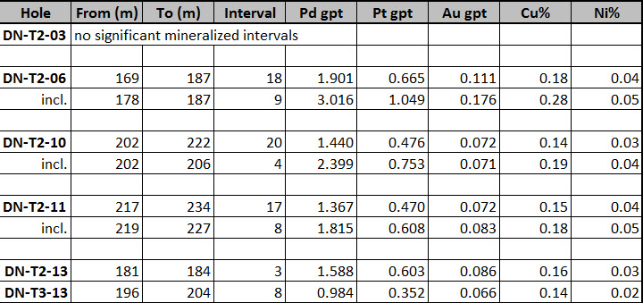
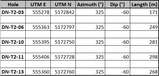
- Drill program on 2015 discovery at T2 near Dana North completed
- 2.5 Moz Platinum Metals in near-surface Measured and Indicated Resources
- Within 100 road-km of Sudbury and strong infrastructure and community support
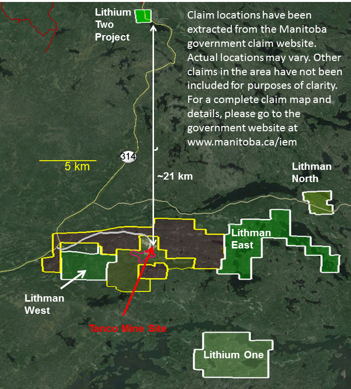
- 100%-owned Lithium Division with exploration projects in Manitoba and Nevada
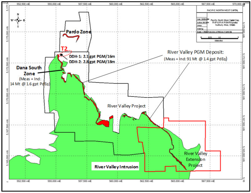
December 6, 2016 /Â TheNewswire /Â Vancouver, British Columbia -Â Pacific North West Capital Corp. (“PFN”)Â (TSXV: PFN OTCQB: PAWEF FSE: P7J)Â is pleased to announce results from the first phase of the 2016 field exploration program on its new 100% held RVX property and its flagship RVP property near Sudbury, Ontario. The program, consisting of geological mapping and mineral prospecting, confirmed the presence of high-grade platinum metal mineralization on the RVX property and expanded the overall footprint of mineralization at the Dana South Zone (Figure 1).
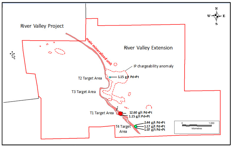
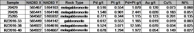
Three of 4 targeted areas on the RVX property were mapped and sampled by PFN geologists (Figure 2). A grab sample from Target Area 1 returned assay values of 12.60 g/t Pd + Pt from a rusty sulphide zone that extends across the width of the outcrop exposure. Three surface grab samples from Target Area 4 returned Pd + Pt assay values of greater than 1 g/t, with a maximum of 2.44 g/t Pd+ Pt, 0.2% Cu and 0.05% Ni from mineralized outcrops of melagabbronorite with pegmatitic clinopyroxenite fragments and quartz veins. A grab sample from Target Area 2 returned a Pd + Pt assay value of 1.11 g/t. Target Area 3 was not sampled due to limited access. Clearly follow-up field work is warranted in each of these four target areas. Moreover, the IP chargeability anomalies in the footwall rocks and to the west internally within the River Valley Intrusion (near the boundary with the RVP) remain to be explored (Figure 2).
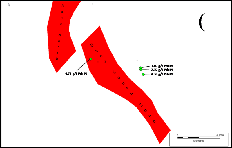
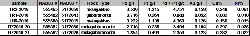
On the RVP property (Figure 1), three grab samples from the footwall to Dana South Zone returned assays of greater than 2 g/t Pd + Pt and 0.15% Cu (Table 2). These three samples were taken from outcrops of River Valley Intrusion along the shore of Dana Lake, approximately 50 metres from the east boundary of the Dana South Zone (Figure 3). The area between the outcrop and stripped area is covered, but the indications of high-grade mineralization where sampled suggest that the Dana South Zone could potentially be expanded eastward, or that another mineralized zone may be present. Further field work in this area is definitely warranted. The broader implication of these findings, particularly in view of the T2 discovery near Dana North in 2015, is that the footwall to the main River Valley Intrusion remains under explored for PGM and will be a high priority for future exploration programs.
Note too that a major objective of the field exploration program was to search for outcrops of River Valley Intrusion rocks in the footwall above the T2 target (Figure 1). Outcrops of favourable intrusive rocks (Breccia Unit and Boundary Zone) were found, but do not appear to be mineralized. Nevertheless, the presence of such rocks where they are not supposed to be supports the geological model for the T2 Target. A follow-up drill program on the T2 Target was completed in October and assay results are pending from the laboratory.
Financial support for the 2016 field program from the JEAP Program is gratefully acknowledged.
Click Image To View Full Size
Figure 1. Geological map showing the locations of the River Valley Extension Project and the River Valley Project properties.
Click Image To View Full Size
Figure 2. Geological outline map showing the locations of high grade assay samples taken from the River Valley Extension Project.
Table 1. Selected samples collected from target areas of PFN’s River Valley Extension Project
Click Image To View Full Size
Click Image To View Full Size
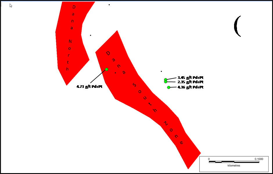
Figure 3. Geological map showing the location of three high grade PGM samples to the east (footwall) of the Dana South Zone, River Valley deposit. These samples are from mineralized outcrops of favourable River Valley rocks along the shore of Dana Lake (not shown). Note that the PGM grades of these samples (2.35 to 4.36 g/t Pd + Pt) are similar to the PGM grade (4.73 g/t Pd + Pt) of a sample taken from the Dana South Zone itself.
Table 2. Selected samples collected from the Dana South Zone area of PFN’s Flagship River Valley Project
Click Image To View Full Size
Sample Assay Procedures
The grab samples were sent to the SGS Canada Inc. Laboratory in Lakefield, Ontario sample preparation and assay analyses. The preparation involved crushing of 3 kilograms of each sample to 90% passing 2 mm, and then pulverizing 0.5 kilograms to 85% passing 75 micrometres. Palladium, platinum and gold were assayed by fire assay with ICP-AES finish. Copper, nickel and 32 other metals were assayed by two acid digestion and ICP-OES finish. Blind standards and blanks were not submitted for assay with the samples, due to the reconnaissance nature of the field program. However, the SGS Canada Inc. Laboratory followed their own internal QA/QC procedures for the assay analyses.
About PFN’s Lithium Division
The Company’s Lithium Division will focus on the Discovery, Acquisition, Exploration and Development of Lithium Projects in Canada. In the United States, the Company will use its wholly owned U.S.A subsidiary to Acquire and Develop Projects, in Active Mining Camps, in Nevada, Arizona and California.
Management believes that these New Age Metals, Lithium, PGMs and Rare Earths, have robust macro trends with surging demands and limited supply. Going forward, this New Division will Explore for the Minerals needed to fuel the demand for Energy Storage and other Core 21st Century Technologies.
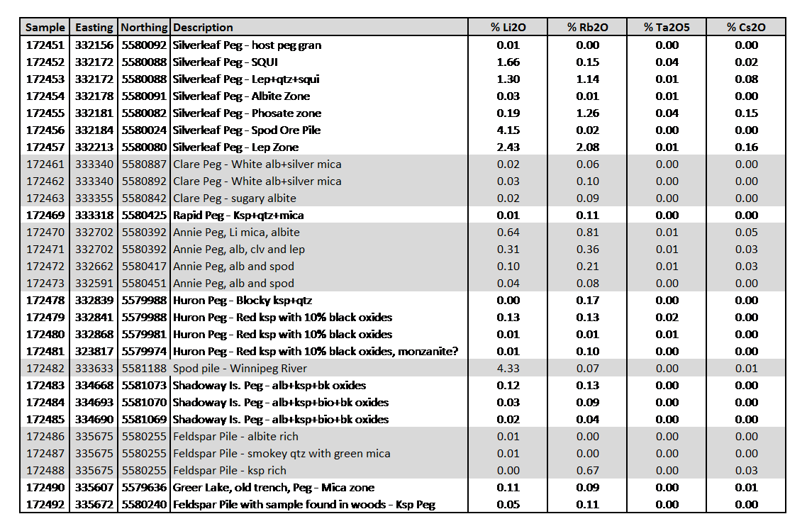
The Company has a Growing Portfolio of Lithium Projects: The Clayton Valley Forks Li Project, in Nevada, is a recent Lithium Brine Project acquired by the Company (see PFN News Releases). The Company also has several Hard Rock Lithium Projects in Canada: To date the Company has Acquired 5 Hard Rock Lithium Projects, in the Winnipeg River Pegmatite Field, in SE Manitoba (see PFN News Releases). This Pegmatite Field hosts the giant Tanco Pegmatite that has been mined for Tantalum, Cesium and Spodumene (one of the primary Lithium ore minerals) in varying capacities, since 1969. Today, the Tanco Mine is focused on the Mining and Production of Cesium Formate, a drilling fluid for the petroleum industry. PFN’s Li Projects are strategically situated to further Explore this Pegmatite Field. Presently, the Company is the Largest Claim Holder in the Winnipeg River Pegmatite Field.
Lithium and Platinum Group Metal Prices have improved drastically in recent months. Lithium supplies remain in deficit, relative to their demand. Both Metals Groups are used for the expanding worldwide automobile industry (conventional and electric). In the case of PGMs, demand is increasing for Autocatalysts, a key component for reducing toxic emissions, for automotive, gasoline and diesel engines. Regarding Lithium, there is an ever-increasing demand for batteries in cellphones, laptops, electric cars, solar storage, wireless charging and renewable energy products.

Click Image To View Full Size
PFN’s 5 New Lithium Projects in Manitoba, Surrounding Tanco Mine
Click Image To View Full Size
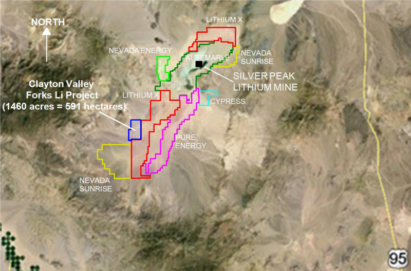
Company claim blocks in the Clayton Valley area of Nevada
(Above map is a Company-made composite and not intended for redistribution.
The Company accepts no responsibility for the accuracy of these claim blocks, other than the claim block associated with the Clayton Valley Forks Li Project)
Clayton Valley is located in Esmeralda County, Nevada, host to the Albemarle Corporation’s Silver Peak Lithium Mine and Brine processing operations. The mine has been in operation since 1967 and remains the only Brine based Lithium Producer in North America. The new project acquisition in Nevada provides the Company a project, in an area that is well known for its Lithium Carbonate production. Clayton Valley is a centralized location in Nevada, with highway access, power infrastructure, water and local labour.
The company’s new Lithium Brine Project will be approximately 3.5 hours away from Tesla’s Gigafactory, which has a planned annual Lithium-ion battery production capacity of 35 gigawatt-hours per year, by 2020. The CV West Li project is located approximately 3 hours north of the Faraday Electric Car Factory to be operated in Las Vegas, Nevada.
Clayton Valley is one of the few locations globally known to contain commercial-grade Lithium-Enriched Brines.
QUALIFIED PERSON
The contents contained herein that relates to Exploration Results or Mineral Resources is based on information compiled, reviewed or prepared by Dr. Bill Stone, Principal Consulting Geoscientist for Pacific Northwest Capital. Dr. Stone is the Qualified Person as defined by National Instrument 43-101 and has reviewed and approved the technical content.
On behalf of the Board of Directors
“Harry Barr”
Harry G. Barr
Chairman and CEO
Neither the TSX Venture Exchange nor its Regulation Services Provider (as that term is defined in the policies of the TSX Venture Exchange) accepts responsibility for the adequacy or accuracy of this release.
Cautionary Note Regarding Forward Looking Statements: This release contains forward-looking statements that involve risks and uncertainties. These statements may differ materially from actual future events or results and are based on current expectations or beliefs. For this purpose, statements of historical fact may be deemed to be forward-looking statements. In addition, forward-looking statements include statements in which the Company uses words such as “continue”, “efforts”, “expect”, “believe”, “anticipate”, “confident”, “intend”, “strategy”, “plan”, “will”, “estimate”, “project”, “goal”, “target”, “prospects”, “optimistic” or similar expressions. These statements by their nature involve risks and uncertainties, and actual results may differ materially depending on a variety of important factors, including, among others, the Company’s ability and continuation of efforts to timely and completely make available adequate current public information, additional or different regulatory and legal requirements and restrictions that may be imposed, and other factors as may be discussed in the documents filed by the Company on SEDAR (www.sedar.com), including the most recent reports that identify important risk factors that could cause actual results to differ from those contained in the forward-looking statements. The Company does not undertake any obligation to review or confirm analysts’ expectations or estimates or to release publicly any revisions to any forward-looking statements to reflect events or circumstances after the date hereof or to reflect the occurrence of unanticipated events. Investors should not place undue reliance on forward-looking statements.