Agoracom Blog Home

Posts Tagged ‘#mining’

INTERVIEW: PFN (PFN:TSXV) At the Forefront of PGM and Lithium Exploration $PFN.ca

Posted by AGORACOM-JC at 9:01 AM on Tuesday, October 11th, 2016

River Valley is Canada’s Largest Undeveloped Primary PGM Deposit.

  • 2.5 Moz PGM, in Measured plus Indicated Mineral Resources
  • PFN currently has 100% ownership in the River Valley Project, subject to a 3% NSR, with Options to Buy Down
  • Includes more than 600 holes drilled, since year 2000, and several Mineral Resource Estimates and Metallurgical Studies
  • Drill Program confirms New High Grade T2 Discovery
  • Ongoing Strategic Partner Search for River Valley Project

Results for the current Mineral Resource Estimate are summarized below:

  • High Confidence: Measured plus Indicated = 72% of total
  • Reported on PdEq basis: Pd=40% & Pt=20% of the Payable Metals
  • Pd to Pt ratio = 2.5:1; Cu to Ni ratio = 3:1
  • High Grade Potential: particularly in the north part of the River Valley Deposit
  • Resources under Evaluation for Development Potential as Open Pit Mining Operation

The Company’s Lithium Division will focus on the Discovery, Acquisition, Exploration and Development of Lithium Projects in Canada. In the United States, the Company will use its wholly owned U.S.A subsidiary to Acquire and Develop Projects, in Active Mining Camps, in Nevada, Arizona and California.

PFN’s 5 New Lithium Projects in Manitoba, Surrounding Tanco Mine

Hub On AGORACOM / Corporate Profile / Watch Interview

WEEKEND FEATURE: PFN (PFN:TSXV) At the Forefront of PGM and Lithium Exploration $PFN.ca

Posted by AGORACOM-JC at 12:13 PM on Friday, October 7th, 2016

River Valley is Canada’s Largest Undeveloped Primary PGM Deposit.

  • 2.5 Moz PGM, in Measured plus Indicated Mineral Resources
  • PFN currently has 100% ownership in the River Valley Project, subject to a 3% NSR, with Options to Buy Down
  • More than 600 holes drilled, since year 2000, and several Mineral Resource Estimates and Metallurgical Studies
  • Drill Program confirms New High Grade T2 Discovery
  • Ongoing Strategic Partner Search for River Valley Project

Results for the current Mineral Resource Estimate are summarized below:

  • High Confidence: Measured plus Indicated = 72% of total
  • Reported on PdEq basis: Pd=40% & Pt=20% of the Payable Metals
  • Pd to Pt ratio = 2.5:1; Cu to Ni ratio = 3:1
  • High Grade Potential: particularly in the north part of the River Valley Deposit
  • Resources under Evaluation for Development Potential as Open Pit Mining Operation

The Company’s Lithium Division will focus on the Discovery, Acquisition, Exploration and Development of Lithium Projects in Canada. In the United States, the Company will use its wholly owned U.S.A subsidiary to Acquire and Develop Projects, in Active Mining Camps, in Nevada, Arizona and California.


PFN’s 5 New Lithium Projects in Manitoba, Surrounding Tanco Mine


Hub On AGORACOM / Corporate Profile / Watch Interview

Finore Mining to Acquire 100% interest in Panther Creek Cobalt Property, Idaho, Changes Name to Hybrid Minerals Corp. $FIN.ca

Posted by AGORACOM-JC at 10:44 PM on Thursday, October 6th, 2016

Fm_copy

  • Signed a Definitive Agreement with Utah Mineral Resources LLC to acquire 100% interest on the Panther Creek Cobalt property, East-Central Idaho
  • Located in the heart of the Idaho cobalt belt, home to the Salmon Canyon and Iron Creek Deposits
  • Road accessible
  • Consists of 50 lode mining claims with a total area of 1000 acres located in Lemhi County

Vancouver, B.C. / October 6, 2016 – FINORE MINING INC. (CSE: FIN; OTCQX: FNREF) (the “Company” or “Finore”) -announces that the Company signed a Definitive Agreement with Utah Mineral Resources LLC (“UMR”) to acquire 100% interest on the Panther Creek Cobalt (“Co”) property, East-Central Idaho.

The Panther Creek Cobalt Property (“the Property”) is located in the heart of the Idaho cobalt belt which is home to the Salmon Canyon and Iron Creek Deposits. The property is road accessible and located 26 miles west of the Salmon, East-Central Idaho. The property consists of 50 lode mining claims with a total area of 1000 acres located in Lemhi County.

The Property is well located within the vicinity of the Blackbird copper-cobalt Mine in the famous Blackbird District. The copper-cobalt mineralization is hosted in the micaceous quartzites of the Apple Creek Formation of the well-known Idaho Cobalt Belt. A historic mine adit on the property was channel sampled by US Geological Survey and returned 1.04% cobalt and 4.14% copper across 10 feet or 3.04 metres (Re: US Geol. Surv. Open File Report 98-478). Extensive exploration consisting of detailed geological mapping emphasizing stratigraphy and structure, systematic geochemical soil sampling and trenching is required to confirm the historical result as this does not conform to the NI 43-101 rules and regulations.

Idaho cobalt belt

The Idaho cobalt belt trends northwest-southeast for nearly 60 km in east-central Idaho (Fig. 1). Included within this belt are numerous historic mines and prospects of the centrally located Blackbird district, the Salmon Canyon deposit at the northwest end, and deposits of the Iron Creek area at the southeast end (U.S. Geological Survey, 2010). The Idaho cobalt belt is important nationally because it contains the largest known cobalt resources in the United States (Slack et al., 2012). Ecobalt Solutions Inc. is developing the Idaho Cobalt Project, located in the Blackbird district. Ecobalt completed a Preliminary Economic Assessment with a measured and indicated resource of 3.48 million tonnes grading 0.55% Co and 0.85% Cu.

History and production

Production in the Blackbird district began in 1917 following initial discovery of the sulfide deposits in 1893. Minor Co was produced from 1917 to 1920 at the Haynes-Stellite Mine (Bennett, 1977). Major production began in 1949 and continued intermittently to 1960 at the Blackbird (Uncle Sam) underground mine and the Blacktail open pit, which together yielded ca. 5 Mt of ore averaging 1.5 wt % Cu and 0.6 wt % Co.

The location of the Idaho Cobalt Belt with the historic mines and occurrences is shown in the figures below. The Panther Creek prospect is located in the Blackbird district.


Click Image To View Full Size

Map of central Idaho showing location of mineral deposits (modified, Lund, et al, 2011. Econ Geol. v.106) Dot overlay shows location of Idaho cobalt belt. Index map is (upper right) shows location of Late Cretaceous Idaho batholith relative to area of this figure. Numbers refer to important named mines and prospects: 1 = Yellowjacket mine, 2 = Salmon Canyon copper mine, 3 = more than 40 deposits of the Blackbird district including the Panther Creek property, 4 = Musgrove prospect, 5 = Blackpine mine, 6 = Iron Creek prospect, 7 = Spring Creek deposits, 8 = Shoup area mines, 9 = Pine Creek mines, 10 = Diamond Creek mines, 11 = Copper King mine, 12 = Pope Shenon mine, 13 = Woods Creek deposit, 14 = McConn Creek deposit, 15 = Ulysses mine, 16 = Lemhi Pass thorite mines and prospects, 17 = Copper Queen Mine


Click Image To View Full Size


Click Image To View Full Size

FIG. 2. Generalized geologic map of the Blackbird district showing strata-bound and discordant mineral deposits ((Slack, 2012. Econ.Geol. v.107).

Why Cobalt?

The Board of Directors are looking forward to be exploring for Cobalt in the well-known Idaho Cobalt Belt. Cobalt is considered to be a metal of the future with growing demand in technology, health and energy industries. The main components of electric vehicle motors and many rechargeable Lithium-ion batteries, contain as much as 60% cobalt. A sustained cobalt price growth could occur over the next few years as battery demand grows, driven by electric car battery market expansion in line with demand for low emission vehicles

Consideration for the Property:

To acquire 100% of the Panther Creek Cobalt Property, the Company will:

Fund and incur Exploration Expenditures of $375,000 over an Earn-In-Period of three (3.) years from the date of signature of the Option Agreement.

-on or before the first anniversary of the Execution Date: $ 75,000 (seventy five thousand dollars)

-on or before the second anniversary of the Execution Date: $ 100,000 (one hundred thousand Dollars.

-on or before the third anniversary of the Execution Date: $ 200,000 (one hundred thousand Dollars).

In addition to incurring the above Exploration Expenditures, Finore will pay UMR each of the following option premium amounts during the Earn-In Period in cash or shares in the Company

.

-on the Execution Date: $ 25,000 within 14 days of Exchange Acceptance and issue to UMR a total of 3,500,000 common shares of Finore at a deemed value of $0.05 per share;

-on or before the first anniversary of the Execution Date: the sum of $ 150,000 or the equal value in common shares of Finore; and

-on or before the second anniversary of the Execution Date: the sum of $ 150,000 the equal value in common shares of Finore.

-In the event that proven and probable mineral resources for the purposes of NI 43-101, of at least of 4 million tonnes grading a minimum 0.25% Co is determined on the Property by Finore or before the 5 year anniversary of the Effective Date, Finore shall issue to UMR an additional 2,000,000 common shares in the capital of Finore.

Name Change

The Company is planning to apply to regulatory authorities for a name change to Hybrid Minerals Corp.

Private Placement:

The Company also announces that it will conduct a non-brokered private placement of up to 20,000,000 units (the “Units”) at a price of $0.10 per Unit to raise total gross proceeds of up to $2,000,000. Each Unit will consist of one common share of the Company (a “Share”) and one half (1/2) transferable common share purchase warrant (a “Warrant”). Each whole Warrant will be exercisable to acquire one additional Share for a period of two (2) years from the closing of the Private Placement at an exercise price of $0.25 per share. In the event that the common shares of the Company trade at a closing price in excess of $0.20 per share for a period of 10 consecutive trading days at any time after four months past the closing date, the Company will accelerate the expiry date of the Warrants by giving notice to the holders thereof and in such case, the warrants will expire on the 30th day after the date on which such notice is given by the Company.

The net proceeds from the Offering will be used for the option payments and first year work program on the Panther Creek Property, general working capital, clearing outstanding payables and for evaluating other green metal properties.

The non-brokered private placement is subject to the completion and execution of appropriate documentation, acceptance for filing by the Canadian Securities Exchange and receipt of any required regulatory approvals.

Mohan R. Vulimiri, M.Sc., P.Geo, Director of Finore, is a Qualified Person as defined by NI 43-101. Mr. Vulimiri has approved the corporate and technical content contained in this press release

On behalf of the board of directors of Finore Mining Inc.,

“Peter Tegart”

Peter Tegart

President & CEO

The CSE does not accept responsibility for the adequacy or accuracy of this release.

The forward-looking information contained in this press release is made as of the date of this press release and, except as required by applicable law, the Company does not undertake any obligation to update publicly or to revise any of the included forward-looking information, whether as a result of new information, future events or otherwise, except as may be required by law. By its very nature, such forward-looking information requires the Company to make assumptions that may not materialize or that may not be accurate. This forward-looking information is subject to known and unknown risks and uncertainties and other factors, which may cause actual results, levels of activity and achievements to differ materially from those expressed or implied by such information.

FEATURE: Explor Resources (EXS: TSX-V) 609K oz Indicated / 470K oz Inferred Gold $EXS.ca

Posted by AGORACOM-JC at 9:50 AM on Thursday, October 6th, 2016

Why Explor Resources?

  • Flagship Property Offers The Following:
  • NI 43-101 Resource – 609,000 oz Indicated / 470,000 Inferred
  • Teck Resources To Spend $12 MILLION To Earn 70%
  • Property Is 13 KM From Downtown Timmins
  • 2nd Project 43-101 Open Pit Resource
  • 1.4 MILLION T Indicated @ 1.38% Copper
  • 2.09 MILLION T Inferred @ 1.26% Copper

ONTARIO AND NEW BRUNSWICK PROPERTIES CURRENTLY UNDER EXPLORATION

Timmins Porcupine West (TPW) (4300 ha)

  • NI 43-101 Resource: 609,000 oz Indicated
    470,000 oz Inferred Gold
  • 13 km from downtown Timmins
  • Property is 2.5 km, NE of LSG West Timmins Mine
  • Model: Hollinger McIntyre Gold System: 30,000,000 oz. Au
  • Discovery Hole 10-30 : 9.22g/tonne over 11.0 meters
  • Optioned to Teck Resources
  • Teck to spend $12,000,000 to earn 70% interest

Chester Copper & VMS Project (3500ha)

  • Mineral Target: Cu, Pb, Zn, Ag, & Au
  • 70 km SW of Bathurst NB
  • Structural Model Complete
  • 300 m wide x 2000m long mineralized Corridor identified
  • Ramp to ore zone (480 meter long (3m x 4m)
  • Optioned to Brunswick Resources (BRU)
  • Brunswick to spend $500,000 over 3 years
  • Explore to receive $40,000 and 5,000,000 shares of BRU
  • Open pit resource – NI 43-101 Resource: 1,400,000 Indicated t @ 1.38% Cu
    2,089,000 Inferred t @ 1.26 % Cu


Kidd Creek Project (2466 ha)

  • Mineral Target: Cu-Zn Ore
  • Located 1.0 km west of Kidd Creek Mine
  • Kidd Mine yielded 130M tonnes of Cu-Zn Ore since 1960
  • Numerous Geophysical max/min and IP Targets
  • Diamond Drilling winter 2015/2016

QUEBEC PROPERTIES CURRENTLY UNDER EXPLORATION

East Bay (3203 ha):

  • Mineral Target: Gold
  • Lies on Porcupine Destor Fault Zone, on strike with Beattie & Donchester mine
  • Historical channel samples by Lacana Mining in 1982 including: 0.81 oz/ton over 5ft; 0.16 oz/ton over 6 ft; 0.10 oz/ton over 10 ft
  • Wrap around Clifton Star

Nelligan (1198 ha):

  • Mineral Target: Nickel
  • Located in Val d’Or mining district of Quebec
  • Historical grab samples of 10% Ni and 0.6% Cu obtained by INCO
  • Discovered anomalous Nickel, Copper Zones

Launay (2250 ha):

  • Mineral Target: Nickel
  • Mineralized zones contained in mafic volcanic rocks
  • Contiguous to Royal Nickel’s Dumont property (NW end)

12 Month Stock Chart

FEATURE:Treaty Creek Included In Seabridge Gold Plan To Take KSM Into Production $AMK.ca

Posted by AGORACOM-JC at 2:11 PM on Wednesday, October 5th, 2016

AMK: TSX-V, OTCBB: ACKRF

WHY AMERICAN CREEK RESOURCES?

  • American Creek has exceptional precious metal properties throughout British Columbia including two of the most prospective projects found in B.C.’s Golden Triangle; the Electrum and Treaty Creek properties.
  • The Electrum property is geologically similar to the nearby Brucejack (going into production in 2017) and the nearby Premier Mine (past producer).
  • So far over 130 million ounces of gold, 800 million ounces of silver and 20 billion pounds of copper (all categories included), representing one of the greatest concentrations of metal value on the planet, have been delineated within the geological system shared by KSM, Brucejack, and Treaty Creek.

RECENT HIGHLIGHTS

  • A JV agreement with Tudor Gold was just signed to develop the Electrum and Treaty Creek projects.The people behind Tudor Gold were also behind Osisko Gold, one of Canada’s biggest mining successes.They have the resources, expertise, and experience of taking projects into production.
  • Specimens from the Electrum property average 27,092 gm/tonne silver and 248 gm/tonne gold. Read More
  • Tudor has now completed the previously announced Magnetotelluric survey and has commenced drilling Read More

EXCEPTIONAL PROPERTIES

The Electrum is located in British Columbia’s prolific Golden Triangle; one of the richest areas of mineralization in the world with one new mine having come online in 2015 (Imperial Mines Red Chris) and another scheduled for 2017 (Pretium Brucejack) and at least three more world-class mining projects headed toward production.

The property has a rich history with some of the highest grade hand-mined ore mined in North America (1,661 g/t Au with 2,596 Ag)combined with excellent logistics. The property is located directly between two high-grade veining gold/silver mines; the past producing Silbak Premier mine and Pretiums high-grade Brucejack mine (production in 2017). All three lie within the Iskut mineral district (a particularly prolific part of the Canadian Cordillera) with numerous geological similarities between them.

On May 11th 2016 American Creek formed a joint venture agreement with Tudor Gold wherein American Creek retains 40% of the property.Tudor Gold will be the operator while both companies will work together to develop the property.This partnership is very beneficial for American Creek as its flagship project will be able to advance at a much greater pace due to the geological expertise, experience, resources, management, and exposure that Tudor Gold brings to the table.

The Electrum Property holds significant potential which led to a JV agreement with Tudor Goldwhen considering its high-grade nature combined with the exceptional logistics in place.

  • Located in the prolific Golden Triangle of northwestern British Columbia, an area encompassing mineral rich belts that host more than 43 past producing mines including Eskay Creek, Silbak Premier, Granduc and Big Missouri. It is a hotbed of activity with one new mine having come online in 2015 (Imperial Mines Red Chris) and another scheduled for 2017 (Pretium Brucejack) and at least three more world-class mining projects headed toward production.
  • Located in a particularly rich valley with 4 past producing commercial mines and a 5th in the adjacent valley.
  • Includes the historic East Gold Mine that had intermittent small-scale production of approximately 46 tonnes of ore with grades averaging 1,661 grams of gold per tonne and 2,596 grams of silver per tonne (roughly 50oz gold with 75oz silver).
  • Mineralization is believed to be very similar to the silver-gold-base metal veins responsible for the precious metal mineralization found in the Silbak Premier Mine and the Big Missouri mines (located in same extended valley).
  • Pretiums Brucejack Summary Report (for exploration) compares itself geologically to the Silbak Premier mine.
  • Electrums Summary Report (for exploration) compares itself geologically to the Silbak Premier mine.
  • High-grade mineralization at surface has been confirmed extending over a 500 x 500m area. Specimens across that area include numerous bonanza grade results including 1,926 g/t gold with 37,995 g/t silver, 80.96 g/t gold with 80,818 g/t silver, 694 g/t gold with 550 g/t silver, 54.77 g/t gold with 14,903 g/t silver, 615 g/t gold with 616 g/t silver, 395 g/t gold with 46,601 g/t silver, and many more.
  • Drilling showed a continuation of high grade intervals at depth including grades up to 440 g/t gold with 400 g/t silver over 0.52m. Other high grade gold intervals include 38.4 g/t over 0.45m, 31.4 g/t over 2m, 29.9 g/t over 2m,16.9 g/t over 1.5m, 16.7 g/t over 1.3m, and 12.3 g/t over 1.9m along with longer intervals of 3 g/t over 26m, 1 g/t over 50m, and 0.5 g/t over 31m. High grade silver intervals at depth including 583g/t over 0.3m, 420 g/t over 0.9m, 384 g/t over 0.7m and 374 g/t over 0.65m were also discovered.
  • A very successful small program was run in the fall of 2015 wherein:
    o A new approach focusing on high-grade was employed
    o New zones of gold / silver mineralization were discovered with drill intersections grading from one up to 14 grams of gold per tonne.
    o A better understanding of the high-grade veining system was obtained
    o Numerous outcrops were tested on surface. 24 specimens were taken from the Shiny Cliff and averaged 248 g/t gold with 27,092 g/t silver, the highest sample being 1,926 g/t gold with 37,955 g/t silver. Specimens taken from a boulder 20m down slope from the Shiny Cliff averaged 10 g/t gold with 857 g/t silver.
    o Eleven specimens were collected along a quartz vein at the Rico showing. The specimens from the structure averaged 54 g/t gold with 11,512 g/t silver, the highest sample being 270 g/t gold with 44,048 g/t silver. Thirteen specimens were collected from a vein on Mine Hill and averaged 6 g/t gold with 522 g/t silver.
    o The program proved the Electrum Property has multiple high-grade gold-silver epithermal breccia vein systems and gave us a better understating of their sequencing.
  • Excellent logistics including road access, power located 2 km away and bulk tonnage shipping ports and supportive mining town located just40 km away in a mining friendly jurisdiction.

For a short video on the Electrum property; click here.

For a presentation on the 2015 drill program; click here.

Treaty Creek Property

Treaty Creek is located in British Columbia’s prolific Golden Triangle; one of the richest areas of mineralization in the world with one new mine having come online in 2015 (Imperial Mines Red Chris) and another scheduled for 2017 (Pretium Brucejack) and at least three more world-class mining projects headed toward production.

On May 11th 2016 American Creek formed a joint venture agreement with Tudor Gold wherein American Creek retains a carried interest of 20% of the property until a production notice is given. A partner with the expertise, backing, management team, and experience to develop this potential world scale project was sought after by AMK. Tudor Gold meets and exceeds all of those requirements needed to fully realize the potential of Treaty Creek. American Creek will not have to raise money or dilute as development takes place.

Mineralization in the Treaty Creek claims area lies within the same broad hydrothermal system that generated the several deposits on the Seabridge Gold KSM and the Pretivm Brucejack properties that lie immediately southwest of the Treaty Creek claims. So far over 130 million ounces of gold, 800 million ounces of silver and 20 billion pounds of copper (all categories included), representing one of the greatest concentrations of metal value on the planet, have been delineated within the geological system shared by KSM, Brucejack, and Treaty Creek.

Seabridge Gold’s KSM is the world’s largest undeveloped gold/silver project by reserves while Pretium’s Brucejack is the highest grading undeveloped large-scale gold project in the world. KSM has just past the environmental and permitting stage while the Brucejack is in construction phase. Treaty Creek is part of the same large hydrothermal system as it’s neighbours, hosts the same bedrock geology as its neighbours, the same magneto-telluric (MT) anomalies that proved to be large deposits on both Seabridge and Pretivm’s claims, the same major fault system (Sulphurets) that is responsible for KSM’s deposits, and initial exploration and drilling show similar results to initial drilling on KSM.

A recent Government geological report shows Treaty to be “in the right neighbourhood for B.C’s next big deposit”.Treaty meets all three main criteria of the report which states “that is a big game changer for explorers in the region, because it will get them closer to making a discovery”.

The geological markers on Treaty Creek are saying there are great similarities to the KSM / Brucejack / Valley of the Kings and other deposits found within the same hydrothermal system.Now the right partnership is in place to advance the project and realize its potential.

For a 2 minute video on Treaty Creek; click here.

For an in-depth geological video on Treaty Creek; click here.

Gold Hill Property

The Gold Hill property is located in Southern British Columbia near Cranbrook.Logistics are exceptional with forestry roads throughout the property and power nearby. Gold on the Wild Horse River was discovered in the fall of 1863 by American prospectors and one of the West’s greatest gold rushes ensued. The Wild Horse River yielded close to $7,000,000 dollars (48 tonnes of gold or around $2 Billion in today’s dollars). It is believed that a far greater amount was mined and never accounted for.

The river is considered to be one of the greatest gold creeks in the entire province of British Columbia. The majority of the gold taken from the river was located along a 6km stretch between Boulder Creek (upstream) and Brewery Creek (downstream). While most of the gold has been taken from the placer deposits downstream from Gold Hill, there are still placer operations in the area ranging from small scale panning / sluicing to full scale mining operations.

Historic efforts were made to trace the source / sources of the placer gold. This led explorers (including geologists from Cominco) up the Boulder Creek to what is now called the Gold Hill property. This property constitutes a significant portion of the watershed for Boulder Creek including two main areas where gold was recovered by Cominco (along with others). These areas are known as Big Chief and Gold Hill. Both areas are believed to be major contributing sources for the incredible resources found in the Wild Horse River and as such have tremendous potential. While gold was discovered on the property, the gold price in 1900 did not support extensive hard rock exploration at the time.

The property has been overlook and sat dormant for many years. American Creek was very fortunate to acquire a property with such a rich history and such huge potential.

Pacific North West Capital Corp. Expands River Valley Extension Property, Near Sudbury, Ontario $PFN.ca

Posted by AGORACOM-JC at 9:38 AM on Wednesday, October 5th, 2016
Hublogo1_copy

  • PFN’s newly staked claims increases size of its River Valley Extension property to 2150 ha
  • Expands coverage of footwall and internal targets within the River Valley Intrusion

  • PFN’s property position at River Valley increased to a total of 76 km2 or 7600 ha

  • PFN’s River Valley Project consists of a Primary Platinum Metal Deposit

  • 2.5 Moz Platinum Metals in near-surface Measured and Indicated Resources

  • Within 100 road-km of Sudbury and strong infrastructure and community support

  • Summer-Fall Surface Exploration Programs underway

  • New 100%-owned Li Division with Pegmatite Projects in Manitoba and Brine Projects in Nevada – Summer/Fall surface programs underway

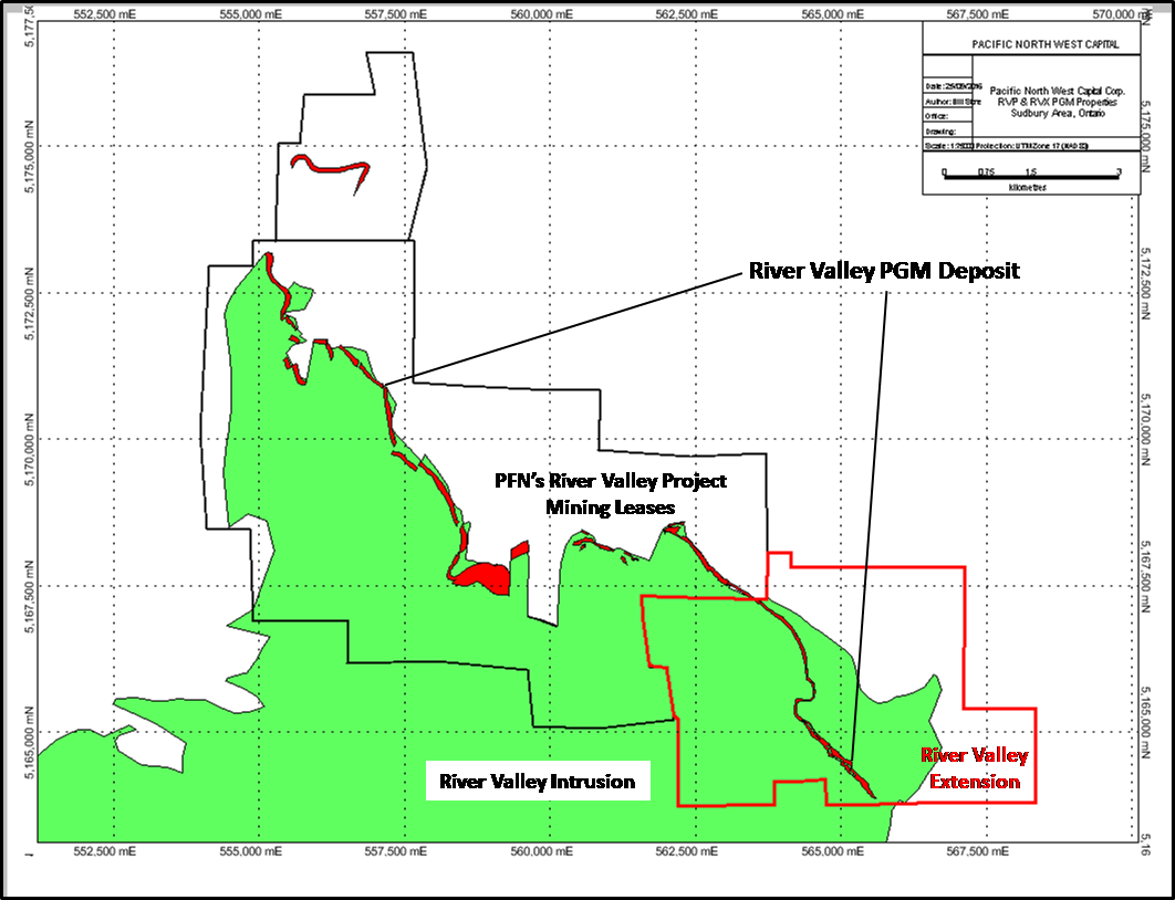
October 5, 2016 / Vancouver, British Columbia – Pacific North West Capital Corp. (“PFN” the “Company”) (TSXV: PFN OTCQB: PAWEF FSE: P7J) announces staking of 8 new unpatented mining claims adjacent to its recently acquired River Valley Extension property (“RVX” – see PFN press release dated August 4th, 2016), located next to the company’s 100% owned River Valley PGM deposit (Figure 1). The River Valley PGM deposit on RVX has been targeted in drill programs completed by the previous owner (Mustang Minerals Corp.) that returned high-grade PGM assays at shallow depths. Collectively, the 100%-owned acquired and newly staked claims of the RVX now comprise 2153 ha and are located within 100 road-kms of the City of Sudbury, Ontario.

The expanded RVX overlies the southeast extension of the River Valley PGM deposit, as indicated in drill results, mineralized outcrops and geophysical surveys, and the footwall rocks and interior units of the River Valley Intrusion. Recent drilling of the footwall rocks to PFN’s River Valley Project, located on the same mineralized trend to the NW, discovered high-grade and near surface PGM mineralization at T2 (see PFN press release dated March 11th, 2015). Geological and geophysical trends on the RVX suggest presence of similar footwall targets.

Internally, the River Valley Intrusion on the RVX remains vastly under-explored. Surface grab samples, geophysical surveys and sporadic drilling on the RVX have returned high-grade PGM assays. However, the focus of exploration has generally been along the basal margin of the River Valley Intrusion and, more recently, in the footwall rocks to the intrusion. Field exploration programs are currently underway on the RVX to develop targets for drill testing, in 2017. Approximately $140K in assessment credits can be applied to the claims within the RVX property, allowing PFN to focus exploration on the highest priority targets.


Click Image To View Full Size

Figure 1: Geological map showing the location of PFN’s 100% owned River Valley Extension PGM property over the southeast corner of the River Valley Intrusion, adjacent to the River Valley PGM Project.

About PFN’s Platinum Group Metals Division

River Valley is Canada’s Largest Undeveloped Primary PGM Deposit.

Achievements to date and Future Plans for River Valley are outlined below as follows:

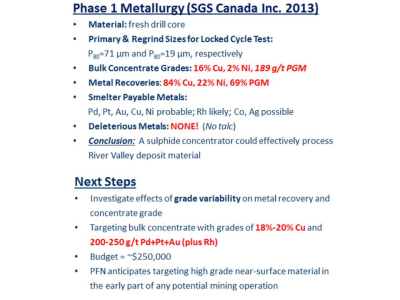
  1. 1.PFN currently has 100% ownership in the River Valley Project, subject to a 3% NSR, with Options to Buy Down
  2. 2.Completed Exploration and Development Programs, on the River Valley Property:

Include more than 600 holes drilled, since year 2000, and several Mineral Resource Estimates and Metallurgical Studies

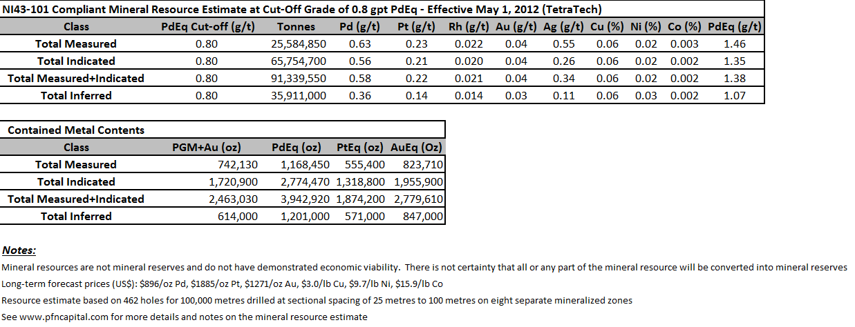
  1. 3.Results for the current (2012) Mineral Resource Estimate are below
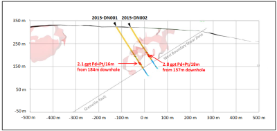
  2. 4.2015 Drill Program confirms New High Grade T2 Discovery
  3. 5.Exploration and Development Plans outlined for 2016
  4. 6.Ongoing Strategic Partner Search for River Valley Project
  5. 7.Results for the current Mineral Resource Estimate are summarized below:

– Prepared by Tetra Tech (Wardrop)

– High Confidence: Measured plus Indicated = 72% of total

– Reported on PdEq basis: Pd=40% & Pt=20% of the Payable Metals

– Pd to Pt ratio = 2.5:1; Cu to Ni ratio = 3:1

– High Grade Potential: particularly in the north part of the River Valley Deposit

– Resources under Evaluation for Development Potential as Open Pit Mining Operation


Click Image To View Full Size


Click Image To View Full Size

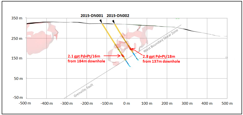
  1. 8.Results for the 2015 Discovery Drill Program on the T2 Target are as follows:
    • -Drill hole intercepts much higher than the average grade, of current Mineral Resource Estimate

      -Possible New Mineralized Zone at the north end of the River Valley Deposit

      -Show potential to take the River Valley PGM Project in a New Direction

      -More drilling planned


Click Image To View Full Size

  1. 9. Exploration and Development Plans for 2016
  • -Mineral Prospecting and Geological Mapping on surface: In Progress

    -Drill Programs targeted to add more, higher grade: Drilling Slated for Fall 2016

    -Geological Interpretation and 2D/3D Modelling of all Drill and Surface Results

    -Ongoing Strategic Partner Search for River Valley

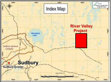
Map showing the location of River Valley PGM Project relative to the City of Sudbury.

About PFN’s Lithium Division

The Company’s Lithium Division will focus on the Discovery, Acquisition, Exploration and Development of Lithium Projects in Canada. In the United States, the Company will use its wholly owned U.S.A subsidiary to Acquire and Develop Projects, in Active Mining Camps, in Nevada, Arizona and California.

Management believes that these New Age Metals, Lithium, PGMs and Rare Earths, have robust macro trends with surging demands and limited supply. Going forward, this New Division will Explore for the Minerals needed to fuel the demand for Energy Storage and other Core 21st Century Technologies.

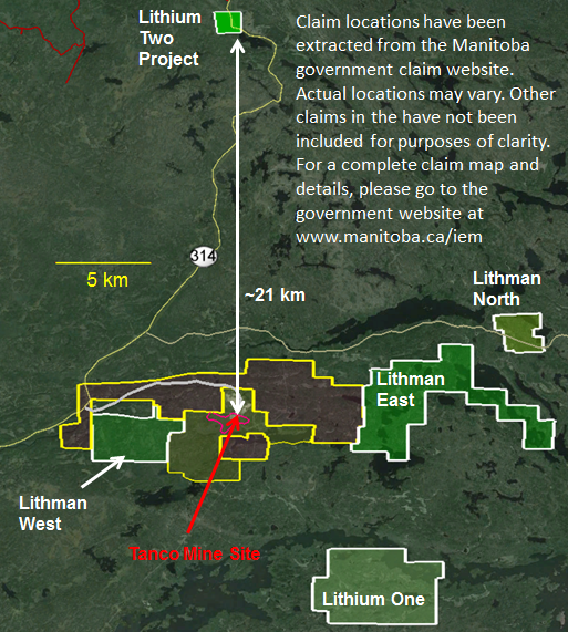
The Company has a Growing Portfolio of Lithium Projects: The Clayton Valley Forks Li Project, in Nevada, is a recent Lithium Brine Project acquired by the Company (see PFN News Releases: April 25th, 2016 and May 9th, 2016). The Company also has several Hard Rock Lithium Projects in Canada: To date the Company has Acquired 5 Hard Rock Lithium Projects, in the Winnipeg River Pegmatite Field, in SE Manitoba (see PFN News Releases: April 21st 2016, May24th, 2016, June 15th, 2016, July 5th, 2016 and July 21st, 2016). This Pegmatite Field hosts the giant Tanco Pegmatite that has been mined for Tantalum, Cesium and Spodumene (one of the primary Lithium ore minerals) in varying capacities, since 1969. Today, the Tanco Mine is focused on the Mining and Production of Cesium Formate, a drilling fluid for the petroleum industry. PFN’s Li Projects are strategically situated to further Explore this Pegmatite Field. Presently, the Company is the Largest Claim Holder in the Winnipeg River Pegmatite Field.

Lithium and Platinum Group Metal Prices have improved drastically in recent months. Lithium supplies remain in deficit, relative to their demand. Both Metals Groups are used for the expanding worldwide automobile industry (conventional and electric). In the case of PGMs, demand is increasing for Autocatalysts, a key component for reducing toxic emissions, for automotive, gasoline and diesel engines. Regarding Lithium, there is an ever increasing demand for batteries in cellphones, laptops, electric cars, solar storage, wireless charging and renewable energy products.


Click Image To View Full Size

PFN’s 5 New Lithium Projects in Manitoba, Surrounding Tanco Mine


Click Image To View Full Size

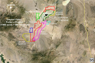
Figure 1: Company claim blocks in the Clayton Valley area of Nevada

(Figure 1 is a Company-made composite and not intended for redistribution.

The Company accepts no responsibility for the accuracy of these claim blocks, other than the claim block associated with the Clayton Valley Forks Li Project)

Clayton Valley is located in Esmeralda County, Nevada, host to the Albemarle Corporation’s Silver Peak Lithium Mine and Brine processing operations. The mine has been in operation since 1967 and remains the only Brine based Lithium Producer in North America. The new project acquisition in Nevada provides the Company a project, in an area that is well known for its Lithium Carbonate production. Clayton Valley is a centralized location in Nevada, with highway access, power infrastructure, water and local labour.

The company’s new Lithium Brine Project will be approximately 3.5 hours away from Tesla’s Gigafactory, which has a planned annual Lithium-ion battery production capacity of 35 gigawatt-hours per year, by 2020. The CV West Li project is located approximately 3 hours north of the Faraday Electric Car Factory to be operated in Las Vegas, Nevada.

Clayton Valley is one of the few locations globally known to contain commercial-grade Lithium-Enriched Brines.

QUALIFIED PERSON

The contents contained herein that relates to Exploration Results or Mineral Resources is based on information compiled, reviewed or prepared by Dr. Bill Stone, Principal Consulting Geoscientist for Pacific Northwest Capital. Dr. Stone is the Qualified Person as defined by National Instrument 43-101 and has reviewed and approved the technical content.

On behalf of the Board of Directors

“Harry Barr”

Harry G. Barr

Chairman and CEO

Neither the TSX Venture Exchange nor its Regulation Services Provider (as that term is defined in the policies of the TSX Venture Exchange) accepts responsibility for the adequacy or accuracy of this release.

Cautionary Note Regarding Forward Looking Statements: This release contains forward-looking statements that involve risks and uncertainties. These statements may differ materially from actual future events or results and are based on current expectations or beliefs. For this purpose, statements of historical fact may be deemed to be forward-looking statements. In addition, forward-looking statements include statements in which the Company uses words such as “continue”, “efforts”, “expect”, “believe”, “anticipate”, “confident”, “intend”, “strategy”, “plan”, “will”, “estimate”, “project”, “goal”, “target”, “prospects”, “optimistic” or similar expressions. These statements by their nature involve risks and uncertainties, and actual results may differ materially depending on a variety of important factors, including, among others, the Company’s ability and continuation of efforts to timely and completely make available adequate current public information, additional or different regulatory and legal requirements and restrictions that may be imposed, and other factors as may be discussed in the documents filed by the Company on SEDAR (www.sedar.com), including the most recent reports that identify important risk factors that could cause actual results to differ from those contained in the forward-looking statements. The Company does not undertake any obligation to review or confirm analysts’ expectations or estimates or to release publicly any revisions to any forward-looking statements to reflect events or circumstances after the date hereof or to reflect the occurrence of unanticipated events. Investors should not place undue reliance on forward-looking statements.

Nevada Energy Metals Starts Lithium Exploration Survey at San Emidio Desert, Nevada $BFF.ca

Posted by AGORACOM-JC at 9:05 AM on Tuesday, October 4th, 2016

Bff_hub-2_copy

  • Sampling program designed to test for lithium values in surface soils and/or playa evaporates has been initiated at the Company’s 100% owned San Emidio Desert property
  • Geochemical sample points are being arranged on a grid pattern of eighteen lines spaced 400 meters apart with stations every 200 meters along the lines
  • Expected that 172 sample points will be measured. Results should be available in approximately three weeks

October 4, 2016 / Vancouver, British Columbia- Nevada Energy Metals Inc. “the Company”, TSX-V: BFF (OTCQB: SSMLF) (Frankfurt: A2AFBV) is pleased to announce that a sampling program designed to test for lithium values in surface soils and/or playa evaporates has been initiated at the Company’s 100% owned San Emidio Desert property. Geochemical sample points are being arranged on a grid pattern of eighteen lines spaced 400 meters apart with stations every 200 meters along the lines. It is expected that 172 sample points will be measured. Results should be available in approximately three weeks.

About the San Emidio Lithium Project:

The property now includes 155 claims (approximately 3,100 acres/1255 hectares) in the San Emidio Desert, Washoe County, Nevada, 95 km northeast of Reno. The San Emidio Desert basin is an alkali playa environment underlain by unconsolidated sediments and clays being fed by lithium bearing geothermal fluids (US. Geothermal analyses) reported in bounding faults, and/or faults along the east side of the basin. Since mid-Tertiary time, the rocks on the eastern edge of the San Emidio Desert have undergone extensive hydrothermal alteration. The presence of near-surface thermal fluids suggest that the thermal fluids represent deep circulation of meteoric water (Moore, J.N., 1997). The property adjoins the Empire Geothermal Power Plant “Empire” with production of 4.6 MW of electricity from a 155?C resource thereby providing a substantial heat source for the circulation of meteoric groundwater believed important in the formation of lithium brine deposits as found at Clayton Valley, Nevada, host to North America’s preeminent lithium brine production. US Geothermal has reported anomalous lithium values in the trace element analysis of their geothermal brines at Empire.

Nevada Energy Metals has acquired a 100% interest in the San Emidio Desert property, free of royalty payments.

Qualified Person: The technical content of this news release has been reviewed and approved by Alan Morris CPG, Elko, Nevada.

About Nevada Energy Metals: http://nevadaenergymetals.com/

Nevada Energy Metals Inc. is a well funded, Canadian based, exploration company who’s primary listing is on the TSX Venture Exchange. The Company’s main exploration focus is directed at lithium brine targets located in the mining friendly state of Nevada. The Company has ownership of 77 claims in Clayton Valley, only 250m from Rockwood Lithium, the only brine based lithium producer in North America (70% optioned-out to American Lithium Corp (TSX-V: Li). Nevada Energy Metals has also acquired, 100 claims (Teels Marsh West) covering 2000 acres (809 hectares) at Teels Marsh, Mineral County, Nevada, a prospective lithium exploration project, 100% owned without any royalties; the Alkali Lake Project in Esmeralda county, is a 60% earn in option agreement from Dajin Resources Corp (TSX-V: DJI), where near surface lithium values have been confirmed; On July 15, 2016 Nevada Energy Metals has agreed to an Option Agreement where Wildcat Exploration Ltd. (TSX-V:WEL) can acquire a 100% interest, subject to a 3% Net Smelter Royalty, in 348 of 911 mineral claims located in Dixie Valley, Churchill County, Nevada. Of the seven characteristics favourable for the formation of a lithium brine deposit as outlined in the U.S. Geological Survey deposit model, all seven are found in Dixie Valley. The lithium deposit model for Dixie Valley is a Clayton Valley-style brine deposit.

On Behalf of the Board of Directors

Rick Wilson, President & CEO

Neither the TSX Venture Exchange nor its Regulation Services Provider (as that term is defined in the policies of the TSX Venture Exchange) accepts responsibility for the contents of this release..

Disclaimer for Forward-Looking Information:

The information discussed in this press release may include “forward looking statements” within the meaning of Section 27A of the Securities Act of 1933 (the “Securities Act”) and Section 21E of the Securities Exchange Act of 1934 (the “Exchange Act”). All statements, other than statements of historical facts, included herein concerning, among other things, planned capital expenditures, future cash flows and borrowings, pursuit of potential acquisition opportunities, our financial position, business strategy and other plans and objectives for future operations, are forward looking statements. These forward looking statements are identified by their use of terms and phrases such as “may,” “expect,” “estimate,” “project,” “plan,” “believe,” “intend,” “achievable,” “anticipate,” “will,” “continue,” “potential,” “should,” “could,” and similar terms and phrases. Although we believe that the expectations reflected in these forward looking statements are reasonable, they do involve certain assumptions, risks and uncertainties and are not (and should not be considered to be) guarantees of future performance. It is important that each person reviewing this release understand the significant risks attendant to the operations of the Company. Nevada Energy Metals Inc. disclaims any obligation to update any forward-looking statement made herein.

Interview: Durango Resources Well Positioned for Recently Approved $11.4-billion Terminal to Export Liquefied Natural Gas $DGO.ca

Posted by AGORACOM-JC at 10:54 AM on Monday, October 3rd, 2016

  • Company recently announced its plans to advance its limestone projects near Prince Rupert, British Columbia to prepare for the increase in aggregate and limestone required for infrastructure construction related to the potential construction of the Pacific NorthWest LNG export terminal in Northern British Columbia.
  • Durango plans to move forward on its limestone projects near the proposed LNG facility.
  • The Company is presently in the final stages of preparation for its upcoming phase 1 exploration program

Hub On AGORACOM / Corporate Profile / Watch Interview

Bold Ventures and KWG Extend Koper Lake Option $KWG.ca

Posted by AGORACOM-JC at 3:52 PM on Friday, September 30th, 2016

Kwglarge

  • KWG and Bold Ventures Inc. have agreed to extend the expiry of the time for KWG to complete its Koper Lake Option earn-in expenditures to midnight Friday October 7th, 2016

TORONTO, ONTARIO–(Sept. 30, 2016) – KWG Resources Inc. (CSE:KWG)(FRANKFURT:KW6) (“KWG”) and Bold Ventures Inc. have agreed to extend the expiry of the time for KWG to complete its Koper Lake Option earn-in expenditures to midnight Friday October 7th, 2016. For more information regarding the project please refer to the October 29, 2015 press release: http://kwgresources.com/kwg-bold-fancamp-extend-koper-lake-option/

About KWG:
KWG has a 30% interest in the Big Daddy chromite deposit and the right to earn 80% of the Black Horse chromite where resources are being defined. KWG also owns 100% of CCC which has staked claims and conducted a surveying and soil testing program, originally for the engineering and construction of a railroad to the Ring of Fire from Exton, Ontario. KWG subsequently acquired intellectual property interests, including a method for the direct reduction of chromite to metalized iron and chrome using natural gas. KWG subsidiary Muketi Metallurgical LP is prosecuting two chromite-refining patent applications in Canada, China, India, Indonesia, Japan, Kazakhstan, South Africa, South Korea, Turkey, and USA. The filings have been receipted in each of those jurisdictions.

Shares issued and outstanding: 961,320,281

Bruce Hodgman
Vice-President
416-642-3575
[email protected]

Durango Provides Update On Limestone Projects Near Potential Petronas Lng Project $DGO.ca

Posted by AGORACOM-JC at 9:26 AM on Thursday, September 29th, 2016

Logo

  • Announces its plans to advance its limestone projects near Prince Rupert, British Columbia 
  • Preparing for the increase in aggregate and limestone required for infrastructure construction related to the potential construction of the Pacific NorthWest LNG export terminal in Northern British Columbia.
  • Company is presently in the final stages of preparation for its upcoming phase 1 exploration program on its limestone properties

Vancouver, BC / September 29, 2016 – Durango Resources Inc. (TSX.V-DGO), (the “Company” or “Durango”) announces its plans to advance its limestone projects near Prince Rupert, British Columbia to prepare for the increase in aggregate and limestone required for infrastructure construction related to the potential construction of the Pacific NorthWest LNG export terminal in Northern British Columbia.

On September 27, 2016, the federal Liberal cabinet conditionally approved construction of the Pacific NorthWest LNG project, a proposed $11.4 billion terminal to export liquefied natural gas in Northern British Columbia.

Durango plans to move forward on its limestone projects near the proposed LNG facility. The Company is presently in the final stages of preparation for its upcoming phase 1 exploration program on its limestone properties.

The Globe and Mail report on business stated on September 27, 2016, “Constructing Pacific NorthWest LNG would be a massive shot in the arm for the B.C. economy. The consortium estimates the total cost at $36-billion by its completion in 2021, including the construction of the liquefaction terminal and pipelines that would connect with natural gas supplies…” In the same article, Conservative interim leader Rona Ambrose stated, “this is a project that will create thousands of jobs, create billions of dollars in investments and it is a project that’s absolutely necessary for the prosperity of this country.” (1)

Marcy Kiesman, CEO of Durango, comments, “Durango is very pleased with the decision from the federal government and looks forward to Petronas determining its path forward for the project. In anticipation, we will be actively moving forward with exploration programs on our limestone projects in the area.”

Durango currently holds the past producing Smith Island limestone project located 6km southwest of Lelu Island which is where Petronas’ $36B proposed LNG facility is expected to be built. Durango also holds a 320-hectare property called the Mayner’s Fortune located 7.5km southwest of Terrace, B.C. which hosts six mapped sub parallel limestone units.

References

  1. (1)http://www.theglobeandmail.com/report-on-business/industry-news/energy-and-resources/pacific-northwest-lng-decision/article32092033/

About Durango

Durango is a natural resources company engaged in the acquisition and exploration of mineral properties. The Company has a 100% interest in the Mayner’s Fortune and Smith Island limestone properties in northwest British Columbia, the Decouverte and Trove gold properties in the Abitibi Region of Quebec, and certain lithium properties near the Whabouchi project, the Buckshot graphite property near the Miller Mine in Quebec, the Dianna Lake silver project in northern Saskatchewan, the Whitney Northwest property near the Lake Shore Gold and Goldcorp joint venture in Ontario, as well as three sets of claims in the Labrador nickel corridor.

For further information on Durango, please refer to its SEDAR profile at www.sedar.com.

Marcy Kiesman, Chief Executive Officer

Telephone: 604.428.2900 or 604.339.2243

Facsimile: 888.266.3983

Email: [email protected]

Website: www.durangoresourcesinc.com

Forward-Looking Statements

This document may contain or refer to forward-looking information based on current expectations, including commencement and completion of future exploration, final approval from governmental entities on the LNG project, Petronas determining whether to proceed with the LNG project and the impact on the Company of these events. Forward-looking information is subject to significant risks and uncertainties, including market conditions, as actual results may differ materially from forecasted results. Forward-looking information is provided as of the date hereof and we assume no responsibility to update or revise them to reflect new events or circumstances. For a detailed list of risks and uncertainties relating to Durango, please refer to its prospectus filed on its SEDAR profile at www.sedar.com.

Neither TSX Venture Exchange nor its Regulation Services Provider (as that term is defined in the policies of the TSX Venture Exchange) accepts responsibility for the adequacy or accuracy of this release.