Agoracom Blog Home

Posts Tagged ‘#silver’

Eloro Resources’ Acquisition of a 100% Interest in the La Victoria Gold/Silver Property Closes in Escrow $TTC.ca

Posted by AGORACOM-JC at 11:00 AM on Monday, October 17th, 2016

Tartisan_logo_copy

  • Eloro has closed the acquisition of a 100% interest in the La Victoria Gold/Silver Property  in escrow, pending recording and registration of all applicable transfers with the proper authorities in Peru

Toronto, Ontario – Eloro Resources Ltd. (TSX-V: ELO; FSE: P2Q) (“Eloro”) and Tartisan Resources Corp. (CSE:TTC) (“Tartisan”) are pleased to announce that, in accordance with the terms of the previously announced purchase and sale agreement (the “Agreement”), Eloro has closed the acquisition of a 100% interest in the La Victoria Gold/Silver Property (“La Victoria” or the “Property”) in escrow, pending recording and registration of all applicable transfers with the proper authorities in Peru.

Under the terms of the Agreement (see news release dated August 5, 2016), Eloro has issued Tartisan 6,000,000 common shares and 3,000,000 common share purchase warrants with limited transferability, and paid Tartisan C$250,000 (less adjustments as specified in the Agreement). Eloro owes one further payment of C$100,000, payable or on before July 17, 2017. The share certificates, warrants, funds, promissory note and other closing documents have been delivered into escrow and will be released from escrow forthwith after satisfactory completion of the recording and registration of: i) all transfers of the property interests, with the exception of the San Markito mineral concession, which will be transferred at such time that Eloro makes the final C$100,000 payment, and ii) the receipt of the Declaración de Impacto Ambiental (“DIA”) project environmental permit for the Property, to be approved by the Peruvian Ministry of the Environment.

Pursuant to the terms of the acquisition Eloro granted Tartisan a 2% royalty interest (the “Royalty”) on the Property, half of which can be repurchased by Eloro for C$3 million to reduce the Royalty to 1%.

All securities issued by Eloro pursuant to the Agreement are subject to a statutory 4-month hold period and are subject to a lock-up agreement whereby Tartisan will be restricted from transferring securities of Eloro for a period of 18 months following the closing date, and with limited transferability for a period of four and one half years, all as detailed in the August 5, 2016 new release.

About Tartisan Resources Corp.

Tartisan is a Canadian exploration and development company focused on mineral exploration and development of precious and base metals properties in Canada and Peru.

About Eloro Resources Ltd.

Eloro is an exploration and mine development company which recently acquired a 100% undivided interest in the La Victoria property, located in the prolific North-Central Mineral Belt of Peru. The La Victoria Property consists of properties totalling eight mining concessions encompassing approximately 35.9 square kilometres together with 3 mineral claims totalling 15 square kilometers. The Property is within 50 kilometres of several producing gold mines, with three producers visible from the property. Infrastructure in the area is good with access to road, water and electricity and is located at an altitude that ranges from 3,100 m to 4,200 m above sea level. Eloro also holds a portfolio of gold and base-metal properties in northern and western Quebec.

For further information please contact: Thomas G. Larsen, President and CEO of Eloro or Jorge Estepa, Vice-President of Eloro at (416) 868-9168 or Mark Appleby, CEO of Tartisan Resources at (416) 804-0280.

Information in this news release may contain forward-looking information. Statements containing forward-looking information express, as at the date of this news release, the Corporation’s plans, estimates, forecasts, projections, expectations, or beliefs as to future events or results and are believed to be reasonable based on information currently available to the Corporation. There can be no assurance that forward-looking statements will prove to be accurate. Actual results and future events could differ materially from those anticipated in such statements. Readers should not place undue reliance on forward-looking information.

Neither the TSXV, CSE nor its Regulation Services Provider (as that term is defined in the policies of the TSXV) accepts responsibility for the adequacy or accuracy of this release.

Liberty Star Pays Federal Lode Claims $LBSR.us

Posted by AGORACOM-JC at 10:08 AM on Thursday, July 28th, 2016

Lsumlogo_with_slogan2_20130730

  • Announces payment for all Company Federal lands for 2016-2017
  • Other State payments are current
  • Completed payment on all Bureau of Land Management federal lode-mining claims (unpatented) for its properties located in Arizona

TUCSON, AZ–(July 28, 2016) – Liberty Star Uranium & Metals Corp. (“Liberty Star” or the “Company”) (OTCBB: LBSR) (OTC PINK: LBSR) announces payment for all Company Federal lands for 2016-2017. Other State payments are current.

Liberty Star has completed payment on all Bureau of Land Management federal lode-mining claims (unpatented) for its properties located in Arizona. Liberty Star projects are located in Cochise County, Pima County, and, Mohave County:

Located in Cochise County, southeast Arizona, the 42 square mile Tombstone Super Project area of interest includes the Company’s premier property, the Hay Mountain Project (“Hay Mountain”). Hay Mountain is a multi-target, multi-metal, variable depth exploration project for porphyry copper — gold — moly and multiple potential by product metals including lead, zinc, manganese, silver (?), uranium, thorium, and rare earth elements. Surface studies (geochemistry, geophysics, x-ray fluorescence) indicate the potential for discovery of a high grade and large sediment and porphyry hosted copper, gold, and moly ore body of the same type as the nearby Bisbee deposit and other commercially important ore bodies throughout southeast Arizona. Liberty Star plans to engage in exploratory drilling as soon as possible.

The East Silver Bell Porphyry Copper Project (“Silver Bell”) is located in Pima County, northwest of Tucson, Arizona within the Silver Bell Mining District. Asarco Mining operates open-pit mines and a solvent extraction plant (SXEW) about 4 ½ miles west of the Silver Bell property. The Company maintains claims covering a previously unrecognized porphyry copper center. The claims currently are within the Ironwood National Monument, established after the claims were staked.

The exploration-stage North Pipes Super Project is located in Mohave County, northwest Arizona near the Utah border on the Arizona Strip. The US Geological Survey notes the Arizona Strip is rich in uranium bearing breccia pipes. While uranium is the most commercially important metal, the pipes contain numerous other metals including copper, silver, vanadium, molybdenum, cobalt and nickel. Exploration at North Pipes is for high-grade uranium ore bodies that can be mined economically by underground methods. Eleven claims have been retained over what geophysically appears to be a very large or perhaps a triple breccia pipe.

“James A. Briscoe”
James A. Briscoe, Professional Geologist, AZ CA
CEO/Chief Geologist
Liberty Star Uranium & Metals Corp.

RISK FACTORS FOR OUR COMPANY ARE SET OUT IN OUR 10-K AND OTHER PERIODIC FILINGS FILED WITH THE SEC ON EDGAR.

Follow Liberty Star Uranium & Metals Corp. on Agoracom, Facebook, LinkedIn & Twitter@LibertyStarLBSR.

Contact:
Agoracom Investor Relations
[email protected]
http://agoracom.com/ir/libertystar
or
Liberty Star Uranium & Metals Corp.
Tracy Myers
520-425-1433
Investor Relations
[email protected]

Durango Completes Sampling Program at Dianna Lake Silver Prospect $DGO.ca

Posted by AGORACOM-JC at 10:45 AM on Tuesday, July 26th, 2016

Logo

  • Completed its sampling program at its 100%-owned Dianna Lake Silver Prospect near Uranium City, Saskatchewan
  • Program was successful in its goal of identifying and sampling the historic pits, Pit #1, Pit #2, Pit #6, and Pit #7
  • Designated as high-priority targets due to their anomalously high silver and copper values

Vancouver, BC / July 26, 2016 – Durango Resources Inc. (TSX.V-DGO), (the “Company” or “Durango”) is pleased to announce that it has completed its sampling program at its 100%-owned Dianna Lake Silver Prospect near Uranium City, Saskatchewan.

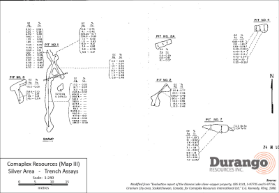
The program was successful in its goal of identifying and sampling the historic pits, Pit #1, Pit #2, Pit #6, and Pit #7, which were designated as high-priority targets due to their anomalously high silver and copper values. The historical trench map illustrating these targets is shown below in Figure 1.

A total of 51 channel and grab samples were taken during the survey of the property. Samples have been sent to Activation Laboratories in Thunder Bay, Ontario for analysis and assay results are expected to be received within approximately two weeks.

Readers are directed to Durango’s news release dated July 13, 2016, for full details on the exploration plan and targets.

http://www.durangoresourcesinc.com/2016/07/13/durango-initiates-sampling-program-at-dianna-lake-silver-prospect-in-saskatchewan/

Marcy Kiesman, CEO of Durango stated, “Our team was prompt in identifying the historical workings at Dianna Lake and successfully mapped and sampled the high-grade historical pits referenced in our July 13 news release. We are looking forward to receiving assay results in the coming weeks, at which time we will provide a full summary and analysis of the Dianna Lake sampling program and outline the next phase of exploration at the project.”

Figure 1. Trench locations and historical assays


Click Image To View Full Size

Larger image available at: http://www.durangoresourcesinc.com/dianna-lake-silver-saskatchewan/

About the Dianna Lake Silver Prospect

Durango’s Dianna Lake Silver Prospect covers a historical area in which, from 1968 to 1969, two high-grade, primarily native silver-bearing exploration targets of between 30,000 and 50,000 tonnes grading five to 10 ounces per ton silver, approximately 600 metres apart, were determined by trench grab sample assays, according to a historical evaluation report composed for Comaplex Resources in 1980(1) *.

* Potential quantities and grades are conceptual in nature. There has been insufficient exploration to define a mineral resource and it is uncertain if further exploration will result in the target being delineated as a mineral resource.

Additionally, the main silver-bearing zone is spatially associated with a large zone of low-grade, disseminated copper-silver mineralization in which “drilling of two IP anomalies indicated approximately five million tonnes averaging 0.4 ounce per ton Ag and 0.4 per cent Cu” (undefined category historical resource estimate), according to the same report (1) **.

** A qualified person has not done sufficient work to classify the historical estimate as current mineral resources or mineral reserves and the issuer is not treating the historical estimate as current mineral resources or reserves. Further work must be carried out to verify all historical information before a resource estimate is possible.

Fourteen additional induced polarization anomalies in the historical exploration area surrounding Dianna Lake and the nearby Doug Lake remain yet undrilled, according to the Comaplex Resources report (1), four of which occur within the property boundary of Durango’s Dianna Lake silver project.

Previous work on the claims was reported in 1969, 1980 and 1998 and included diamond drill holes, trenches, and pits primarily across two zones where mineralization was identified at or near surface. One zone was reported to have five trenches exposing Ag-Cu mineralization over approximately 80 metres. Historical grab samples from Pit 1 of this zone included ounce-per-ton silver values of 2,458.4, 684.4, 647.4, 600.2, 464.2, and 454.8 ounces per ton Ag. Out of 18 grab samples, 13 samples assayed between 185.0 and 2,458.4 ounces per ton. Pit 2 grab samples returned reported highs of 298.0 and 197.0 ounce per ton Ag (out of seven samples ranging from 12.2 to 298.0 ounces per ton Ag) (1). (The Company cautions that grab samples are selective and may not be representative of the mineralization on the property.)

The technical contents of this release were approved by Mr. Case Lewis, P.Geo., a qualified person as defined by National Instrument 43-101. The property has not been the subject of a National Instrument 43-101 report.

References

  1. (1)”Evaluation report of the Dianna Lake silver-copper property, CBS 3141, S-97735 and S-97736, Uranium City area, Saskatchewan, Canada, for Comaplex Resources International Ltd.” E.G. Kennedy, PEng, 1980.

About Durango Resources Inc.

Durango is a natural resources company engaged in the acquisition and exploration of mineral properties. The Company has a 100% interest in the Mayner’s Fortune and Smith Island limestone properties in northwest British Columbia, the Decouverte and Trove gold properties in the Abitibi Region of Quebec, and the NMX East, Lac Noirs, Montagne North and Boomerang lithium properties near the Whabouchi mine, the Buckshot graphite property near the Miller Mine in Quebec, the Whitney Northwest property near the Lake Shore Gold and Goldcorp joint venture in Ontario, as well as three sets of claims in the Labrador nickel corridor.

For further information on Durango, please refer to its website and its SEDAR profile at www.sedar.com.

Marcy Kiesman, Chief Executive Officer

Telephone: 604.428.2900 or 604.339.2243

Facsimile: 888.266.3983

Email: [email protected]

Website: www.durangoresourcesinc.com

Forward-Looking Statements

This document may contain or refer to forward-looking information based on current expectations, including, but not limited to future exploration or project development programs and the impact on the Company of these events. Forward-looking information is subject to significant risks and uncertainties, as actual results may differ materially from forecasted results. Forward-looking information is provided as of the date hereof and we assume no responsibility to update or revise them to reflect new events or circumstances. For a detailed list of risks and uncertainties relating to Durango, please refer to the Company’s prospectus filed on its SEDAR profile at www.sedar.com.

Neither TSX Venture Exchange nor its Regulation Services Provider (as that term is defined in the policies of the TSX Venture Exchange) accepts responsibility for the adequacy or accuracy of this release.
CLIENT FEATURE: Explor Resources (EXS: TSX-V) 609K oz Indicated / 470K oz Inferred Gold $EXS.ca

Posted by AGORACOM-JC at 12:29 PM on Wednesday, July 13th, 2016

Why Explor Resources?

  • Flagship Property Offers The Following:
  • NI 43-101 Resource – 609,000 oz Indicated / 470,000 Inferred
  • Teck Resources To Spend $12 MILLION To Earn 70%
  • Property Is 2.5 KM From Lake Shore Gold Mine
  • Property Is 13 KM From Downtown Timmins
  • 2nd Project 43-101 Open Pit Resource
  • 1.4 MILLION T Indicated @ 1.38% Copper
  • 2.09 MILLION T Inferred @ 1.26% Copper

ONTARIO AND NEW BRUNSWICK PROPERTIES CURRENTLY UNDER EXPLORATION

Timmins Porcupine West (TPW) (4300 ha)

  • NI 43-101 Resource: 609,000 oz Indicated
    470,000 oz Inferred Gold
  • 13 km from downtown Timmins
  • Property is 2.5 km, NE of LSG West Timmins Mine
  • Model: Hollinger McIntyre Gold System: 30,000,000 oz. Au
  • Discovery Hole 10-30 : 9.22g/tonne over 11.0 meters
  • Optioned to Teck Resources
  • Teck to spend $12,000,000 to earn 70% interest

Chester Copper & VMS Project (3500ha)

  • Mineral Target: Cu, Pb, Zn, Ag, & Au
  • 70 km SW of Bathurst NB
  • Structural Model Complete
  • 300 m wide x 2000m long mineralized Corridor identified
  • Ramp to ore zone (480 meter long (3m x 4m)
  • Optioned to Brunswick Resources (BRU)
  • Brunswick to spend $500,000 over 3 years
  • Explore to receive $40,000 and 5,000,000 shares of BRU
  • Open pit resource – NI 43-101 Resource: 1,400,000 Indicated t @ 1.38% Cu
    2,089,000 Inferred t @ 1.26 % Cu


Kidd Creek Project (2466 ha)

  • Mineral Target: Cu-Zn Ore
  • Located 1.0 km west of Kidd Creek Mine
  • Kidd Mine yielded 130M tonnes of Cu-Zn Ore since 1960
  • Numerous Geophysical max/min and IP Targets
  • Diamond Drilling winter 2015/2016

QUEBEC PROPERTIES CURRENTLY UNDER EXPLORATION

East Bay (3203 ha):

  • Mineral Target: Gold
  • Lies on Porcupine Destor Fault Zone, on strike with Beattie & Donchester mine
  • Historical channel samples by Lacana Mining in 1982 including: 0.81 oz/ton over 5ft; 0.16 oz/ton over 6 ft; 0.10 oz/ton over 10 ft
  • Wrap around Clifton Star

Nelligan (1198 ha):

  • Mineral Target: Nickel
  • Located in Val d’Or mining district of Quebec
  • Historical grab samples of 10% Ni and 0.6% Cu obtained by INCO
  • Discovered anomalous Nickel, Copper Zones

Launay (2250 ha):

  • Mineral Target: Nickel
  • Mineralized zones contained in mafic volcanic rocks
  • Contiguous to Royal Nickel’s Dumont property (NW end)

12 Month Stock Chart

Durango Initiates Sampling Program at Dianna Lakesilver Prospect In Saskatchewan $DGO.ca

Posted by AGORACOM-JC at 10:10 AM on Wednesday, July 13th, 2016

Logo

  • Commencing a sampling program this coming week at its 100%-owned Dianna Lake Silver Prospect near Uranium City, Saskatchewan
  • Sampling and mapping program will commence on July 17, 2016 and will take place over approximately one week

Vancouver, BC / July 13, 2016 – Durango Resources Inc. (TSX.V-DGO), (the “Company” or “Durango”) is pleased to announce that it will be commencing a sampling program this coming week at its 100%-owned Dianna Lake Silver Prospect near Uranium City, Saskatchewan.

The Company confirms that the sampling and mapping program will commence on July 17, 2016 and will take place over approximately one week. The program aims to achieve the following goals:

  • -Verify and expand the area of historical anomalous assay values in and around the main Dianna Lake silver showings at Pit #1, Pit #2, and Pit #6 by means of outcrop mapping and sampling, and channel sampling;-Conduct detailed mapping and sampling across the four undrilled and underexplored historically identified IP (induced polarization) anomalies. Historical drilling of two other IP anomalies on the Dianna Lake property defined the bulk of the current zone of mineralization on the property (1); and-Establish the extent of the copper anomalies identified in Pit #7. Historical samples in this location yielded up to 5.87% Cu and 2.6 oz/t Ag (historical sample of up to 5.87% Cu and 2.6 oz/t Ag (1)).

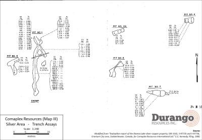
The following historical samples are summarized in an evaluation report prepared for Comaplex Resources Corporation following a drilling, geophysical, and surface sampling program in 1980 (1). Pit dimensions are summarized in Table 1. Historical assay results for the most significant pits are shown below in their entirety in Table 2a and 2b, with a map of the trench locations shown in Figure 1. All samples from the trenches were recorded as grab samples. No significant work has been reported on the property since this program.

Table 1. Dimensions of significant historical trenches

Trench Length (m) # of samples taken Remarks
Pit #1 (main) 14.6 17 Main section of Pit 1
Pit #1 (north extension) 7.1 10 Northern extension of Pit 1
Pit #2 7.4 7
Pit #6 7.8 4
Pit #7 8.4 11

Table 2a. Historical samples from the Dianna Lake property (arranged in order of Ag content)

Pit #1 (Main) Pit #1 (North) Pit #2
Ag (oz/t) % Cu Ag (oz/t) % Cu Ag (oz/t) % Cu
2458.4 336.0 0.05 298.0 0.46
684.4 0.05 225.5 0.14 197.0 0.65
647.4 9.8 0.17 20.4 0.77
600.2 6.0 0.31 20.4 0.02
464.6 0.10 4.1 0.42 16.2 0.26
454.8 3.6 0.36 14.2 0.36
407.2 0.01 3.4 4.92 12.2 0.46
405.4 2.8 0.73
383.4 1.5 0.43
321.0 1.2 0.43
242.6 0.02
240.5
185.0 0.02
56.4
31.0 0.10
17.0 0.02
16.7 0.02

Table 2b. Historical samples from the Dianna Lake property (arranged in order of Ag content)

Pit #6 (Main) Pit #7 (North)
Ag (oz/t) % Cu Ag (oz/t) % Cu
54.6 0.1 8.4 0.19
45.1 0.04 5.0 4.92
18.2 0.05 4.7 2.35
11.1 0.19 3.1 1.15
1.6 0.19 2.6 5.87
2.6 1.18
2.4 1.95
2.3 1.06
2.1 0.62
1.9 0.94
1.5 0.48

(The Company cautions that grab samples are selective and may not be representative of the mineralization on the property.)

Figure 1. Trench locations and historical assays


Click Image To View Full Size

Larger image available at: http://www.durangoresourcesinc.com/dianna-lake-silver-saskatchewan/

About the Dianna Lake Silver Prospect

Durango’s Dianna Lake Silver Prospect covers a historical area in which, from 1968 to 1969, two high-grade, primarily native silver-bearing exploration targets of between 30,000 and 50,000 tonnes grading five to 10 ounces per ton silver, approximately 600 metres apart, were determined by trench grab sample assays, according to a historical evaluation report composed for Comaplex Resources in 1980(1) *.

* Potential quantities and grades are conceptual in nature. There has been insufficient exploration to define a mineral resource and it is uncertain if further exploration will result in the target being delineated as a mineral resource.

Additionally, the main silver-bearing zone is spatially associated with a large zone of low-grade, disseminated copper-silver mineralization in which “drilling of two IP anomalies indicated approximately five million tonnes averaging 0.4 ounce per ton Ag and 0.4 per cent Cu” (undefined category historical resource estimate), according to the same report (1) **.

** A qualified person has not done sufficient work to classify the historical estimate as current mineral resources or mineral reserves and the issuer is not treating the historical estimate as current mineral resources or reserves. Further work must be carried out to verify all historical information before a resource estimate is possible.

Fourteen additional induced polarization anomalies in the historical exploration area surrounding Dianna Lake and the nearby Doug Lake remain yet undrilled, according to the Comaplex Resources report (1), four of which occur within the property boundary of Durango’s Dianna Lake silver project.

Previous work on the claims was reported in 1969, 1980 and 1998 and included diamond drill holes, trenches, and pits primarily across two zones where mineralization was identified at or near surface. One zone was reported to have five trenches exposing Ag-Cu mineralization over approximately 80 metres. Historical grab samples from Pit 1 of this zone included ounce-per-ton silver values of 2,458.4, 684.4, 647.4, 600.2, 464.2, and 454.8 ounces per ton Ag. Out of 18 grab samples, 13 samples assayed between 185.0 and 2,458.4 ounces per ton. Pit 2 grab samples returned reported highs of 298.0 and 197.0 ounce per ton Ag (out of seven samples ranging from 12.2 to 298.0 ounces per ton Ag) (1). (The Company cautions that grab samples are selective and may not be representative of the mineralization on the property.)

The technical contents of this release were approved by Mr. Case Lewis, P.Geo., a qualified person as defined by National Instrument 43-101. The property has not been the subject of a National Instrument 43-101 report.

References

  1. (1)”Evaluation report of the Dianna Lake silver-copper property, CBS 3141, S-97735 and S-97736, Uranium City area, Saskatchewan, Canada, for Comaplex Resources International Ltd.” E.G. Kennedy, PEng, 1980.

About Durango Resources Inc.

Durango is a natural resources company engaged in the acquisition and exploration of mineral properties. The Company has a 100% interest in the Mayner’s Fortune and Smith Island limestone properties in northwest British Columbia, the Decouverte and Trove gold properties in the Abitibi Region of Quebec, and the NMX East, Lac Noirs, Montagne North and Boomerang lithium properties near the Whabouchi mine, the Buckshot graphite property near the Miller Mine in Quebec, the Whitney Northwest property near the Lake Shore Gold and Goldcorp joint venture in Ontario, as well as three sets of claims in the Labrador nickel corridor.

For further information on Durango, please refer to its website and its SEDAR profile at www.sedar.com.

Marcy Kiesman, Chief Executive Officer

Telephone: 604.428.2900 or 604.339.2243

Facsimile: 888.266.3983

Email: [email protected]

Website: www.durangoresourcesinc.com

Forward-Looking Statements

This document may contain or refer to forward-looking information based on current expectations, including, but not limited to future exploration or project development programs and the impact on the Company of these events. Forward-looking information is subject to significant risks and uncertainties, as actual results may differ materially from forecasted results. Forward-looking information is provided as of the date hereof and we assume no responsibility to update or revise them to reflect new events or circumstances. For a detailed list of risks and uncertainties relating to Durango, please refer to the Company’s prospectus filed on its SEDAR profile at www.sedar.com.

Neither TSX Venture Exchange nor its Regulation Services Provider (as that term is defined in the policies of the TSX Venture Exchange) accepts responsibility for the adequacy or accuracy of this release.

Durango Acquires Silver Property Near Chibougamou, Quebec $DGO.ca

Posted by AGORACOM-JC at 10:34 AM on Thursday, July 7th, 2016

Logo

  • Acquired a series of claim cells adjacent to and near TomaGold Corporation’s Obalski project near Chibougamau, Quebec
  • Claims are host to a historic outcrop sample which was reported to contain 220,000 ppm (22.0%) silver, 131,130 ppm (13.1%) copper, and 1,866 ppb gold
  • Unique sample is one of only nine samples from the entire province of Quebec recorded in the SIGEOM sample database which contain greater than 100,000ppm silver.

Vancouver, BC / July 7, 2016 – Durango Resources Inc. (TSX.V-DGO), (the “Company” or “Durango”) is pleased to announce that is has acquired a series of claim cells adjacent to and near TomaGold Corporation’s Obalski project near Chibougamau, Quebec.

The claims are host to a historic outcrop sample which was reported to contain 220,000 ppm (22.0%) silver, 131,130 ppm (13.1%) copper, and 1,866 ppb gold. The unique sample is one of only nine samples from the entire province of Quebec recorded in the SIGEOM sample database which contain greater than 100,000ppm silver. (1) *

* The reader is cautioned that a Qualified Person has not verified the sample cited in this release, as the sample material no longer exists. The sample is a selected sample that may not be representative of mineralization hosted on the property.

President Marcy Kiesman stated, “We are excited to acquire this new property in Quebec with exceptionally high silver, gold and copper values and in close proximity to our Trove Windfall Lake and Decouverte gold projects. The property’s proximity to Chibougamou is also highly advantageous from a logistical perspective, as our team will be able to access all three properties from the same location. This will allow our team to segue between projects with minimal cost and interruption.”

The technical contents of this release were approved by Mr. Case Lewis, P.Geo., OGQ member #1904, a Qualified Person as defined by National Instrument 43-101. The property has not yet been the subject of a National Instrument 43-101 report.

References

  1. (1)SIGEOM unique sample 2010052478.

About Durango

Durango is a natural resources company engaged in the acquisition and exploration of mineral properties. The Company has a 100% interest in the Mayner’s Fortune and Smith Island limestone properties in northwest British Columbia, the Decouverte and Trove gold properties in the Abitibi Region of Quebec, and certain lithium properties near the Whabouchi mine, the Buckshot graphite property near the Miller Mine in Quebec, the Dianna Lake silver project in northern Saskatchewan, the Whitney Northwest property near the Lake Shore Gold and Goldcorp joint venture in Ontario, as well as three sets of claims in the Labrador nickel corridor.

For further information on Durango, please refer to its SEDAR profile at www.sedar.com.

Marcy Kiesman, Chief Executive Officer

Telephone: 604.428.2900 or 604.339.2243

Facsimile: 888.266.3983

Email: [email protected]

Website: www.durangoresourcesinc.com

Forward-Looking Statements

This document may contain or refer to forward-looking information based on current expectations, including, but not limited to the development, commencement and completion of future exploration or project development programs and the impact on the Company of these events. Forward-looking information is subject to significant risks and uncertainties, as actual results may differ materially from forecasted results. Forward-looking information is provided as of the date hereof and we assume no responsibility to update or revise them to reflect new events or circumstances. For a detailed list of risks and uncertainties relating to Durango, please refer to the Company’s prospectus filed on its SEDAR profile at www.sedar.com.

Neither TSX Venture Exchange nor its Regulation Services Provider (as that term is defined in the policies of the TSX Venture Exchange) accepts responsibility for the adequacy or accuracy of this release.

Durango Plans to Explore Silver Prospect $DGO.ca

Posted by AGORACOM-JC at 10:33 AM on Wednesday, June 29th, 2016

Logo

  • Company has engaged its exploration team and is evaluating logistics for a sampling program on its wholly owned Dianna Lake Silver property located in northern Saskatchewan.
  • Marcy Kiesman, CEO of Durango, comments, “Durango is fortunate to have multiple properties positioned for discovery in its portfolio. With silver poised to be a top performing commodity for 2016, it is an exciting opportunity to explore an historic high grade project coupled with today’s new technology.”

Vancouver, BC / June 29, 2016 – Durango Resources Inc. (TSX.V-DGO), (the “Company” or “Durango”) announces that further to the news releases of March 22 and April 21,2016, the Company has engaged its exploration team and is evaluating logistics for a sampling program on its wholly owned Dianna Lake Silver property located in northern Saskatchewan.

Marcy Kiesman, CEO of Durango, comments, “Durango is fortunate to have multiple properties positioned for discovery in its portfolio. With silver poised to be a top performing commodity for 2016, it is an exciting opportunity to explore an historic high grade project coupled with today’s new technology.”

Additional details about the Dianna Lake property are on the website.

About Durango

Durango is a natural resources company engaged in the acquisition and exploration of mineral properties. The Company has a 100% interest in the Mayner’s Fortune and Smith Island limestone properties in northwest British Columbia, the Decouverte and Trove gold properties in the Abitibi Region of Quebec, and certain lithium properties near the Whabouchi mine, the Buckshot graphite property near the Miller Mine in Quebec, the Dianna Lake silver project in northern Saskatchewan, the Whitney Northwest property near the Lake Shore Gold and Goldcorp joint venture in Ontario, as well as three sets of claims in the Labrador nickel corridor.

For further information on Durango, please refer to its SEDAR profile at www.sedar.com.

Marcy Kiesman, Chief Executive Officer

Telephone: 604.428.2900 or 604.339.2243

Facsimile: 888.266.3983

Email: [email protected]

Website: www.durangoresourcesinc.com

Forward-Looking Statements

This document may contain or refer to forward-looking information based on current expectations, including, but not limited to the purchase, development, completion of financing, commencement and completion of future exploration or project development programs and the impact on the Company of these events. Forward-looking information is subject to significant risks and uncertainties, as actual results may differ materially from forecasted results. Forward-looking information is provided as of the date hereof and we assume no responsibility to update or revise them to reflect new events or circumstances. For a detailed list of risks and uncertainties relating to Durango, please refer to the Company’s prospectus filed on its SEDAR profile at www.sedar.com.

Neither TSX Venture Exchange nor its Regulation Services Provider (as that term is defined in the policies of the TSX Venture Exchange) accepts responsibility for the adequacy or accuracy of this release.

AGORACOM Welcomes Tartisan Resources (TTC: CSE) – Situated in the Andes which hosts 12 operating mines, 3 of which are world class producers $TTC.ca

Posted by AGORACOM-JC at 8:43 AM on Tuesday, May 3rd, 2016

TTC: CSE

  • US $250,000 recommended work program
  • Grab samples of note:
    • 2.273 g Au/t
    • 1,814 g Ag/t
  • Gold and silver in Perú’s prolific North- Central Mineralized Belt
  • “La Victoria” lies within this 300 km belt along the Andes which hosts 12 operating mines, 3 of which are world class producers.
  • La Arena owned by Tahoe Resources, Lagunas Norte (Alto Chicama) owned by Barrick Gold Corporation (TSX:ABX) and Santa Rosa owned by Compañia Minera Aurífera Santa Rosa (COMARSA).
  • La Victoria has excellent potential to host high-grade oxide and sulphide epithermal Au, Ag vein systems as well as potential for a large, low-grade, disseminated Cu, Au and Ag (porphyry-type) deposit.

  • Situated in the District of Huandoval, Province of Pallasca, Department of Ancash in the Republic of Peru on the continent of South America; approximately 425 kilometers (km) north-northwest of Lima. It is located within the Instituto Geografico Nacional (IGN) map sheet 17-h Pallasca.
  • Claims are centered on Universal Transverse Mercator (“UTM”) coordinate system, Provisional South American Datum 1956 (“PSAD56″), zone 18L, 174202 meters (m) East and 9081240 meters North; or geographic coordinate system 77º 57′ 15″ of west Longitude and 8º 18′ 10” of south Latitude.

  • Located in a remote area of Ancash on the western slopes of the Peruvian Andes at elevations that vary from 3000 m to 4200 m above sea level.
  • Landscape includes rocky mountaintops emerging from wide grassy valleys carved by glacial activity (Figure 7.1a and 7.1b).
  • Fertile land is abundant at lower altitudes. The vegetation at lower altitudes includes eucalyptus and pine trees, pasture and garden vegetables whereas the vegetation above 4000 m is restricted to grasses such as the ichu, cactus and some flower species.
  • Temperature on the Property varies between -3 and 20 degrees celsius (“ºC”) with an annual average of approximately 13 ºC. There are only two seasons: the rainy season from November to March along with snowfall during this period, and the dry season from April to October which is also cold.

The Property is located about 10 hours away from Lima by truck with a travel distance of approximately 600 km. Exploration and mining activity can function year-round; however, it is expected that there will be down time during the rainy season because of the poor road conditions. Extreme caution is advised during this period. Figure 6.2 illustrates the route to the Property whereas the travel times, distances and road conditions are listed in Table 7.1.

Route Distance (km) Time (hours) Condition
Lima – Chimbote 440 5.75 Paved road
Chimbote – Santa 11 0.25 Paved road
Santa – Estacion Chuquicara 66 1 Paved road
Estación Chuquicara – La Galgada 30 0.5 Paved road
La Galgada – Pallasca 40 2 Maintained gravel road
Pallasca Property 6 0.5 Maintained gravel road

The nearest road to the San Markito and Victoria anomalies is approximately 3 km away, therefore, the Phase I exploration was performed using horses and donkeys as the main transport method. Water is not abundant within these areas but is available at higher elevations. Infrastructure improvements such as road, water reserve and electrical lines (if feasible) should be implemented before the Phase II exploration operations.

Hub On AGORACOM / Corporate Profile / Read Release

With Gold And Silver On The Move, These 3 Juniors Are Set To Capitalize $EXS.ca $AMK.ca $UBR.ca

Posted by AGORACOM at 12:08 PM on Friday, April 29th, 2016

Gold and Silver Go Boom. GREAT News For These Juniors!

Exs_logo

EXS: TSX-V, OTCQX:EXSFF

  • 609,000 Ozs Indicated / 470,000 Inferred
  • Teck Resources To Spend $12 MILLION To Earn 70%

View Profile

—————————————

AMK: TSX-V, ACKRF: OTC Pink

  • Included In Seabridge Gold Plan To Take KSM Into Production
  • Recent samples average 27,092 gm/tonne silver and 248 gm/tonne gold
  • Adjacent area host to Over 130M Ozs Gold, 800 million Ozs silver, 20 billion pounds copper

View Profile

—————————————-

Uragold_new

UBR: TSX-V, URAGF: OTC

  • Planned Dividend To Shareholders Via Gold Assets Spin Out
  • Largest Historical Placer Gold Deposit In Eastern North America
  • Past Gold Producer
  • Word Renowned Geophysical Team
  • Core Quartz Conversion To Solar Grade Silicon Metal Received $5,000,000 Funding + 20 Year Offtake Agreement For Asia

View Profile

Start Your Research And Discover Your Next Great Junior Resources Company

CLIENT FEATURE: American Creek’s Treaty Creek adjacent area host to Over 130M Oz of Gold, 800 million ounces of silver and 20 billion pounds of copper $AMK.Ca

Posted by AGORACOM-JC at 1:51 PM on Tuesday, April 26th, 2016

AMK: TSX-V

WHY AMERICAN CREEK RESOURCES?

  • Mineralization in the Treaty Creek claims area lies within the same broad hydrothermal system that generated the several deposits on the Seabridge Gold KSM and the Pretivm Brucejack properties that lie immediately southwest of the Treaty Creek claims
  • So far over 130 million ounces of gold, 800 million ounces of silver and 20 billion pounds of copper (all categories included), representing one of the greatest concentrations of metal value on the planet, have been delineated within the geological system shared by KSM, Brucejack, and Treaty Creek.

RECENT HIGHLIGHTS

  • Specimens from the structure averages 27,092 gm/tonne silver and 248 gm/tonne gold
  • Results from outcrop specimens of high grade material collected on its Electrum property from the Shiny Cliff vein on the North Face Showing Read More
  • TSX Venture Exchange approved the Amended and Restated Purchase Agreement regarding the Treaty Creek NSR that was previously announced April 13, 2016. Read Our Recent Blog

Exceptional Properties

Electrum Gold-Silver Property, British Columbia – 100% owned

The Electrum property has a rich history with some of the highest grade hand-mined ore mined in North America combined with excellent logistics. The property is located directly between two high-grad vein gold/silver mines; the past producing Silbak Premier mine and Pretiums high-grade Brucejack mine (production in 2017).All three lie within the Iskut mineral district (a particularly prolific part of the Canadian Cordillera) with numerous geological similarities between them.

The Electrum Property holds significant potential to attract mining companies when considering its high-grade nature combined with the exceptional logistics in place.

  • Located in the prolific Golden Triangle of northwestern British Columbia, an area encompassing mineral rich belts that host more than 43 past producing mines including Eskay Creek, Silbak Premier, Granduc and Big Missouri.It is a hotbed of activity with one new mine having come online in 2015 (Imperial Mines Red Chris) and another scheduled for 2017 (Pretium Brucejack) and at least three more world-class mining projects headed toward production.
  • Located in a particularly rich valley with 4 past producing commercial mines and a 5th in the adjacent valley.
  • Includes the historic East Gold Mine that had intermittent small-scale production of approximately 46 tonnes of ore with grades averaging 1,661 grams of gold per tonne and 2,596 grams of silver per tone (roughly 50oz gold with 75oz silver).
  • Mineralization is believed to be very similar to the silver-gold-base metal veins responsible for the precious metal mineralization found in the Silbak Premier Mine and the Big Missouri mines (located in same extended valley).
  • Pretiums Brucejack Summary Report (for exploration) compares itself geologically to the Silbak Premier mine as well.
  • Exceptional gold and silver assays including 440 g/t gold with 400 g/t silver over 0.52m, with numerous silver intervals of 583g/t, 501 g/t, 420 g/t, 384 g/t in core, and surface samples of 80.96 g/t gold with 80,818 g/t silver, 694 g/t gold with 550 g/t silver, 54.77 g/t gold with 14,903 g/t silver, 615 g/t gold with 616 g/t silver.
  • A very successful program was run in 2015 wherein:
    • A new approach focusing on high-grade was employed very successfully
    • A new zone of gold / silver mineralization was discovered
    • A better understanding of the property geology was obtained
    • Surface samples from the structure averages 27,092 gm/tonne silver and 248 gm/tonne gold


  • The program proved the Electrum Property has multiple high-grade gold-silver epithermal breccia vein systems and gave us a better understating of their sequencing.
  • Excellent logistics including road access, power located 2 km away and a bulk tonnage shipping port and supportive mining town located just40 km away in a mining friendly jurisdiction.

The high-grade ELECTRUM PROPERTY recently had a program run on it. CLICK HERE for the Electrum presentation and HERE for the 2015 drill program presentation. The highly mineralized gossans on the Electrum are shown in the image at the top of this page.

2015 Drill Program Presentation

Treaty Creek Gold-Copper Property, British Columbia – 51% Joint Venture

Treaty Creek Property


Treaty Creek is located in British Columbia’s prolific Golden Triangle; one of the richest areas of mineralization in the world with one new mine having come online in 2015 (Imperial Mines Red Chris) and another scheduled for 2017 (Pretium Brucejack) and at least three more world-class mining projects headed toward production.

Mineralization in the Treaty Creek claims area lies within the same broad hydrothermal system that generated the several deposits on the Seabridge Gold KSM and the Pretivm Brucejack properties that lie immediately southwest of the Treaty Creek claims. So far over 130 million ounces of gold, 800 million ounces of silver and 20 billion pounds of copper (all categories included), representing one of the greatest concentrations of metal value on the planet, have been delineated within the geological system shared by KSM, Brucejack, and Treaty Creek.

Seabridge Gold’s KSM is the world’s largest undeveloped gold/silver project by reserves while Pretium’s Brucejack is the highest grading undeveloped large-scale gold project in the world.KSM has just past the environmental and permitting stage while the Brucejack is in construction phase.
Treaty Creek is part of the same large hydrothermal system as it’s neighbours, hosts the same bedrock geology as its neighbours, the same magneto-telluric (MT) anomalies that proved to be large deposits on the neighbours claims, the same major fault system (Sulphurets) that is responsible for KSM’s deposits, and initial exploration and drilling show similar results to initial drilling on KSM.

The Treaty Creek property is in a strategic location as it’s included in Seabridge’s plan for the KSM to go into production. Seabridge has proposed twin tunnels that would take the KSM ore through American Creek’s Treaty Creek property to a processing plant and tailings pond.